North-West Pamir
Upper reaches of the Fedchenko Glacier
Peak: Bespokojnykh (5600 m) via its eastern ridge, 4A category of difficulty, combined
Description
FIRST ASCENT BY THE ALPINIAD GROUP OF THE REGIONAL COUNCIL OF THE “ZENIT” VOLUNTARY SPORTS SOCIETY
Description compiled by Buchikov — V. Butkov
Chelyabinsk Alpine Federation, 1940
Introduction
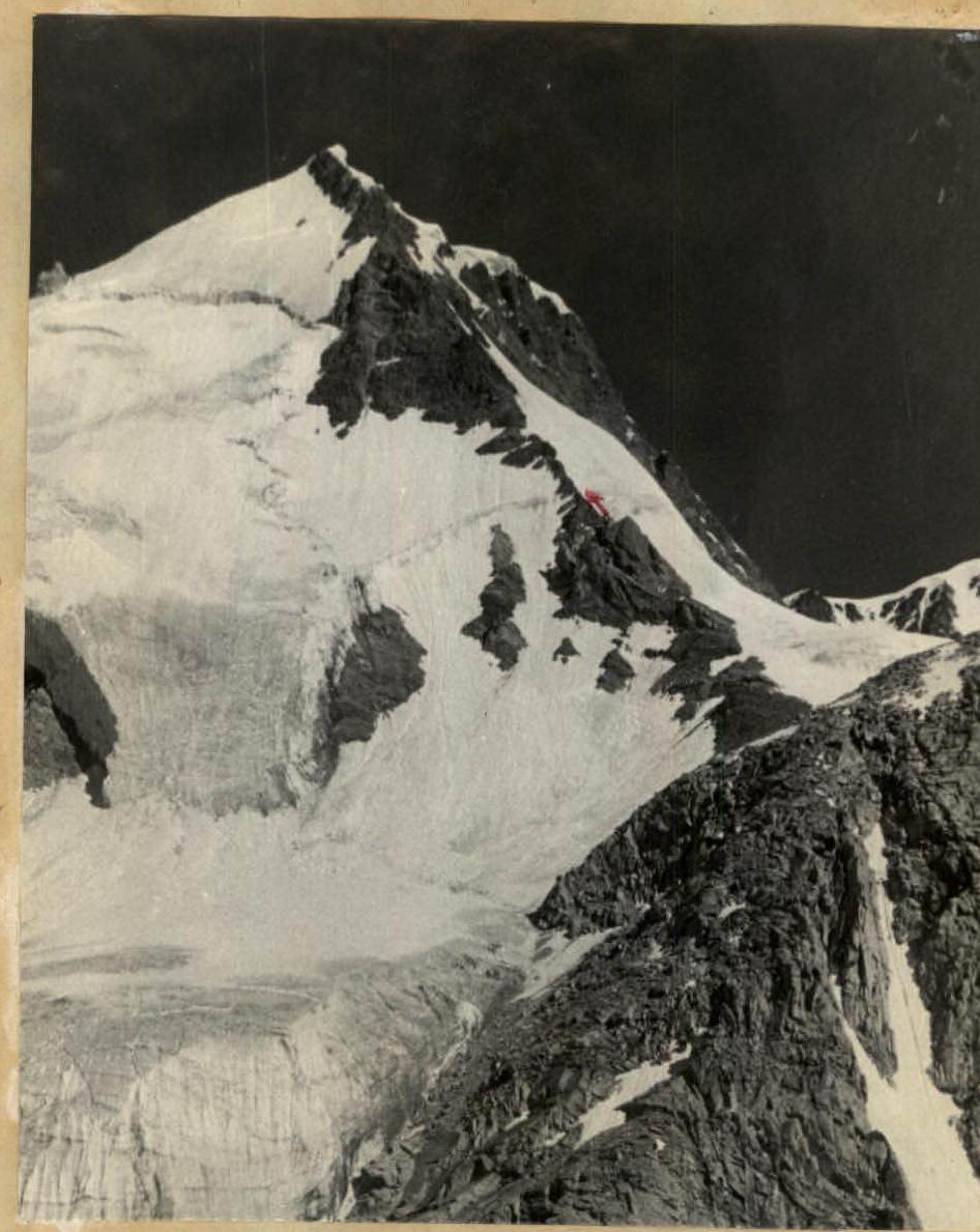
Peak Bespokojnykh (5600 m) is located in the southern part of the Akademiya Nauk SSSR ridge. The summit is clearly visible from the “4300” base camp in the area of the Abdukagor-II pass (see photos 1 and 2).
The first ascent to the summit was made by SKAN climbers in 1960 via the north-west ridge. The group believes that the “Classification Table of Peaks in the USSR” approved by the Presidium of the USSR Alpine Federation (protocol No. 21213 dated 2.04.1968) contains an inaccuracy in the naming of the mentioned route, namely:
- it states: 4. Bespokojnykh Peak 5600 3B combined, via the NW ridge from the Abdukagor-II pass (p. 49).
- it should read: 4. Bespokojnykh Peak 5600 3B combined via the W ridge from the Abdukagor glacier.
In 1967, a group of climbers from the Chelyabinsk Regional Council of the “Trud” Voluntary Sports Society consisting of Teplykh and Sannikov attempted to make the first ascent of Bespokojnykh Peak via the south-east ridge. The group turned back without completing the challenging snow-and-ice corniced ridge.
After consulting with the participants of the expedition of the Chelyabinsk Regional Council of the “Trud” Voluntary Sports Society, the south-east ridge was chosen as the route for the described first ascent, which was successfully completed on December 9-12, 1968, by two interacting groups.
At the summit, a note from the SKAN group (led by Smirnov) dated July 26, 1960, was found. No signs of other groups were found on the south-east ridge itself.
General characteristics of the route
The route completed consists of the following main stages:
- Ascend from the “4300” base camp to the rocky outcrop (“claw”) on the slope of Bespokojnykh Peak. (R1–R3).
- Ascend via the icefall and snowy slope to reach the south-east ridge. (R4–R6).
- Ascend the rocky ascent of the ridge to the “gendarme” on the ridge. (R7).
- Overcome the “gendarme” and continue ascending the ridge to the summit. (R8, R9).
- Descend via the ascent route.
Group composition
Group I
- Butkov V.L. — 2nd sports category, Chelyabinsk region, “Zenit” Voluntary Sports Society, participant.
- Vakhmenin A. — 2nd sports category, Chelyabinsk region, “Zenit” Voluntary Sports Society, participant.
- Zinchenko A. — 1st sports category, Chelyabinsk region, “Zenit” Voluntary Sports Society, leader.
- Oparin Yu.A. — 2nd sports category, Chelyabinsk region, “Zenit” Voluntary Sports Society, participant.
- Perekhodiuk V. — Candidate Master of Sports, Chelyabinsk region, “Zenit” Voluntary Sports Society, participant.
- Ponkina T. — 1st sports category, Chelyabinsk region, “Zenit” Voluntary Sports Society, participant.
Group II
- Galchenko V. — 2nd sports category, Chelyabinsk region, “Trud” Voluntary Sports Society, participant.
- Konev V. — 2nd sports category, Chelyabinsk region, “Zenit” Voluntary Sports Society, leader.
- Silchenko S.L. — 2nd sports category, Chelyabinsk region, “Zenit” Voluntary Sports Society, participant.
- Likhinim A. — 2nd sports category, Chelyabinsk region, “Zenit” Voluntary Sports Society, participant.
All the listed climbers were part of the Alpinade of the Chelyabinsk Regional Council of the “Zenit” Voluntary Sports Society, which operated in the upper reaches of the Fedchenko Glacier from July 28 to August 25, 1968.
The groups were released on the route by the First Releasing Officer of the Alpinade, Master of Sports of the USSR LEVIN M.S. (route validation certificate is attached).
Technical description of the route
From the “4300” base camp located on the left (orographic) lateral moraine of the Abdukagor-II glacier, exit onto the glacier in the direction of the rocky outcrop “Khitsana” where the glacier bends. This is the most dangerous section of the glacier — a steep, crevassed ice slope (200–250 m). Further, the slope becomes more gentle, and movement continues across a gentle snow-and-ice slope with moderate undulations in the direction of the northern tributary of the Abdukagor glacier (landmark — a large rocky outcrop to the left under its icefall). After overcoming a steep snow ascent, we reach the glacier where a night halt is organized (see photo No. 2). From the “4300” camp to the overnight halt — 5–6 hours.
From the overnight halt, after traversing the heavily crevassed glacier, we approach the ice slope to the left of the rocky outcrop.
Alternative route to the south-east ridge: overcome the icefall to the right of the “rocky outcrop”, exit onto the glacier plateau, and traverse under the eastern slopes of Bespokojnykh Peak. Traverse under the bergschrund to the south, reach the spot where the group overcame the bergschrund, and continue along the same path. This option requires scouting a path through the icefall, which the group in the upper reaches of the Fedchenko Glacier had not encountered before. It is significantly more challenging than the western icefall of the Ushba pass.
Via a not clearly defined couloir of the steep ice slope (steepness ~60°), belaying with ice screws (6–7 screws), exit onto the snowy slope.
Further along the snowy slope (belaying with an ice axe), approach under the bergschrund with a height difference of 1.5–2 m. After overcoming the bergschrund with the help of artificial footholds, traverse the slope to the left under the beginning of the rocky wall. Movement is alternating, belaying with an ice axe.
The rocky wall consists of weathered, heavily eroded rocks with an average steepness of 60° and up to 70° in some places.
When moving along it, caution is required. Movement is alternating, belaying via outcrops and screws.
The path along the wall takes 4–5 hours; the total height of the wall is 350 m. The wall ends with a “gendarme” 10–12 m high.
Overcome the “gendarme” directly, then rappel down to a small ice platform. Here, one can:
- set up an overnight stay;
- carve out a platform in the ice for a tent.
The further route is along the ridge. The first part of the ridge is rocky, with a steepness of 45–50°, belaying via outcrops. The path from the “gendarme” to the summit takes 1.5–2 hours. The summit area is snowy with rocky outcrops. A cairn is built on the rocks.
Necessary equipment:
- Main ropes — 40 m.
- Rock pitons — 7 pcs.
- Ice screws — 10 pcs.
Route recommendations:
- Group size not more than 4 people.
- It is mandatory to plan an overnight stay on the route.
- Necessary number of rock pitons — 8–10 pcs., ice screws — 4–5 pcs.
Conclusion
The group considers the route completed to be comparable to the following classified routes:
- Teke-Tor via the western ridge;
- Chokan Valikhanov Peak via the north-east ridge.
The route is technically more challenging than the classified 3B category route to Bespokojnykh Peak via the north-west ridge.
The group assesses the route as corresponding to the 4A category of difficulty and petitions the Alpine Federation of the USSR to include it in the “All-Union Classification of Peaks.”
Compiler of the description
 Coach and second releasing officer of the Alpinade V. Tamplon
Appendix
Route validation certificate
This is to confirm that, based on the results of the review of the first ascent to Bespokojnykh Peak via the southern ridge, I have validated:
- Konev V. — leadership;
- participation: Butkov V., Vakhmenin A., Oparin Yu., Perekhodiuk V., Ponkina T., Galchenko V., Likhinim A., Silchenko S., Zinchenko A.
(According to the decision of the bureau of the section of the Regional Council of the “Zenit” Voluntary Sports Society, Zinchenko A.'s leadership was not validated).
Head and First Releasing Officer of the Alpinade of the Chelyabinsk Regional Council of the “Zenit” Voluntary Sports Society 1968, Master of Sports of the USSR, senior alpine instructor (certificate No. 0245) — Levin M.S.
The description has been verified. I consider the following: the classified 3B category route mentioned on p. 6 was not found by these groups, so one can only speak of the likelihood of its assessment; the ridge traversed is different, and not the south-east route, which, according to the same participants who conducted many debriefs, is not more challenging than the 3B category.
Deputy Chairman of the Chelyabinsk Regional Alpine Federation — Levin M.S. February 11, 1970
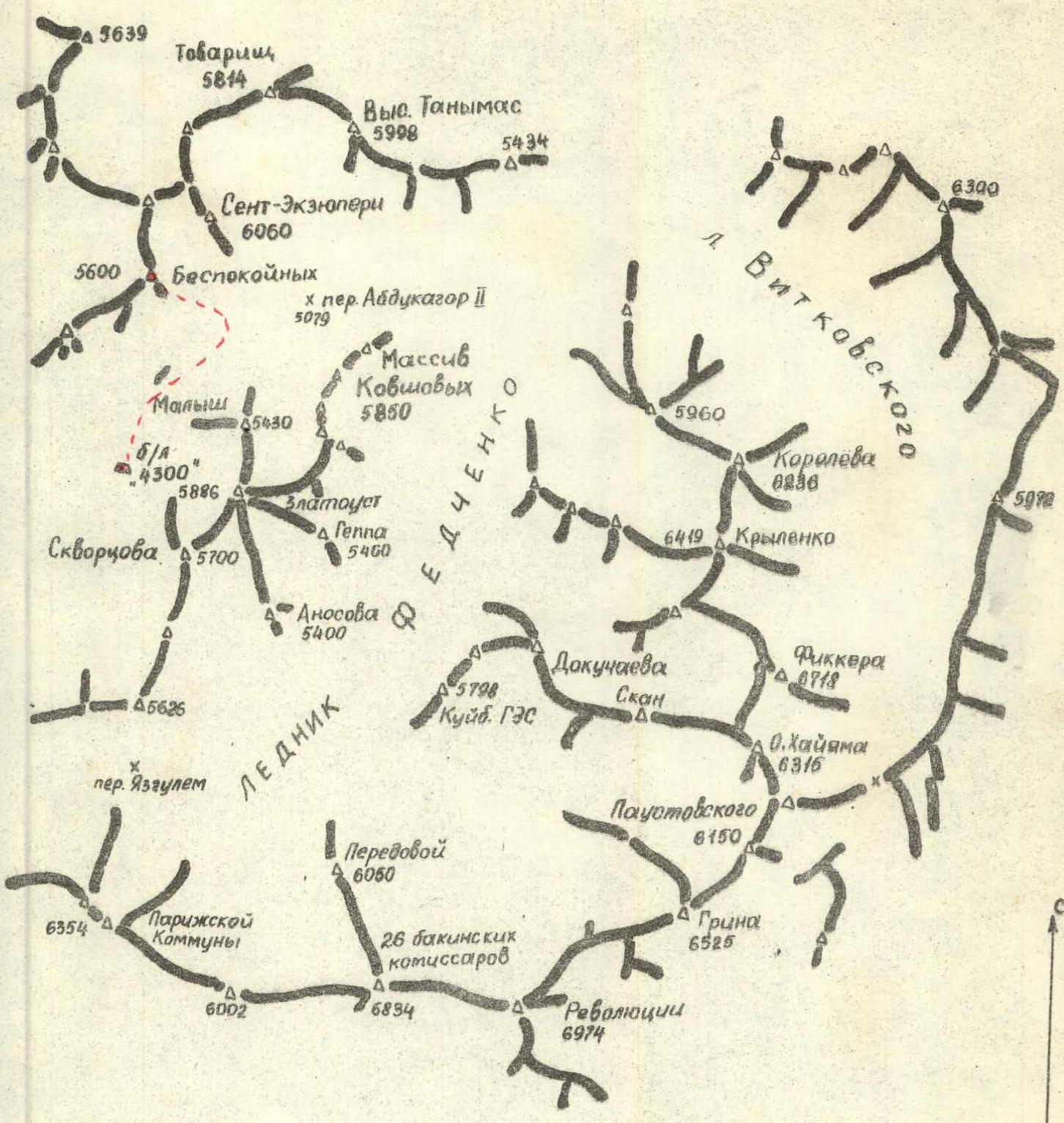
CENTRAL PAMIR. Ridges of the upper reaches of the Fedchenko Glacier. The route of ascent to Bespokojnykh Peak is shown with a dotted line.
Table of main characteristics
First ascent route: Bespokojnykh Peak (5600 m) via the southern ridge.
| Section No. | Average steepness | Height gain (m) | Characteristics of sections and conditions for overcoming: terrain characteristics | Technical difficulty | Method of overcoming | Rock pitons used (pcs.) | Ice screws used (pcs.) |
|---|---|---|---|---|---|---|---|
| R1 | 40° | 150 | ice | difficult | steps, screws | - | 1 |
| R2 | 15° | 460 | snow-and-ice slope | easy | in rope teams | - | - |
| R3 | 45° | 15 | snowy ascent | moderate | ice axe | - | - |
| R4 | 60° | 75 | ice slope | difficult | screws, crampons, steps | - | 6 |
| R5 | |||||||
| 40° | 100 | snowy slope with bergschrund | difficult | ice axe | - | 2 | |
| snow-and-ice slope | moderate | ice axe | - | - | |||
| R6 | 350 | series of steep rocky walls, weathered rocks, abundance of loose stones | climbing, belaying via outcrops, screws, screws | ||||
| a)60° | a) moderate | 2 | - | ||||
| b)75° | b) difficult | 2 | - | ||||
| c)80° | c) difficult | 3 | - | ||||
| R7 | 50° | 500 | rocky ridge, eroded rocks | moderate | outcrops | - | - |
| R8 | 35° | 50 | snow-and-ice ridge | moderate | screws | - | 1 |
Photo No. 2.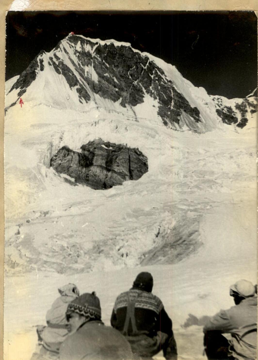
Photo No. 3.