Climbing Passport
Completed in the 1975 USSR Alpine Climbing Championship
Climbing class: High-altitude technical. Climbing area: Central Pamir, Bivachny Glacier. Climbing route: Peak Akhmad Donish (6665 m) via the South face. Climbing characteristics: height difference 2300 m, average steepness 73°, length of complex sections 1610 m (steepness 81°). Number of pitons used: rock - 357, ice - 13, bolted - 2. Total climbing hours - 90.5 hours. Number of bivouacs - 10 (excluding preparation day), including: lying down - 4 (all in one location - weather waiting), sitting - 6. Additionally, two lying down bivouacs on the summit - weather waiting. Team name: Leningrad City Sports Committee Team. Team members:
- Solonnikov Viktor Aleksandrovich - Master of Sports, captain, coach
- Grachev Andrei Borisovich - Master of Sports, participant
- Borzov Yuri Vyacheslavovich - Master of Sports, participant
- Vikulin Stanislav Aleksandrovich - Master of Sports, participant
- Smirnov Alexey Aleksandrovich - Candidate for Master of Sports, participant
- Rekeda Anatoly Aleksandrovich - Candidate for Master of Sports, participant
Climbing dates: August 17-31, 1975. Team's final position:
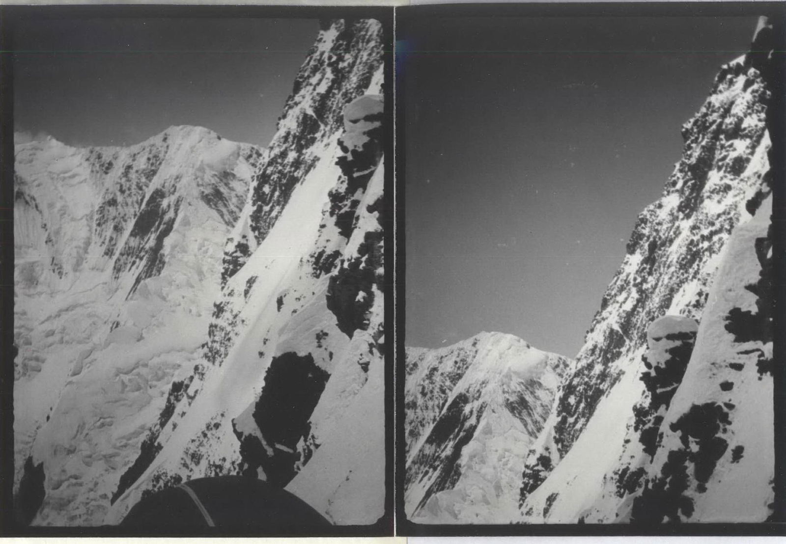
View of the upper part of the SW face of Peak Akhmad Donish (taken from the descent route).
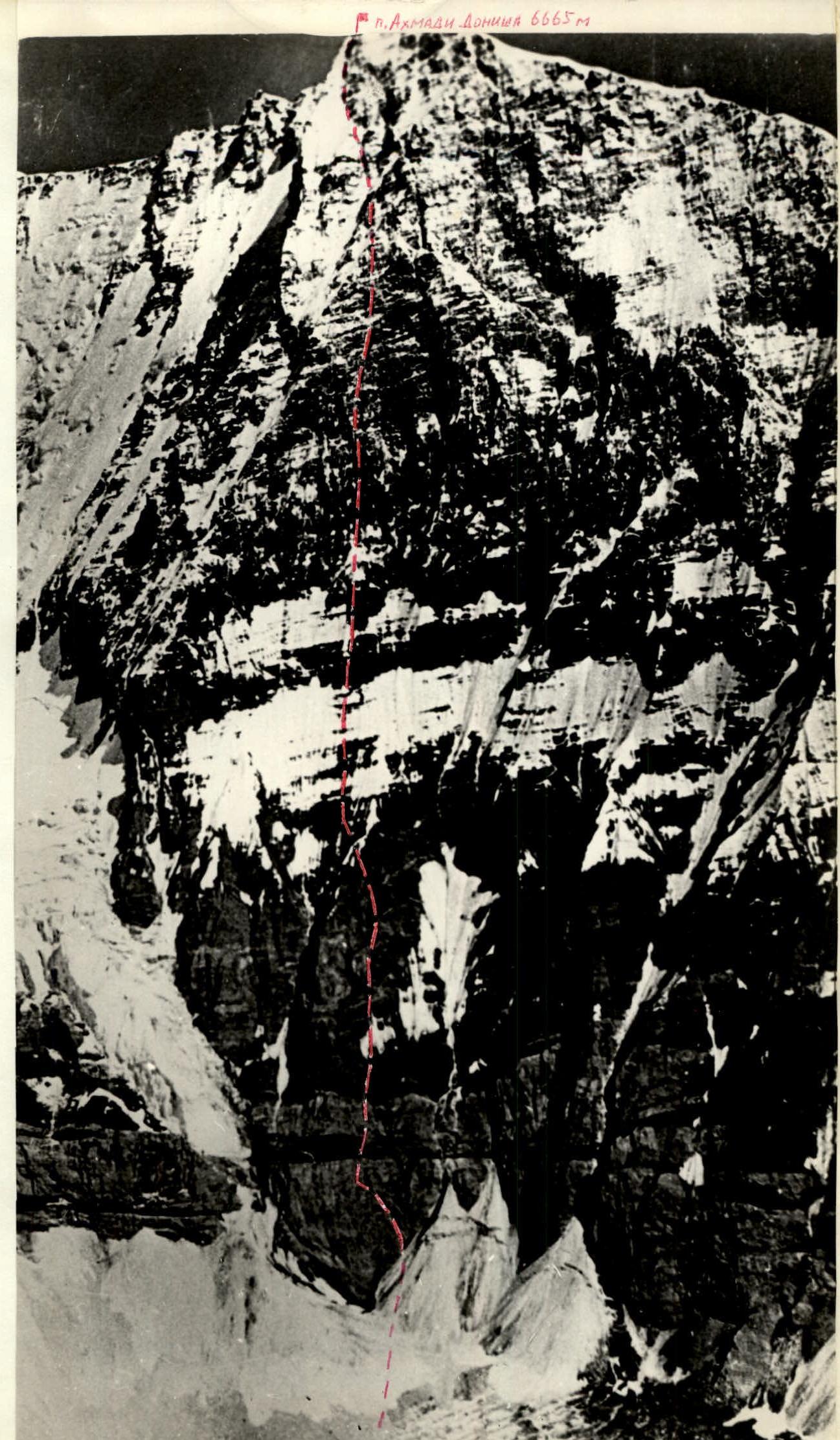
Photo 1. Peak Akhmad Donish (6665 m). South face.
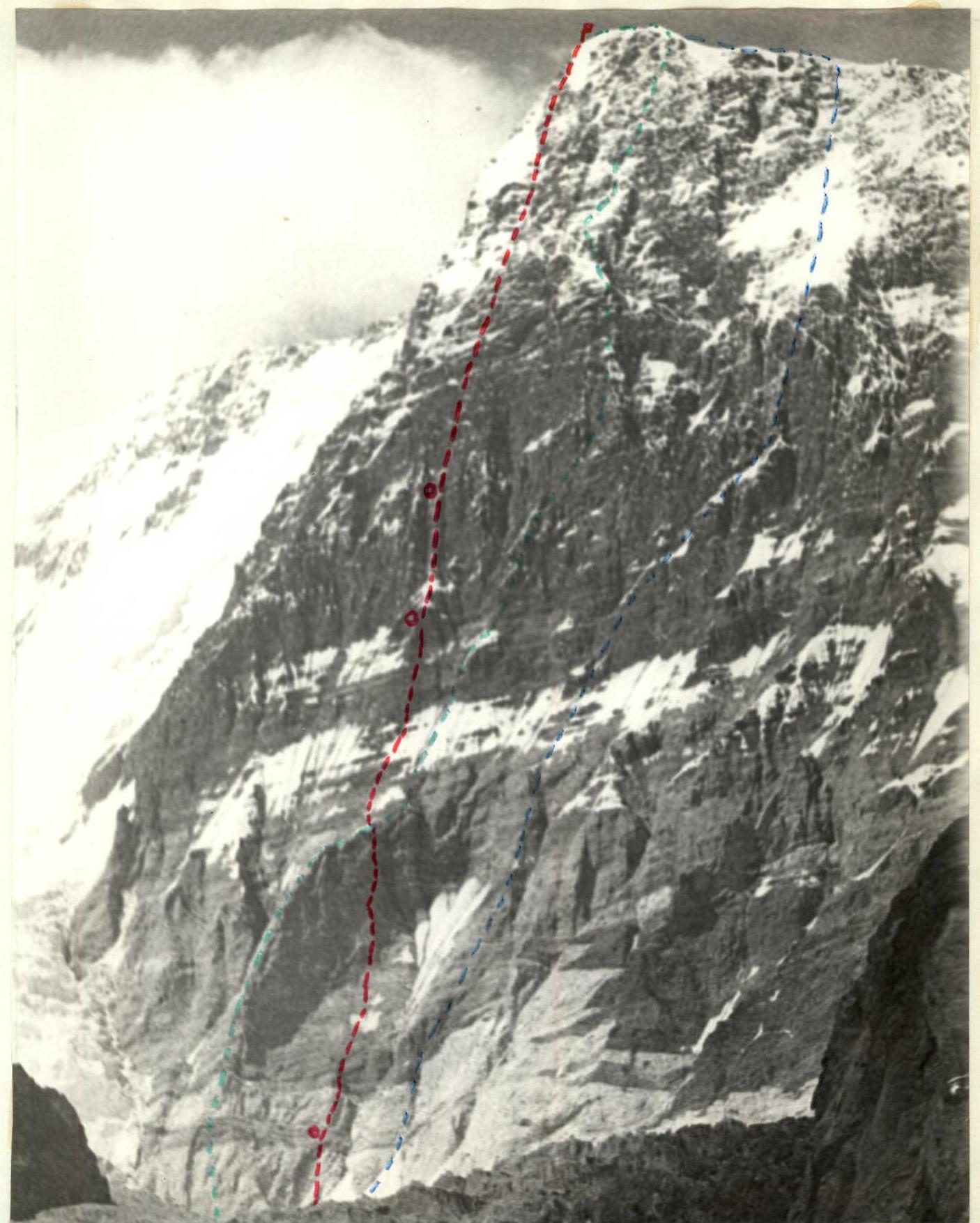
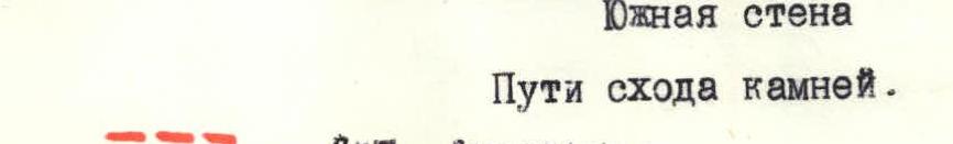
Photo 2. Peak Akhmad Donish (6665 m). South face. — route of the "Burevestnik" team, 1974 — route of the SCA team from Alma-Ata, 1975 — route of the Leningrad City Sports Committee team. — control points.
Brief description of climbing conditions in the Bivachny Glacier area
Climbing conditions in the Bivachny Glacier area are characterized by crumbling rock formations, presence of ice and snow on rock sections, large temperature fluctuations between day and night, and periods of bad weather with snowfall and blizzards. Bad weather cycles usually last 3-4 days, with possible temperature drops to -20 °C or lower. Most peaks in the area are above 6000 m. Conquering peaks like Peak Akhmad Donish (6665 m) requires high-altitude climbing experience and proper group preparation for working at high elevations in harsh conditions. Some peaks, including Peak Akhmad Donish, do not have a simple descent route, which further complicates the climb. Climbing in this area is an organizationally complex event, conducted in expeditionary conditions. Approaching the routes, particularly the South face of Peak Akhmad Donish, requires multi-hour transitions across broken glaciers, icefalls, scree, and snow slopes, as well as overcoming crevasses and more.
Team preparation and training exits
The team in the declared composition has been working together for many years. The preparation cycle is year-round. This year, in preparation for climbing the face of Peak Akhmad Donish, the team held a gathering in the Crimean Mountains, completing several complex climbs.
The team began work in the Bivachny Glacier area on August 5, 1975. The following preparation stages were conducted:
- August 6-7: first training exit and preliminary observation of the route;
- August 8-10: climbs of 3B and 5A category of difficulty;
- August 12-14: setting up a camp under the route, observation, and final route selection.
Results of route observation and final route selection
The goal of route observation was to determine the paths and patterns of rockfall.
In Photo 3, the main rockfall paths are indicated, with vertically hatched areas showing where rocks fall at intervals of 1-1.5 hours, and both vertically and horizontally hatched areas showing intervals of 10-15 minutes.
Rockfall activity typically starts between 9:00-10:00 AM and continues until 18:00-19:00.
Table 1 shows the average intervals between rockfalls for different points on the route, marked with letters:
- a
- b
- c
- d
on Photo 3
Table 1
| Route sections | 20:00–8:00 | 8:00–11:00 | 11:00–16:00 | 16:00–20:00 |
|---|---|---|---|---|
| a | 1 hr | 0.5 hr | 10 min | 0.5 hr |
| b | - | 1.5 hr | 1 hr 40 min | 1.5 hr |
| c | - | - | 2 hr | - |
| d | - | - | 2–3 hr | - |
Based on the observation results, it was decided to start the route via the right, rockfall-free part of the central "paw" - counterfort, rather than repeating the objectively hazardous lower section of the army team's route.
Photo 3. Peak Akhmad Donish (6665 m). South face. Rockfall paths. Legend: — ascent route — route of the SAVO team 1975 — route of the "Burevestnik" team 1974
The approach to the central part of the face is made by sharply turning left from the end of the counterfort "paw" towards the less rockfall-prone part of the "belt", and this section should be passed in the morning or evening. The middle part of the face is climbed via the bastion, avoiding the couloirs. The planned route is shown in Photo 4.
As seen from the rockfall pattern, with reasonable timing for passing individual sections ("b", "d"), the route is practically safe.
On the face, conventional landmarks and sections are identified (see Photo 3):
- Lower part - "paw"
- "belt"
- snow patch "bird"
- "Bastion"
- "Mirror"
Team composition according to the application and assault group
The team composition for climbing Peak Akhmad Donish according to the application: captain and coach - Solonnikov Viktor Aleksandrovich; participants:
- Vasiliev B.
- Grachev A.
- Solonnikov Vlad.
- Chunovkin G.
- Posessor L.
- Lazarev V.
- Borzov Yu.
- Vikulin S.
- Smirnov A.
- Rekeda A.
- Orlov B.
- Shalygin Yu.
The assault group was determined to be six people. Solonnikov Viktor Aleksandrovich - captain, Master of Sports. Participants:
- Grachev Andrei Borisovich, Master of Sports
- Borzov Yuri Vyacheslavovich, Master of Sports
- Vikulin Stanislav Aleksandrovich, Master of Sports
- Smirnov Alexey Aleksandrovich, Candidate for Master of Sports
- Rekeda Anatoly Aleksandrovich, Candidate for Master of Sports.
The observation group included: expedition leader Chunovkin G.A., Master of Sports;
- Zubakov V.G., Master of Sports
- Volkov V., 1st sports category
- Maragin V., 1st sports category
- Fedosov A., 1st sports category.
Tactics and route plan
The plan was to climb the face in five climbing days with preliminary processing of the lower part of the route. The planned bivouacs were:
- at the top of the rock "paw"
- at the foot of the rock "bastion" ("on the bird") - twice
- at the top of the rock bastion
- on the upper part of the "mirror"
- on the summit (see route sheet and Photo 4).
Possibly, an additional bivouac would be in the middle part of the rock "paw".
This is how the route variant turned out, however, severe bad weather forced the team to wait out for three days at the top of the rock "paw". The upper part of the route was climbed in two days (instead of one) in blizzard and severe frost conditions (Photo 4). Thus, in reality, the route required seven climbing days and one day of preliminary processing.
The planned route passage assumed a speed of 300-400 m per day. This is possible if rucksack hauling is not used or minimized. We understood that using the usual rucksack hauling method over 80 m would not be feasible due to the highly crumbling nature of the rocks.
It was decided:
- To minimize the weight of rucksacks.
- To use rucksack hauling only in exceptional cases on short sections.
To lighten the rucksacks, a six-person team was chosen. The first climber worked without a rucksack throughout the route.
Whenever possible, team members moved in galoshes. However, due to weather conditions on the middle and upper parts of the route, this type of footwear was used only sporadically. On the section of gentle rocks between the rock "paw" and the "Bastion" ("belt"), which is rockfall-prone during the day, preliminary processing was used, allowing this section to be passed quickly and at a safe time. Preliminary processing was also used on the upper part of the face (when passing the "mirror"), as it is practically impossible to set up a comfortable bivouac on this part of the route (even a sitting one), and a significant section (over 400 m) needs to be covered in a day.
To ensure a high pace of route passage, a rotation of the lead climber was planned. All measures regarding the order of advancement on the route, interaction, and the planned wall passage were largely implemented.
Description of the ascent by days
First day - August 16, 1975. The group consisting of:
- Solonnikov Vict.
- Grachev A.
- Borzov Yu.
- Vikulin S.
- Smirnov A.
- Rekeda A.
left the base camp and arrived at the camp under the South face of Peak Akhmad Donish at 17:00.
Second day - August 17, 1975. The trio Grachev A., Borzov Yu., and Rekeda A., carrying all 300 m of rope and "hardware", set off to process the route at 8:00. The first meters on the rock presented significant difficulties, requiring the use of pitons as footholds (sect. R0–R1, Photo 8). On the second rope, overhanging sections were encountered. The path led under a huge cornice. Here, on a small ledge, rucksack hauling was necessary. This was the first control point (sect. R1–R2). Further, a traverse and ascent via steep slabs followed. These 160 m required over 5 hours of work, and the team was climbing lightly, in galoshes. The route continued up more gentle (75°) sand-covered rocks. Climbing was very tense, with no visible holds. Feet and hands struggled to find support under the sand layer. It was necessary to search for cracks to hammer in reliable pitons. Finally, the "sandy" belt was passed. An internal angle led upwards. The rocks were strong, but at the top of the angle, a huge stone "plug" and a pile of "live" stones were encountered. It was necessary to be extremely cautious. Above the internal angle, a slightly overhanging wall with a thin crack followed. The path went straight up via ladders (sect. R5–R6) and further - again sand-covered "soft" rocks. Holds often crumbled in hands. Upward movement was slow. 300 m was covered by 20:00. All ropes were hung, but less than half of the "paw" was passed. It was clear that reaching the top of the "paw" the next day would not be possible; a sitting bivouac would be necessary somewhere in the middle. Water was carried from the base camp as there was no ice or snow on the route. 12 climbing hours were spent covering 300 m of the route, with 52 rock pitons hammered. The weather was cloudy all day, and further deterioration was expected. However, the wall "worked" significantly less intensely than usual. Although the route was not directly exposed to rockfall, it was still more pleasant when there was no rockfall noise around.
Third day - August 18, 1975. We started at 7:00 and began moving along the processed sections. On sections R0–R3, R4–R6, rucksack hauling was necessary. Their weight was small (only 5 rucksacks) - 7-8 kg each, but hauling still made progress faster. Everyone wore galoshes. The pace was quite high, and by 12:00, the processed sections were completed. Further up, a belt of gentle (70°) yellow rocks followed; again, sand on the holds, and the holds were not strong. This was a very psychologically unpleasant section, especially for the first climber. He seemed to be "floating" on this sand, feeling for invisible holds (sect. R7–R8). This lasted for 100 m. Then more steep and strong rocks followed, although with many "live" stones. An internal angle, a wall, and a cornice were passed; the cornice was traversed on ladders; a wide chimney, 10 m long, was climbed (sect. R9–R10). Above, under an overhang, the route turned right and continued up through a small cornice. Then, an almost vertical wall with soft, crumbling holds followed (sect. R10–R11). Another 60 m of slabs with "live" stones, and a sitting bivouac was set up on a small ledge. It was already 21:00. A long working day - 14 climbing hours - was over. 37 rock pitons were hammered, and 580 m was covered from the start of the route (including 300 m processed the day before). The top of the "paw" was still 200 m away. A small amount of ice was melted to make tea. The next day would start without water. At 20:00, there was contact with observers, who could still see us. The bivouac was sitting, in different places, but we managed to rest. The whole day was cloudy, but it was still possible to move, and the rocks were dry.
Fourth day - August 19, 1975. We started at 10:00. The sun was visible in the morning, but then everything clouded over again. The duo Borzov–Rekeda worked ahead. A несложная разрушенная стенка (sect. R12–R13) and a long, wide внутренний угол followed. The rocks were strong, but steep, and there were not many holds (sect. R13–R14). At the top of the angle, a cornice was encountered. The route traversed right, and another внутренний угол led up. Here, there were many "живые" камни, and the rock was brittle (sect. R15–R16). It was necessary to climb with rucksacks everywhere. Finally, via steep slabs with "живые" камни (sect. R16–R17), the top of the "лапа" was reached. 17:00. 200 m was covered. 28 rock pitons were hammered.
On the very top of the "лапа", there was an army team's bivouac - this is where their route was intersected. A bivouac was also set up on the "лапа", but slightly lower, as their spot was exposed to rockfall. It was necessary to work hard, but the tents were set up fully.
While the bivouac was being set up, the duo Grachev–Solonnikov processed the further path through the "пояс".
It was evening, and the wall was relatively calm, with rocks falling only occasionally down the couloirs (sections "а" on Photo 3). In 3 hours, 200 m of ropes were hung. The rocks were not very steep - 67–75°, with the path following an внутренний угол, then wet slabs with small overhanging sections (sect. R17–R20).
Another 80 m of slippery rocks, and the steepness increased. Upwards led:
- a щель,
- a small cornice.
Ahead, about 40 m away, a нависающий пояс was visible. It reliably protected from rockfall. The duo descended. During processing, 21 rock pitons were hammered on 200 m. The mood was cheerful. Everyone was eager to continue. The next day, it was necessary to reach the "птица", which was another 250–300 m away. Communication with observers was excellent. The wall was directly above us; it seemed to be overhanging, looking very imposing and intimidating (Photo 7).
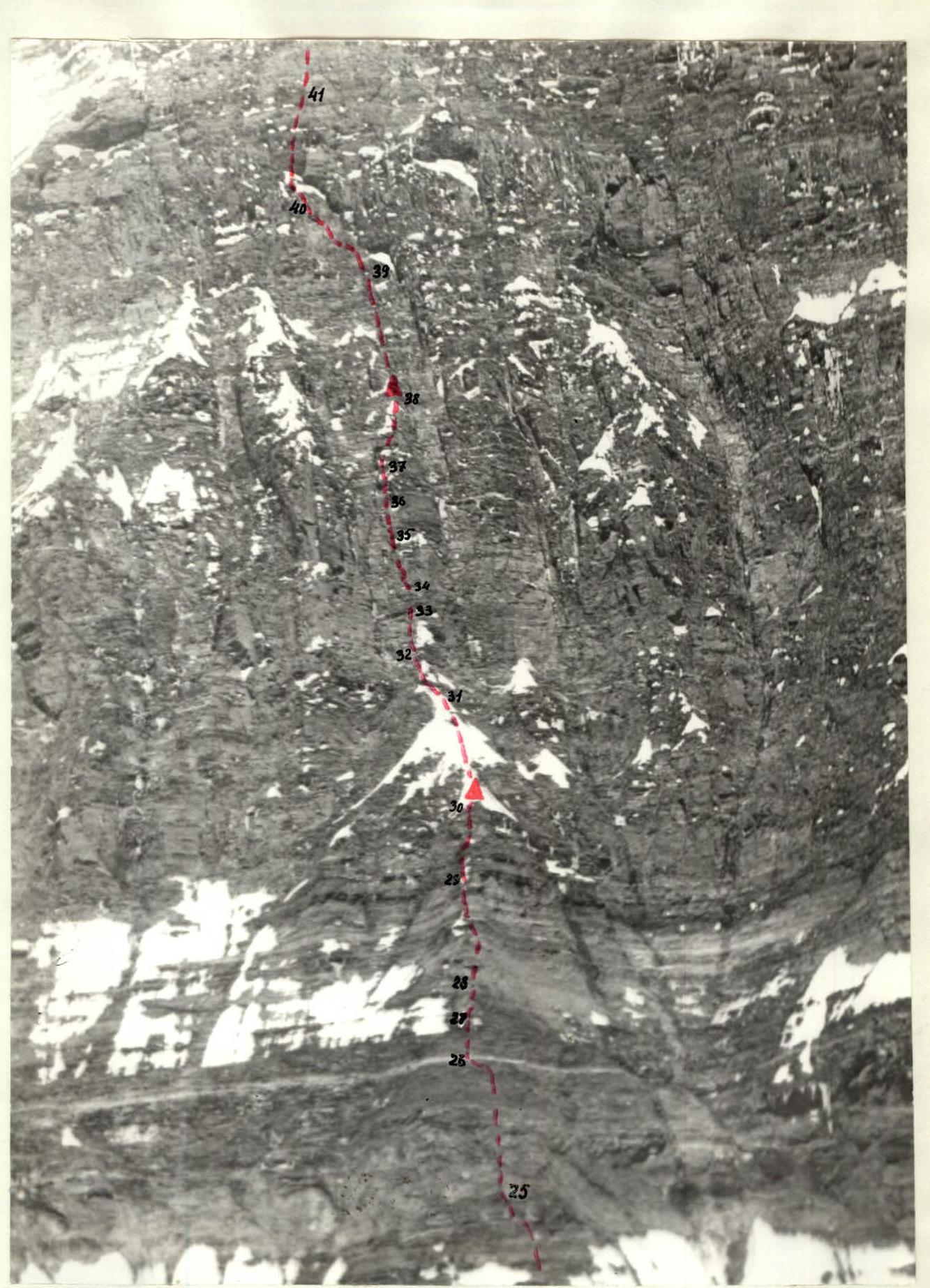
Photo 7. Middle part of the route ("бастион").
Fifth day - August 20, 1975. In the morning, we woke up to strong wind. Sleet was pounding against the tent. There was no question of setting out. By evening, 20 cm of snow had fallen. It was cold (from –15 to –20 °C). Food was limited - 180 g per person per day. Sublimated meat was a lifesaver. The wall was intimidating to look at. Our ropes were not visible - everything was covered in snow (Photo 7A).
Sixth day - August 21, 1975. In the morning, it was cloudy, but there was no snow. We set out at 11:00. The ropes were icy. The rocks were covered in snow and ice. The first climbers went above the processed ropes for another 100 m. Holds were not visible - everything was under snow, and the steepness was 67–85°, with many "live" stones. First, a wall, then an обход карниза по микрозацепкам (sect. R22–R23, R23–R24). A blizzard began. On the next 100–150 m, there were no suitable platforms. Not even a ledge for a sitting bivouac was available. Fortunately, the lower ropes were still not removed. We quickly descended to the previous bivouac. Now we had 300 m of ropes hung - all we had. 100 m was covered in 4 hours, with 17 pitons hammered. Everyone got quite wet. Observers reported that the forecast was not good: cloudiness, snow.
Seventh day - August 22, 1975. Snow continued to fall. We waited it out. Thankfully, the bivouac was lying down. By evening, it cleared up. The wall was white. Food was 180 g per person per day.
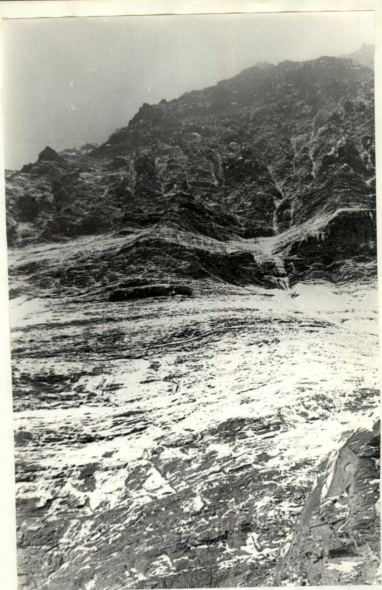
Photo 7A. Middle part of the route after snowfall.
Eighth day - August 23, 1975. In the morning, finally, the sun came out. Everything was bright and glistening. We started the ascent at 10:00 along the icy ropes. It was tough, but the snow melted quickly. By 13:00, the processed sections were completed.
It was daytime, and the wall was still "silent" - everything was frozen in snow and ice. It was cold, although the snow melted quickly in the sun. We wore crampons - galoshes were too cold.
Upwards led icy slabs, then an внутренний угол filled with "live" stones (sect. R24–R25). Rucksack hauling was necessary, and rocks fell, but to the side. An внутренний угол, turning into a chimney, led under a powerful cornice.
Under the cornice, a неприятный траверс followed to an upwards-leading нависающий камин (sect. R25–R26, R26–R27, Fig. 2, Photo 22). Pitons were used as footholds, and rucksacks were hauled.
Further, more gentle плиты 70° (sect. R27–R28) and another steep wall followed, with rocks being нагромождения "живых" камней. Climbing was very difficult and tense. Finding a spot to hammer in a reliable piton was a significant challenge. The first climber wore galoshes. Feet were freezing. Progress was slow. Another small wall, a отвесный камин (sect. R29–R30), and a vertical ice section followed. A screw piton was used, steps were cut, and the first climbers reached the крутой снежно-ледовый гребешок - the tail of the "птица".
Deep twilight, 21:00. Small platforms were cut in the ice - sitting bivouacs. On the rocks, a second control point was set up.
In 11 climbing hours, 300 m was covered above the processed sections. 39 rock and 1 ice piton were hammered. The tense day was over. The sky was clear, with a frost of over –20 °C. Above us were the отвесные скалы "бастиона", and above them, the upper part of the "зеркала" was visible (Photo 7).
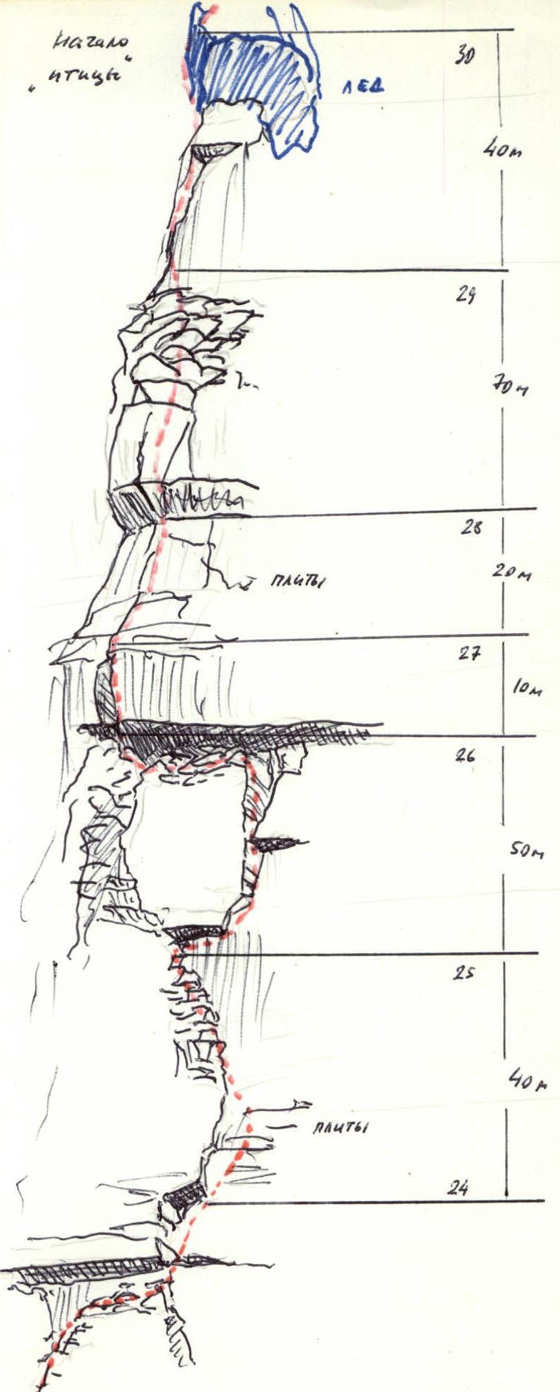
Fig. 2. Beginning of the "бастион" (up to "птица").

Fig. 3. "Бастион" (above us, the top of "зеркала" is visible - appearing as a smooth and overhanging upper wall). We had covered almost half of the route in terms of length. There were no news from the observers via radio. The bivouac was not very comfortable, and rest was not good.
Ninth day - August 24, 1975. We set out at 9:00. The sun was shining. The first climber wore crampons. The ice was not very complex, with insurance via ice pitons. After 80 m, rocks began. Borzov replaced Grachev.
- Via wet slabs, rocks with ice, the movement was upwards to the left for 40 m (sect. R31–R32).
- Further up, a залитый льдом отвесный внутренний угол followed, with icicles. Pitons were used as supports (sect. R32–R33).
- Ahead, a нависающая стенка followed, and galoshes were worn. Ladders were hung.
- At the top, a pile of "live" stones, and further - a отвесный внутренний угол (sect. R34–R35).
- Climbing was technically very complex even in galoshes: holds were small, and overhanging sections were encountered.
- Movement was in a "stacked" formation. The rock was unreliable.
- It was necessary to climb with rucksacks and haul them for 10–15 m.
- In some places, it was necessary to move on a freely hanging rope.
- After a section of плиты (sect. R35–R36), a залитый льдом внутренний угол followed (sect. R36–R37).
- A small траверс по льду with step-cutting and a wide внутренний угол with snow, ice, and "live" stones led to a гребешок at the top of the контрфорс.
Here, in the stones, a sitting bivouac was carved out, a third control point was set up, and the route was processed further. While the bivouac was being set up, the trio Vikulin, Grachev, Borzov climbed another 190 m and hung ropes.
- Ahead, 400 m of отвесная стена followed - there was no place to bivouac.
- This section needed to be covered the next day, and as much processing as possible was done today.
- Above the bivouac, 80 m of steep плиты led up. Overhanging sections were encountered.
- Further, the wall was crossed by a карниз. It was possible to обойти it on the left - траверс под карнизом for 40 m (sect. R39–R40).
- And up via an внешний угол for another 40 m. The rocks had small holds and were almost отвесные (sect. R40–R41).
- The processors wore galoshes.
- Ahead, a расщелина filled with ice followed - 20 m up on crampons with ice pitons (3 pcs., sect. R41–R42).
Processing took 4 hours, and a total of 11 climbing hours for the day. 280 m was covered, and another 190 m was processed. 59 rock and 3 ice pitons were hammered. The скалы "бастиона" were passed, and part of the "зеркала" was processed. The day was very tense, and the team was significantly fatigued. Sitting bivouacs were also exhausting. Radio contact with observers was excellent - they had moved to the base camp and were watching us through a telescope.
Tenth day - August 25, 1975. We set out early, at 7:00. Today, we needed to attempt to reach the top of the "зеркала". We were in a fighting mood. We covered the processed sections by 10:00. On section R39–R40, rucksacks were hauled. After the ледовый камин, a заглаженный, отвесный внутренний угол followed (sect. R42–R43, Photo 30). Galoshes were worn, ladders were used, and rucksacks were hauled. Team members moved on a freely hanging rope. Further, a отвесная стенка followed. A траверс по мелким зацепкам to the right above the нависающий пояс was psychologically very unpleasant; below, 1.5 km down, was the ледник. Now, upwards. The rocks were отвесные and composed of layered soft пород - like a слоёный пирог. Holds broke, and pitons did not hold well. This lasted for 40 m (sect. R44–R45). Above, a карниз and a нависающая стенка followed, with ladders used and rucksacks hauled (sect. R45–R46, Photo). Ahead, to the right - a стенка and a нависающий внутренний угол - again ladders and rucksack hauling. One bolted piton was used (sect. R47–R48, Photo 31–32). It was already 15:00, and the top of the "зеркала" was still far away. Upwards to the right, a щель between the main wall and a huge отслоившаяся глыба led (sect. R48–R49), and further - first a нависающий внутренний угол. Here, another bolted piton was used (sect. R49–R50). The wall became more gentle, but there were even more "live" stones.
Via a wide внутренний угол, we gained over 70 m and, after another 40–50 m of steep crumbling rocks, finally reached the top of the "зеркала". It was getting dark. 21:00. We set up a semi-lying bivouac. Upwards, a разрушенный контрфорс led. The next day, we would attempt to reach the summit.
In 14 climbing hours, 550 m was covered (including 190 m processed the day before). 60 rock pitons, 2 bolted pitons were hammered.
This was the most difficult and tense day of the ascent. Hopefully, it would be easier further on.
Eleventh day - August 26, 1975. We set out at 10:00. It was cloudy. Via несложным разрушенным скалам and snow, we gained 80 m. Snowfall began, and wind picked up. Visibility was 50–70 m. Via заснеженным скалам, we slowly moved forward. In normal weather, these would be rocks of 4Б–5А category of difficulty. Now, with holds not visible, everything covered in ice and snow, movement was extremely complicated (sect. R53–R54, Photo 39, 40).
We crossed a ледово-снежный кулуар. We moved on crampons with step-cutting; small лавинки of fresh snow flowed down the кулуар.
Further up, via крутым скалам. Snow streams flowed, it was very cold, with a piercing wind and snow. Holds and трещины for pitons were not visible. Gloves could not be removed - hands froze instantly.
After 50 m (sect. R55–R56), we decided to set up a bivouac. With great difficulty, we established a "pamirka" and all six of us climbed in. The tent was covered in snow, and we had to dig it out.
17:00. In 7 climbing hours, 240 m was covered, with 22 rock and 2 ice pitons hammered. We warmed up. The bivouac was uncomfortable but warm. We still had 300 m to the summit. We reported our situation via radio. It turned out that it was also snowing below. So, it had really cooled down significantly.
Twelfth day - August 27, 1975. We set out at 10:00. Snow was falling. We crossed a ледово-снежный кулуар and then climbed up steep плиты. Everything was in snow and ice. Visibility was 50 m. Strong wind, blizzard. Upwards, a ледовый склон followed, covered with a 5–10 cm layer of snow. We climbed on crampons with step-cutting, using rock pitons for insurance, which we managed to hammer into occasional rock outcrops, and ice pitons. The steepness of the ice increased to 70° - this was an ice-rock wall. In conditions of continuous snowfall, hurricane-force wind, and severe frost, this was a section of maximum difficulty (sect. R58–R59). Another 30 m via валунам, ice, rocks (wall, внутренний угол) - sect. R59–R60, and we reached the saddle. Further, 40 m via an внутренний угол, turning into a chimney, and finally, the summit. Visibility was 15–20 m. We retrieved the army team's note, left by a group led by V. Smirnov. We descended 30 m and set up tents on a small snow-filled мульда on the eastern ridge. The wind was picking up. In 7 hours 30 minutes, 300 m was covered, with 22 rock and 7 ice pitons hammered. Food was running low, but the wall was climbed, although it was a tough challenge. We received congratulations via radio.
Thirteenth day - August 28, 1975. The whole day, from morning, was marked by hurricane-force wind. Visibility was no more than 20 m. We held onto the tent. By evening, the wind had subsided slightly.
Fourteenth day - August 29, 1975. At night, the wind started to violently rip the tent again. We held onto it all night, but by morning, the tent was torn in several places. We had to repair the tears in the wind. Finally, by 11:00, the wind subsided slightly, and we began our descent along the eastern ridge, and then down to the north:
- 8 спуск по 80 м,
- спуск в верховья Ледника Одиннадцати.
Fifteenth day - August 30, 1975. We set out at 11:00 and by evening passed all the steps of the ледопада. We bivouacked on the морене, within half an hour's walk from the Бivachny Glacier.
Sixteenth day - August 31, 1975. By 10:00, we returned to the base camp on the морене of the Бivachny Glacier. The ascent was complete. The ascent to the summit took eleven days, including one day of processing. Eight climbing days were required, and three days were lost due to bad weather. The length of the route exceeded 2.5 km. The sections climbed, with rare exceptions, were of 5Б–6Б category of difficulty.
Assessment of the team's actions
Team captain Viktor Solonnikov. The team was well technically and physically prepared. Participants had experience in both technically complex and high-altitude climbs. The team was characterized by complete mutual understanding among participants and their interchangeability, i.e., the ability to perform any role within the group: to climb first, last, haul rucksacks, etc. Participants were equally skilled on rock and ice terrain, able to climb rocks in galoshes, in crampons, on ice with crampons, and on snow in crampons.
Despite poor weather conditions and the challenging state of the route, the team maintained a high pace, covering 300–400 m per day on extremely complex terrain. It is worth noting the high moral and volitional qualities of team members, which enabled them to successfully complete the ascent despite:
- bad weather,
- forced waiting periods,
- frost,
- wind,
- poor visibility, etc.
Team captain
Additional data on the route
The route to the summit of Peak Akhmad Donish (6665 m) via the South face is a route with a height difference of over 2300 m and a length of more than 2.5 km. The steepness of the route is over 70°. The length of the most complex sections (5Б–6Б category of difficulty) is 1610 m at a steepness of about 80°. The route to Peak Akhmad Donish is one of the longest wall routes in its class. It exceeds in length such giant walls as the North face of Peak F. Engels, walls on peaks Moskovskaya Pravda, Tajikistan, Pathhor, Lyap-Nazar, OGPU, Komacademy, and others. Moreover, the wall of Peak Akhmad Donish is not inferior to the listed routes in complexity and even surpasses most of them. The route is particularly complicated by the high degree of rock destruction at significant steepness, as well as sections of soft пород with unreliable, crumbling holds. Additional difficulties arise from the increased rockfall hazard of the wall, requiring careful route selection and development of group movement tactics. The route via the center of the left "зеркала" of the South face is the steepest, technically most complex, and safest of the routes climbed, considering the start via the right, rockfall-free part of the "лапа" and passage of the "пояс" between zones of active rockfall. This path passes through the steepest part of the wall - the center of the left "зеркала" and leads directly to the summit, featuring combined and ice sections in the upper part of the route that require the group to possess ice climbing techniques.
Team captain and coach Solonnikov V.A. Participants: Grachev A.B. Borzov Yu.V. Vikulin S.A. Smirnov A.A. Rekeda A.A.


