
I. Brief geographical description and climbing characteristics of the traverse
The peaks of the traverse are located on the northwestern Pamir. In its northern part, the meridional ridge of the Pamir - the Academy of Sciences Range - forks, giving a powerful branch to the west, which ends at Peak E. Korzhenevskaya. The fork is formed by the massif of Peak Voroshilov, representing a more than 3-kilometer uplift in the form of a ridge, fluctuating in height from 6666 m to 6500 m.
The ridge has significant ruggedness (from 7105 m to 5300 m), but nevertheless represents a single massif both geographically and in mountaineering terms.
The massif is bounded by two powerful glaciers (Ayu-Dzhilga and Moskvin) and separates two large valleys (Ayu-Dzhilga and Fortambek).
The peaks within the massif had already been conquered via the simplest routes:
- Peak Voroshilov from the east;
- Peak Chetyrekh from the southwest;
- Peak E. Korzhenevskaya from the west and south.
No attempts had been made to traverse the massif.
II. Brief description of the ascent conditions in the area
a) Terrain features.
- The rocks forming the peaks of the ridge are very loose, producing an abundance of scree and moraines.
- Nevertheless, the slopes of the entire massif, dropping to the east (into the Ayu-Dzhilga valley), have a large number of rock faces.
- The ridge is heavily rugged and has a height fluctuation of almost 2000 m (from 5300 m to 7105 m).
The cross-section of the ridge has the shape of a sharp knife, with an abundance of snow cornices hanging to the east (towards the Ayu-Dzhilga valley).
Additionally, there are a significant number of rock "gendarmeries" or rocky outcrops on the snow-ice ridge of the massif.
b) Weather conditions. Being located to the west of the Academy of Sciences Range, which is a natural climatic barrier in the Pamir, the traverse area is one of the most humid regions of the Pamir. Moreover, being in close proximity to the saddle between Peak Voroshilov and Peak Kalinin, it is dominated by constant westerly winds, sometimes reaching significant strength.
Thus, the traverse area is characterized by:
- Unstable weather;
- Significant precipitation;
- Strong winds;
- Low temperatures due to its significant elevation above sea level.
c) Remoteness. The Ayu-Dzhilga valley is a day's walk (with one river crossing using a hydrological cradle over the Muk-Su river) from the Altyn-Mazar weather station and two days' walk from the district center Dorot-Kurgan, located in the Alai Valley. Movement to these populated areas is along a trail.
The nearest mountaineering base is located near Peak Lenin in the Alai Valley, accessible by car from Dorot-Kurgan.
d) Exploration of the area. The Ayu-Dzhilga valley had not been visited by climbers before our expedition. Currently, members of the main and auxiliary teams have made several first ascents to peaks of 3rd to 5th category difficulty in the valley.
III. Reconnaissance and supply trips
a) In the previous year, 1965, from July 1 to July 10, the duo Budanov P.P. – Borisenok O.N. made a reconnaissance trip to the Ayu-Dzhilga valley and ascended the valley to the glacier cirque.
The duo reconnoitered the traverse object and approaches to it.
b) From July 26 to July 31, 1966, a supply trip was made under Peak E. Korzhenevskaya. The group consisted of nine people:
- Budanov P.P.
- Agranovsky G.L.
- Ilyinsky G.Ya.
- Kletsko K.B.
- Kletsko B.B.
- Roshchin I.N.
- Ustinov D.K.
- Konoplev K.A.
- Shestko V.I.
IV. Organizational and tactical plans
Considering the group's size (nine people - three tents, three roped teams) and the significant complexity of the route (sharp, steep rock and ice ridges and wall sections), it was decided to organize three teams of three, capable of autonomously solving all tasks and maintaining close communication with each other. The correctness of this decision was confirmed by experience.
Having experience in technically complex ascents and high-altitude traverses, the group adopted a tactical plan of gradual siege of the targeted objectives.
No changes were made to the previously planned plan.
No new equipment, apart from previously used samples of increased strength made of titanium, was used on this traverse.
V. Composition of the storm group and its adjustments
The application to the main judging panel listed ten main candidates for participation in the traverse:
| Budanov P.P. | — team leader |
| Agranovsky G.L. | — deputy leader |
| Ilyinsky G.Ya. | — participant |
| Kletsko K.B. | — participant |
| Kletsko B.B. | — participant |
| Roshchin I.N. | — participant |
| Ustinov D.K. | — participant |
| Konoplev K.A. | — participant |
| Kolchin A.A. | — participant |
| Shestko V.I. | — participant |
Following training ascents and medical examinations, nine people embarked on the traverse. Shestko V.I. was not cleared for the ascent by the doctor.
VI. Evaluation of the storm group's actions on the traverse
Given the specificity of our organizational and tactical scheme, which granted autonomy to the teams under centralized leadership and coordination, it is easier to objectively evaluate the work of these teams rather than each team member individually.
-
1st roped team–tent: Budanov – Agranovsky – Kolchin. The team consists of tactically and technically mature athletes, who performed the majority of the snow-ice work, tactical decisions, overall leadership, and coordination of the entire group. The athletes successfully completed their tasks.
-
2nd roped team–tent: Kletsko K. – Kletsko B. – Roshchin. The team consists of athletes with extensive experience in technical ascents, well-prepared physically and tactically. The team handled a significant portion of tasks on rocky terrain. The athletes successfully completed their tasks.
-
3rd roped team–tent: Ilyinsky – Ustinov – Konoplev. Participating in numerous USSR mountaineering championships and making independent ascents, the athletes gained sufficient experience and successfully handled the tasks assigned to them.
VII. Data on the auxiliary group
The auxiliary group consisted of 3 people:
- Agranovskaya L.S. — group leader, cook, Master of Sports.
- Borisenok O.N. — radio operator, 2nd category.
- Zakharenko G.I. — doctor, 2nd category.
VIII. Additional data
Based on our modest experience in high-altitude ascents and traverses, and especially analyzing the traverse completed, the group would like to state the following:
- Considering the significant time spent by the group at high altitudes (above 6000 m), we strongly recommend periodic medical examinations of participants by someone sufficiently medically qualified.
In our group, 8 examinations were conducted throughout the expedition, both in the base and storm camps, as well as on the traverse route (3 times out of 8). The examinations were conducted by p.m.s. Ilyinsky G.Ya., who recently graduated from the Institute of Physical Culture.
- Remembering the enormous physical loads associated with a large volume of work at significant altitudes, we propose paying special attention to the physical preparation of ALL team members without exception, to ensure interchangeability during the march, thereby avoiding overloading individual team members and maintaining a good pace.
- Considering the already significant complexity of movement at high altitude, the team strongly recommends simplifying equipment (by manufacturing titanium pitons, household equipment, etc.) and food supplies (by manufacturing rations and using concentrates).
These recommendations are not new but are sometimes forgotten when deciding the main question — whether or not to proceed with the event.
 5th section. Exit to the rocky ridge.
TABLE OF MAIN CHARACTERISTICS OF THE PEAK VOROSHILOV - PEAK E. KORZHENEVSKAYA TRAVERSE ROUTE.
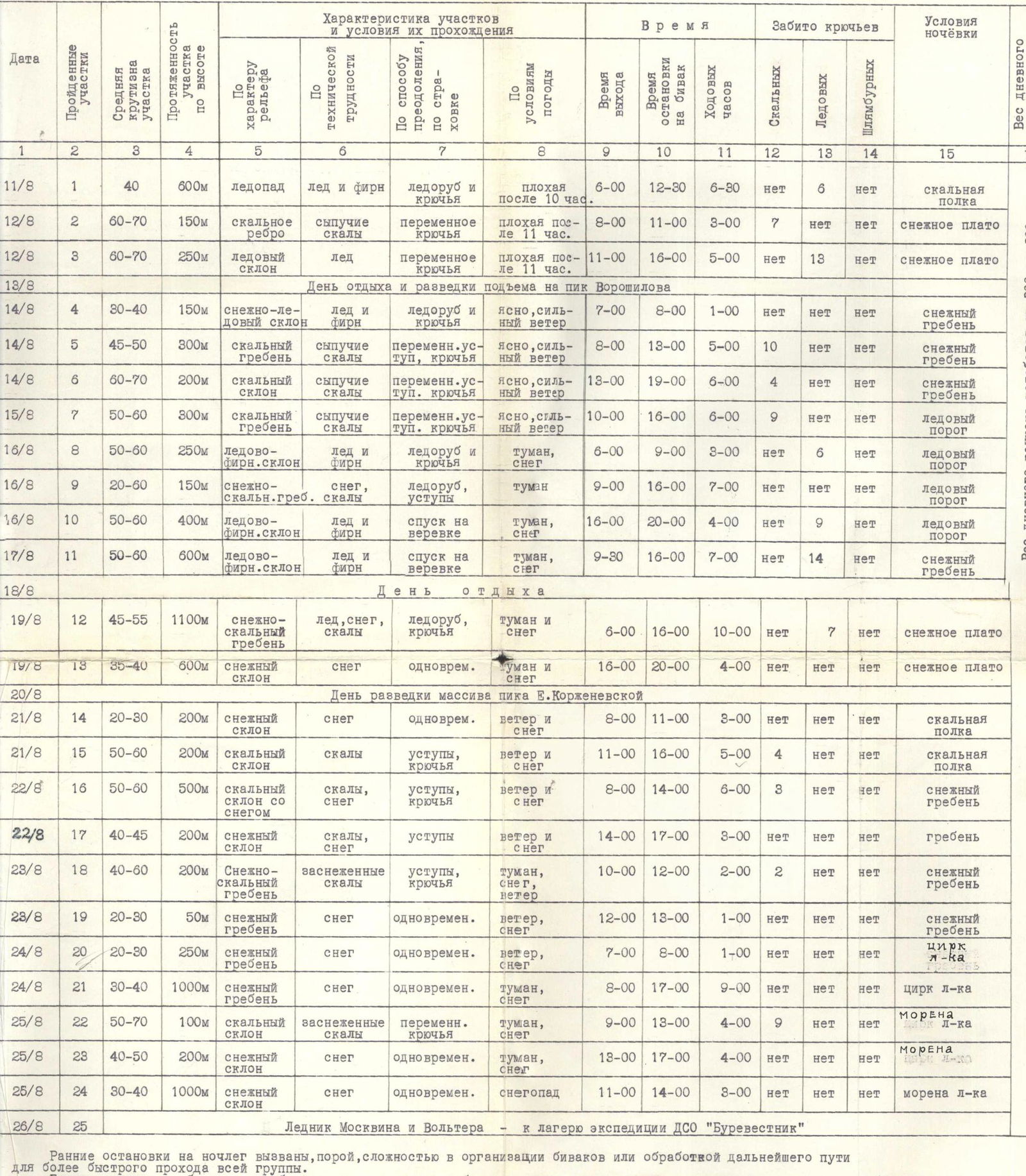
| Date | Sections | Covered sections | Characteristics of sections and conditions of passage | Time | Pitons driven | Camping conditions | Weight of daily ration |
|---|---|---|---|---|---|---|---|
| By terrain | By technical difficulty | By method of passage | By weather conditions | Start | |||
| 11/8 | 1 | 40 | 600 m icefall | ice and firn | ice axe and pitons | poor after 10:00 | 6:00 |
| 12/8 | 2 | 60–70 | 150 m rocky ridge | loose rocks | variable pitons | poor after 11:00 | 8:00 |
| 12/8 | 3 | 60–70 | 250 m ice slope | ice | variable pitons | poor after 11:00 | 11:00 |
| 13/8 | Rest and reconnaissance day for ascent to Peak Voroshilov | ||||||
| 14/8 | 4 | 30–40 | 150 m snow-ice slope | ice and firn | ice axe and pitons | clear, strong wind | 7:00 |
| 14/8 | 5 | 45–50 | 300 m rocky ridge | loose rocks | variable ledges, pitons | clear, strong wind | 8:00 |
| 14/8 | 6 | 60–70 | 200 m rocky slope | loose rocks | variable ledges, pitons | clear, strong wind | 13:00 |
| 15/8 | 7 | 50–60 | 300 m rocky ridge | loose rocks | variable ledges, pitons | clear, strong wind | 10:00 |
| 16/8 | 8 | 50–60 | 250 m ice-firn slope | ice and firn | ice axe and pitons | fog, snow | 6:00 |
| 16/8 | 9 | 20–60 | 150 m snow-rock ridge | snow, rocks | ice axe, ledges | fog | 9:00 |
| 16/8 | 10 | 50–60 | 400 m ice-firn slope | ice and firn | descent on rope | fog, snow | 16:00 |
| 17/8 | 11 | 50–60 | 600 m ice-firn slope | ice and firn | descent on rope | fog, snow | 9:30 |
| 18/8 | Rest day | ||||||
| 19/8 | 12 | 45–55 | 1100 m snow-rock ridge | ice, snow, rocks | ice axe, pitons | fog and snow | 6:00 |
| 19/8 | 13 | 35–40 | 600 m snow slope | snow | simultaneous | fog and snow | 16:00 |
| 20/8 | Reconnaissance day of Peak E. Korzhenevskaya massif | ||||||
| 21/8 | 14 | 20–30 | 200 m snow slope | snow | simultaneous | wind and snow | 8:00 |
| 21/8 | 15 | 50–60 | 200 m rocky slope | rocks | ledges, pitons | wind and snow | 11:00 |
| 22/8 | 16 | 50–60 | 500 m rocky slope with snow | rocks, snow | ledges, pitons | wind and snow | 8:00 |
| 22/8 | 17 | 40–45 | 200 m snow slope | rocks, snow | ledges | wind and snow | 14:00 |
| 23/8 | 18 | 40–60 | 200 m snow-rock ridge | snow-covered rocks | ledges, pitons | fog, snow, wind | 10:00 |
| 23/8 | 19 | 20–30 | 50 m snow ridge | snow | simultaneous | wind, snow | 12:00 |
| 24/8 | 20 | 20–30 | 250 m snow ridge | snow | simultaneous | wind, snow | 7:00 |
| 24/8 | 21 | 30–40 | 1000 m snow ridge | snow | simultaneous | fog, snow | 8:00 |
| 25/8 | 22 | 50–70 | 100 m rocky slope | snow-covered rocks | variable pitons | fog, snow | 9:00 |
| 25/8 | 23 | 40–50 | 200 m snow slope | snow | simultaneous | fog, snow | 13:00 |
| 25/8 | 24 | 30–40 | 1000 m snow slope | snow | simultaneous | snowfall | 11:00 |
| 26/8 | 25 | Moskvin Glacier and Volterra - to DSO "Burevestnik" expedition camp |
The weight of the daily ration varied from 300 to 800 grams.
Early stops for the night were sometimes due to the complexity of organizing a bivouac or processing the further path for faster passage of the entire group.
The group considers it necessary to report in the account that the table only indicates movement along the route, but it should be borne in mind that:
- from the base camp (at the confluence of the Ayu-Dzhilga and Muk-Su rivers) to the start of the route — a full two working days, with suspended crossings;
- the departure from the end of the route (at the confluence of the Fortambek and Muk-Su rivers), where the entire group can be evacuated by helicopter, also takes at least two days.
Returning via the ascent route after heavy snowfalls was extremely dangerous.
Team captain (Budanov) Deputy team captain (Agranovsky)
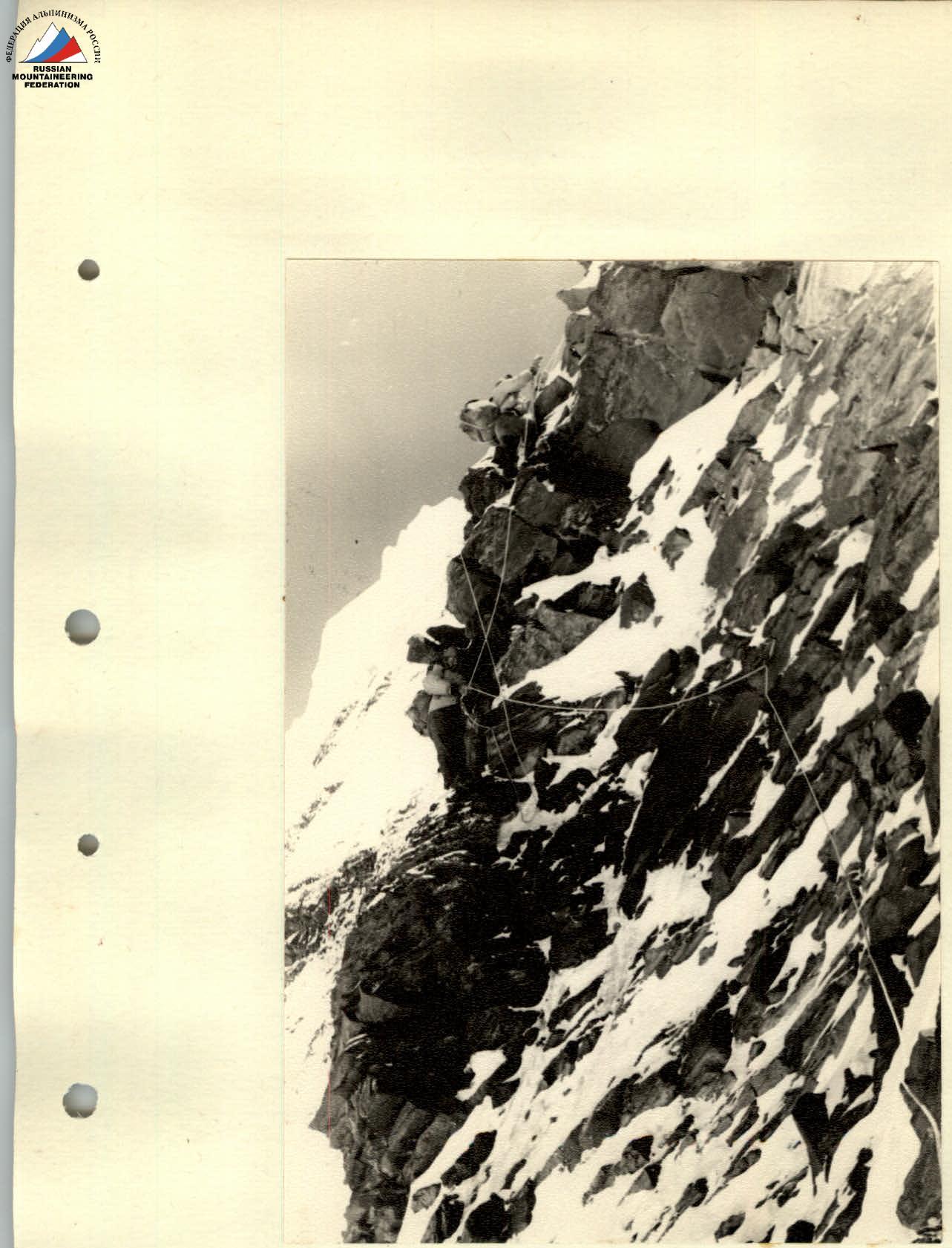
 6th section. Bypassing the overhanging rock.
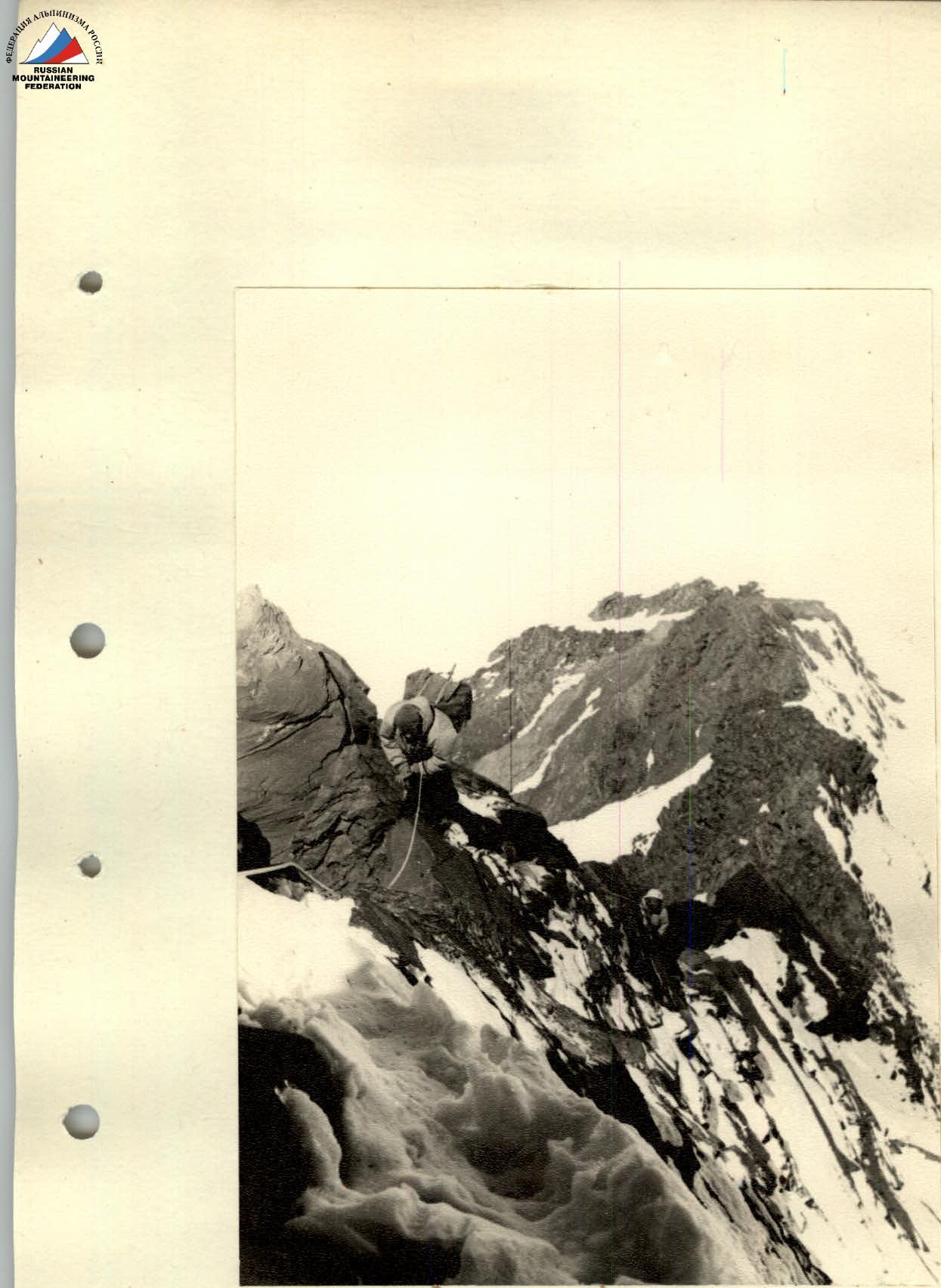
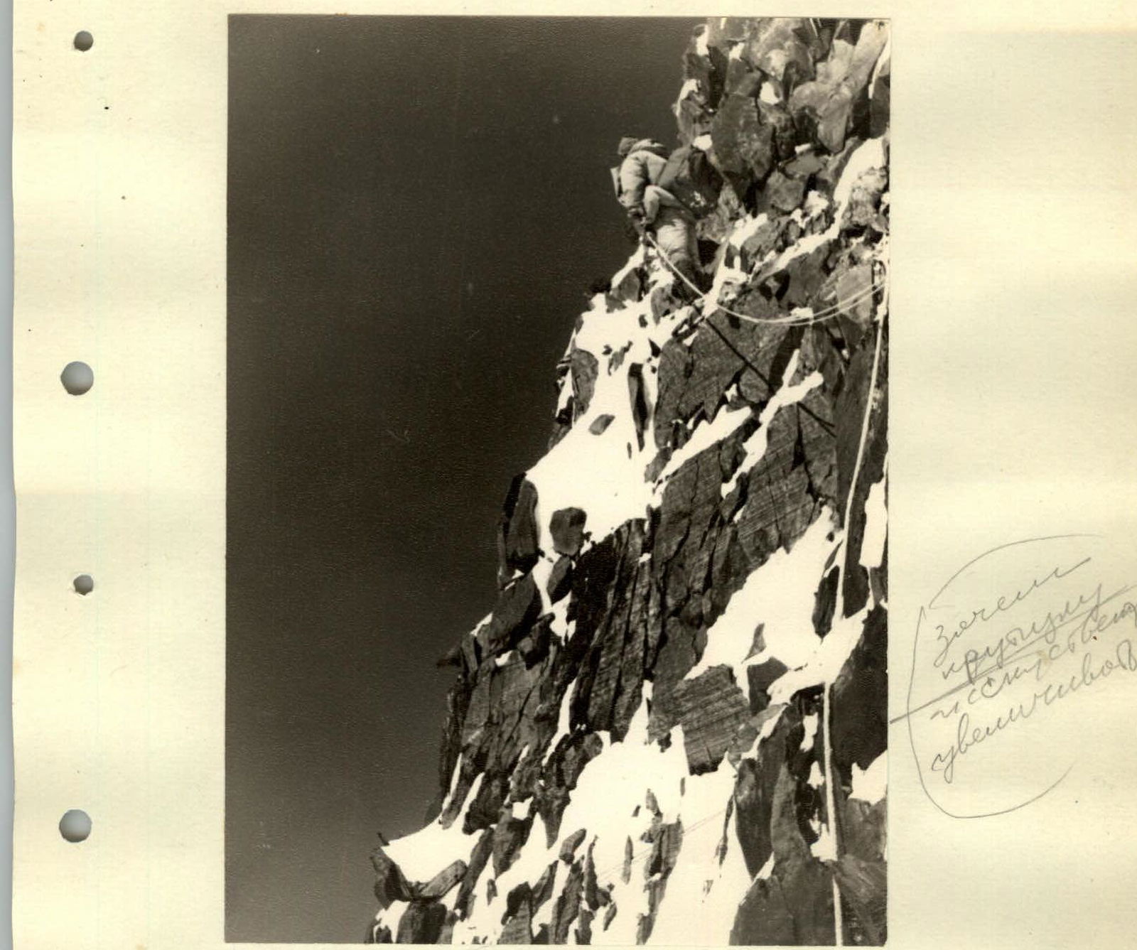
 7th section. Movement along the ridge before reaching the western summit of Peak Voroshilov.
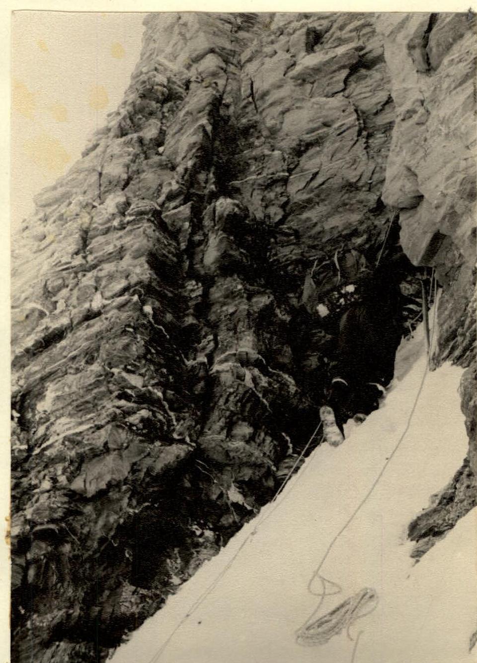 Peak Korzhenevskaya. Upper part of the triangle. Exit under the chimney.
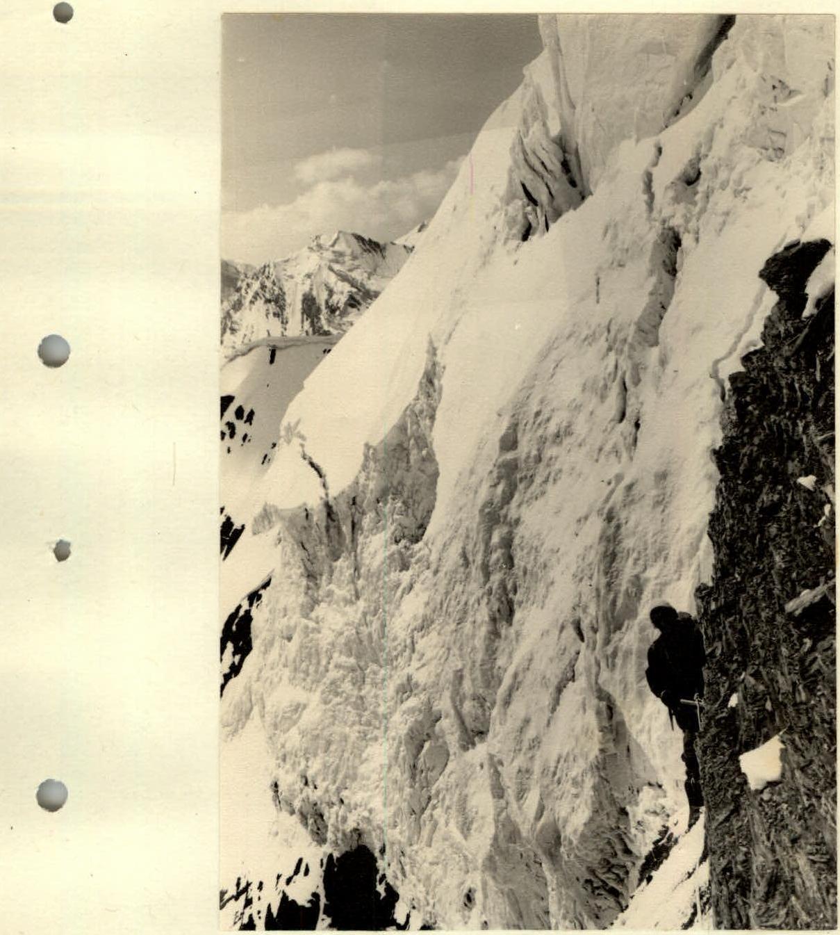 22nd section. Bypassing ice drops along the rocky wall of Peak Korzhenevskaya.


