
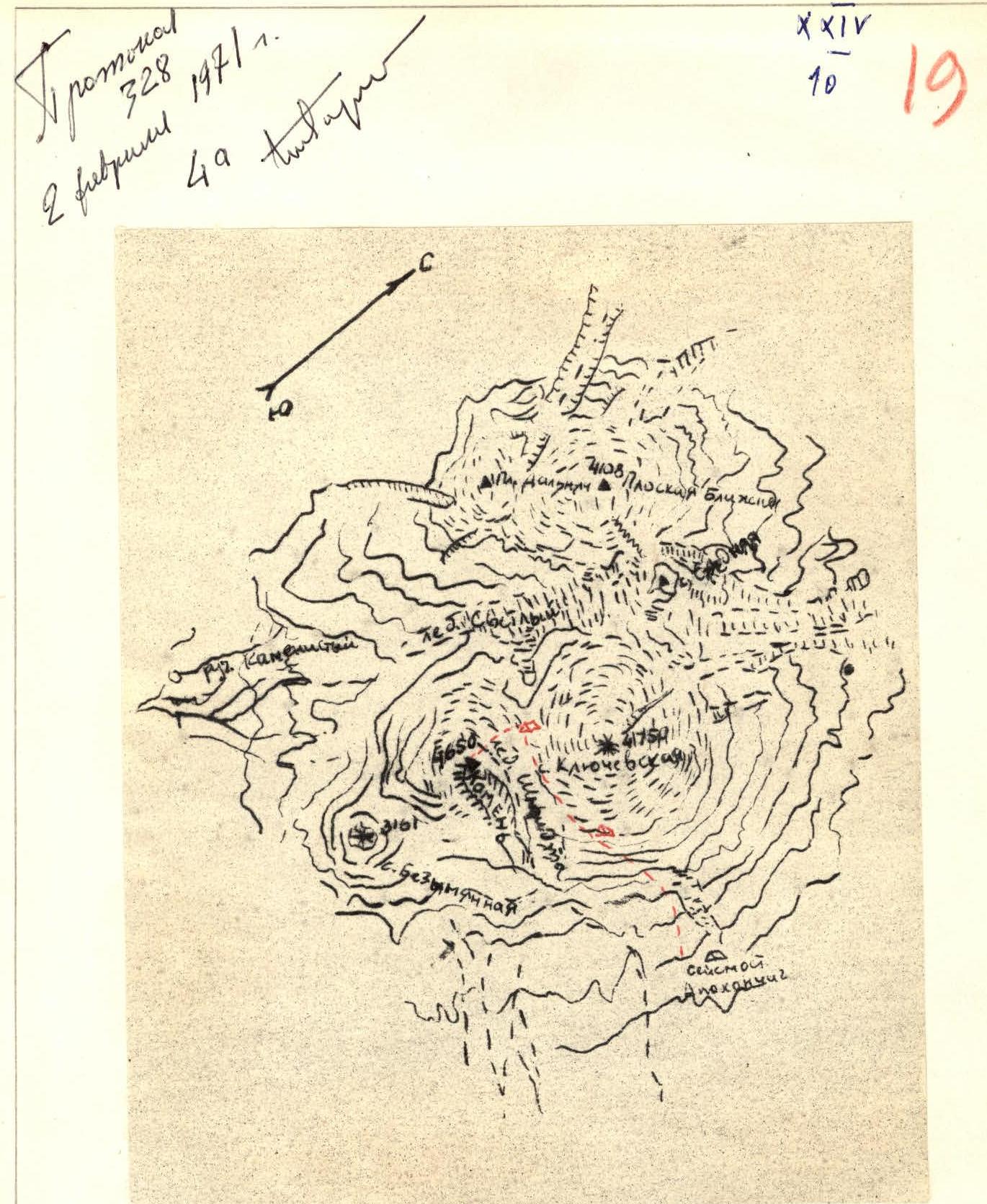
Map of the Area
Description of the ascent to the summit of Kamen via the NORTHERN EDGE, 4A cat. diff.
The Kamen peak is part of the Klyuchevskaya group of volcanoes. It is the second highest peak in Kamchatka. Its absolute height above sea level is 4650 m.
Kamen is a volcano of volcanic origin. It is the oldest volcano in the Klyuchevskaya group. Its slopes are composed of volcanic rocks: – basalt – diabase.
The volcano has a very large glaciation from the foot to the summit. The glaciers flowing from it to the north and northwest flow into the Svetly glacier.
From the western side, the icy slopes are largely cut by rocky ridges.
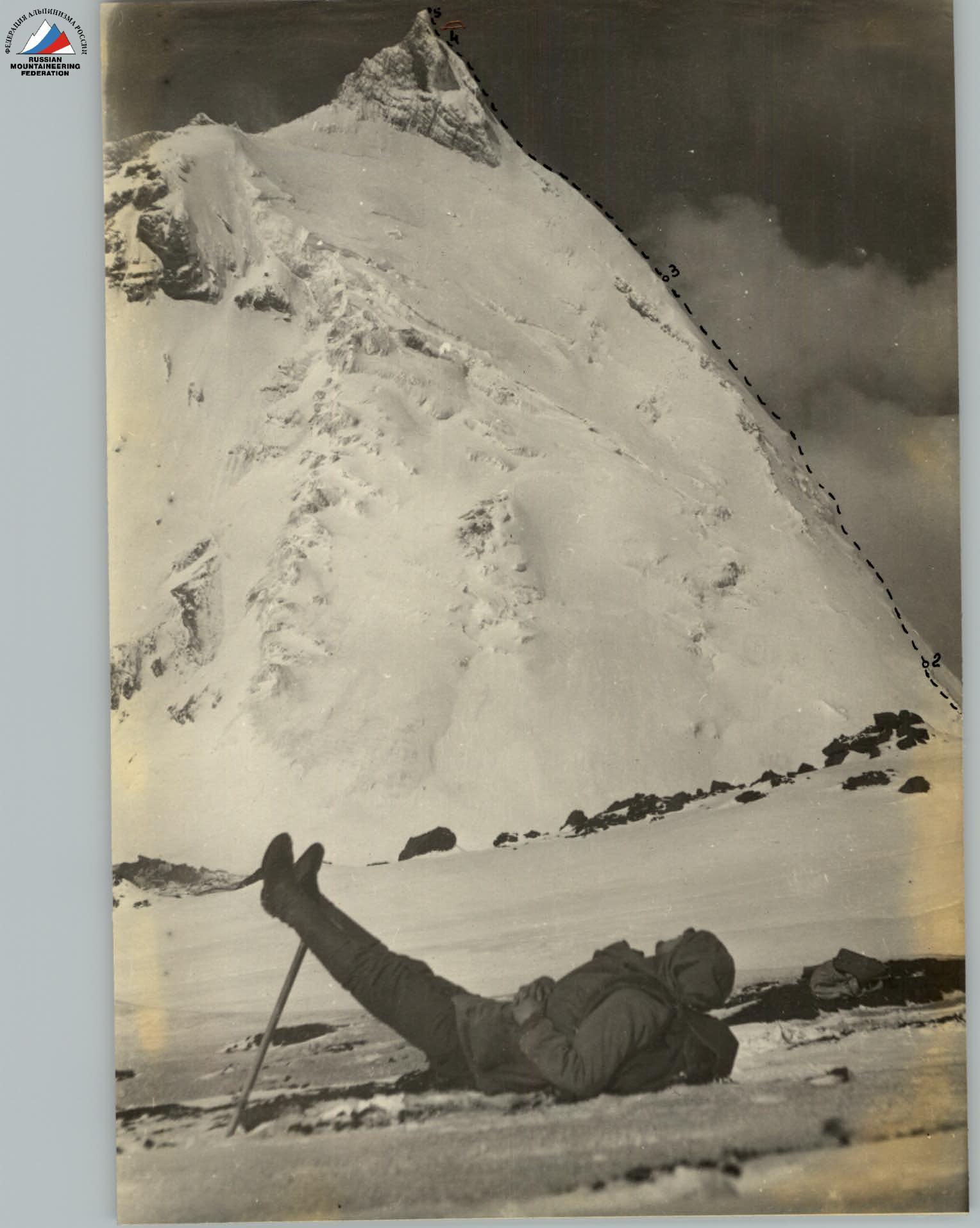
To the east of the summit, there is a sheer rock wall (2700 m) down to the Shmidt glacier, see photo 2.
The summit of the volcano is crowned by a powerful rocky tower.
The snow line in the warmest time of the year: – on the eastern side - does not rise above 2500 m; – on the northern side - 2100 m.
The weather in this area is unstable. Snow often falls in the second half of the day. The most favorable time for climbing is considered to be the period from July 20 to September 1.
The summit was first conquered in August 1958 by a group of climbers led by F. Chelnokov from the western side via the easiest route.
- Approach to the starting point of the ascent.
a) Traveling by car.
– By car on a dirt road from the village of Klyuchi to the seismic station "Apochonchich". – The length of the trip is 80-90 km. – The dirt road goes in a large arc from west to south around the foot of Klychevsky volcano. – Most of the road passes through alder and birch forests. – Driving a car is possible from July 1 to October 10. – In winter, communication is carried out by dog sleds. – Cars regularly travel to the seismic station from the branch of the Kamchatka Institute of Volcanology in Klyuchi 3-4 times a month.
The seismic station is located at an altitude of about 700 m above sea level at the end of the frozen lava river Apochonchich, which flowed out during the eruption of Klychevsky volcano in 1948. Around the station: – a vast slag plateau, – cut by dry rivers, – rare islands of alder bushes.
The station has been operating year-round since 1957. There is a radio station, regular communication with Klyuchi twice a day.
There is no water, firewood or gasoline at the seismic station. All this is delivered from Klyuchi by car and helicopter.
The car trip takes 5-6 hours.
b) Hiking to the starting point of the ascent. Day 1.
Moving up along the right bank of a dry river (filled with dirty water from the second half of the day).
Direction - to the upper reaches of the Shmidt glacier.
It is possible to move on horseback. The camp should be set up at the left-bank moraine of the Shmidt glacier.
Altitude 2100 m. Time spent on the transition - 5-6 hours. Day 2.
The direction of movement is the upper reaches of the Shmidt glacier. The Klychevskoy volcano is bypassed with a gradual gain in altitude.
When moving, several gentle couloirs are crossed, filled with snow and ice, sprinkled with slag.
In the second half of the day, stones fall along the couloirs, low clouds cover the entire path. Therefore, a very early exit is recommended from the overnight stay.
When moving: – It is not recommended to go to the Shmidt glacier. – It can only serve as a good landmark, fencing the route on the left, when moving in the fog.
Exit to the saddle between the Klychevskaya and Kamen volcanoes. Here in the direction: – to the east - the source of the Shmidt glacier, – to the west - the Svetly glacier.
Here, on the glacier, there are many convenient areas covered with slag. There is water. From this camp it is convenient to make an ascent: – to the Klychevskoy volcano via route 2A cat. diff., – to the Kamen volcano via route 4A cat. diff.
It is impossible to move on horseback to this camp. There are sites for receiving helicopters and cargo dropped from airplanes and helicopters.
Altitude 3300 m. Time spent on the transition 7-8 hours.
- Description of the route by sections.
The relative height of the ascent from the start of the ascent to the summit is 1350 m. The route is shown in photo 1 and photo 2.
R1. Height difference 300 m. Steepness 30°. On firm snow on the left of the rocky ridge with an exit to the rocks. Duration of movement 2 hours 00 minutes.
R2. Height difference 180 m. Steepness 40-45°. Along the rocky ridge through iced rocks of medium difficulty. Insurance through rocky outcrops. Duration of movement 1 hour 30 minutes.
R3. Height difference 530 m. Steepness 50-55°. Along the icy slope and through the icefall to the right of the rocky ridge. On the icefall, there are small ice walls 4-7 m high, steepness 70-80°. Section with piton insurance. It is not recommended to go to the rocks: very steep, smoothed iced rocks. Duration of movement 6 hours 00 minutes.
R4. Height difference 300 m. Steepness 45°, on the final section up to 55°. Along the snowy sharp ridge. The snow is deep, crumbly, in some places lies on an icy base. The snow ridge ends with a small depression in front of the rocky tower. The most convenient place to spend the night on the entire route. Duration of movement 2 hours 00 minutes.
R5. Height difference 40 m. Steepness 80°. Exit to the summit via a cleft filled with ice. The rocks are strong. Piton insurance. Duration of movement 2 hours 00 minutes.
-
Descent from the summit. Descent from the summit strictly along the ascent path. Duration of movement 5 hours 00 minutes.
-
Calculation of the time taken to complete the route by days and hours.
Day 1: Approaches from the seismic station Day 2 Day 3: – R1: 2 hours 00 minutes. – R2: 1 hour 30 minutes. – R3: 6 hours 00 minutes. Day 4: – R4: 2 hours 00 minutes. – R5: 2 hours 00 minutes. Descent from the summit: 5 hours 00 minutes. Total: 18 hours 30 minutes.
- Recommendations for climbers.
When approaching from the seismic station "Apochonchich" to the saddle 3300 m, the entire route should be carefully marked. It is recommended to set up a base camp in a snow cave. Exit to the ascent not later than 3:00 am.
Special equipment for a group of 4 people.
– Main rope: 2×40 m – Rock pitons: 6 pcs. – Ice pitons: 6 pcs. – Carabiners: 6 pcs. – Repschnur consumable: 12 m – Crampons: 4 pairs
The description was compiled by S. Grinkevich, December 7, 1970.
Comments
Sign in to leave a comment