
Passport
- Russia, Kamchatka Peninsula, Ganal'skiy Ridge, "Ganal'skie Ostryaki" area. Section No. 3 KMGV.
- Main Peak (2062 m). Route: "via the South Ridge".
- Proposed - 4A category of difficulty. First ascent.
- Nature of the route: rock.
- Height difference of the route: –592 m.
Route length: –710 m. Rock section length: –360 m. Length of sections: 5 category of difficulty — 8 m. Average steepness of the main part of the route — 58°
- Pitons left on the route: total — 1 piece;
Total used on the route: rock pitons — 18, friends and chocks — 50, including IT — 0
- Team's climbing hours: 11 hours.
- Leader: Ivan Benedyk Nikolayevich — 1st sports category
Members: Oleg Chirik Vladimirovich — Candidate for Master of Sports, Denis Ermolaev Alexandrovich — 2nd sports category
- Coach: Valery Karpenko Nikolayevich — Master of Sports
- Exit from Base Camp: 5:20, June 17, 2006.
Exit to the route: 6:40. Summit — 17:30. Return to Base Camp — 22:30, June 17, 2006.
General photo of the peak (panorama of the area)
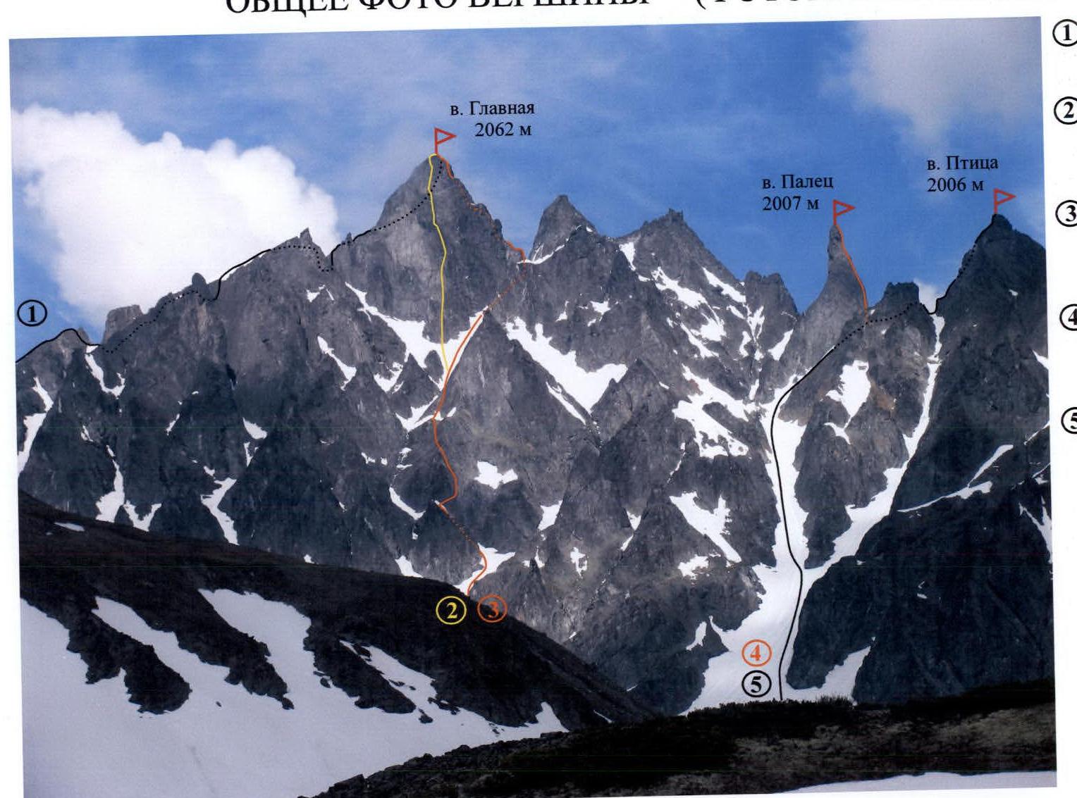
(1) "From the northwest", 3B category of difficulty. 1981. Leader: I. Korbuh. (2) "Through the center of the southwest wall", 5B category of difficulty. 1991. F. Farberov, S. Panyukhin. (3) "Via the South Ridge", 4A category of difficulty. 2006. I. Benedyk, O. Chirik, D. Ermolaev. (4) "Via the South Ridge", 5A category of difficulty. 1991. F. Farberov, S. Panyukhin. (5) "Via the North Ridge", 3B category of difficulty. 2005. I. Benedyk, O. Chirik, E. Lysenkov.
The photo was taken from the base camp. Distance — 2000 m. Shooting point No. 1. Height 900 m. July 8, 2005.
Camera: Canon Power Shot Pro 1 (Zoom)
Photo from the right (view from the southeast)
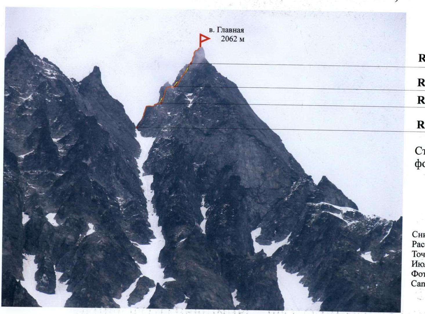
R13 photo No. 7. Control shot:
- R12 photo No. 5, No. 6
- R11 photo No. 4
- R10 photo No. 3. Arrows indicate the direction of photography
The photo was taken from the "Park of Rocks" cirque. Distance — 1500 m. Shooting point No. 2. Height 900 m. July 2005. Camera: Canon Power Shot Pro 1 (Zoom)
Map-scheme of the ascent area
Scale: 1×125000

Milkovo village 163 km Petropavlovsk-Kamchatsky 134 km.
- (1) — Palets Peak 2007 m.
- (2) — Ptitsa Peak 2006 m.
- (3) — Yuzhnaya Peak 2050 m.
Approach route:
- Base camp. 900 m. Shooting point No. 1
- Shooting point No. 2. 900 m.
Brief overview of the ascent area
In the southern part of the Kamchatka Peninsula, within the system of the Greater Eastern Ridge, lies a unique, compact area — the Ganal'skie Ostryaki Ridge.
Its length from northwest to southeast is 20 km, width is about 10 km. Maximum height — Main Peak 2062 m. The area is characterized by alpine mountain structure, with wall height differences reaching 450 m.
Despite the relatively low absolute height of the objects, winter here lasts nine months:
- First frosts occur from early September
- Snow falls from September 15-20
- In December-February, temperatures reach –45 °C
- Snow at the base camp level melts only by mid-June
Major ascents in the area were made during the summer. The most suitable period for expeditions is from mid-June. At this time, it is already warm and there are no mosquitoes and midges, which are very bothersome in July. The most stable and clear weather is in late August and early September.
To reach the area, one can:
- From Petropavlovsk-Kamchatsky, take any vehicle to the bridge over the Vaktan Malkinskiy River (144th km of the Milkovo highway, see the map-scheme of the area).
- After the bridge — turn right, along the forest road, you can drive a total of 5–6 km.
- Then — on foot or by high-clearance vehicle another 5 km to the entrance to the gorge on the left (the first tributary of the V. Malkinskiy River).
- The road ends here.
- Then, turn left, in the alder bushes, there is a footpath.
- Walk along the left side of the valley upwards until you reach the terrace.
- Then cross the bed of a small stream at the boundary of the forest and bushes.
- The ascent to the upper valley will take 50–60 minutes.
From this point, a panorama of all the main peaks opens up: Yurchik, Main, Palets, Ptitsa, Yuzhnaya. From here to the base camp — 3 km.
Further:
- The trail goes along the left slope of the tributary flowing from Yurchik Peak.
- After 400 m — cross the tributary and head towards the cirque, to the cedar trees on the moraine cushions.
- Here, near the right side of the gorge, under a clearly defined pass — is a good spot for the base camp.
Travel time from the city to the Vaktan Malkinskiy River — 2.5 hours. Walking part of the journey — 10 km, which takes 3.5–4 hours.
In the Ganal'skie Ostryaki cirque, helicopter landing is possible.
Approach to the route:
- From the base camp, up the gorge along the stony moraine — 1.5 km to a large snowfield completely covering the cirque floor.
- Then move along the snowfield straight almost to the end of the cirque, then turn right — up the steep snow towards the rock standing in the center of the couloir under the Main Peak (a good landmark — a waterfall flowing from the snow "necktie" lying under the summit tower).
- Here, at the first rock (height 1470 m), is the beginning of the technical part of the route.
Time to approach the route — about 1.5 hours.
Technical photo of the route
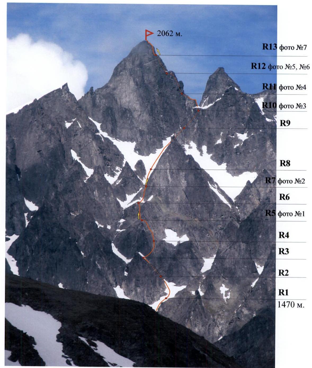
R — belay station (No. in the list). Arrows indicate the direction of photography
The photo was taken from the base camp. Distance — 2000 m. Shooting point No. 1. Height 900 m. Camera: Canon Power Shot Pro 1 (Zoom). Date: July 8, 2005.
Route diagram in UIAA symbols
Part No. 2. View from the southeast. Scale 1:2000
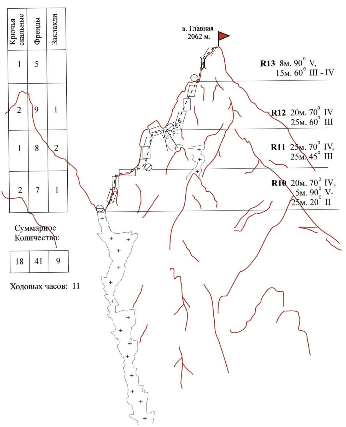
Main Peak 2062 m.
| Rock Pitons | Friends | Chocks |
|---|---|---|
| 1 | 5 | |
| 2 | 9 | 1 |
| 1 | 8 | 2 |
| 2 | 7 | 1 |
Total quantity: 18, 41, 9 Team's climbing hours: 11 hours.
Description of the sections shown on the diagram:
- R13: 8 m, 90° 5; 15 m, 60° 3–4
- R12: 20 m, 70° 4; 25 m, 60° 3
- R11: 25 m, 70° 4; 25 m, 45° 3
- R10: 20 m, 70° 4; 5 m, 90° 5; 25 m, 20° 2
Route diagram in UIAA symbols
Part No. 1. View from the southwest
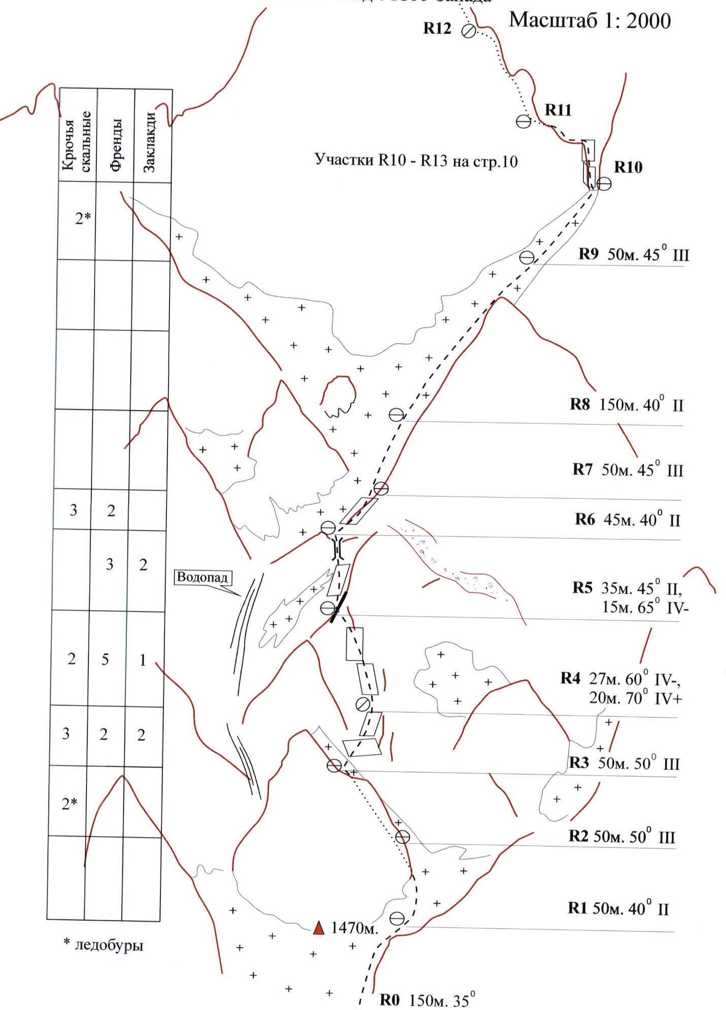
Sections R10–R13 on page 10. Waterfall. 1470 m.
| Rock Pitons | Friends | Chocks |
|---|---|---|
| 2* | ||
| 3 | 2 | |
| 3 | 2 | |
| 2 | 5 | 1 |
| 3 | 2 | 2 |
| 2* |
*Ice screws
Description of the sections shown on the diagram:
- R9: 50 m, 45° 3
- R8: 150 m, 40° 2
- R7: 50 m, 45° 3
- R6: 45 m, 40° 2
- R5: 35 m, 45° 2; 15 m, 65° 4
- R4: 27 m, 60° 4; 20 m, 70° 4
- R3: 50 m, 50° 3
- R2: 50 m, 50° 3
- R1: 50 m, 40° 2
- R0: 150 m, 35°
Route description by sections
Section R0
Up the snowy couloir straight up 150 m towards Main Peak, approach to the rock. Landmark — waterfall above on the left. At the rock is the start of the route (height 1500 m).
Section R1
Along the rock, bypassing to the right upwards 50 m. Behind the rock — a narrow steep snow-ice couloir leading to the top of the rock.
Section R2
Up the snow-ice couloir, steepness about 50°, in the upper part — ice, belay via ice screws. Station — rocky outcrop, on a small rocky ledge just below the ridge.
Section R3
Then — to the right and up, traverse along oblique slabs 50 m. Belay: chocks and friends, medium sizes*. Station — three pitons.
Section R4
Up the rocks, climbing category 4, exit to the ridge. Key point — difficult climbing in the second part of the rope before exiting to the ridge, steepness about 70°. On the ridge — station.
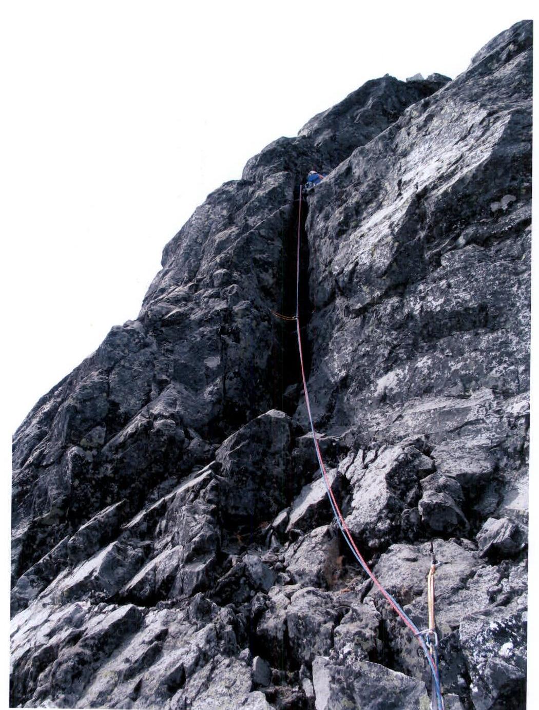
Section R5 (photo No. 1)
Then along the ridge to the left along inclined slabs, approach to the chimney. To the left is a waterfall. Chimney, steepness about 60°, leads to a ledge — station.
Section R6
To the left — the throat of the waterfall, to the right — a standalone rock. Traverse — 45 m up along the inclined slabs at the base of the rock. Station — piton, on an oblique ledge.
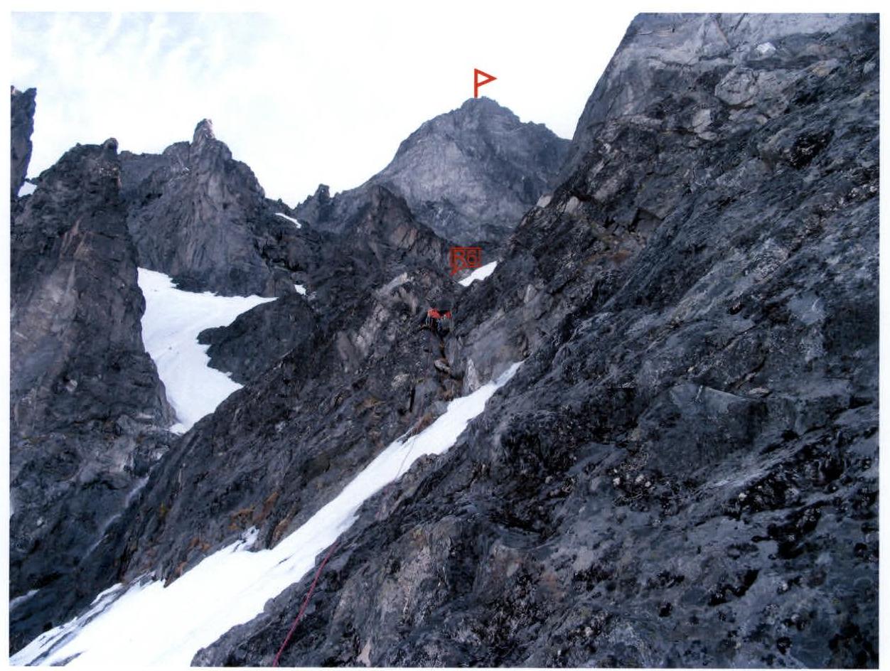
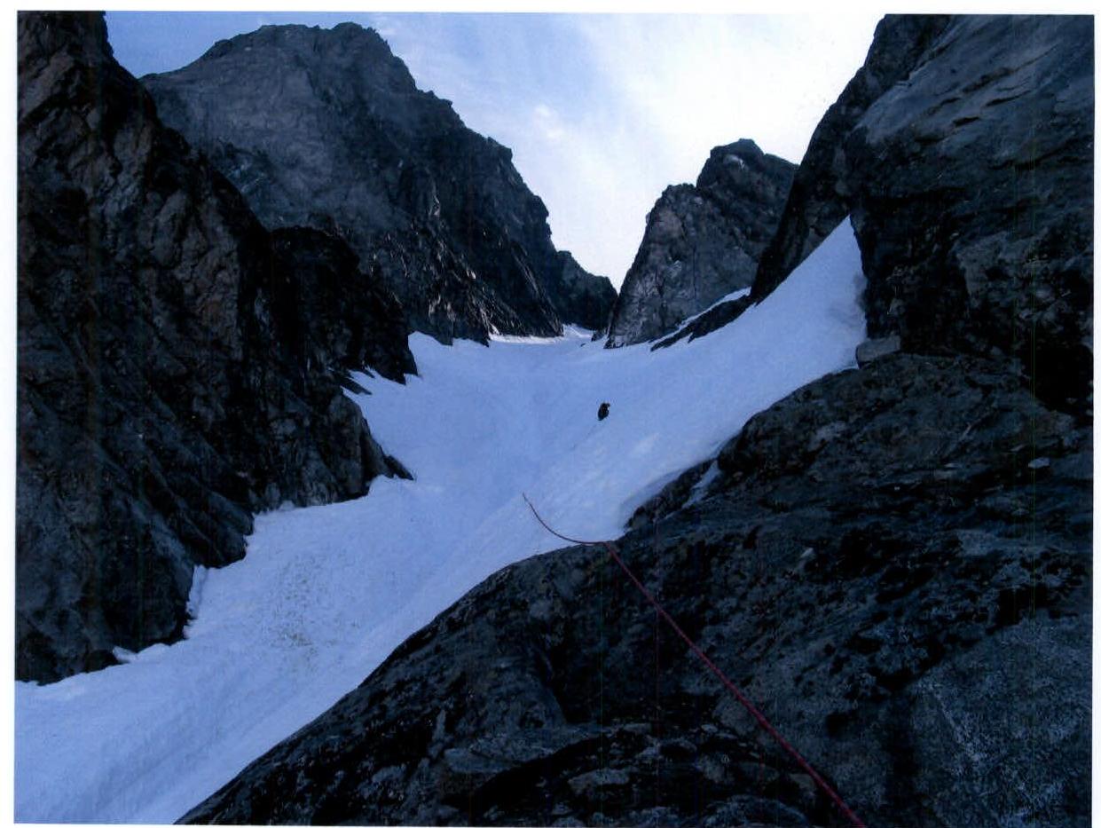
Section R7 (photo No. 2)
From the station, exit to the "snow-ice necktie". Up the snowfield to the left towards the summit tower. Caution — snowfield is steep up to 50°, to the left below — throat of the waterfall.
Section R8
150 m up the "necktie" and to the left, along the summit tower, steepness up to 40°. Closer to the end of the section, steepness increases.
Section R9
Ice section — 50 m. Belay — ice screws, steepness 45° or more. Exit to the ridge — station.
Section R10 (photo No. 3)
Start of the ascent to the summit tower.
- Up the inner corner — 20 m. 4. Caution, the corner ends in a protrusion of loosely stacked large stones.
- Then up 5 m of difficult climbing on a vertical wall and exit to the ridge.
- Then along the ridge 25 m — approach to the ascent.
Station (piton and two friends) on a small ledge.
On sections R11–R12, the route follows along the South Ridge to the right.
Section R11 (photo No. 4)
- From the station up 20 m along the steep ascent 4. Belay — friends, medium sizes.
- Then traverse along the ridge towards a heavily destroyed couloir.
- In the upper part — cross the couloir.
Station — an inconvenient spot on destroyed rocks (channel piton and two friends).
Section R12 (photo No. 5, No. 6)
- Then up along steep, about 70°, rocks.
- Start of the section — heavily destroyed rocks, then everything is quite solid, large macro-relief, but climbing is difficult, few cracks.
- "Live" stones are encountered, the belay is cautious.
- In the second part, the relief changes a bit, there are convenient cracks for friends of medium sizes.
The South Ridge ends on a convenient ledge under the summit bastion (photo No. 6), here is a convenient spot for a station (channel piton and two friends No. 2, No. 4). On the ledge in a small niche, just below the rocky channel piton, a control note is left in a plastic can.
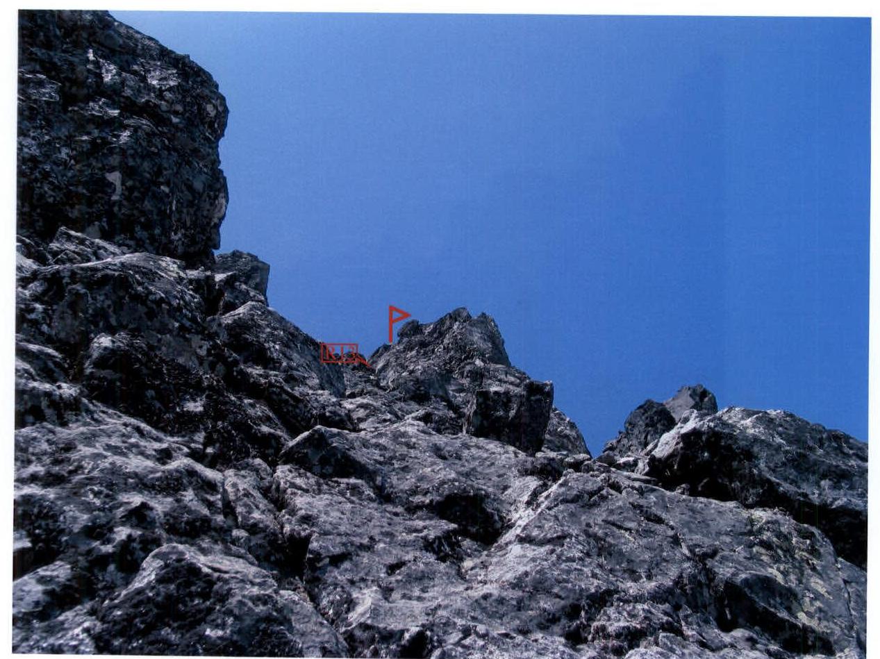
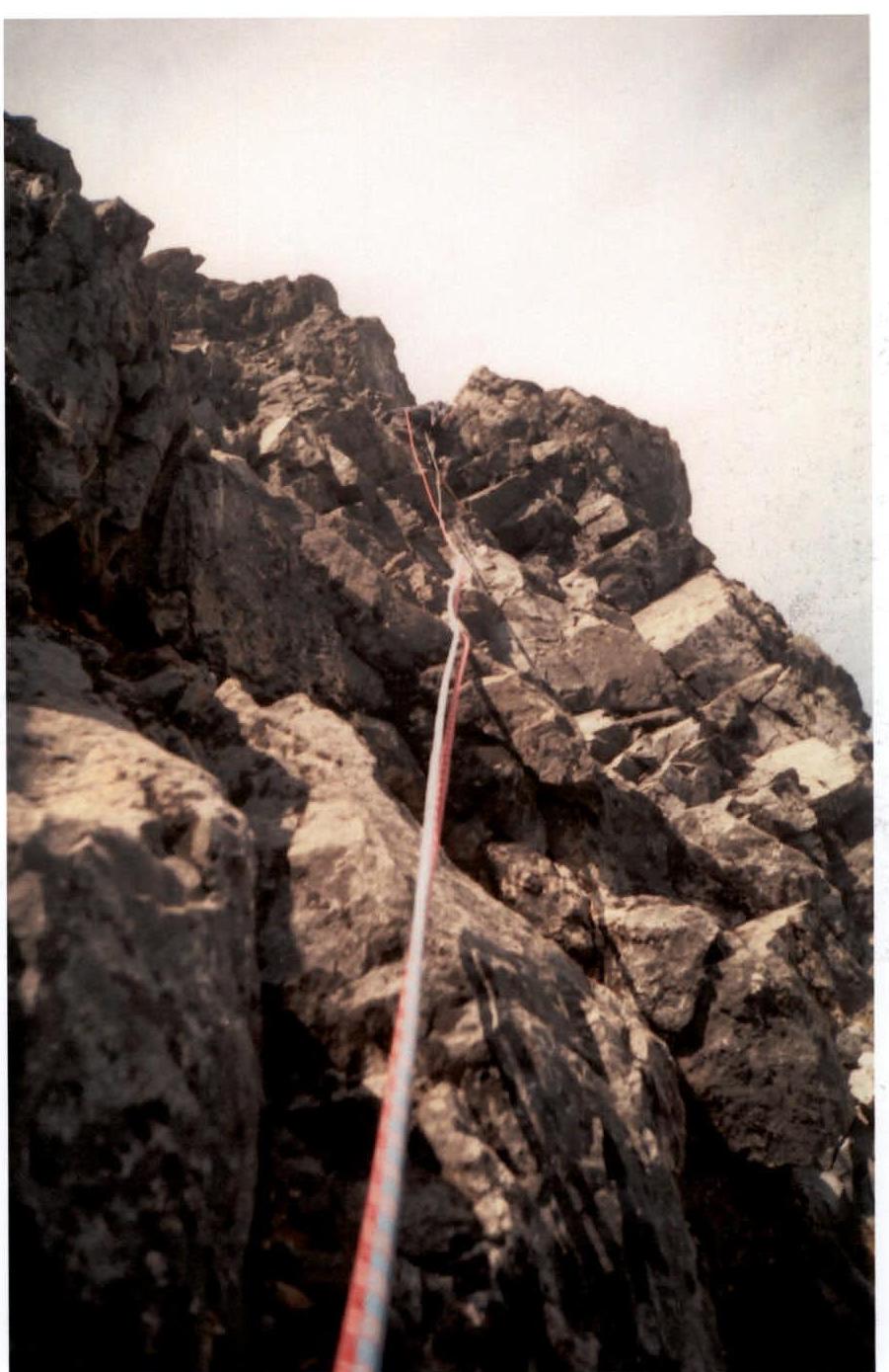
Section R13 (photo No. 7)
- Then from the station up to a vertical chimney.
- Chimney 6 m, width 40–50 cm, no cracks for belay.
- Surface is smoothed, edges are rounded, difficult climbing 5.
- From the chimney — exit to an inclined, smooth slab 60°.
- Belay — friends No. 0, No. 1. Along the slab, exit to the summit.
The summit is a flat area 1.5 × 5 m. From the northeast — protected by large stones forming a natural wall, about two meters high. From the northwest, the area is bounded by a rock. The height of the rock — 2.5 m, it is actually the highest point of Main Peak.
Descent from the summit via the 3B category of difficulty route "From the northwest".
- The team used friends of the following size range:
Flexible friends:
- No. 00 — for cracks width 10–12 mm
- No. 0 — 12–15 mm
- No. 1 — 14–18 mm
- No. 2 — 18–23 mm
- No. 3 — 20–25 mm
- No. 4 — 24–30 mm
Rigid friends:
- No. 1 — 28–33 mm
- No. 2 — 30–43 mm
- No. 3 — 38–50 mm
- No. 4 — 47–57 mm
- No. 5 — 54–67 mm
- No. 6 — 63–83 mm.
Photo No. 1
Section R5. Passage of the chimney
The photo was taken from the station of section R5. Camera: Canon Power Shot Pro 1 (Zoom). June 17, 2006.
Photo No. 2
Section R7
The photo was taken from the station of section R7. Camera: Canon Power Shot Pro 1 (Zoom). June 17, 2006.
Photo No. 3

Section R10
The photo was taken from the station of section R10. Camera: Samsung (focal length 35 mm). June 17, 2006.
Photo No. 4
View from the station of section R11
The photo was taken from the station of section R11. Camera: Canon Power Shot Pro 1 (Zoom). June 17, 2006.
Photo No. 5
Start of section R12
The photo was taken from the station of section R12. Camera: Samsung (focal length 35 mm). June 17, 2006.
Photo No. 6
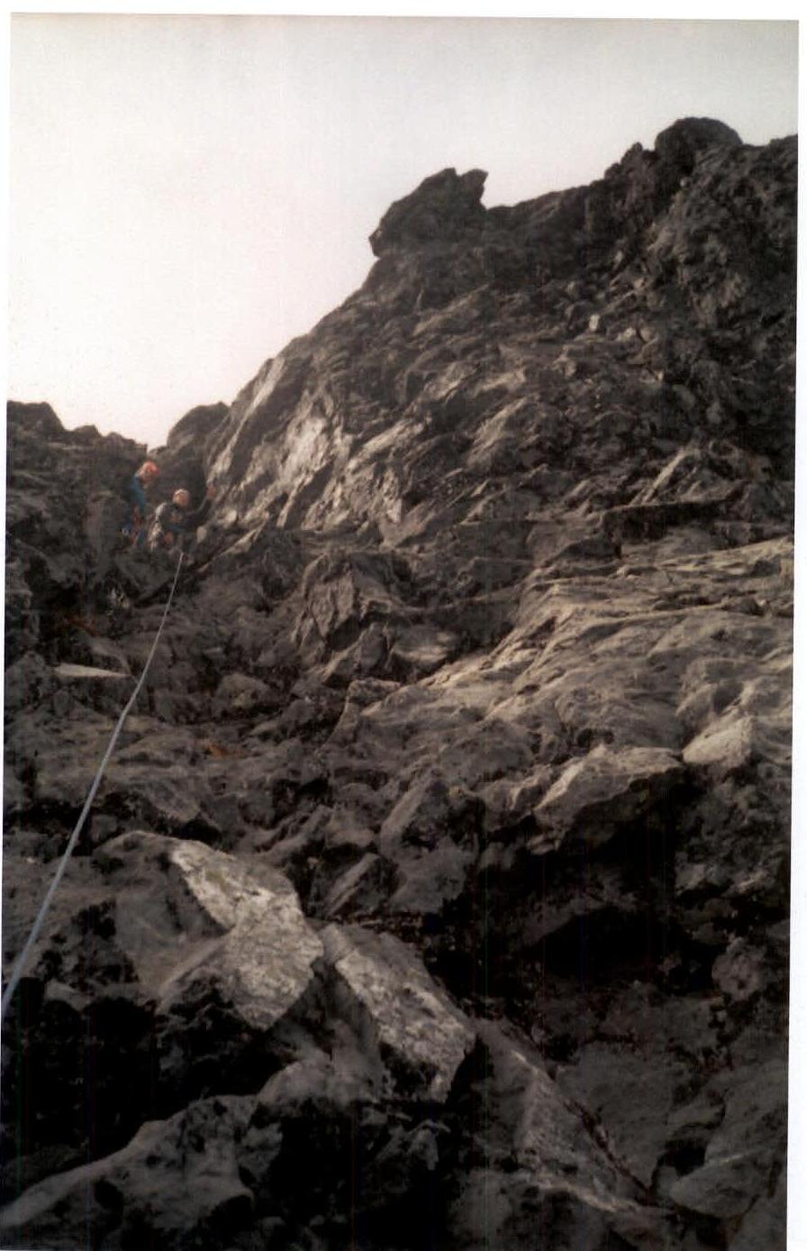
View of station R13 from the second part of section R12
Camera: Samsung (focal length 35 mm). June 17, 2006.
Photo No. 7
Section R13. Passage of the vertical chimney.
The photo was taken from the station of section R13. Camera: Canon Power Shot Pro 1 (Zoom). June 17, 2006.