I request that changes be made to the All-Union classification table for mountain routes:
- Kozelskaya sopka, traverse from northwest to southeast with ascent to the "tooth" of Kozelskaya via the northwest wall — Category 3A difficulty. Effective January 1, 1975, this route is to be classified as Category 2B.
- Koryaksky volcano, ascent via the northeast ridge — Category 3A difficulty. Effective January 1, 1975, in the winter period, the difficulty of this route is to be considered half a category higher, i.e., Category 3B, for the period from November 1 to May 31.
Rationale: Resolution of the Presidium of the Kamchatka Regional Federation of Alpinism dated December 24, 1975, Protocol No. 2, Item 1.
Appendices:
- Memorandum from the Route Classification Commission.
- Description of the route to Kozelskaya sopka, traverse from northwest to southeast, Category 3A.
- a) Description of the ascent to Koryaksky volcano via the northeast ridge, Category 3A (summer conditions). b) Description of the ascent to Koryaksky volcano via the northeast ridge (winter conditions), Category 3B for the period from November 1 to May 31. c) Photograph of Koryaksky volcano with the route via the northeast ridge marked.
Chairman of the Kamchatka Alpinism Federation, V.L. Sergeev.
To the Presidium of the Kamchatka Regional Alpinism Federation
The Route Classification Commission of the Kamchatka Regional Alpinism Federation has reviewed the description of the ascent to Koryaksky volcano via the northeast ridge, undertaken by a group of climbers led by instructor S.I. Grinkevich in April 1973 during the winter period, which in Kamchatka lasts from November 1 to May 31 (stable snow cover starting from 200–300 m above sea level).
The Commission concluded that, compared to the summer period, this route becomes significantly more complex in winter. The main features of the route in winter conditions are:
- All rocks are heavily iced. On the upper sections of the route, the snow is covered with extremely hard wind crust, and in some places, bare ice is exposed. Compared to summer conditions, the use of crampons and alternating belays is required over a significantly larger part of the route.
- Deep snow on the lower sections of the route necessitates the use of skis, which must be carried for the entire duration of the route, as the descent path does not coincide with the ascent path.
- Prevailing strong northerly and northwesterly winds and low temperatures during winter hinder movement and make it impossible to use the summer recommended bivouac site.
- A lower-lying first bivouac (in a cave) and a slower pace of movement make a second bivouac on the route necessary, near the summit or at the beginning of the descent (at the rock gates).
In view of the above, the route to Koryaksky volcano via the northeast ridge in winter conditions does not correspond to its summer classification of Category 3A.
The Classification Commission requests the Presidium of the Federation:
- To review the conditions for the ascent to Koryaksky volcano via the northeast ridge.
- To request the USSR Alpinism Federation to establish Category 3B difficulty for this route during the winter period from November 1 to May 31.
Instructors conducted a series of ascents to Kozelsky volcano in 1973–1974 to verify the condition of the routes and their classification.
Upon completing the route: Kozelskaya sopka, traverse from northwest to southeast with ascent to the "tooth" of Kozelskaya via the northwest wall, Category 3A, instructors CMS S.D. Klyukvin, I.E. Krinitsky, and S.I. Grinkevich concluded that the category of difficulty does not correspond to current requirements for routes.
The Commission proposes that this route be classified as Category 2B and requests the USSR Alpinism Federation to make the necessary changes to the All-Union classification table effective January 1, 1976.
Appendices:
- Description of the ascent to Koryaksky volcano via the northeast ridge, Category 3A.
- Description of the ascent to Koryaksky volcano via the northeast ridge, Category 3B in winter conditions, photograph 1.
- Description of the ascent to Kozelskaya sopka, traverse from northwest to southeast, Category 3A.
Chairman of the Route Classification Commission of the Kamchatka Alpinism Federation, Master of Sports O.G. Slesin.
Distinctive features of the ascent to Koryaksky volcano via the northeast ridge in winter
- General description of the summit and its location (see description of this route, Category 3A in summer conditions).
- Approach to the starting point of the ascent. Take a bus to the village of Zarechny, then ski 28 km. Cross the Mutnaya river by wading. The river's current is calm, with a water level of 60–70 cm. Ski through forest clearings and then along the Sukhaya river to the vulcanological station. Total ascent 900 m. Snow depth 25–40 cm. Time to the vulcanological station is 6–8 hours.
- Description of the route by sections Sections R1–R4 are traversed on skis through deep snow 20–30 cm deep; on steep inclines, snow depth is 40–60 cm.
Sections R5–R6
Traverse a couloir on skis. Snow is deep. Skiing is possible up to 40 cm deep. Further on, skis must be carried as the descent path significantly diverges from the ascent path. The exit to the ridge is steep, through very deep snow. Before reaching the ridge, there are large snow drifts. A good spot for creating a cave. Finding another suitable location for a cave is very difficult.
Section R6
From Section R6 onwards, movement on crampons is recommended. The ridge is 20–25° steep but covered with an ice crust and hard firn. The ridge is heavily exposed to cold northerly and northwesterly winds. At the end of Section R6, a bivouac is recommended in summer conditions. In winter, it is not advisable to bivouac here due to strong frosty winds and lack of protected areas under the rocks.
Sections R7–R10
These differ from the summer ascent in that the rocks have ice accretion and iced firn. On this section, for belaying, use rock pitons and special firn pitons (box profile, 0.5–0.7 m long). Belaying via an ice axe is not possible.
-
Descent from the summit. Descend via the southeast ridge, Category 2A. From the summit to the rock gates, there is a height difference of about 500 m, with hard firn, ice accretion, and short ice fields. Belaying is alternating via firn pitons. A bivouac is possible either near the summit (in a depression) or at the rock gates.
-
Time calculation for the route by days and hours.
Day one
- Ski transfer to the vulcanological station — 8 hours.
- Sections R1–R4 — 7 hours 30 minutes.
- Section R5 — 2 hours. Total: 9 hours 30 minutes.
Day two
- Section R6 — 2 hours 30 minutes.
- Sections R7–R10 — 9 hours. Total: 11 hours 30 minutes.
Day three
- Descent from the summit — 6 hours.
- Return to Zarechny village on skis — 5 hours.
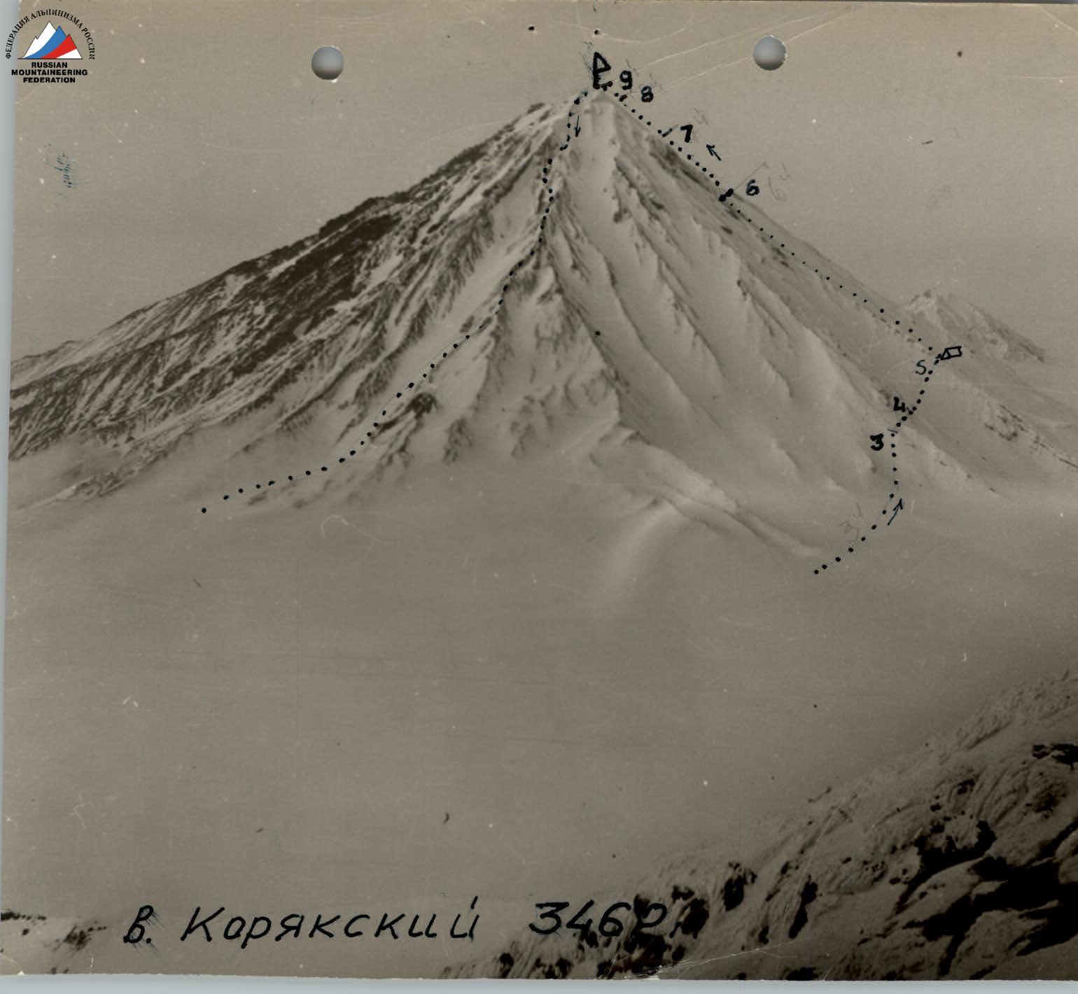 Koryaksky volcano. Height 3460 m.