Description of the Ascent of Koryaksky Volcano
Via the South Ridge, Category 3B difficulty
- General description of the summit and its location.
Koryakskaya Sopka is part of the Avachinsky group of volcanoes, located slightly east of the general direction of the Eastern Ridge.
Among the Avachinsky group of volcanoes, Koryakskaya Sopka is the highest. Its absolute height above sea level is 3456 m. Koryaksky volcano is considered active. It last erupted in 1957. Currently, its activity is characterized by intense fumarolic activity. Steam and gas escape from a fissure crater located on the western slope, 500 m below the summit. Koryakskaya Sopka is a summit of volcanic origin. Its slopes are composed of loose volcanic rocks: basalt, tuff, and diabase. The snowline rises to a height of 2 thousand meters by August and remains there until the beginning of September. On the northern slopes, snow persists at an altitude of 1300–1600 m. The NE, NW, and N slopes of the sopka are covered with glaciers, which are cut by rocky ridges in a radial direction. At an altitude of about 3000 m, the rocky ridges disappear under the ice armor. At this height, there is a continuous conical closed glacier. Between the ridges, the glacier flows down to a height of 1100–1400 m, giving rise to several tributaries of the Nalychovo River.
The western and eastern wings of the glacier end at the top of the South slope in a steep cirque.
On the southern side, the foothills represent a terrain heavily dissected by ravines. The ravines run in the directions:
- from north to southeast;
- from north to south and southwest.
The slopes of the ravines are densely overgrown with alder and dwarf cedar, which reach up to a height of 1300 m. The rugged terrain creates certain difficulties when approaching the initial ridge. In winter months, such terrain does not pose any difficulties for movement, as the deep snow cover buries the stlanik and significantly smooths out the deep ravines. However, in winter, another challenge arises: a thirty-kilometer journey from the passable road.
Koryaksky volcano is located thirty kilometers (in a straight line) from the city and is visible to the naked eye for most of the year. The ascent route via the South Ridge is also generally visible. This ridge consists of three rocky ribs that converge into a single massive node at a height of 2800 m. The ribs are separated from each other by deep couloirs. The couloirs are mostly always filled with snow. Rockfall hazard.
- Approach to the starting point of the ascent.
a) Traveling by vehicle.
- Drive by car to the 30 km mark on the asphalt road in the direction of Elizovo settlement.
- At the 30 km mark, turn right onto a dirt road through the settlement of Zarechny (5th stroika) to a residential area (see the map of the Avachinsky group of volcanoes).
- This is 9 km from the 30 km mark on the Elizovo highway.
- Further on, in winter, there is no road.
- In summer, further passage is possible during the period from July to October by trucks.
- The weak soil, undermined by the underground river flowing beneath, does not allow buses and taxis to pass.
- From this residential area, a dirt road leads to a ford across the Mutnaya River.
- 3 km after the ford, upon exiting the forest, the road enters the channel of the Sukhaya River.
- Further movement is only upstream along the Sukhaya River.
The riverbed represents a heavily eroded gully with low sediment deposits. The soil consists of volcanic rocks mixed with volcanic ash.
As you move upstream along the riverbed, the banks become steeper and higher. The hilly terrain beyond the riverbanks is covered with stone birch, alder, elm, rowan, and alder bushes.
After 10 km from the Mutnaya River, the first streams of the river disappearing underground appear.
The car journey ends at a mountain river that flows into the Sukhaya River from the left. This is 2 km from the elevation that limits the source of the Sukhaya River's channel. The mountain river, which flows from the left, passes through a deep ravine, the slopes of which are densely overgrown with stone birch and alder stlanik.
The absolute height here is 360 m.
The entire car journey from the city to this point takes 2.5–3 hours.
b) Hiking to the starting point of the ascent.
Movement along the mountain riverbed (see the map). The riverbed is stony, with some areas having a moraine character. The river is not wide but is turbulent. There are convenient places to cross from one bank to the other.
20 minutes of walking along the "wet river" leads to a left turn into a small hollow. The hollow is sometimes filled with snow in depressions or intersected by small thickets of alder.
20–30 minutes of walking along the hollow requires a sharp left turn through the alder stlanik and, descending into a small stream, going upstream along it.
40–50 minutes of walking along the stream leads to a cirque filled with perennial snowfields.
The cirque:
- is closed off to the northeast by a small hill, from which the first rib of the "Node" begins.
- turning left from the cirque and exiting into a wide moraine with a small river.
- this moraine separates the first rib from the second.
Crossing the moraine leads to an exit to the left, upwards, into a hollow overgrown with bushes.
Climbing through the labyrinth of passages between the bushes upwards to the boundary of dwarf cedar growth.
The hollow abuts the left slope of the second rib.
Here:
- there are extensive snowfields;
- water is available;
- there is firewood.
A good place to set up a base camp.
The transition from the cirque (at the foot of the first rib) to the base camp location takes 40–50 minutes.
The total hiking approach takes about 2 hours of walking time.
The height at which the base camp is set up is 1380 m above sea level.
- Description of the route by sections.
The relative height of the ascent from the start of the climb to the highest point of the route is 3100 m.
The count of the ascent by sections starts from the base camp.
1st section. Steepness 25–30°. Height difference 110 m. The slope is rocky with medium and small scree. Duration of movement 0 h 30 min. Descent from the base camp into the couloir between the second and third ribs. Loss of height 110 m.
2nd section. Height difference 410 m. Steepness at the beginning of the movement is 30°, and 20° for most of the route. The rib is composed of densely packed small and medium scree of diabase and volcanic tuff. Duration of movement 1 h 40 min.
3rd section. Height difference 120 m. Steepness 20°. Small scree from volcanic tuff. Duration of movement 0 h 30 min. The section begins at the point where a short rib to the left merges with the main ascent rib. A control cairn is installed at the junction.
4th section. Height difference 280 m. Steepness 20°. Simple, heavily destroyed rocks. The rock is diabase and tuff. There are many small gendarmes along the rib. Movement in teams. Simultaneous insurance. Duration of movement 1 h 40 min. Several steep drops in the direction of ascent, 3–4 m deep, are passed with alternate insurance. Gendarmes are approached head-on. Bypassing them is dangerous due to uncertain support reliability.
5th section. Height difference 260 m. Steepness 30°, in places up to 40°. Gendarmes 70–80°. Medium and small diabase scree. Gendarmes are composed of basalt. At the end of the section, there is a steep tuff slope. Duration of movement 1 h 50 min. The first gendarme (see photo 3) is 8–10 m high (passed head-on with an exit to the left). The second gendarme stretches significantly along the rib. It is bypassed to the right along a rocky, crumbly cornice (see photo 4) for 30–40 minutes. The gendarme ends with a vertical wall towards the ascent rib. At this point, the base of the gendarme connects to the rib with a thin, easily destroyed tuff ridge. Be very cautious!
6th section. Height difference 250 m. Steepness 30–40°, walls 60–80°. From the foot of the volcano, this place looks like an intertwining of bizarre towers and columns of frozen lava. The lava is predominantly composed of finely fragmented basalt cemented with slag and ash. In some places, pure basalt formations rise. The beginning of this section is the node of the three southern ribs converging into a ridge. Movement in teams with alternate insurance. Insurance is via pitons (rock and ice screws). Duration of movement 2 h 00 min. This section cannot be bypassed from below through the couloir because the narrow passages between the towers, rising 150–200 m upwards, represent completely vertical walls up to 60 m high, with some having negative angles. In these passages, small stones are constantly falling. The section begins with a basalt wall 5–6 m high. The rocks are crumbly (1 piton). After 2 ropes along a simple rocky slope with a steepness of 40 m, there is a second basalt wall 8–9 m high. The wall is passed to the right (see figure 1), 2 pitons. The rocks are crumbly. Upon exiting to the top, to the right, there is a third wall 27–30 m high (see figure 2). This wall is composed of compressed volcanic rocks of small formation gradations. 3 ice screws. At the top, the wall transitions into a dense, steep tuff slope (see photo 5.1).
7th section. Height difference 190 m. Steepness from 40° to 20° along the rocky scree. The slope is composed of densely packed tuff and slag. In the second half of the section, the rocky scree is medium-sized. Movement in teams with simultaneous insurance. Duration of movement 1 h 30 min. After the tuff slope, there is a transition into a small couloir (see figure 3) with a steepness of 15–20°. Ahead, a basalt remnant is visible. From the remnant, the path passes along medium rocky scree towards a basalt "finger" about 3–4 m high. At this point, the 2nd and 3rd ribs converge, further forming a ridge. At the end of the third rib, a control cairn is installed. At this point, the ascent ridge turns left. In this area, it is convenient to set up an overnight stay because there will be no convenient platforms for camping in the next transition. There is no water here. There are snowfields.
8th section. Height difference 180 m. Steepness 20–30°. The ridge is composed of dense slag. Along the ascent path, there is a long gendarme that is bypassed to the right along firn and formed ice. Movement in teams. Insurance is simultaneous along the slag, and alternate when bypassing the gendarme. Piton insurance is possible when bypassing the gendarme. Duration of movement 50 min.
9th section. Height difference 190 m. Steepness 30°. Rocky ridge. The rocks are simple, in some places moderately difficult. There are many gendarmes emerging from the rocky scree and tuff slope. At the end of the section, there is a long, medium rocky scree composed of diabase slabs. Movement in teams. Insurance is simultaneous, with alternate insurance when passing gendarmes (see photo 6). Duration of movement 1 h 50 min.
10th section. Height difference 180 m. Steepness 30°. Snow-firn ridge, with some areas having ice. There are small rocky outcrops. Movement in teams. Alternate insurance throughout the section. Duration of movement 1 h 30 min. The section ends at the pre-summit ascent.
11th section. Height difference 126 m. Steepness 40–50°. The exit to the summit is 60–70°. The slope is firn and ice. The summit point is a rock enveloped in firn (height 12–15 m). At the summit, there is a cairn on the rocks. Movement in teams, alternate insurance. Before the summit: 2 ropes, piton insurance. Duration of movement 1 h 00 min.
- Descent from the summit.
Descent from the summit is along the ascent route. When descending from the summit point, upper insurance can be organized through the summit rocky outcrop. When passing downwards through the 6th section, it is recommended to pass the rocky walls as follows:
- The THIRD wall — drive an ice screw into the upper part of the steep slope and hang a belay;
- The SECOND and FIRST walls — organize a rappel descent.
The duration of the descent to the base camp is 7 h 30 min.
5. Calculation of the time required to complete the route by days and hours.
Day one
Transition from Sukhaya River to the base camp: 2 h 00 min.
Day two
- R1: 0 h 30 min.
- R2: 1 h 40 min.
- R3: 0 h 30 min.
- R4: 1 h 40 min.
- R5: 1 h 50 min.
- R6: 2 h 00 min.
- R7: 1 h 30 min.
Total: 9 h 00 min.
Day three
- R8: 0 h 50 min.
- R9: 1 h 50 min.
- R10: 1 h 30 min.
- R11: 0 h 40 min.
- Descent to the base camp: 7 h 30 min.
- Descent to Sukhaya River: 1 h 30 min.
Total: 13 h 50 min.
Note: The itinerary is designed for climbers from Petropavlovsk-Kamchatsky, who have two days off per week.
-
Recommendations for climbers.
-
In winter (at the end of winter), it is sometimes possible to bypass the 6th section's walls from below through a narrow couloir (to the left of the ascent path).
In winter, the passage between the towers is filled with ice. An ice plug forms with a negative angle. Ice screws are more convenient to use in this case, hammering them into the rocky walls.
In windy weather, this bypass route is dangerous due to falling stones.
-
All climbers must wear helmets.
-
Special equipment for a group of 4 people: a) main rope 2 × 40 m; b) rock pitons 4 pcs.; c) ice screws 8 pcs.; d) carabiners 8 pcs.; e) cordelette 10 m; f) crampons 4 pairs.
-
Group composition: 4–6 people.
The description was compiled on October 29, 1969, by S. Grinkevich.
Map of the Avachinsky group of volcanoes. — approach routes — ascent routes.
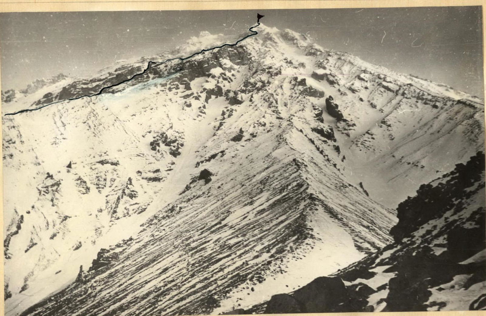
Photo 2.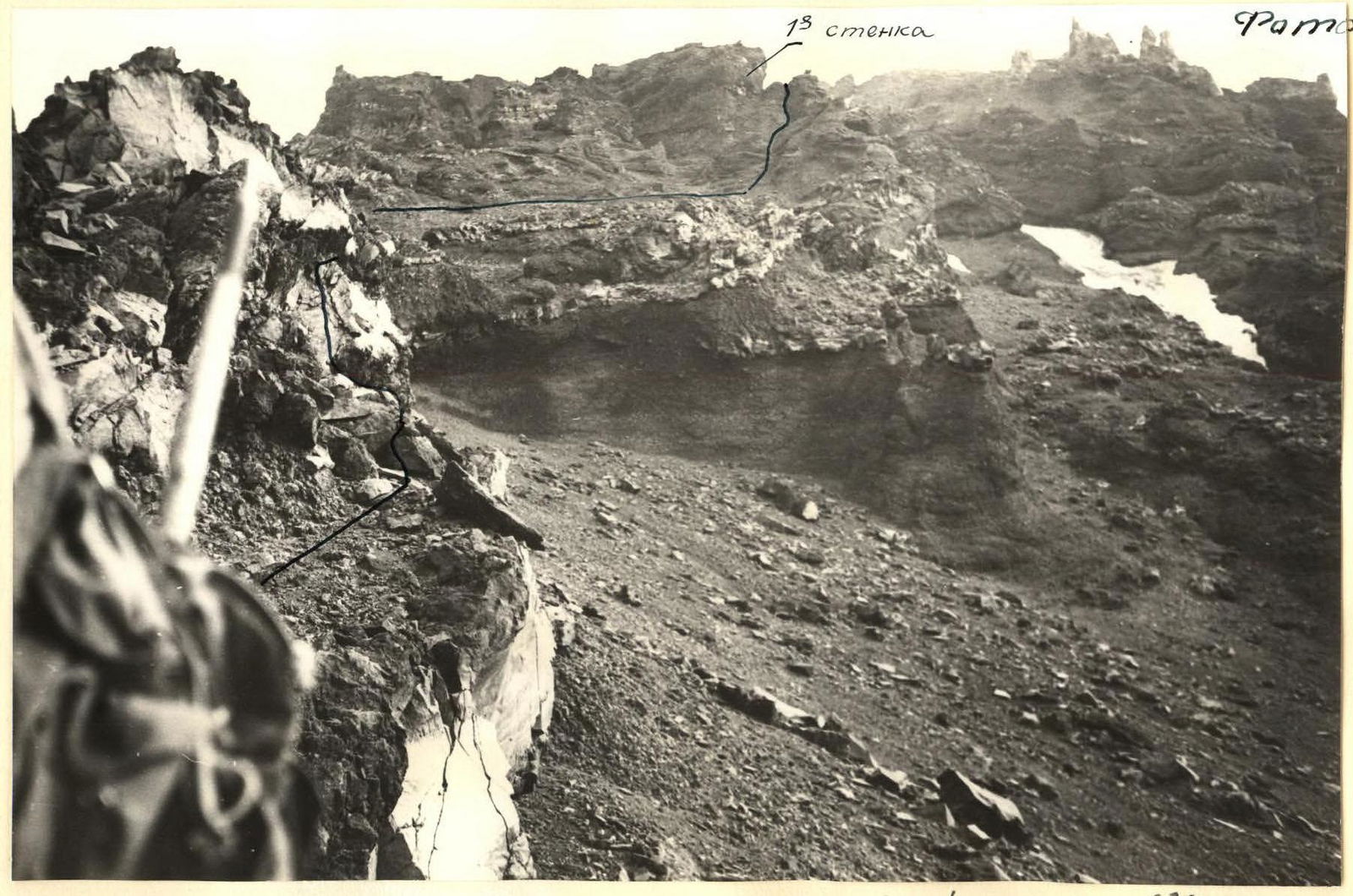
Photo 4. 2nd gendarme of the 5th section and 1st wall of the 6th section.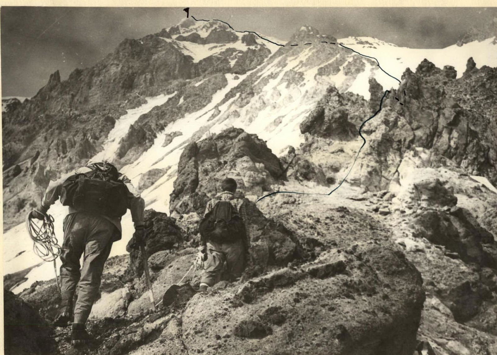
Sections 9, 10, 11.