26
Ascent Passport
- Ascent type: rock
- Ascent area, mountain range: Avachinskaya volcano group
- Peak, its height, ascent route, route type: Kozelsky peak, 2170 m, left buttress of the western wall, combined
- Proposed category of difficulty: 3B
- Route characteristics:
- elevation gain: 1070 m
- including the crux: 320 m
- route length: 1730 m
- including sections by difficulty categories:
- V: 40 m
- IV: 205 m
- III: 405 m
- II: 1080 m
- Average route steepness: 41°
- Average steepness of the crux: 70°
- Protection used:
| rock | ice | bolted | used chocks |
|---|---|---|---|
| 8 | 2 | – | 19 |
- Total climbing time: 12 h
including:
- approach to the route from the bivouac: 3 h
- time on the route: 6 h, including the crux: 4 h
- descent from the summit to the bivouac: 3 h
- Number of nights spent: none
- Surname, name, patronymic of the leader, participants, their qualification:
- Divaev I.V. – leader, 2nd sports category
- Volgina G.V. – participant, 2nd sports category
- Smelov S.V. – participant
- Malkov V.V. – participant
- Shefer V.V. – participant
- Bukov I.A. – participant
- Team coach: Loginov I.V., Candidate Master of Sports, instructor II category, certificate No. 2939
- Date of departure and return: May 2, 1985
- Organization: year-round training camps of the Kamchatka Regional Council of the "Urozhay" Sports Society
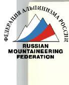
General View
(1) – category 1B by the SE slope (2) – category 1B by the 3rd ridge (3) – category 3B (proposed) by the left buttress of the 3rd wall (4) – category 2A by the 3rd buttress (5) – category 2B traverse of the N-NW summit, including "ZUB" (6) – category 1B by the SW edge (7) – category 3A from the East
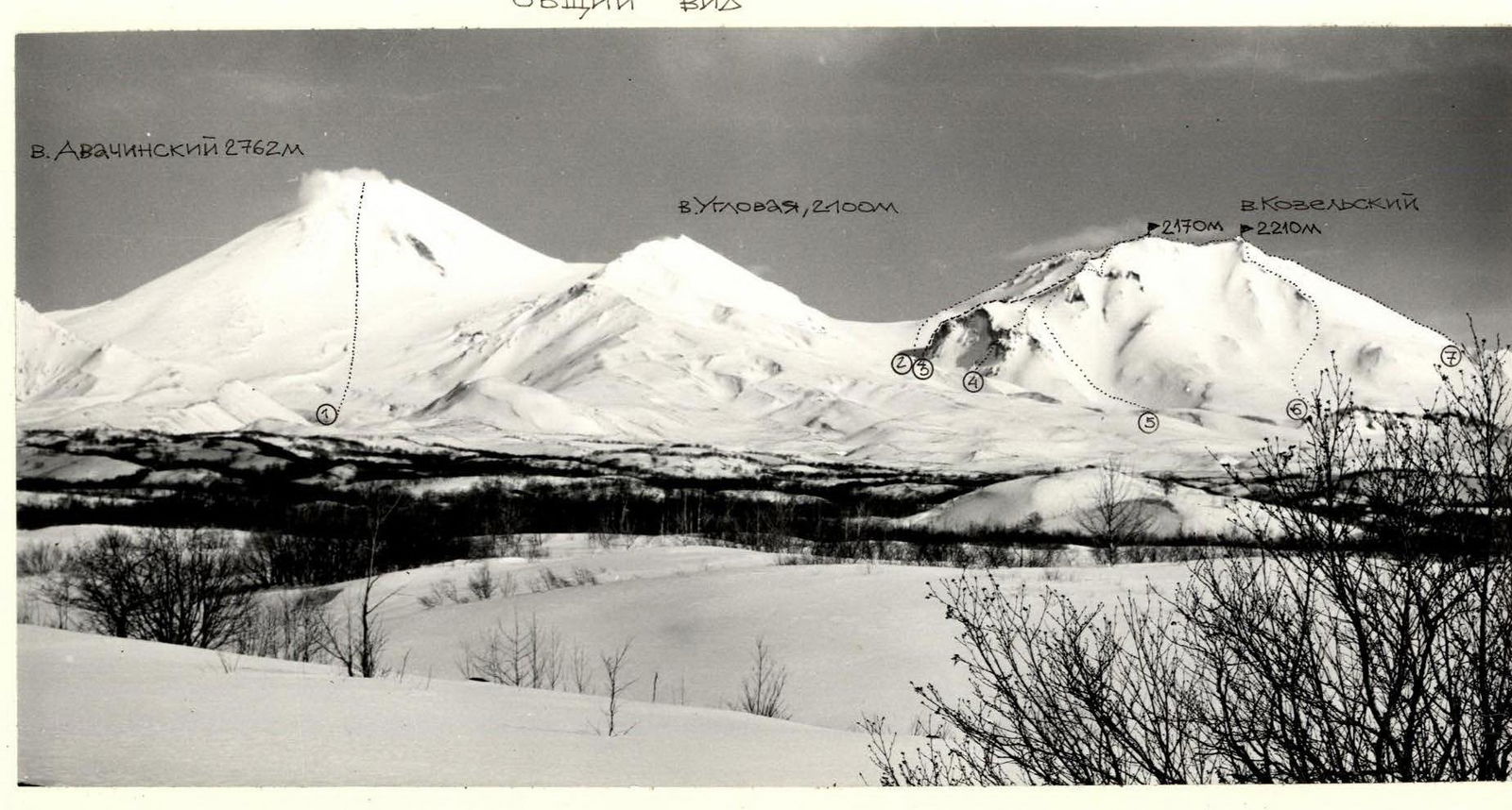
Area Map
Conventional signs: — approach to the route △ Bivouac in Kozelsky gorge
Brief description of the approach to the route
From Petropavlovsk-Kamchatsky to Rodygino settlement by bus — 1 h. Then 4 km on foot along the highway to the turn onto the old road. Along it, following the stream, to the entrance to Kozelsky gorge — 1 h. To possible bivouacs: near the "lower hut" — 1 h, near the "upper hut" — 2 h. Overnight stay here. Departure for the ascent not later than 5 h.
Approach to the route along the right side of the gorge upwards to the moraine opposite the False Pass is possible on skis — 1 h.
Then moving along the right part of Kozelsky glacier along the volcanic massif to the western wall with a pronounced buttress with a crosspiece — 1 h. It bounds the wall on the left. This is the route.
The approach from the bivouac near the "lower hut" takes about 3 h, from the "upper hut" — 2 h.
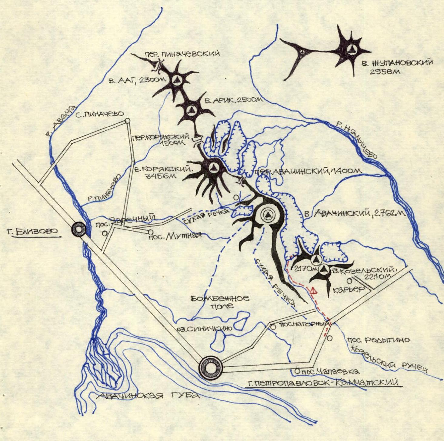
General view of the route
- R16
- R15 45°, 50 m, 2
- R14 25°, 80 m, 2
- R13 35°, 150 m, 2
- R12 60°, 30 m, 3
- R11 45°, 300 m, 3
- R10 30°, 800 m, 2
- R9 45°, 20 m, 3
- R8 50°, 20 m, 3
- R7 85°, 40 m, 5
- R6 30°, 15 m, 3 (crosspiece "knife")
- R5 60°, 25 m, 4 (flow ice)
- R4 70°, 60 m, 4
- R3 60°, 20 m, 3
- R2 80°, 40 m, 4
- R1 75°, 40 m, 4
- R0 70°, 40 m, 4 (Start of the route, 1100 m)
Climbing path Descent by category 2B route.
General view of the crux
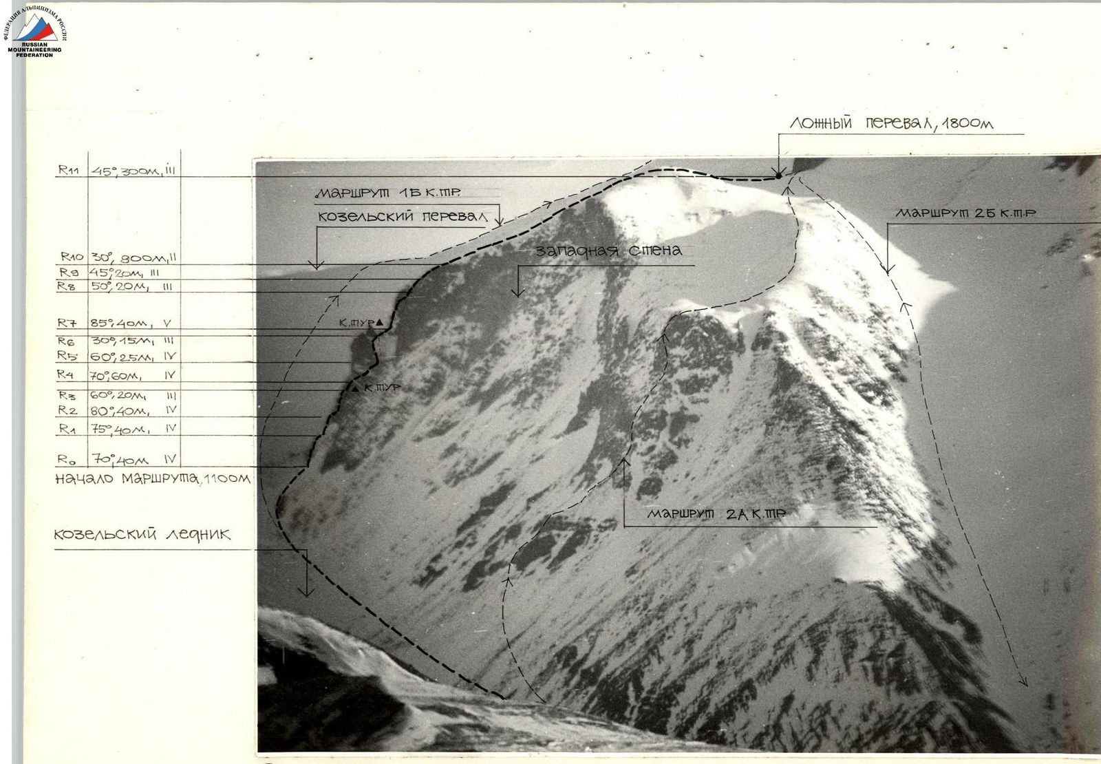
- Category 1B route
- Category 2A route
- Category 2B route
- False Pass, 1800 m
- Kozelsky Pass
- Western wall
- Kozelsky glacier
- R11 45°, 300 m, 3
- R10 30°, 300 m, 2
- R9 45°, 20 m, 3
- R8 50°, 20 m, 3
- R7 85°, 40 m, 5 (Crux PUR)
- R6 30°, 15 m, 3
- R5 60°, 25 m, 4
- R4 70°, 60 m, 4 (Crux MUR)
- R3 60°, 20 m, 3
- R2 80°, 40 m, 4
- R1 75°, 40 m, 4
- R0 70°, 40 m, 4 (Start of the route, 1100 m)
Route profile diagram
Absolute elevation gain, height marks in m.
| Section # | Length, m | Steepness, °C |
|---|---|---|
| R16 | ||
| R15 | 50 | 45 |
| R14 | 80 | 25 |
| R13 | 150 | 35 |
| R12 | 30 | 60 |
| R11 | 300 | 45 |
| R10 | 800 | 30 |
| R9 | 20 | 45 |
| R8 | 20 | 50 |
| R7 | 40 | 85 |
| R6 | 15 | 30 |
| R5 | 25 | 60 |
| R4 | 60 | 70 |
| R3 | 20 | 60 |
| R2 | 40 | 80 |
| R1 | 40 | 75 |
| R0 | 40 | 70 |
Route diagram in symbols
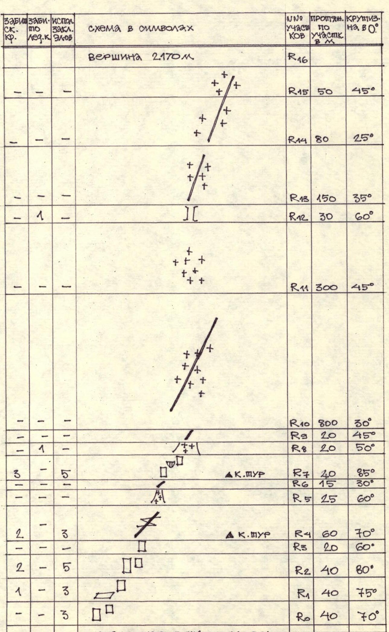
| Pitons used | Chocks used | Section # | Length, m | Steepness, °C | ||
|---|---|---|---|---|---|---|
| rock | ice pit | bolted pit | elems | |||
| Summit | 2170 m | |||||
| – | – | – | – | R16 | ||
| – | – | – | – | R15 | 50 | 45 |
| – | – | – | – | R14 | 80 | 25 |
| – | – | – | – | R13 | 150 | 35 |
| 1 | – | – | – | R12 | 30 | 60 |
| – | – | – | – | R11 | 300 | 45 |
| – | 1 | – | – | R10 | 800 | 30 |
| – | – | – | – | R9 | 20 | 45 |
| 1 | – | – | 3 | R8 | 20 | 50 |
| 3 | – | – | 5 | R7 | 40 | 85 |
| 1 | – | – | 1 | R6 | 15 | 30 |
| – | – | – | – | R5 | 25 | 60 |
| 2 | – | – | 3 | R4 | 60 | 70 |
| – | – | – | – | R3 | 20 | 60 |
| 2 | – | – | 5 | R2 | 40 | 80 |
| 1 | – | – | 3 | R1 | 40 | 75 |
| 1 | – | – | 3 | R0 | 40 | 70 |
Start of the route ~1100 m
Brief description of the route
The route starts on the left part of the buttress. The ascent is via steep rocks using piton protection. Movement is in teams, alternating. Good handholds, 40 m vertically upwards. Then, upwards to the right, exit to a ledge at the base of the monolithic summit part of the buttress, 80 m. The difficulty here is category 1, 2 h.
The further path goes around to the right through an oblique crack in the monolith, 60 m. Here, large chocks are suitable. It is most convenient to organize protection after passing the crack on a rocky island behind the outcrops.
Then, move upwards along a steep groove with flow ice, 25 m, which is closed by a rocky crosspiece "knife". Having overcome it, approach large rocky blocks to the base of a 40 m rocky wall. To the left and right — large drops. The difficulty here is category 2, 1 h.
Ascent up the wall upwards and to the right using pitons. In the middle part, there is an overhang.
Then, by a steep ice-firn ascent, exit to a ridge and then along rocks of medium difficulty to firn fields leading to the False Pass. 2 h.
On the False Pass, it is necessary to put on crampons. The further path is simultaneously along a snowy-firn ascent in the direction of a large triangular sentinel in the middle part of the western ridge. Bypass it on the left, along the base, on a steep 80 m slope.
Exit to the western ridge via a 20 m chimney with flow ice. Continue moving along the ridge towards a 50 m ascent leading to the summit of Kozelsky volcano. 1 h.
Descent by category 2B route to the foot of the False Pass takes 1–1.5 h. Further descent to the bivouac — 1–2 h.