Prot. No. 312 dated 17/X-70
Description of the ascent to the "Tooth" of Kozel'skiy volcano via the Western ridge, category 2A difficulty.
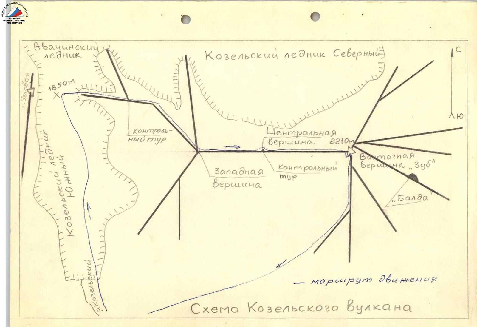
1. General description of the summit and its location.
Kozel'skaya sopka is part of the Avachinskaya group of volcanoes, located in the eastern part of the Kekhur ridge. The absolute height of Kozel'skaya sopka above sea level is 2210 m. It is an extinct volcano. Its slopes are composed of basalt and diabase. The slopes are generally gentle and mostly covered with a thick layer of slag. In the summer months, the pre-summit ridge is cleared of snow, exposing several gendarmes. However, snow persists on the slopes, even on the southern ones, throughout the summer. The northern slopes of the sopka are the walls of a large ancient crater, covered with ice and firn. These walls are densely strewn with basaltic "rock fingers".
The volcano has three peaks:
- Western,
- Central,
- Eastern.
The highest peak is the Eastern one, which is a rocky "tooth" rising 50 m above the general massif. The walls of the "tooth" are sheer on all sides. There is a non-wall passage along the south-eastern ridge (category 1B difficulty route). A glacier is located on the western side of the sopka (the glacier serves as a boundary between Avachinskiy and Kozel'skiy volcanoes), from which the Kozel'skiy stream flows. The foot of the volcano is heavily dissected by ravines. On the eastern side of the foot, there are quarries of construction organizations developing slag.
2. Approach to the ascent location.
a) Motorized transportation.
- Drive by car to the settlement of Rodygino (see map).
- You can take a regular bus to the settlement of Rodygino during the period from June to December.
- During the same period, there is car transportation available from Rodygino to Kozel'skiy stream, to a sopka resembling an iron, which bounds the stream on the right. The total travel time from the city to Kozel'skiy stream is 1.5 hours.
b) Hiking to the start of the ascent.
- From the end of the dirt road, exit to the right through a small sopka to Kozel'skiy stream.
- Kozel'skiy stream never dries up.
- On the left (in the direction of travel), the stream is bounded by a ridge of sopkas overgrown with stone birch and alder elfin wood; on the right are the spurs of Kozel'skiy volcano.
- After two hours of walking along the stream, it is recommended to set up a camp for the night at the end of a birch forest tongue located on the right bank of the stream bed.
- There is plenty of firewood and water available.
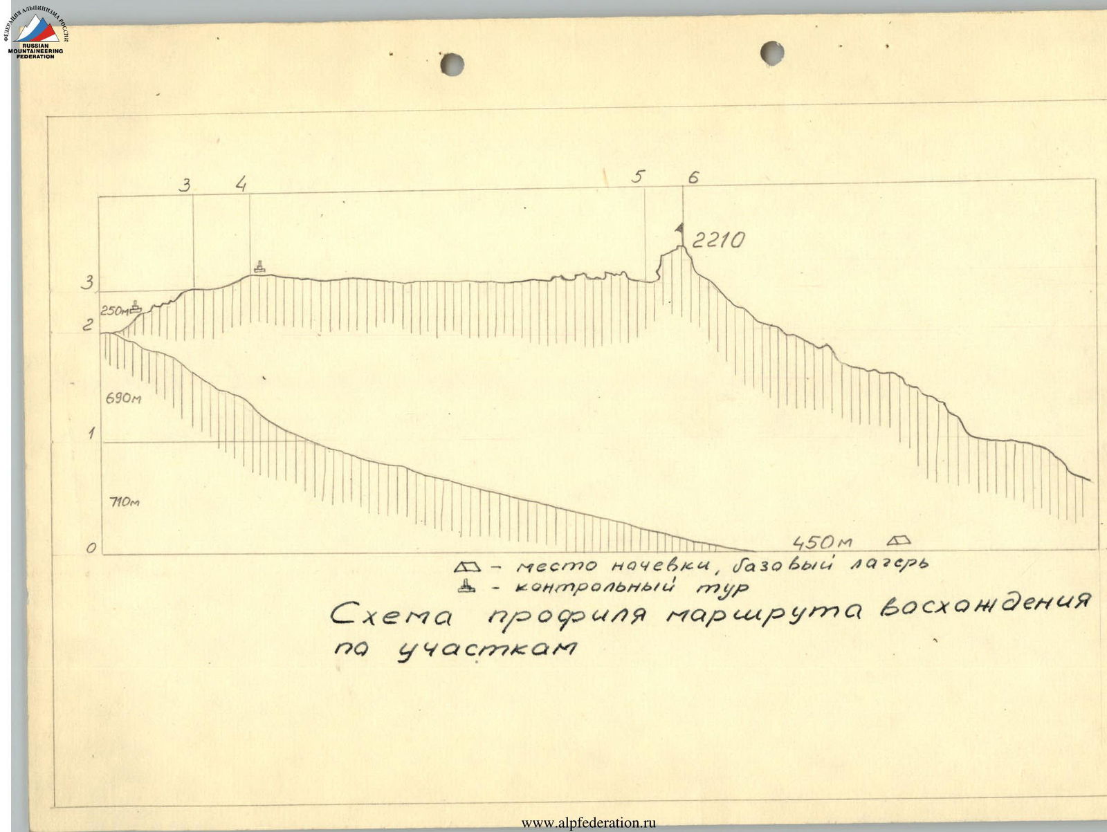
- The base camp is at an altitude of 450 m.
3. Route description by sections.
The total elevation gain from the start of the ascent to the summit is 1760 m.
R1
- Elevation gain 710 m.
- Slope angle 15°.
- The riverbed is of moraine character. The scree is medium and fine.
- In the last hour of the hike, the path is closer to Kozel'skaya sopka.
- Exit to the lower part of the glacier.
Travel time 2 hours 00 minutes.
R2
- Elevation gain 690 m.
- The slope angle at the beginning of the movement is 15°, further on it is 20–25°, and in some places up to 30°.
The glacier in its lower part is strewn with volcanic slag. After 150–200 m of ascent, it has the character of a closed glacier. There are transverse crevices. The exit to the upper glacier is a saddle between Kozel'skaya sopka and Uglovaya sopka. Movement is in rope teams. Insurance is simultaneous.
Travel time 4 hours 00 minutes.
R3
- Elevation gain 250 m.
- The ridge angle is 25°, in some places up to 40°; the exit to the Western peak is 30°.
The rocky ridge has medium and large scree. There are many low gendarmes, which are bypassed on the right (in the direction of travel) along the firn-ice slope. The exit to the Western peak is a snowy slope. The Western peak is composed of tuff.
Movement is in rope teams. Insurance is simultaneous and alternating through rocky outcrops. The exit to the Western peak is with alternating insurance through an ice axe (one rope).
Travel time 2 hours 30 minutes. After 1.5 hours of movement, there is a junction with a rocky ridge coming from the northwest. At this point, a cairn is installed as a control point.
R4
- Elevation gain 90 m.
- Steepness 40–45°.
- The ridge is snowy; when ascending to the Central peak, it becomes ice-firn.
Movement is in rope teams. Insurance is alternating with pitons when ascending to the Central peak.
Travel time 0 hours 40 minutes. From the Western peak, there is an exit along a wide snowy ridge into a vast hollow under the Central peak. To the peak - 2 ropes. Here is a control cairn, but in winter and until the end of July, it is under snow.
R5
At the end of the section, there is practically no height gain. The slope angle when bypassing gendarmes is 40–50°. The saddle between the Central peak and the "Tooth" of Kozel'skaya sopka is a rocky ridge (simple, loose rocks) with three gendarmes 6–8 m high.
Movement is in rope teams. Insurance is alternating when passing gendarmes (through rocky outcrops).
Travel time 0 hours 50 minutes.
R6
- Elevation gain 50 m.
- Steepness:
- 60–70° on the "tooth" wall;
- 40–50° on the summit ridge.
Firn, flow ice. Loose rocks of medium difficulty. Movement is in rope teams. Alternating insurance through rocky outcrops. Travel time 1 hour 00 minutes.
Bypass the "Tooth" of Kozel'skaya on the right (in the direction of travel) along firn and flow ice - 2 ropes. Exit under the "tooth" wall to the point of the greatest lowering of the massif. Ascent to the saddle of the South ridge - one rope. Along the saddle to the left and along the summit ridge - 3 ropes - exit to the summit. Here is a control cairn.
4. Descent from the summit.
Descent along the South ridge - category 1B difficulty route. Travel time 3 hours.
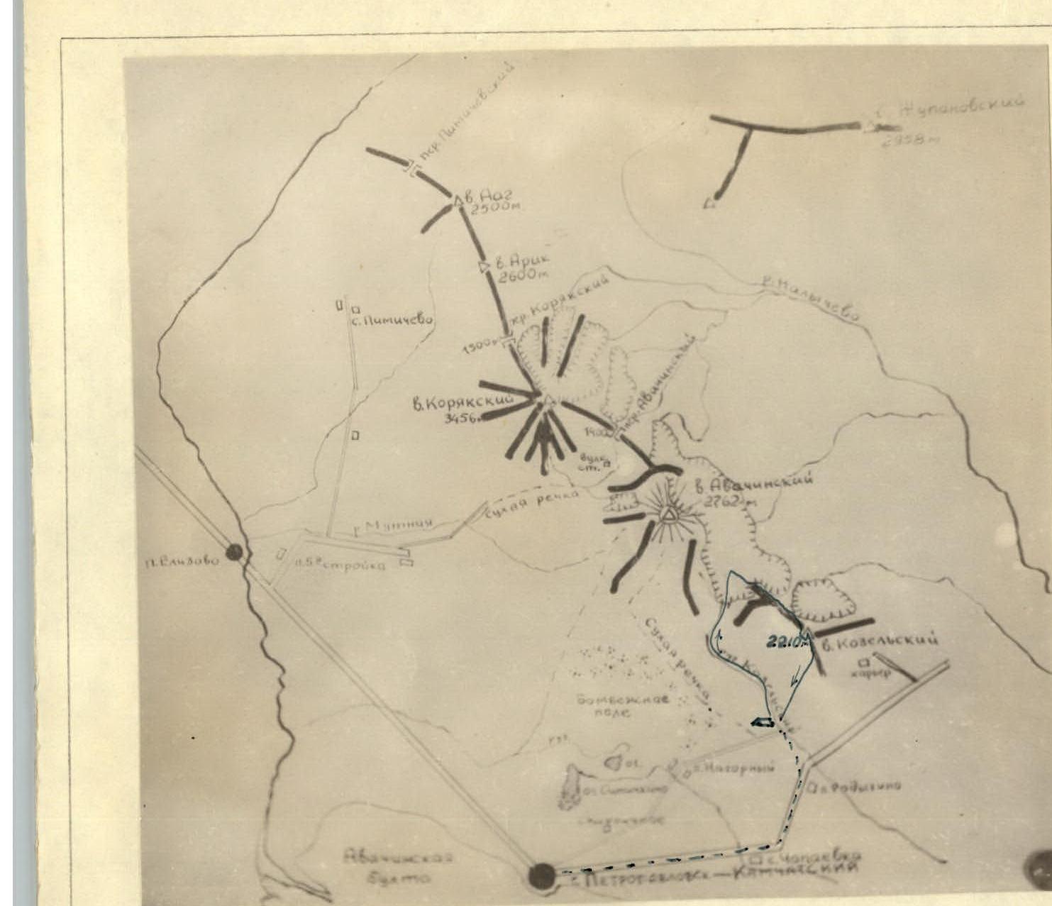
Map of the Avachinskaya group of volcanoes.
- — ascent route
- — movement route a) — base section to the pass
Protocol No. 269 dated 02.06.1967.
Ascent to the Tooth of Kozel'skaya sopka via the south-western edge - category 1B difficulty (Figure 4)
From Petropavlovsk-Kamchatskiy, drive by car towards the Pacific Ocean, in the direction of the settlement of Radygino and further beyond the settlement to the end of a large field - 2–2.5 hours.
On the right side of the field, on old forest roads, hike, keeping to the right along the forest boundary - 1–1.5 hours, in the direction of the pass between Uglovaya and Kozel'skaya, until you intersect with the valley of Kozel'skiy stream.
Follow the valley of Kozel'skiy stream for another 2–2.5 hours until the forest boundary, where the valley turns into a wide canyon with a view of the pass. At this point, on the stream bank - a bivouac. There is firewood and many good areas for tents. Overnight stay.
On the right side of the canyon, bypassing the boundary of the shrubbery, but not reaching the rocky massif, ascend to the right-bank moraine. Leaving the rocky massif on the left and crossing a wide avalanche-prone couloir on firn, exit after 1.5–2 hours to the south-western edge. Ascent to the edge is via heavily destroyed rocks. Along the edge, up to the left, on destroyed rocks with a steepness of 35–40° - exit under the wall (alternating insurance). The wall is 6 m (insurance), with many good handholds. Further ascent on destroyed rocks to a gap formed by a gendarme "Golova" and a lowering in the edge (Key section!). Descent from the gendarme to the saddle - 5 m, sport climbing method (pitons insurance). The saddle is narrow. In the first half of the summer, there may be a snow cornice on it (Be cautious during descent!). Along the saddle (1 rope) to the expanding part of the ridge and on rocks of medium difficulty (3 ropes) - exit to the summit (insurance through outcrops). Time to ascend from bivouac to summit - 6–7 hours.
Descent via the ascent route - 3–4 hours.
Recommendations for climbers:
- Number of participants - 6–8 people.
- Initial bivouac - Kozel'skiy stream canyon.
- Departure time from bivouac - not later than 5 am. The snowy couloir is avalanche-prone.
- Special equipment for a group of 4 people: a) main rope - 2×30 m; b) rock pitons - 4 pcs.; c) ice pitons - 1 pc.; d) carabiners - 6 pcs.; e) rock hammer - 1 pc.