22
ALPINISM GROUP ALP/KLUB "KUTH"
Material on the first ascent of the route: "peak Kozelsky via the western edge, category 2B difficulty"
The peak "Kozelsky" is located 20 km from the city of Petropavlovsk-Kamchatsky in a group of three peaks:
- peak "Koryakskaya sopka"
- peak "Avachinskaya sopka"
- peak "Kozelsky"
at 53° north latitude.
Ascent plan for peak "Kozelsky"
October 8, 19:00 - departure from the city and arrival at the glaciologists' hut. Overnight stay.
October 9, 7:00 - departure on the route and passage of the route, 13:00 - start of descent to the camp at the glaciologists' hut.
October 10 - return to the city.
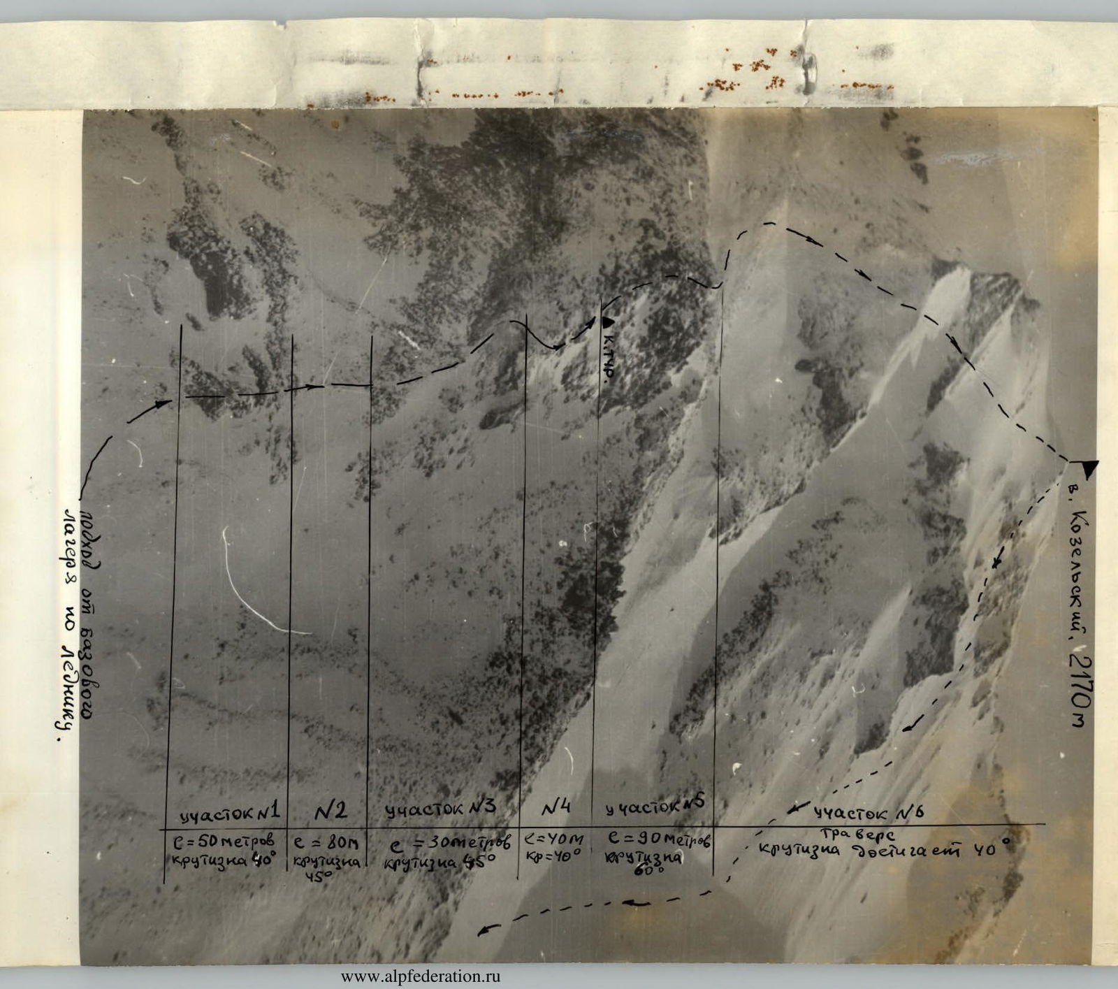
The approach to the route is made along the right moraine of the Kozelsky glacier. The glacier is open, movement is only along the moraine to the start of the route, taking 1.5-2 hours. From the glacier to the start of the rocky ridge of the route, there are 80-100 meters along the talus and snowy slope with a steepness of 45-50°.
R1 - length 50 meters
The section is rocky, rocks are partially covered with snow, steepness of the section is 45-40°. Insurance is provided by pitons and rock outcrops. The section corresponds to category 3. 1 rock piton is driven.
R2 - length 80 meters
Movement is simultaneous, the ridge is snowy and talus, steepness of the section is up to 45°. Corresponds to category 2.
R3 - length of the section 30 meters
Movement is along rocks with good holds (frozen lava flow), steepness of the section is up to 45°. The rock is monolithic, and pitons cannot be driven. In some places, ice screws are used, particularly in areas where the lava flow is stratified. The section corresponds to category 3. 2 ice screws are driven.
R4 - length of the section 40 m, steepness up to 40°
Simultaneous insurance, approach to the rocky ridge leading to a false pass. Corresponds to category 2.
R5 - length of the section 90 m, steepness 60-50°
Movement is with piton insurance and through outcrops, rocks are heavily snowed, with overhanging cornices and chimneys. Climbing is complex. Slabs are largely smooth and generally lack prominent holds. The section corresponds to category 3. 2 rock pitons are driven.
R6 - exit to the main peak
Movement is in crampons with simultaneous insurance on firm névé, steepness of some sections reaches 40-45°. The section corresponds to category 2. Length of the section is 450 meters.
Total route length is 740 meters.
Section lengths:
- category 2 difficulty = 570 meters
- category 3 difficulty = 170 meters
On the route, 3 rock pitons and 2 ice screws are driven.
List of participants and overall assessment of each:
- Neverov V.N. - 1st sports category
- Meltyukhov V.S. - 2nd sports category
- Akimov A.K. - 2nd sports category
- Korotaev P.N. - 2nd sports category
The western edge of peak "Kozelsky" was traversed by the group without errors; the group is physically and technically well-prepared.
List of equipment for 4 people:
- Main rope - 2 x 40 m
- Rock hammers - 2 pcs
- Rock pitons - 8 pcs
- Ice screws - 4 pcs
- Carabiners - 6 pcs
GROUP LEADER
Neverov
(V. NEVEROV)
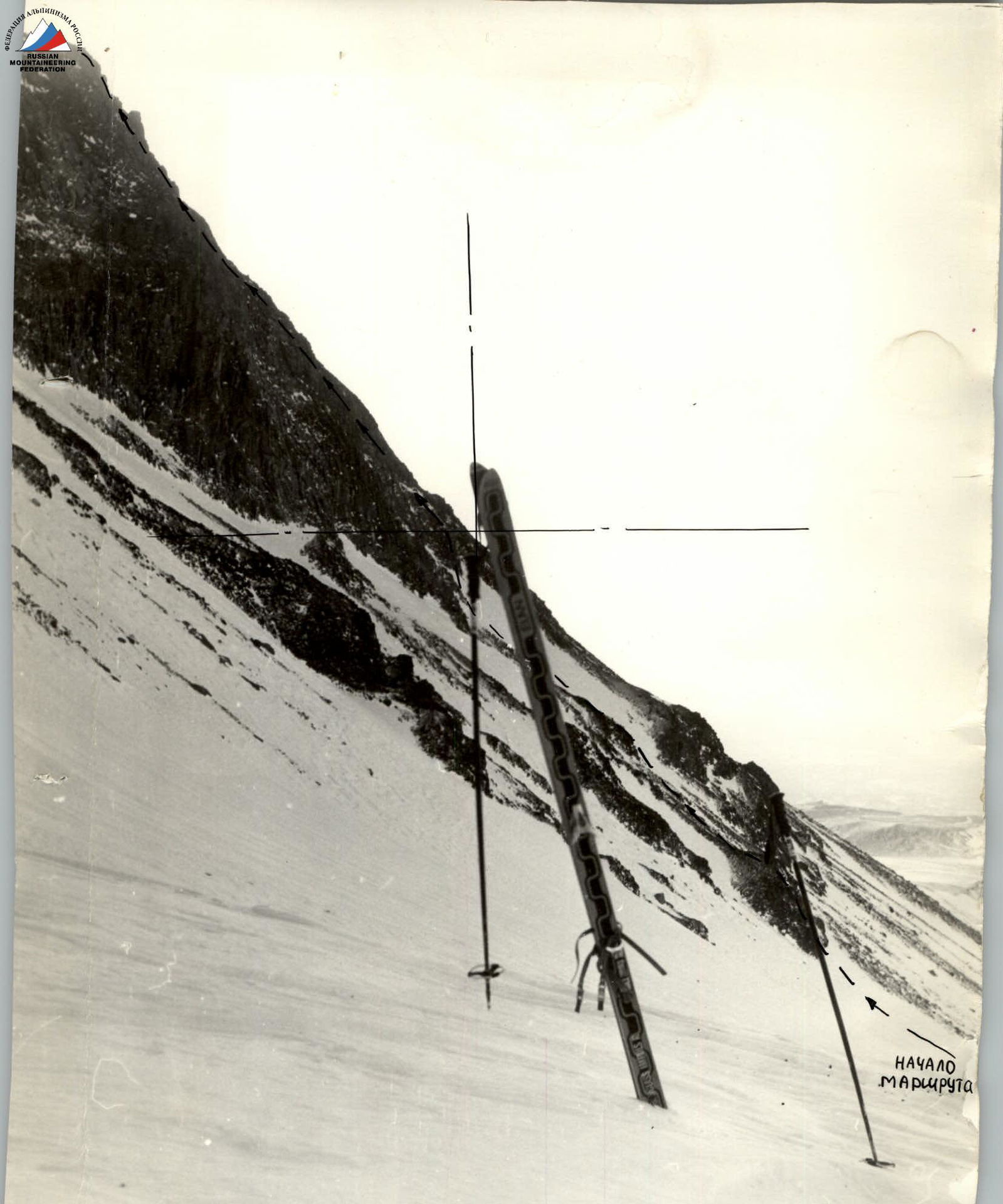
 Route profile from R1 to R5 section inclusive. Vertical - ski pole. General slope ≈ 45° 50°.