
Ascent Passport
- Ascent class — Traverse.
- Ascent area — Lesser Caucasus, Aragats massif.
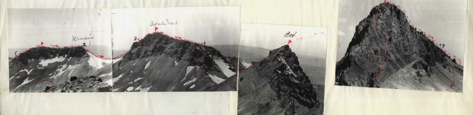
- Peak, ascent route — Aragats, traverse of Aragats South (3850 m) – Aragats West (3978 m) – Aragats Nameless (3800 m) – Aragats North (4095 m) peaks.
- Proposed difficulty category — 2A.
- Route characteristics: height difference — 800 m, average steepness — 35°.
- Number of pitons hammered for belay — 6 rock pitons.
- Number of travel hours — 10 h.
- There were no overnight stays on the route.
- Khachatryan Gagik Norikovich — leader, 2nd sports category, Avedyan Anatoly Dzerunovich — participant, 2nd sports category, Harutyunyan Ruben Gaykovich — participant, Candidate for Master of Sports, Mkrtchyan Roman Stepanovich — participant, 2nd sports category.
- Team coach — Khachatryan G.N.
- Departure to and return from the route — September 2, 1977.
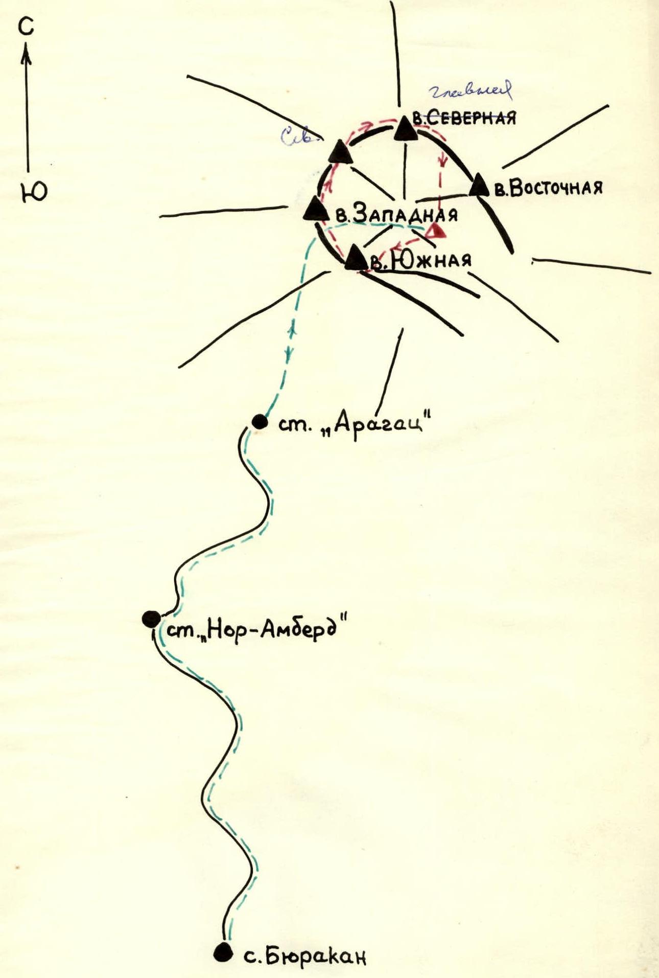
Map of the Aragats massif
Approach to the route
From the village of Byurakan, Armenian SSR, follow the road to the high-altitude stations "Nor-Amberd" and "Aragats". From the "Aragats" station, bypassing Lake Kari-lich to the left, traverse the slope of the crater cone in a northerly direction, approach the saddle between Aragats South and Aragats West peaks, and descend into the crater from there. Overnight stay in the crater near the spring.
| nature of the section | belay | passage | ||||||||
|---|---|---|---|---|---|---|---|---|---|---|
 |  | average steepness in degrees |  |  |  |  | weather conditions |  |  |  |
| :------------------------------------------------------------------------------------------------------------------------------------------------------: | :------------------------------------------------------------------------------------------------------------------------------------------------------: | :-------------------------------: | :------------------------------------------------------------------------------------------------------------------------------------------------------: | :------------------------------------------------------------------------------------------------------------------------------------------------------: | :------------------------------------------------------------------------------------------------------------------------------------------------------: | :------------------------------------------------------------------------------------------------------------------------------------------------------: | :----------------: | :------------------------------------------------------------------------------------------------------------------------------------------------------: | :--------------------------------------------------------------------------------------------------------------------------------------------------------: | :--------------------------------------------------------------------------------------------------------------------------------------------------------: |
| 1 | 2 | 3 | 4 | 5 | 6 | 7 | 8 | 9 | 10 | 11 |
| Date | Designation | Average steepness in degrees | Length in m | Terrain characteristics | Difficulty | Condition | Weather conditions | Number of rock pitons | Nature of movement | Time taken |
| :------------------------------------------------------------------------------------------------------------------------------------------------------: | :------------------------------------------------------------------------------------------------------------------------------------------------------: | :-------------------------------: | :------------------------------------------------------------------------------------------------------------------------------------------------------: | :------------------------------------------------------------------------------------------------------------------------------------------------------: | :------------------------------------------------------------------------------------------------------------------------------------------------------: | :------------------------------------------------------------------------------------------------------------------------------------------------------: | :----------------: | :------------------------------------------------------------------------------------------------------------------------------------------------------: | :--------------------------------------------------------------------------------------------------------------------------------------------------------: | :--------------------------------------------------------------------------------------------------------------------------------------------------------: |
| September 11, 1977 | R1 | 25 | 800 m | slope | 1 | fine scree | clear | simultaneous movement | simultaneous movement | 1.5 h |
| -«- | R2 | 30 | 600 m | ridge | 2 | broken rocks | -«- | -«- | -«- | 0.5 h |
| -«- | R3 | 40 | 300 m | slope | 2 | broken rocks, firn | -«- | ledges | sport descent | 0.5 h |
| -«- | R4 | 40 | 400 m | ridge | 2 | broken rocks | -«- | -«- | free climbing | 1 h |
| -«- | R5 | 25 | 1200 m | ridge | 2 | broken rocks, scree | -«- | simultaneous movement | simultaneous movement | 3 h |
| -«- | R6 | 60 | 100 m | wall | 3 | broken rocks, rockfall | -«- | 4 pitons, ledges | free climbing | 3 h |
| -«- | R7 | 40 | 120 m | ridge | 2 | broken rocks | -«- | 2 pitons, ledges | -«- | 2 h |
Comments
Sign in to leave a comment