Tfan Glavny via NW slope and NE ridge. Singin D.G. Eastern Caucasus, November 2, 1810
PASSPORT
-
Character of the route — combined
-
Eastern Caucasus, Makhmudchai River valley
-
Tfan Glavny via North-Western slope and North-Eastern ridge
-
Claimed 2A cat. dif. — first ascent
-
Elevation gain — 690 m, length — 1540 m
Length of sections:
- 2 cat. dif. — 600 m
- 3–4 cat. dif. — 15 m
Average steepness of the main part of the route — 45°
-
Duration — 5 hours
-
Leader — Singin Dmitry Gennadievich
Participants:
- Ragimov Elman Mubariz oglu
- Mamedov Elchin Soltan oglu
-
Coach — Dzhafarov Rasim Pashayevich
-
Departure — summit — return — September 19, 1994
-
Organization — Azerbaijan Republican Mountaineering Club
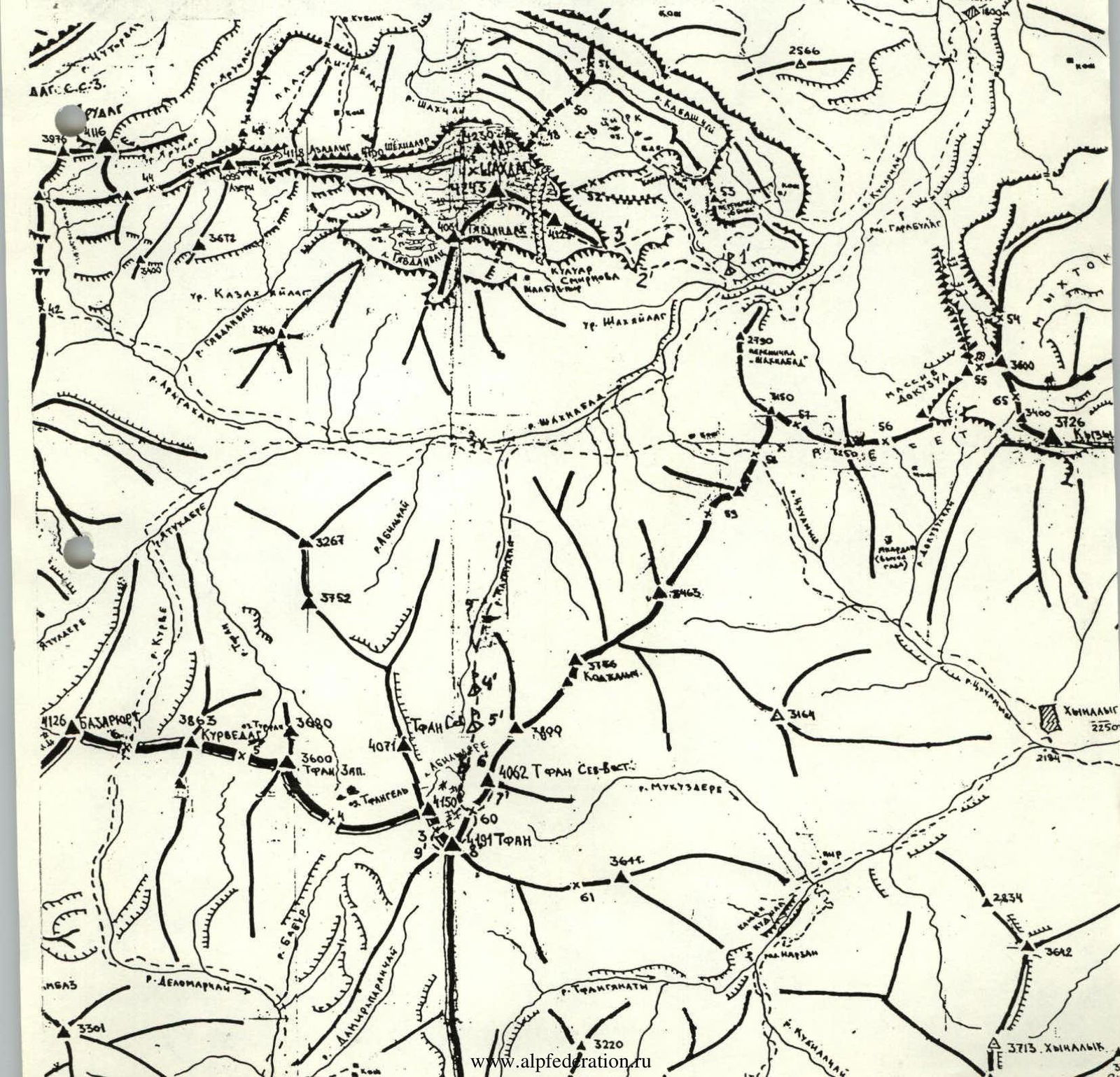
1'. Shakhdag campsites 2. Route on Shakhdag peak via the 3rd bastion, 5A cat. dif. 3. Route on Shakhdag peak via NE slope, 2B cat. dif. 4'. Lower Tfan campsites 5'. Upper Tfan campsites 6'. "Tsirk" campsites 7. Route on Tfan peak via NE slope and Southern ridge, 2B cat. dif. 8. Route on Tfan Glavny via NW slope and NE ridge, 2A cat. dif. 9. Route on Tfan Glavny via NE wall, 3B cat. dif.
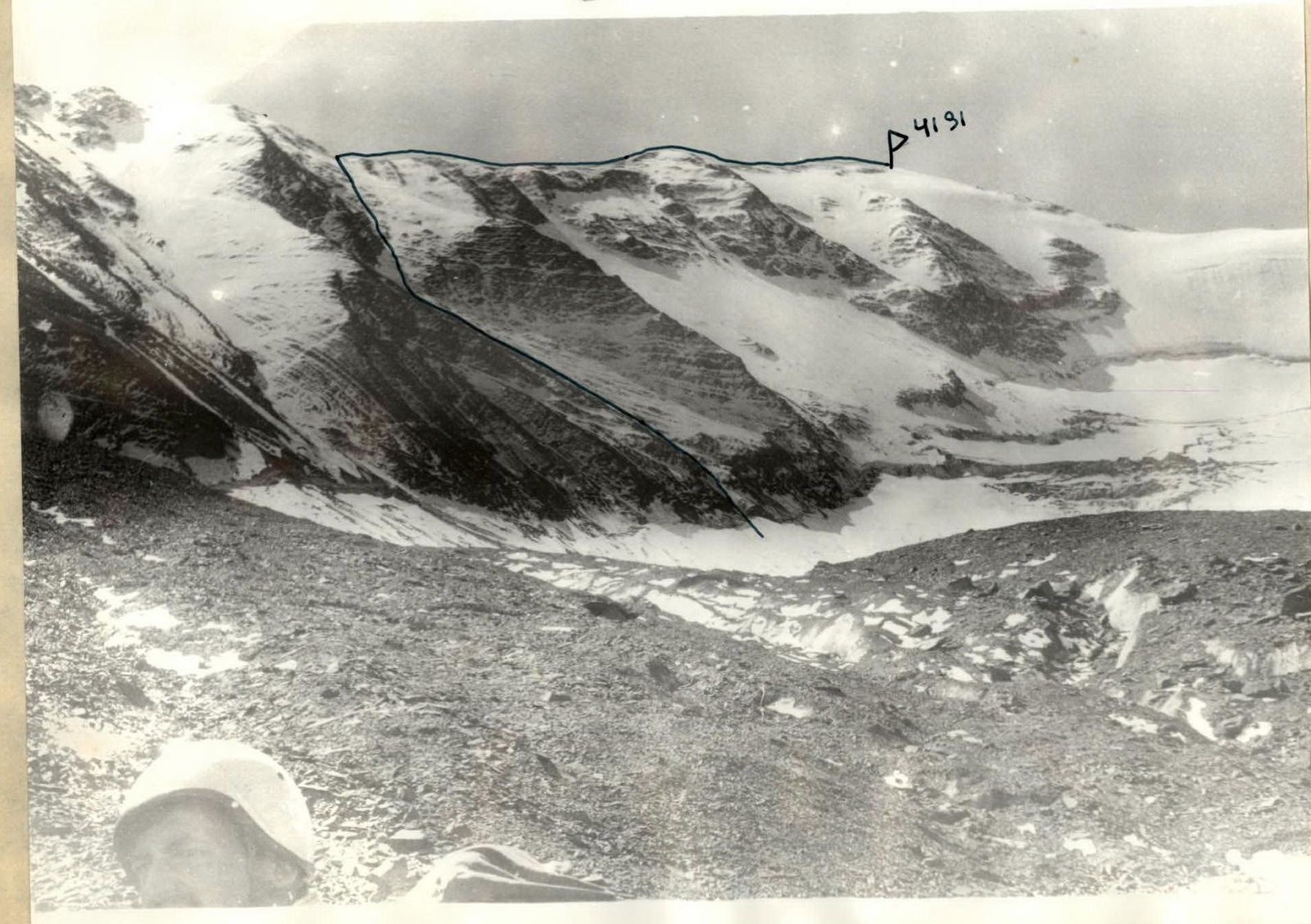
 Tfan Glavny (4191 m) via North-Western slope and North-Eastern ridge. 2A cat. dif.
Brief Description
From Kuzun village, follow a dirt road to Laza village (about 7 km). From Laza village, follow a good trail on the left side of the Kusarchai River, then along the Shakhnabad River to the entrance to the Shakyaylag tract. From Kuzun village — 8–9 hours.
From the entrance to the tract, move:
- along the left side (in the direction of travel) of the Shakhnabad River,
- then along the left side of the Makhmudchai River.
Reach the end of the grassy slopes. Convenient campsite (Lower Tfan campsites). From the entrance to the Shakyaylag tract to the Lower Tfan campsites — 2–2.5 hours.
From the campsite, move up the valley along the left side of the river, reach the rocky glacier and proceed to the waterfall. There is a place for several tents. From the Lower Tfan campsites — 40 minutes.
From the waterfall:
- bypassing gentle rocks on the left, reach a weakly defined col (600 m);
- Upper Tfan campsites;
- from Lower to Upper Tfan campsites — 2–3 hours.
Further:
- along the glacier, covered with small scree (some areas have exposed ice), following the left rocky ridge, move towards the central part of the glacier;
- approach the bergschrund in its middle part (400 m, 30–40°);
- cross the bergschrund via an ice bridge;
- then, along gentle, broken rocks and exposed glacier upwards (100 m, 30–35°);
- along the rocky glacier, reach the cirque (500 m, 10–20°);
- "Tsirk" campsites;
- from Upper Tfan campsites — 2–3 hours.
From the "Tsirk" campsites:
- move along the rocky glacier towards Tfan Glavny peak (300 m, 0°);
- "Approach the exposed part of the glacier. Start of the route."
Then, moving towards the left edge, along the way, to Tfan Glavny peak, reach the randkluft — 150 m, 20°, 1 cat. dif.
Cross the randkluft via an ice bridge — 15 m, 60°, 3–4 cat. dif. Protection via ice screws.
Further:
- along a weakly snow-covered scree slope,
- in some areas, along strongly broken rocks — 600 m, 40–50°, 2 cat. dif., reach the ridge.
Follow the easy ridge towards the summit — 750–800 m, 15°, 1 cat. dif.
From the start of the route to the summit — 5 hours.
Descent follows the path down