Bazaryurt, via the 2nd buttress of the NW wall Mamedov E.S. Eastern Caucasus 2.11.6
Passport
- Character of the route — combined
- Eastern Caucasus, YatukhDere, Shakhnabad, Kusarchay gorges
- Bazaryurt via the 2nd buttress of the NW wall
- Claimed category — 4A — first ascent
- Height difference — 865 m, length — 1600 m. Length of the sections of 4–5 cat. — 440 m. Average steepness of the main part of the route — 43°.
- Duration — 10 hours
- Leader — Mamedov Elchin Soltan ogly Participants — Asadov Yakub Aliaga ogly
- Coach — Jafarov Rasim Pashaevich
- Departure — summit — return — August 29, 1993
- Organisation — Azerbaijan Republican Mountaineering Club
Mt. Bazaryurt (4126 m) via the 2nd buttress of the NW wall. Cat. 4A.
Brief Description
From Kuzun village, follow a dirt road to Laza village (about 5 km). From Laza village, take a good trail on the left bank of the Kusarchay River, then follow along the Shakhnabad River to Shakhyaylag. Cross the Shakhnabad River via a bridge. From Kuzun village to the bridge — 9–12 hours.
Continue upstream on the right bank of the Shakhnabad River. Cross a river flowing from the Kurush pass. Then continue upstream on the right bank of the YatukhDere River. About 200–300 m before the Yatukh pass, there is a good campsite on a grassy clearing at the foot of a rocky hill. From the bridge to the campsite — 6–8 hours.
It is possible to pass through the upper part of the YatukhDere River along its left bank (crossing the river via a snowfield). There is a good trail from the bridge to the Yatukh pass.
From the campsite, cross the YatukhDere River via a snowfield. Then traverse the slope of the NW wall with a slight gain in altitude. After traversing two snow couloirs and simple rocks leading to them, approach the beginning of the 2nd buttress — the start of the route. Approach from the camp: 40–50 minutes.
If the bivouac is located on the "Narzan" clearing near the stream (see map), it is possible to approach the route from below via:
- a snow couloir,
- simple rocks.
500 m, 30–40° steepness.
The buttress is climbed mainly along the ridge and the left slope of the buttress. A control cairn is located at the end of the 13th section (according to the UIAA route map), upon reaching the ridge.
After passing the hanging glacier of the NW wall:
- move to the right to bypass three rocky outcrops;
- cross a snow plateau;
- reach the pre-summit ridge;
- follow the pre-summit ridge to the summit (the 1st rocky outcrop is the summit).
From the start of the route to the summit — 10–12 hours.
Descent via the NW ridge route, cat. 1B. Note: there are many loose rocks along the entire section of the route on the buttress.
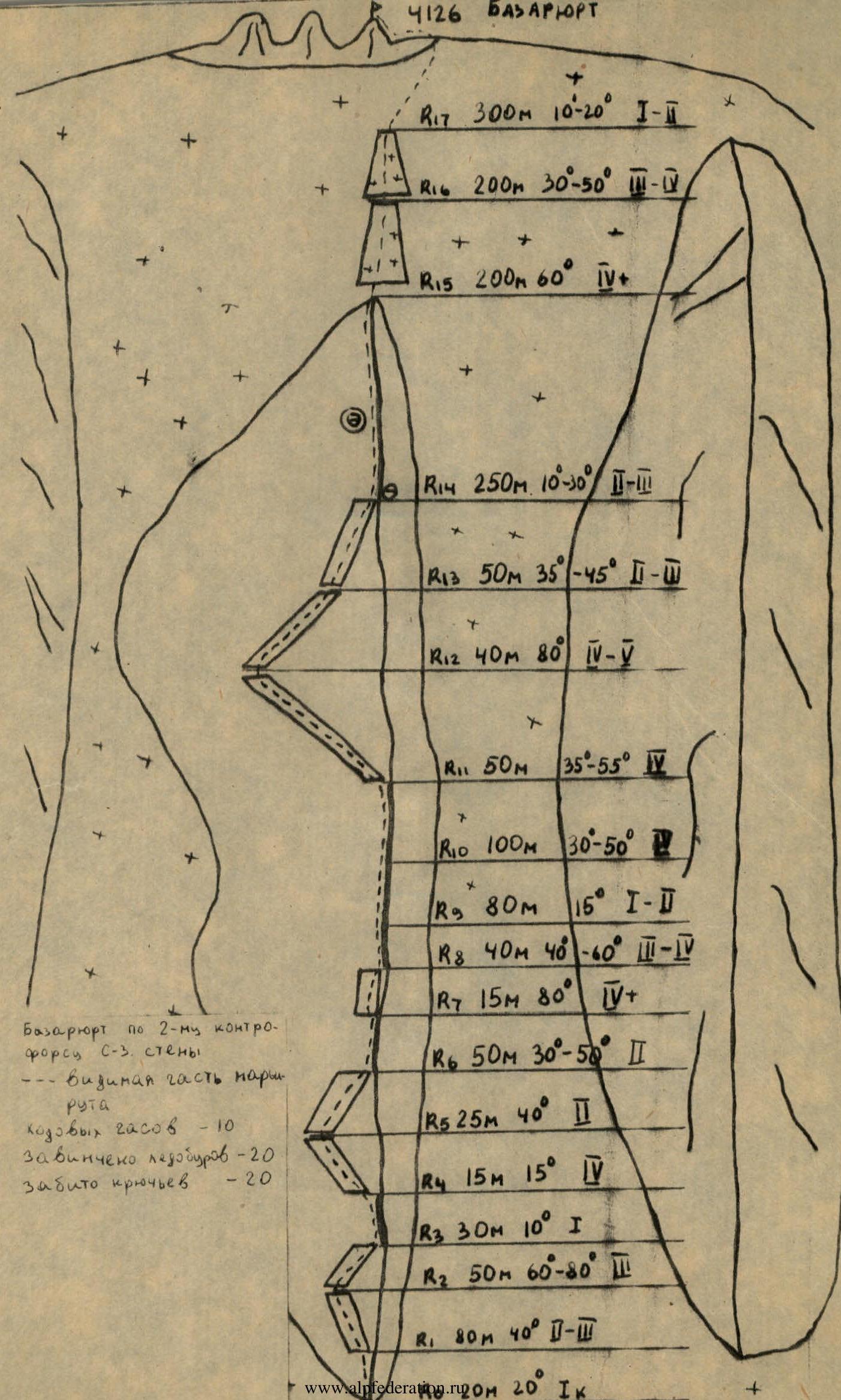
Route Diagram for Bazaryurt (4126 m) via the 2nd buttress of the NW wall
- R1: 80 m, 40°, 2–3
- R2: 50 m, 60–80°, 3
- R3: 30 m, 10°, 1
- R4: 15 m, 15°, 4
- R5: 25 m, 40°, 2
- R6: 50 m, 30–50°, 2
- R7: 15 m, 80°, 4+
- R8: 40 m, 40–60°, 2–4
- R9: 80 m, 15°, 1–2
- R10: 100 m, 30–50°, 2
- R11: 50 m, 35–55°, 4
- R12: 40 m, 80°, 4–5
- R13: 50 m, 35–45°, 2–3
- R14: 250 m, 10–30°, 2–3
- R15: 200 m, 60°, 4+
- R16: 200 m, 30–50°, 2–4
- R17: 300 m, 10–20°, 1–2
Summary Information on the Route
- Bazaryurt via the 2nd buttress of the NW wall
- — visible part of the route
- Duration — 10 hours
- Ice screws used — 20
- Pitons used — 20