
I. Category of first ascent. 2.2.10. Dagestan Mountains, South Dagestan, Shalbuzdagsky ridge.
-
Shalbuzdag Northwest, 4000 m, via the terrace of the West wall, rock route.
-
Proposed: first ascent, category 3B complexity (first ascent attempt).
-
Route characteristics:
- Elevation gain: 300 m.
- Length of sections:
- 2nd category complexity — 550 m.
- 3rd category complexity — 200 m.
- 4th category complexity — 90 m.
- 5th category complexity — 10 m.
- Total route length: 850 m.
- Average steepness of the right part of the 3rd wall: 45°.
- Number of rock pitons hammered: 7/0.
Number of used chocks: 9/0. Number of pitons left on the route (on descent): 9.
- Climbing hours — 6.
- No overnight stays on the route. Overnight stay in the jump-off camp, on the southern slope of the Shalbuzdag massif, in a grotto of the lower rock belt, 3800 m.
- Leader: Konstantin Eduardovich Dorro, Candidate for Master of Sports.
Team members:
- Maximov Vladimir Vladimirovich, 2nd sports category
- Shanavazov Shanavaz Eldarovich, Candidate for Master of Sports.
- Departure to the route, ascent to the summit, and return on March 30, 1992. II. Organization: Mountain club "Eos".
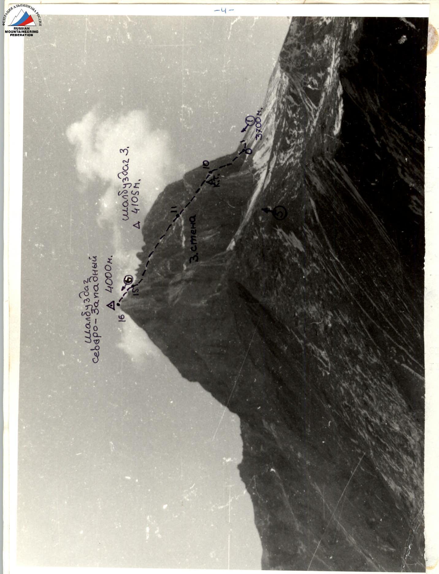
Photo 0: General view of the Shalbuzdag Northwest summit. The team's route: via the terrace of the West Wall. Category 3B complexity. Photo taken in October 1985. Number "O" on the area map, with h ≈ 3000 m, l ≈ 6 km.
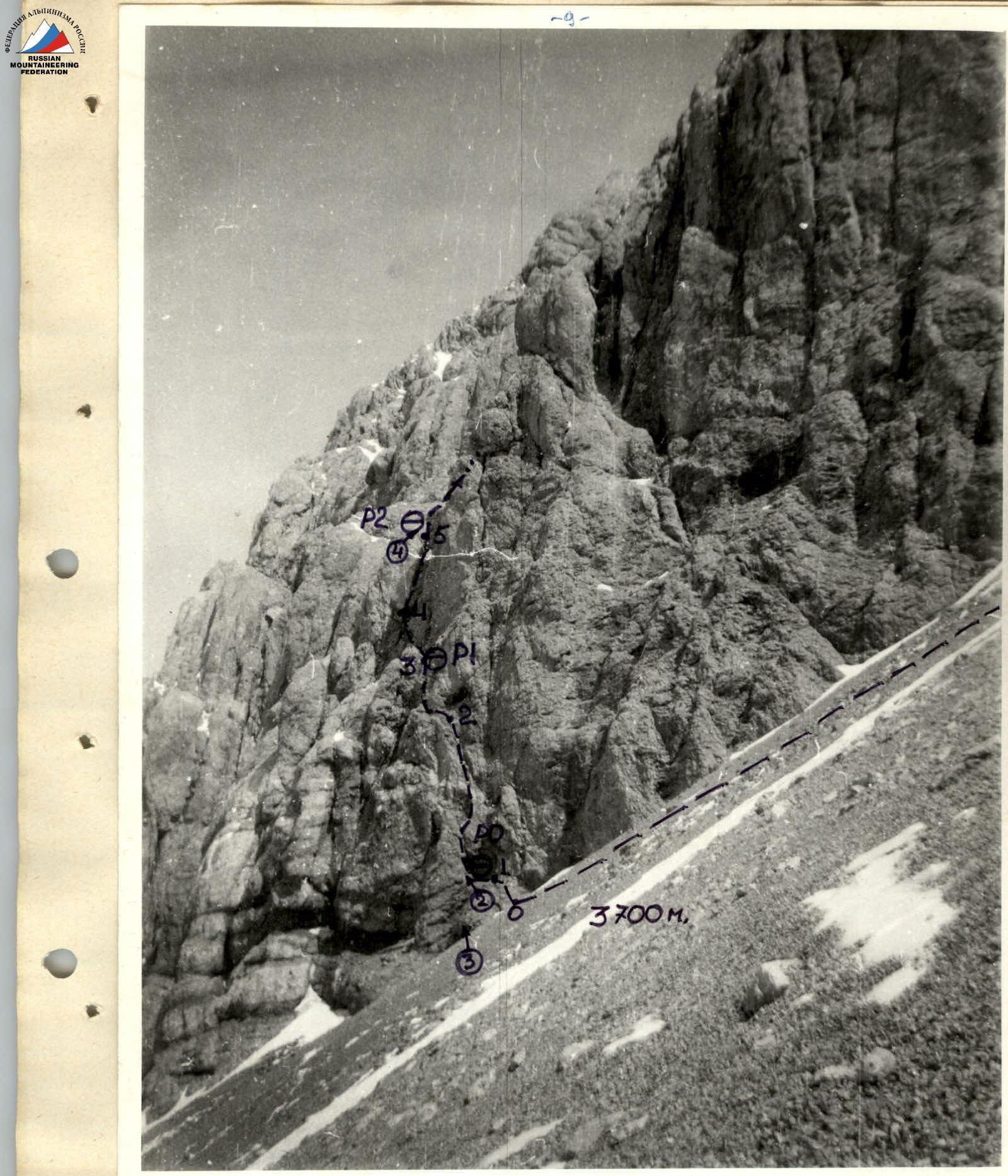
Photo 1: Right part of the 3rd wall. Start of the route. Sections R0–R5. Photo taken on March 30, 1992.
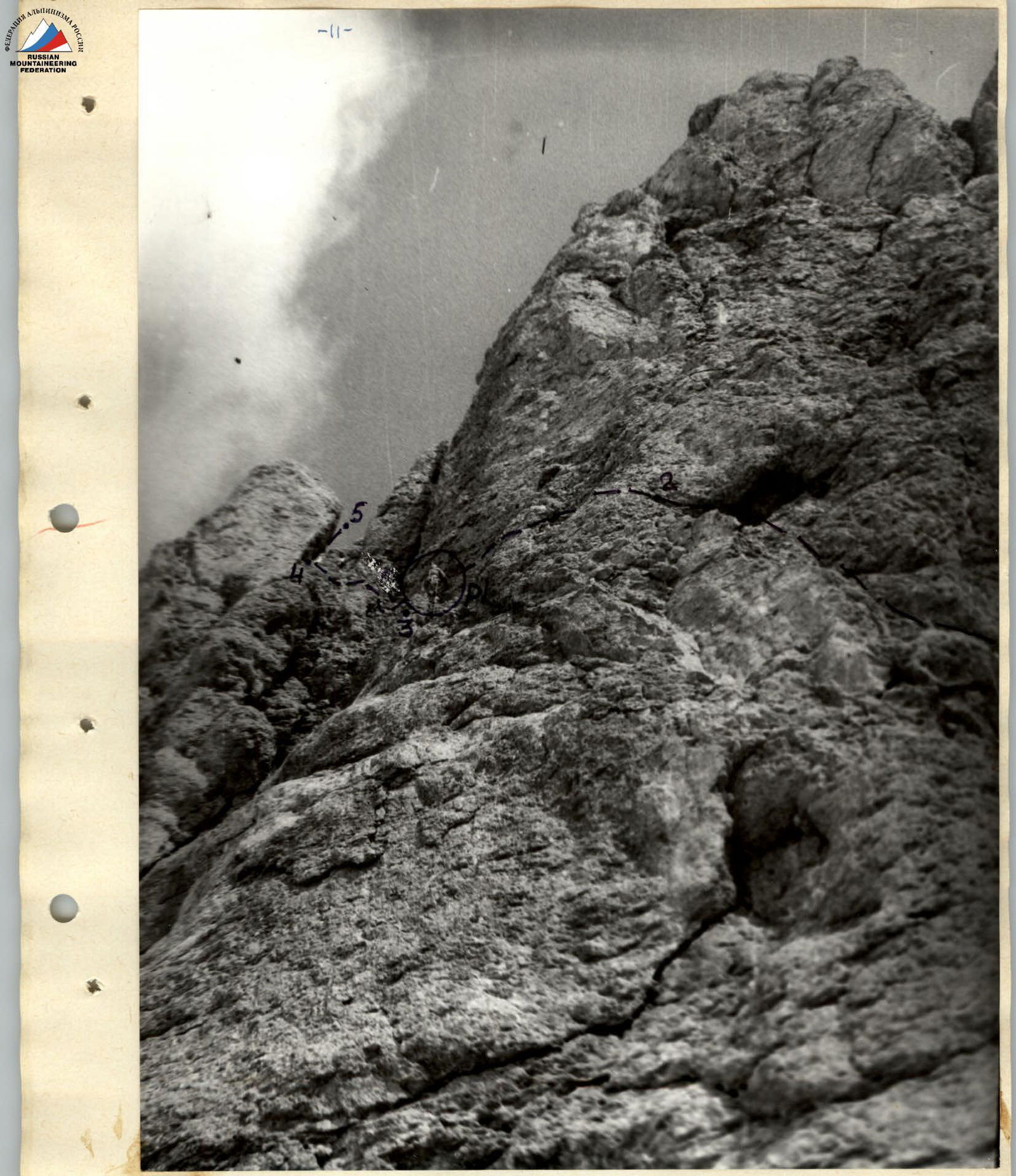
Photo 3: Lower part of the route. Sections R2–R5 and R1. Taken from the scree.
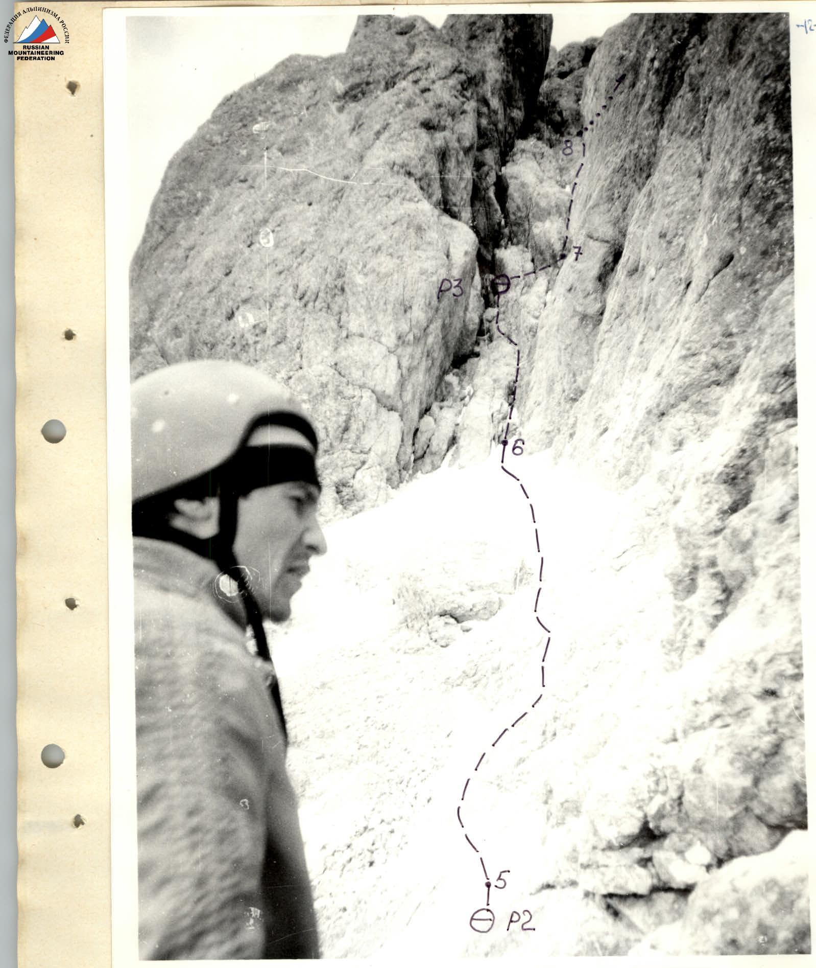
Photo 4: Shelf and crack-chimney. Sections R5–R8. Photo taken from R2. Shanavazov Sh. E.
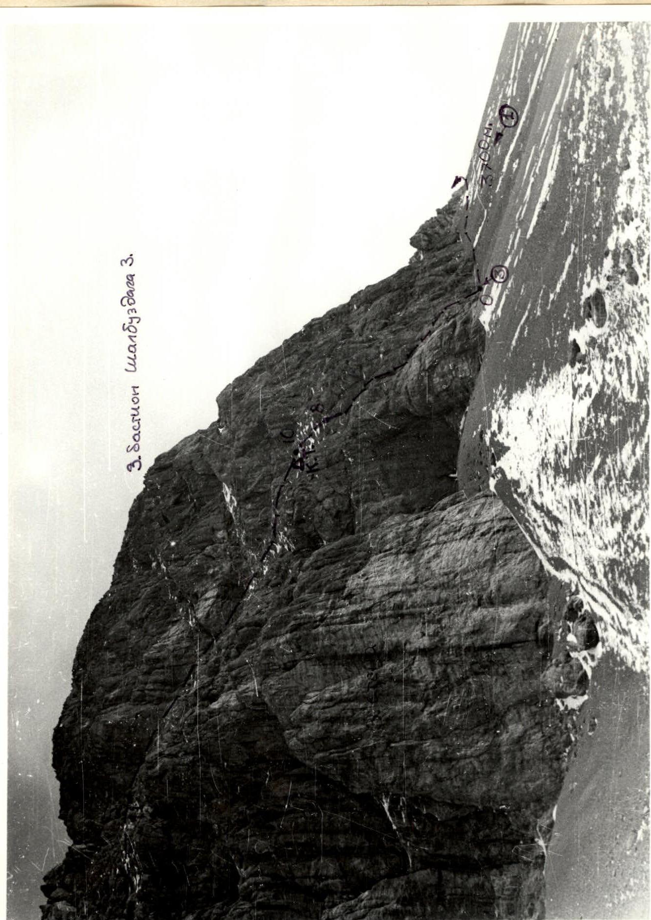
Photo 5: Right part of the 3rd wall and the terrace. Sections R0–R11. Taken from h ≈ 3450 m, l ≈ 1.5 km.
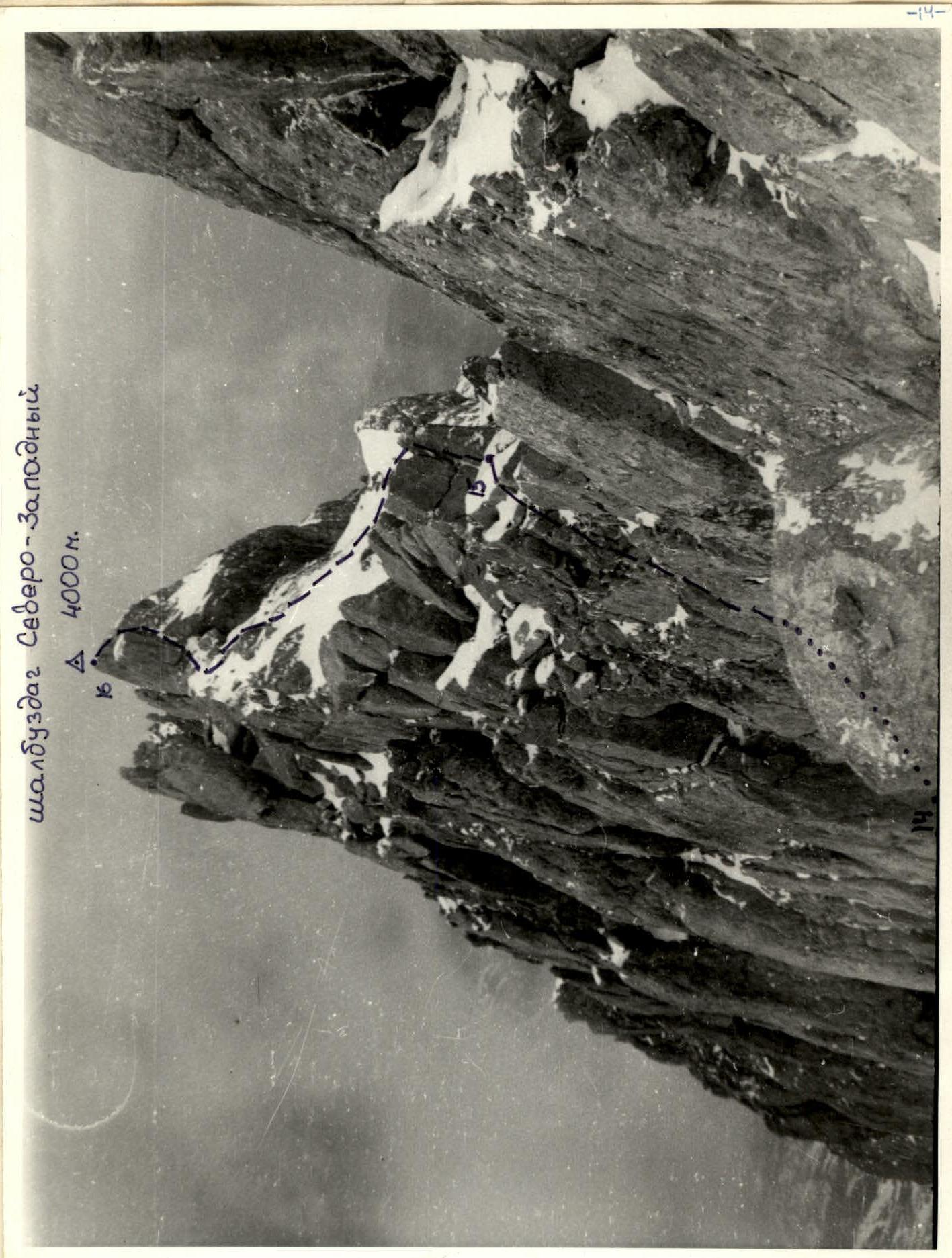
Photo 6: Summit and pre-summit ridge. Sections R14–R16. Photo taken from the point reached by the team during the ascent. The wall of the left gendarme and the "saw" of the NW ridge of Shalbuzdag W are visible.
Approach to the route description
From the village of Kurush (2500 m, SE slope of Shalbuzdag) in the Akhtynsky district of Dagestan, go down the road towards the village of Usukhchai, about 400 m, and at the first stream, near a clay remnant, exit onto a cattle trail, follow it to the right – up to a characteristic saddle on the ridge (40 minutes). From it, the entire further approach is visible.
From the saddle, descend into a marshy lowland and then along the ridges and hills of the SE slope of Shalbuzdag approach the second, left, couloir cutting through the lower belt of rocks (5 hours from the village of Kurush).
On the right side of the couloir, 100 m from the base:
- "Grotto" overnight stay
- in the grotto, there is a place for a tent and two more on the shelf near the entrance.
From the grotto, move west (left), traversing under the walls of Shalbuzdag. The exposure of the wall changes from southern at the grotto to western under the col between the Main and West Shalbuzdag peaks.
On the traverse:
- stay close to the wall
- under the col, do not gain height following the wall (conglomerate scree, sheep's backs).
Approach the West bastion of Shalbuzdag W and move along the wall with a drop of about 100 m height. Gradually, bypassing the bastion (the wall becomes "western" again), and not reaching the visible turn of the wall around the corner, looking like a "claw", about 50 m, stop.
On the "roof" of the wall, the beginning of the terrace is visible. To the right in the wall, 8 m from the scree, there is a three-meter niche. This is the start of the route.
From the "Grotto" overnight stay — 1.5 hours.
Route description
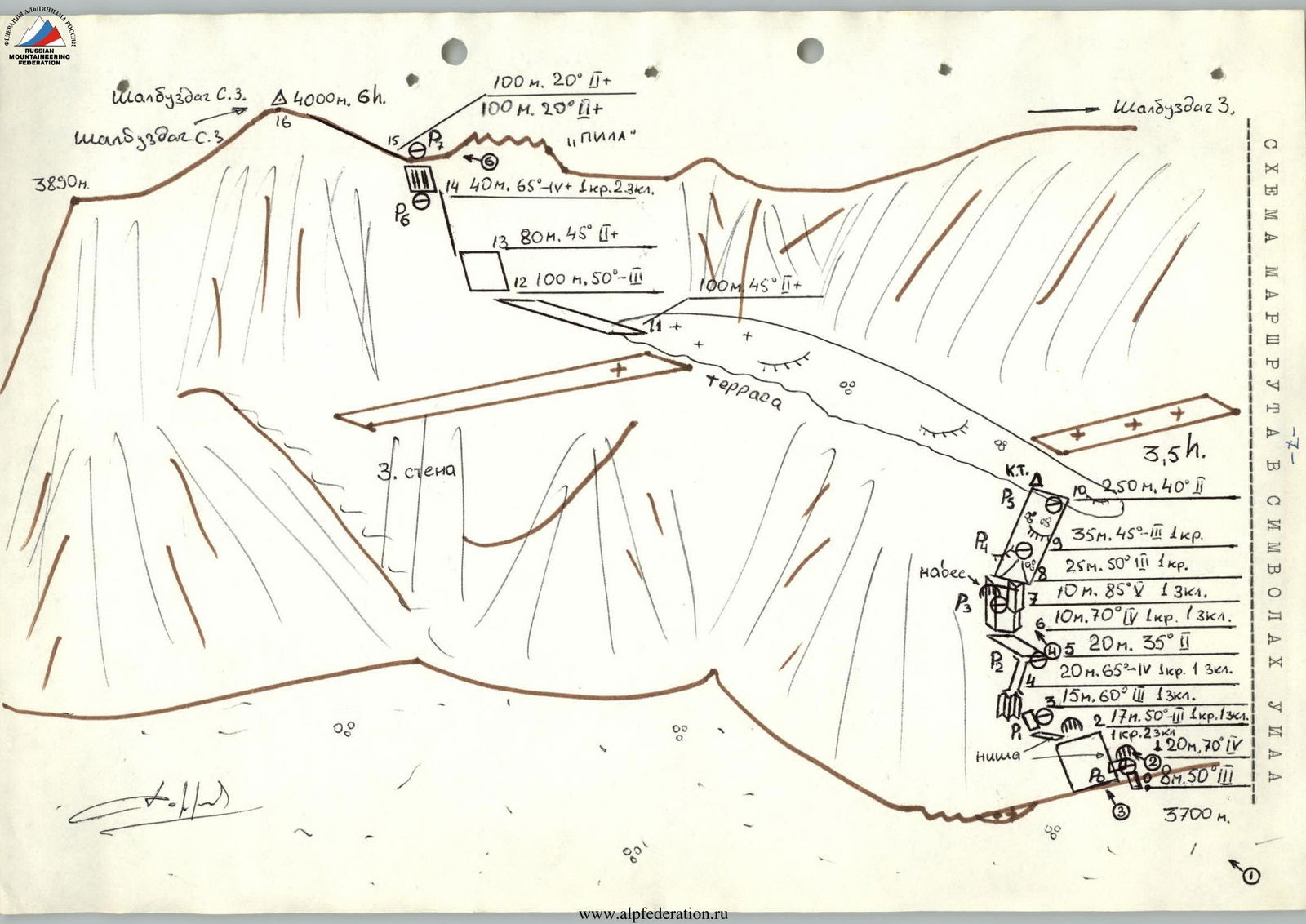
The ascent route to Shalbuzdag NW passes along the terrace of the W wall. The terrace starts in the right lower part of the W wall under the NW wall of the W bastion of Shalbuzdag W and crosses the entire wall diagonally left – up at an angle of about 30°. The terrace, tapering off, leads under the col between Shalbuzdag NW and the "saw" of the NW ridge of Shalbuzdag W. Two large shelves lead to the terrace: one, going to the right, cuts through the middle of the W bastion of Shalbuzdag W and, apparently, should lead down under the col between the Main and West Shalbuzdag peaks. Descent via this route is possible. However, the team decided to descend via the ascent route due to lack of time for reconnaissance. The second shelf goes left with a drop in height and ends in the middle of the W wall, approximately on the same vertical as the summit. The ascent to the terrace passes along the left part of the drop connecting the W wall of Shalbuzdag NW with the wall of the W bastion of Shalbuzdag W. The start of the route: a characteristic niche in the wall, 8 m from the scree. From it, move along rocks of medium complexity towards the visible niche 20 m away. Turning left, go around the corner along a narrow shelf to a system of inner corners, here R1 (sections R0–R3). Along the wet inner corner and further along the wide chimney (sections R3–R5), enter the scree shelf (R2), along it (sections R5–R6) approach the crack-chimney. The shelf goes left around the corner (leads to drops). Up the crack-chimney, in its middle R3, the complexity increases. From R3, move right 3 m "around the belly" and along the right part of the crack, along the steep inner corner (sections R7–R8), enter the slope leading to the terrace, sheep's backs (Caution! Crumbly rocks and stones on the backs) (sections R8–R10). At R5, on the left on a stone, there is a control cairn. Further along the terrace to the left, without going under the rocks, walk towards the left edge of the wide part of the terrace, underfoot the depression breaks off onto the walls. The terrace becomes narrower and, turning around the corner, turns into a system of shelves and rock steps (sections R10–R12). General direction left – up. Steepness increases, the rocks are rich in relief, walk towards the visible gendarmes on the ridge (sections R12–R13). Move left, enter a vaguely expressed rib (sections R13–R14). To the left, there is a drop into a rock depression starting from under the col between NW and W Shalbuzdag. From the rib, along shelves and slabs, move left under the col (stretches to the right) R6. Along a slab with cracks (sections R14–R15), exit onto the col (R7) to the left of the leftmost gendarme of the NW ridge of Shalbuzdag W. Further along the ridge made of slabs and large-block rocks (Drops!). Reach the summit of Shalbuzdag NW (4000 m). On sections R10–R14, movement is with protection on ledges. Caution, drops underfoot. The team, when reaching the col, missed it, went too far to the right, and did not have enough time to bypass the last gendarme before the pre-summit ridge. And the summit remained unconquered. Descent is via the ascent route to the control cairn. Further 4 rope lengths descend onto the scree. The last 2 lead to the right of the ascent line (orographically). The return to the grotto takes more time due to gaining height on the scree under Shalbuzdag W.
Comments
Sign in to leave a comment