72
Ascent Passport
- Climbing category: ice
- Climbing area according to KTMGV: Eastern Caucasus (2.9)
- Peak, its height, and ascent route: p. M. Gadjieva 4073 m, from the glacier along the northern ridge
- Estimated difficulty category: 3A
- Route characteristics: height difference 600 m, average steepness 30°, length of sections: R1 – 100 m; R2 – 180 m; R3 – 250 m; R4 – 130 m; R5 – 150 m; R6 – 160 m; R7 – 220 m; R8 – 40 m; R9 – 40 m.
- Number of anchors for belay:
- rock anchors — 0
- ice anchors — 18
- bolt anchors — 0
- Number of travel hours — 5.5–6
- Number of nights and their characteristics — none
- Surname, name, patronymic of the leader and participants, their sports qualification:
- Svyagin A.K. — MS
- Kudryavtsev A.I. — 2nd sports category
- Malikov Yu.B. — 2nd sports category
- Smotrov A.I. — 2nd sports category
- Smotrov S.I. — 2nd sports category
- Gerasimov M.I. — 2nd sports category
- Team coach — Gadjiev K.I. — MS
- Date of departure and return — October 7, 1981
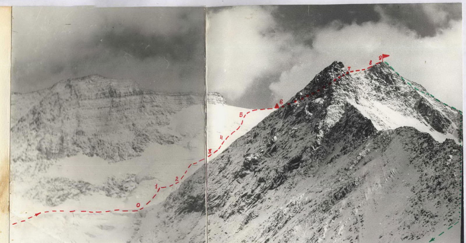
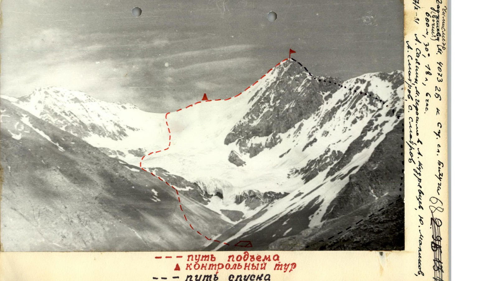 Caption for the image: ascent path; ▲ control cairn; - - - descent path.
www.alpfederation.ru↗
 www.alpfederation.ru↗
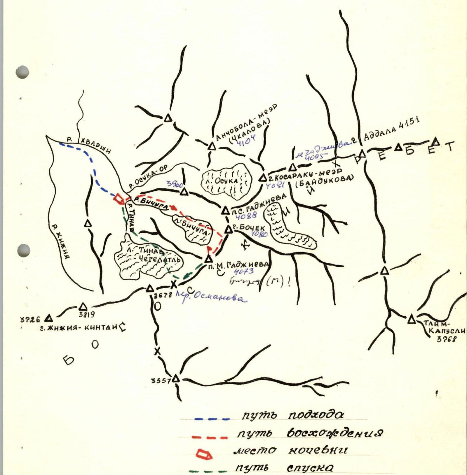
Approach to the Route Description
Approach to the route to the summit p. M. Gadjieva. Approximately 3A category of difficulty.
From the village of Khanokh in the Tsumadinsky district, move along the right bank of the Khvarshi river in the direction of the farm (0.5 hours). Before reaching the farm, cross the Khvarshi river over a small bridge (a place for a base camp) and move up to the right along a trail that goes along a steep talus slope. From here, follow a clearly visible trail to the confluence of the Bichuga and Tinav rivers, where there are good areas for an overnight stay near the "green cliffs" (2–2.5 hours from the farm).
Route Description
Route to the summit p. M. Gadjieva. Approximately 3A category of difficulty.
From the overnight stay at the confluence of the Bichuga and Tinav rivers, cross the Bichuga river and move up along the talus slope, bypassing the Bichuga glacier on the left. At the point where the glacier flattens, move to its middle under the steep ice-snow ascent (1 hour) — this is the start of the route. From here, ascend the steep ice-snow slope upwards in the direction of a clearly visible saddle (3.5–4 hours).
From the saddle:
- to the right towards a rocky outcrop on the ice-snow ridge (0.5 hours) — a control cairn is located here.
From the control cairn:
- Along the ice-snow ridge (cornice) and easy rocks, reach the summit of p. M. Gadjieva (1.5–2 hours).
Descent:
- Along the ridge in the direction of the Tinav - Chegelatl pass.
- Further to the overnight stay location (via the 1B category route).
Characteristics of Route Sections
To the summit p. M. Gadjieva from the glacier along the northern ridge. Approximately 3A category of difficulty.
 www.alpfederation.ru↗
 www.alpfederation.ru↗
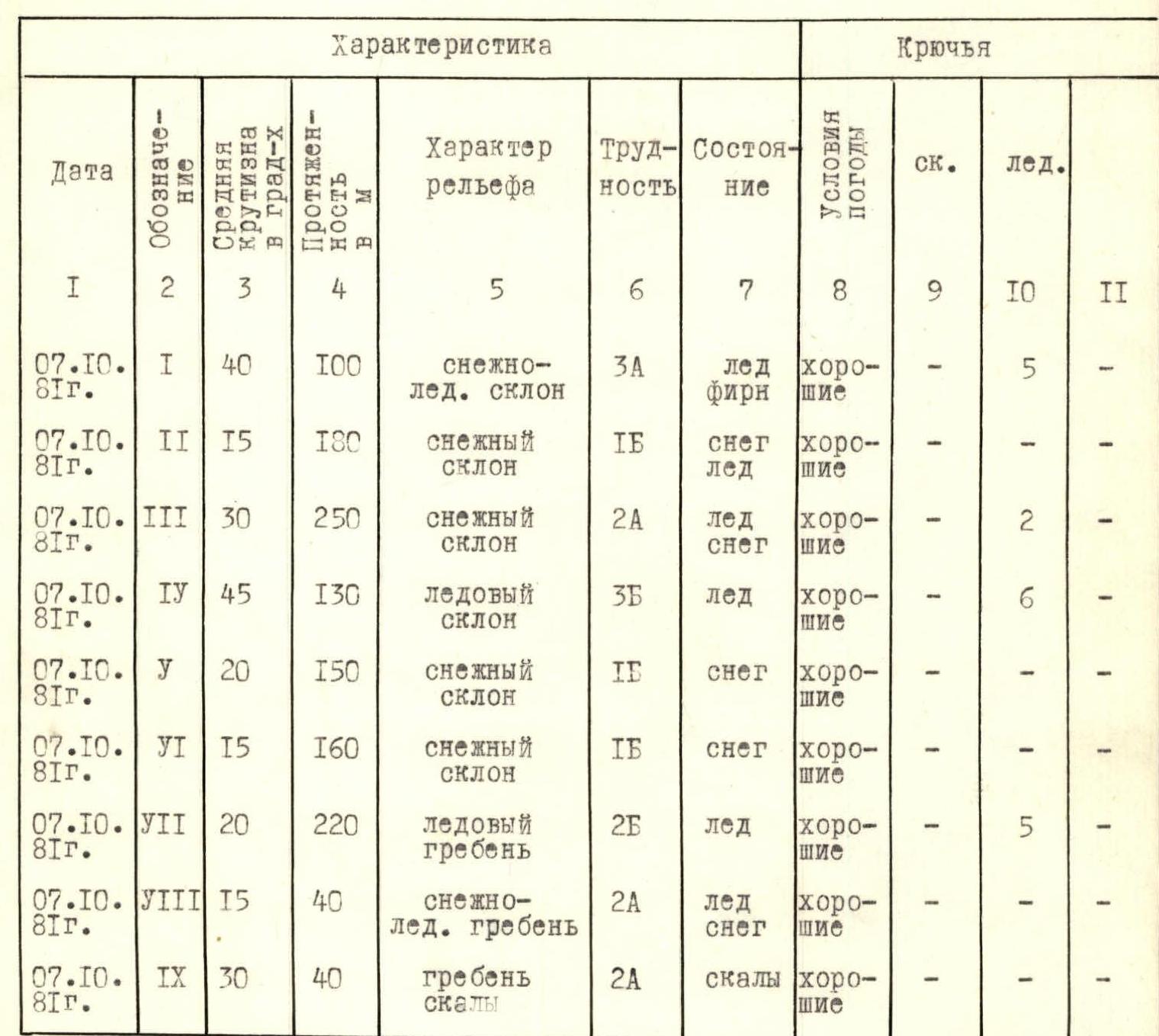
| Date | Designation | Average steepness in degrees | Length in meters | Terrain characteristics | Difficulty | Condition | Weather conditions | Rock anchors | Ice anchors |
|---|---|---|---|---|---|---|---|---|---|
| 07.10.1981 | R1 | 40° | 100 | snow-ice slope | 3 | ice, firn | good | – | 5 |
| 07.10.1981 | R2 | 15° | 180 | snow slope | 1 | snow, ice | good | – | – |
| 07.10.1981 | R3 | 30° | 250 | snow slope | 2 | ice, snow | good | – | 2 |
| 07.10.1981 | R4 | 45° | 130 | ice slope | 3 | ice | good | – | 6 |
| 07.10.1981 | R5 | 20° | 150 | snow slope | 1 | snow | good | – | – |
| 07.10.1981 | R6 | 15° | 160 | snow slope | 1 | snow | good | – | – |
| 07.10.1981 | R7 | 20° | 220 | ice ridge | 2 | ice | good | – | 5 |
| 07.10.1981 | R8 | 15° | 40 | snow-ice ridge | 2 | ice, snow | good | – | – |
| 07.10.1981 | R9 | 30° | 40 | rocky ridge | 2 | rocks | good | – | – |
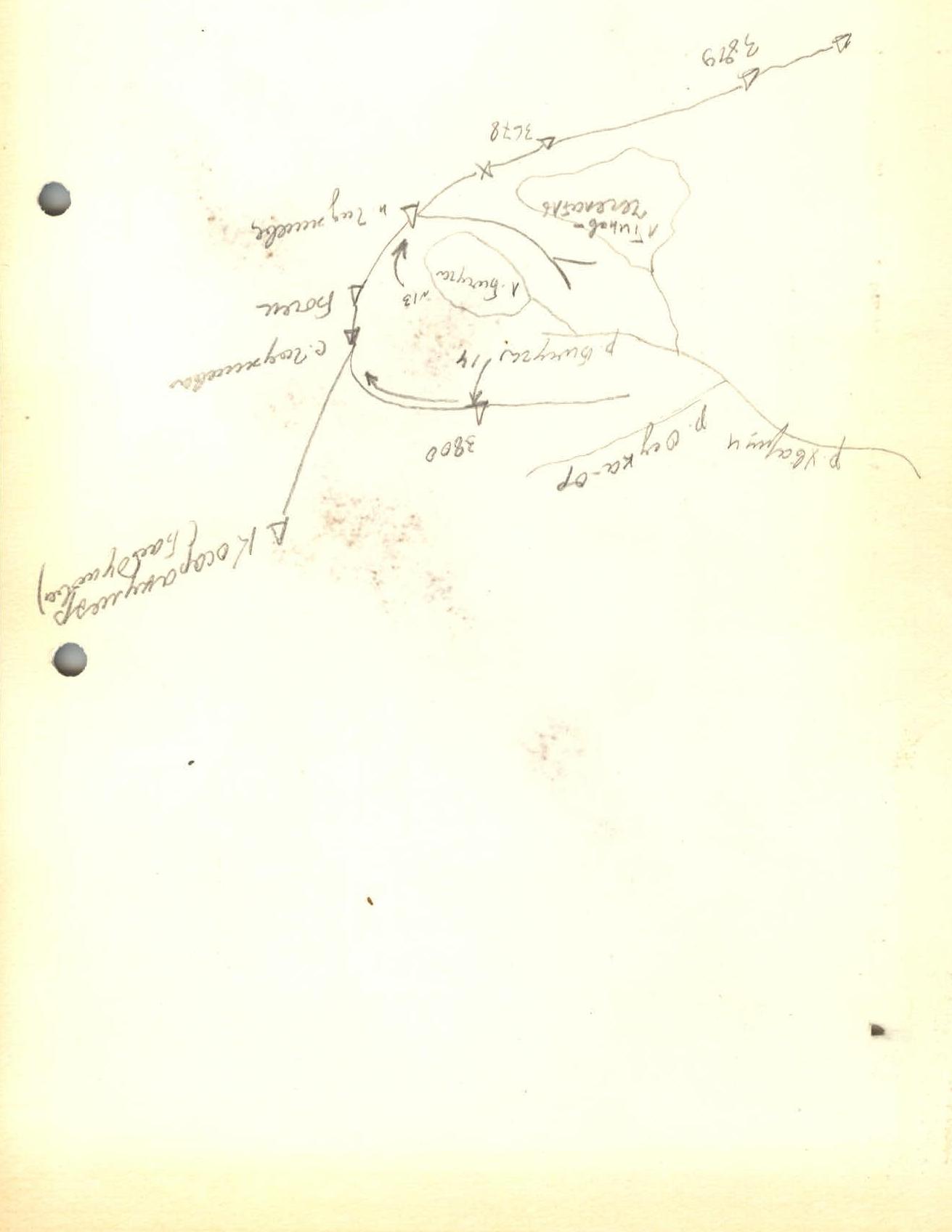
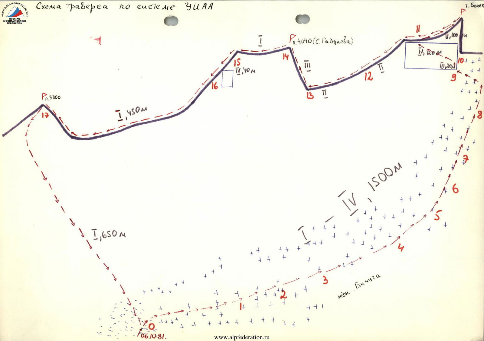
ZIAA Route Diagram
- approach path
- ascent path
- overnight stay location
- descent path