Ascent Passport
- Ascent Area
- Ascent Class
- Peak, its Height
- Ascent Route
- Estimated Difficulty Category
- Route Characteristics
- Pitons
- Number of Travel Hours
- Overnight Stay
- Surname I. O. of the Leader and Participants, their Sports Qualification
- Date of Ascent
- Team Coach
2.9.b. mountains of Dagestan Combined peak Chimismeer (p. M. Gadzhiev) 4099 m along the 10th ridge 1B Height difference — 500 m, average steepness — 25°, length of sections 1st cat. diff. – 800 m, 2 – 150 m. Not used 7 In the base camp
-
Gadzhiev K. I., MS
-
Sayapin A. K., 3rd sports category
-
Krasnopolsky Yu. V., 3rd sports category
-
Krasnopolsky V. V., 3rd sports category
-
Kasumov I. K., 3rd sports category
-
Pogozhev G., 3rd sports category June 5, 1967 MS Gadzhiev K. I.
-
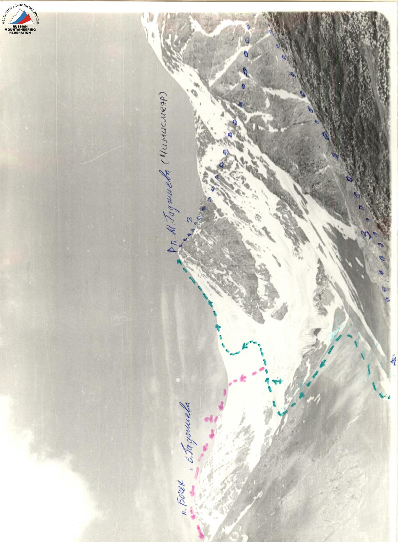
peak M. Gadzhiev from the Bichuga glacier (2B)
-
peak M. Gadzhiev — 3912 (traverse), 2B
-
peak M. Gadzhiev along the 10th ridge, 1B
-
Base camp
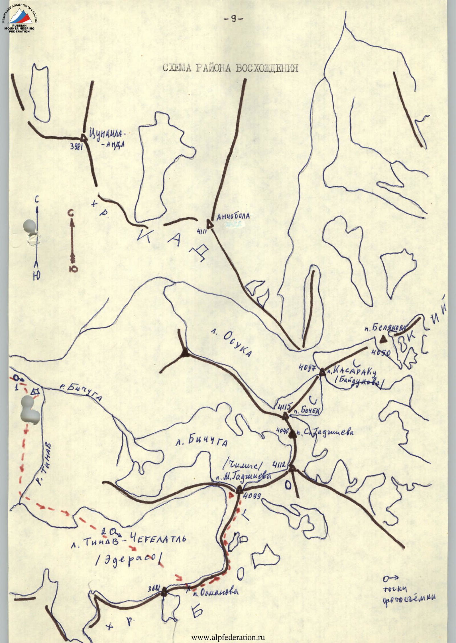
Brief Characteristics of the Peak peak M. Gadzhiev (Chimis) — the first (from S to NE) four-thousander of the Bogossky ridge. Actually, it is where the central — the highest uplift of this ridge begins, ending with the peak Izhen. To the S and N from peak M. Gadzhiev, ridges of the Bogossky watershed extend; to the W, a small spur separates the Bichuga glacier from the Tinav–Chegelatль (Ederaso) glacier. To the E and S, the massif of peak M. Gadzhiev is cut off by a slate wall with steep counterforts. The mountain is composed of aspidic slates with outcrops of hard crystalline sandstone.
Due to the significant area of glaciation, the region is characterized by unstable weather. In summer, there are almost daily strong thunderstorms. In spring — snowfalls. The best time for ascents is mid-August – early October.
Climbers have ascended peak M. Gadzhiev repeatedly. The first ascenders suggested naming this peak in memory of the Hero of the Soviet Union, submariner Magomed Gadzhiev. The name Chimis is found on diagrams and photographs in G. Merzbacher's book "Caucasus", vol. 2, – 1901.
A classified route to peak M. Gadzhiev has been laid from the Bichuga glacier (2B); a route from the Tinav–Chegelatль glacier and along the 3rd ridge (2A) has been traversed but not classified.
Description of the Approach to the Base Camp:
From the village of Agvali — the administrative center of the TsUMADINSKY district of the Dagestan ASSR — to the village of Khonokh, about 50 km by road. Then go along the trail into the left (in the direction of travel) gorge. Not reaching the MTF (1 km from Khonokh), cross the river by a bridge or ford and move along the right slope past the summer pastures to the clearing at the confluence of the Bichuga and Tinav rivers (from Khonokh 2.5–3 hours). Here, in the clearing at the "Green Rocks" — good sites for a bivouac.
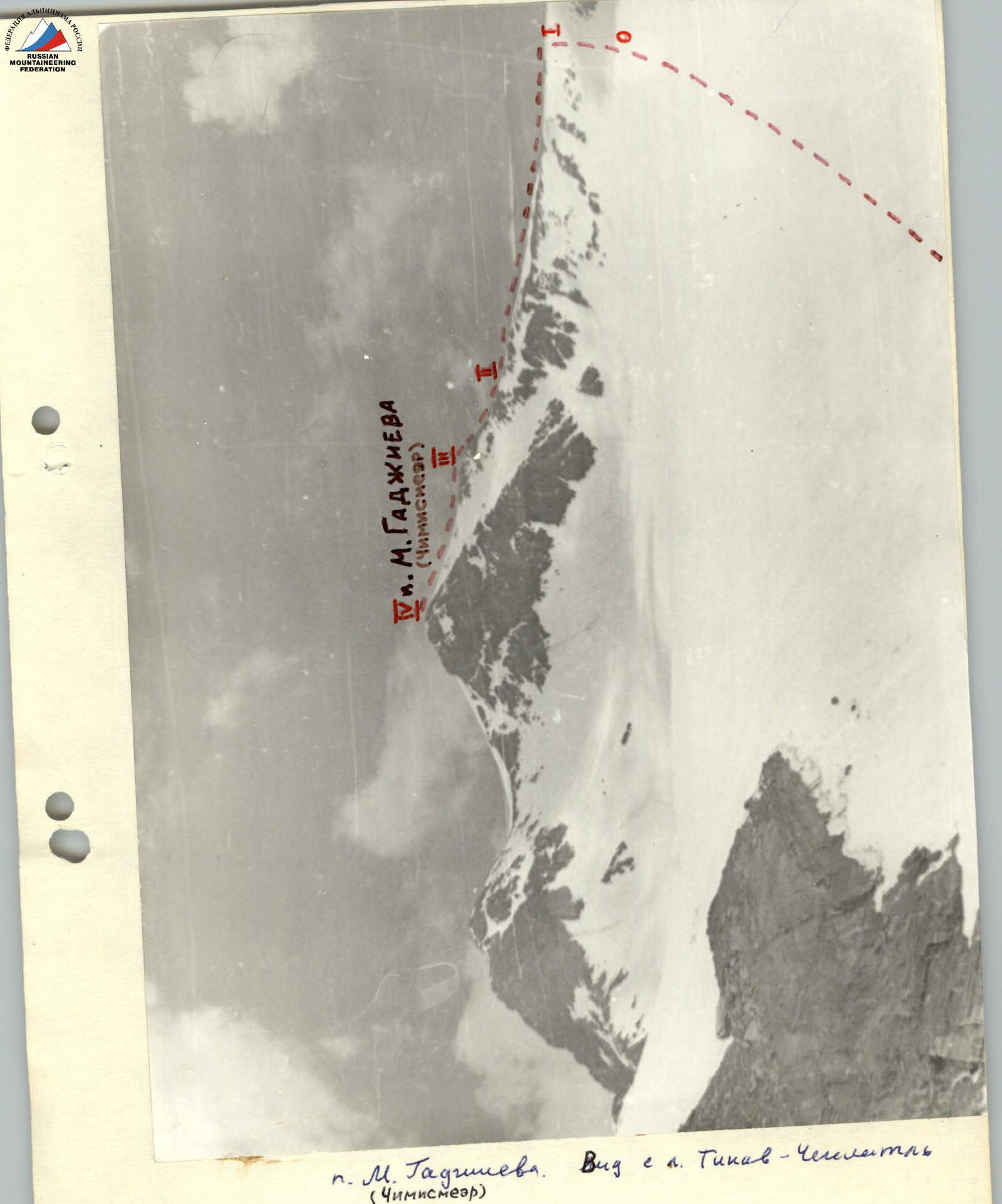
Peak M. Gadzhiev. View from the Tinav–Chegelatль (Chimismeer) glacier.
Description of the Approach to the Route:
From the overnight stay at the confluence of the Bichuga and Tinav rivers, go to the right along the bank of the Tinav river to the place where it emerges from under the left branch of the Tinav–Chegelatль glacier. Here, ford the river and ascend to the glacier, cross it in a westerly direction to the pronounced leftmost pass saddle (pass M. Osmanova). The glacier abounds in closed crevices — go in rope teams. From the camp to the pass 2–3 hours.
Description of the Route:
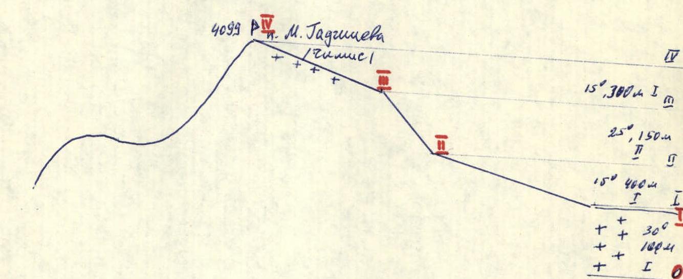
Along a gentle snowy slope to the left of the pass saddle, reach the 10th ridge of peak M. Gadzhiev and first along the talus, then along the destroyed slate rocks and again along the talus, proceed to the summit. From the pass 1.5–2 hours. Along the entire length of the ridge, go with belay, as it drops off to the W with a sheer wall. At the summit — a cairn and a memorial plaque. Descent along the ascent route (to the camp 1.5–2 hours).
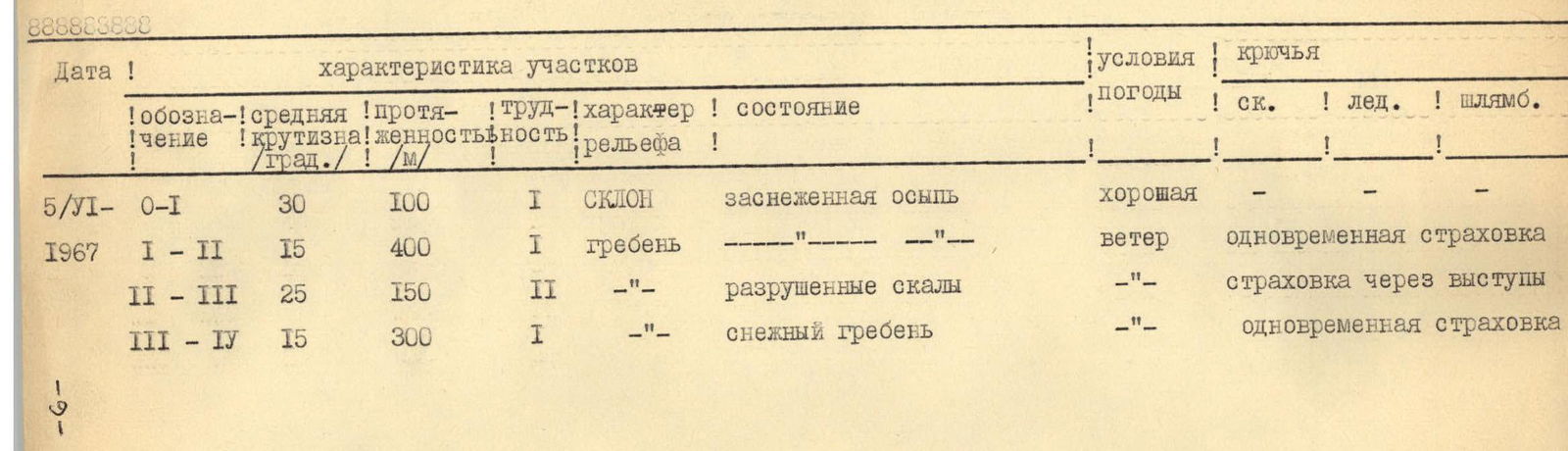
TABLE OF ROUTE SECTIONS
| Date | Designation | Average Steepness /deg./ | Length /m/ | Difficulty | Relief Character | Condition | Weather Conditions | Pitons | ||
|---|---|---|---|---|---|---|---|---|---|---|
| Rock | Ice | Sl. | ||||||||
| 5/VI | O–I | 30° | 100 m | 1 | Slope | Snow-covered talus | Good | — | — | — |
| 1967 | I–II | 15° | 400 m | 1 | Ridge | «—» | Wind | Simultaneous belay | — | — |
| II–III | 25° | 150 m | 2 | «—» | Destroyed rocks | «—» | Belay through outcrops | — | — | |
| III–IV | 15° | 300 m | 1 | «—» | Snow ridge | «—» | Simultaneous belay | — | — |
Route Diagram in UIAA Symbols