
Ascent Passport
- Winter ascent class.
- Caucasus, region 2.10., Dagestan Mountains.
- Tlimi-Mer 2456 m, from the south, rocky route.
- Category 2B complexity.
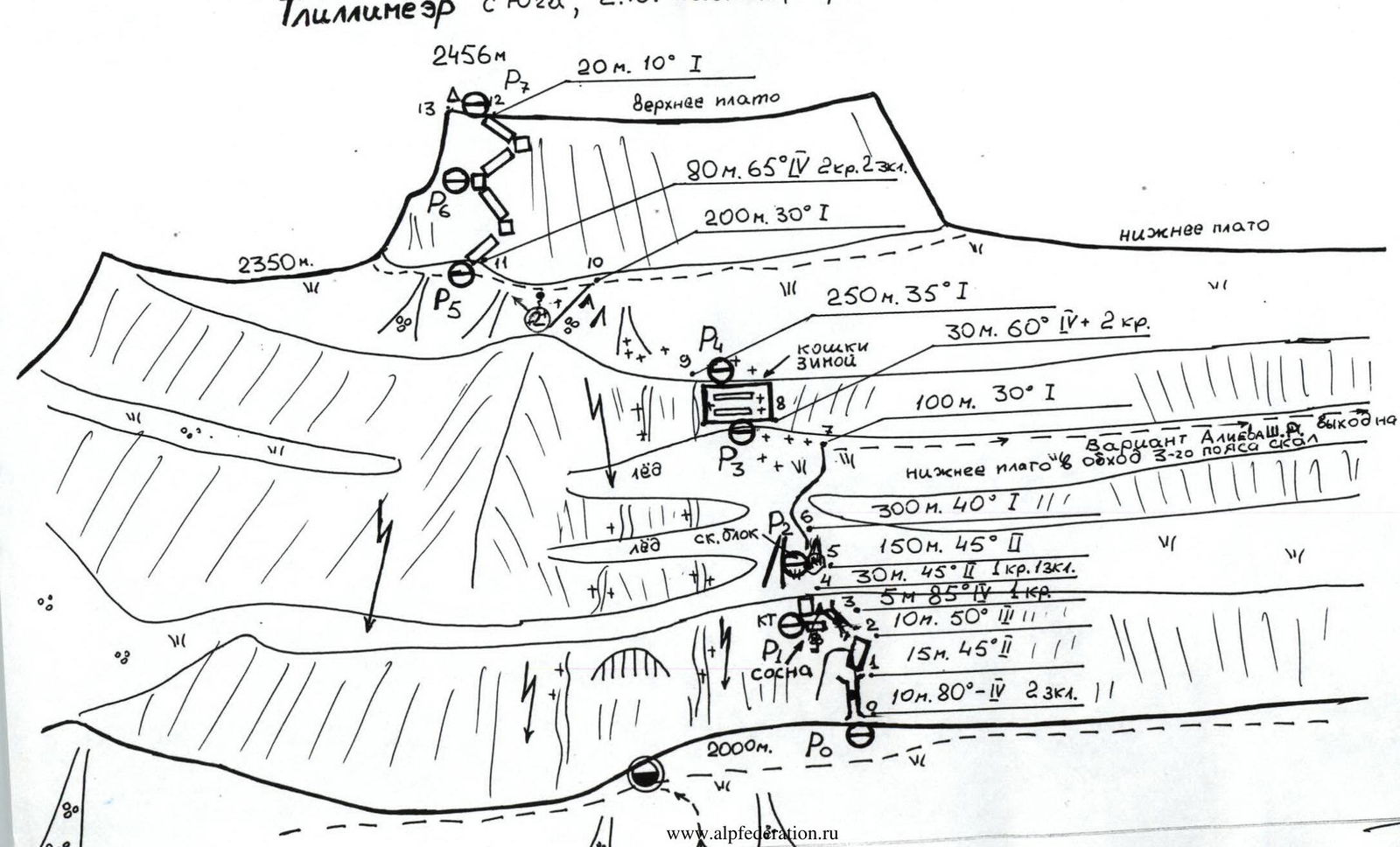
- Height difference 450 m, total route length — 1200 m, sections of 1st cat. diff. – 1020 m, 2nd cat. diff. – 45 m, 3rd cat. diff. – 10 m, 4th cat. diff. – 125 m, average steepness of the route 45°.
- Used: rock pitons – 6 pcs., chocks – 5 pcs.
- Moving hours – 4 hours.
- No overnight stays. Overnight stay under the lower rocky belt, under the cornice between two waterfalls (2000 m).
- Leader: Konstantin E. Dorro — Candidate Master of Sports
Team members:
- Sergey V. Voronin — 1st sports category
- Vladimir A. Sogokon — 1st sports category
- Shanavaa E. Shanavazov — Candidate Master of Sports
- Departure, summit, return — December 26, 1994.
- Organization: Eos Mountain Club and Dagestan Rescue Service of the Ministry of Emergency Situations of Russia.
Makhachkala. 1995.
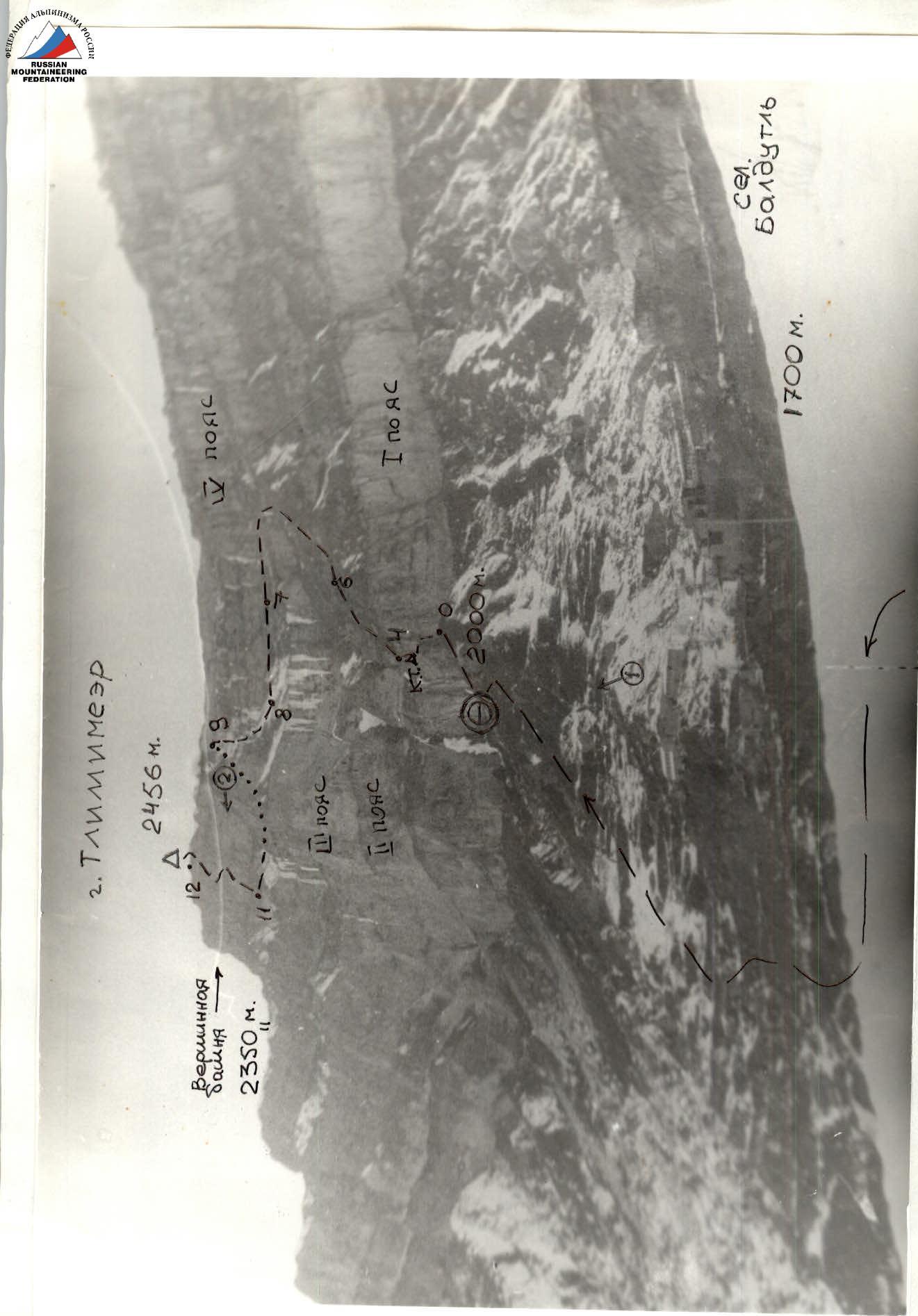
General view photo 2. Tlimi-Mer. Route 2B cat. diff. from the south. Photo taken on December 26, 1994. From 1650 m – surroundings of Baldutl village.
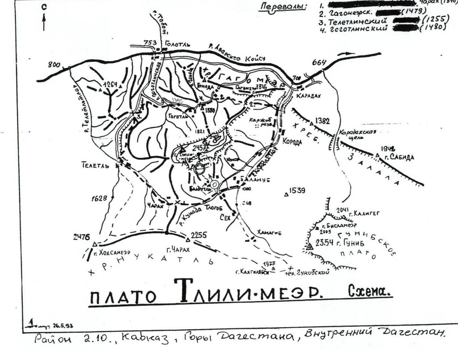
Region 2.10., Caucasus, Dagestan Mountains, Inner Dagestan. May 26, 1993. Tlimi-Mer plateau. Scheme. For K. Dorro. Ko.
Approach to the route description
Of Gunibsky
From Karadakh village (740 m) in Shamilsky district of the Republic of Dagestan, up the right tributary of the Avar Koisu river — Karadakh-Tlar river, through Koroda village along a dirt road to Baldutl village (1700 m). Then along scree and grassy ridges move north under the southern wall of Tlimi-Mer. Overnight stay here, under a characteristic overhang between two waterfalls. Attention! Further:
- 5 m from the wall, a site is broken by stones and ice.
- To the start of the route — along the trail to the right (east) about 100 m (2000 m, 1 hour from Baldutl village).
- Behind the corner of the rocky block at the top of the scree cape — beginning of the route.
The summit is composed of limestone, partially metamorphosed. Relief is well-defined. The walls completely encircle the summit. The summit is revered by locals. The most challenging routes have not been climbed yet, for example:
- along the center of the NE wall — 5th cat. diff.

Photo 1. Lower part of the route. Sections R0–R6. Photo taken from the approach, from 1900 m. December 26, 1994.
Route description
Start of the route: a characteristic chimney with a plug, to the right of the rocky block cape, protruding from the lower rocky belt of the southern wall (R0–R1). Onto a grassy inclined shelf (slippery in snow!) and then approach the block, and behind it — into the cleft. Pass under the plug to the left onto a shelf (R1–R3), here R1. A pine tree grows here, a control cairn is tied to it. Move slightly left, and along an unpleasant wall (R3–R4) exit onto a steep grassy slope (R4–R5). R2 is organized on the rocky block-cape. Further along a steep grassy couloir left of the block and then, moving right onto a vaguely defined ridge with rock outcrops (R6–R7), here the second and third rocky belts fade away. Approach the fourth belt and move left about 100 m to the lowest point in the fourth rocky belt: a series of walls and shelves, in winter — built-up ice (crampons, ice screws), steep sections (R8–R9). Exit onto a terrace and slightly left along the ridge and large-block scree — under the summit tower («saddle») (there is water: a spring), then traverse left under the wall and, about 100 m before the saddle, begin ascent to the summit tower (R11–R12), here the wall is the least steep, oblique shelves alternate with walls, relief is reliable. Exit directly onto the summit (2456 m), cairn — this is the western part of the «saddle».
On the summit plateau:
- there is a hut;
- the summit is visited by locals for ritual purposes;
- be cautious! On the plateau, crevices (of tectonic or karst origin) in tall grass or snow are hazardous.
Descent:
- by the ascent route;
- or after descending from the summit tower, move right onto the saddle (2350 m);
- from it, descend NW, keeping to the right of the rocks, and then moving left along the path;
- from the west, bypass the Tlimi-Mer rock massif and along the wall exit to the overnight stay site (about 2 hours).
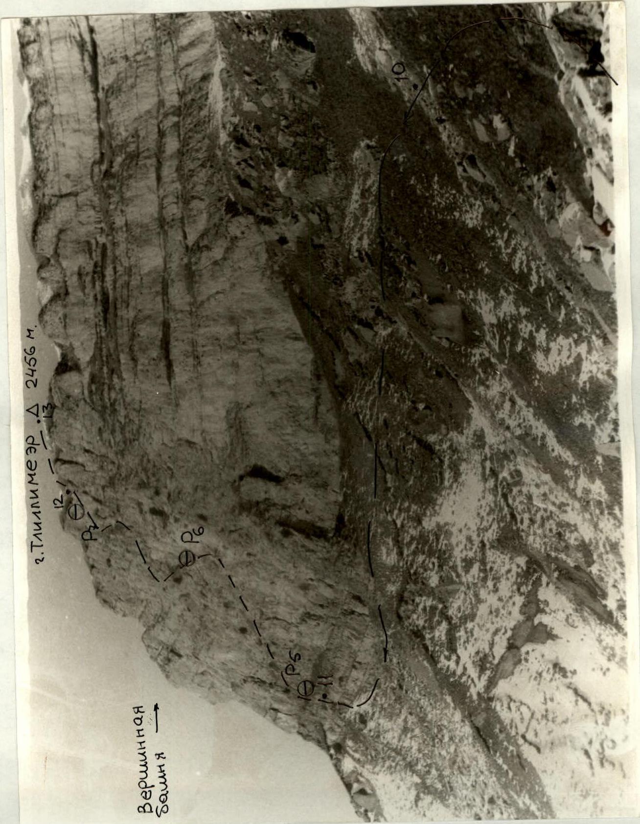
Photo 2: Summit tower (rocky belt). Sections R10–R13. Photo taken from the upper terrace. December 26, 1994.
Tlimi-Mer from the south, 2.10. Caucasus, Dagestan Mountains. 2B cat. diff.
Comments
Sign in to leave a comment