
605646
ASCENT REPORT
- ASCENT CLASS: Rock climbing
- ASCENT AREA, MOUNTAIN RANGE: 2.10 (2B) Dagestan Mountains, Eastern Caucasus
- PEAK, ITS HEIGHT, ASCENT ROUTE: Mt. Sel'dy 3664 m via the diagonal crack on the Southwest wall, rock climbing.
- PROPOSED DIFFICULTY CATEGORY: 4A
- ROUTE CHARACTERISTICS: Height difference — 360 m; length of sections with 4–5 difficulty category — 270 m; average steepness of the route — 55°; wall section steepness — 59°.
- PITONS PLACED:
- Chocks — 53/2
- Rock pitons — 31/2
- Ice screws — 0/0
- Bolts — 0/0
- DURATION OF CLIMBING: 9 hours
- NUMBER OF NIGHTS SPENT AND THEIR CHARACTERISTICS: No overnight stays.
- SURNAME, NAME, PATRONYMIC OF THE LEADER, PARTICIPANTS, AND THEIR QUALIFICATION:
- VELIKANOV VLADIMIR YUR'EVICH — 1st sports category
- SMOTROV SERGEY IVANOVICH — Candidate for Master of Sports
- TEAM COACH: SMOTROV S.I., Candidate for Master of Sports
- DATE OF DEPARTURE AND RETURN: December 1, 1989, 5:00 AM — departure from base camp; December 1, 1989, 6:00 PM — return.
- ORGANIZATION: SNPP "Energoinformatika", Erydag tourist base
The route was first ascended in November 1984 by a group of the same composition, but unfortunately, a report was not compiled. Repeated on December 1, 1985. Kotov, Smotrov, and Velikanov worked at the Erydag tourist base.
Work Schedule
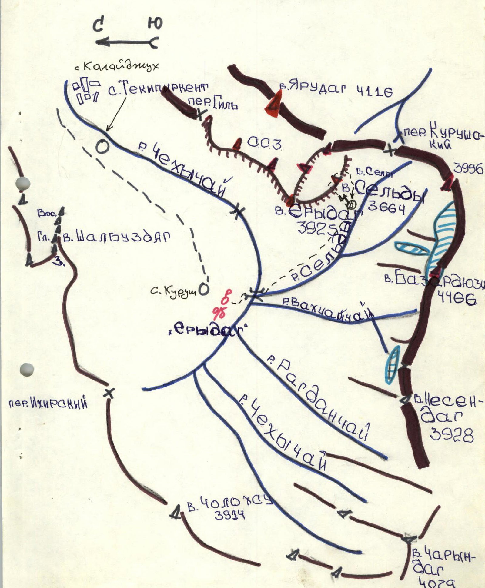
Other Routes in the Area
- Team's route: via the diagonal crack on the SW wall — 4A
- Via the 3rd wall: 3B category, A. Peresada, 79 (2.10.48)
- Via the 10.3 couloir: 2A category, P. Leonov, 89 (2.10.47)
- Via the SW buttress: 3B category, V. Melnikov, 79 (2.10.49)
- Via the 10th wall: 4B category, E. Rushh, 81 (2.10.51)
ROUTE DIAGRAM IN UIAA SYMBOLS
Mt. Sel'dy 3664 m.
- R13–R14: 40 m, 65°, IV, plateau
- R12–R13: 30 m, 70°, IV+
- R11–R12: 80 m, 60°, IV
- R10–R11: 80 m, 60°, IV
- R9–R10: 20 m, 70°, V
- R8–R9: 20 m, 60°, IV+
- R7–R8: 30 m, 80°, V+
- R6–R7: 15 m, 60°, IV+
- R5–R6: 35 m, 45°, IV+
- R4–R5: 15 m, 40°, II+
- R3–R4: 15 m, 50°, III+
- R2–R3: 30 m, 30°, I
- R1–R2: 40 m, 45°, II
- R0–R1: 120 m, 30°, I
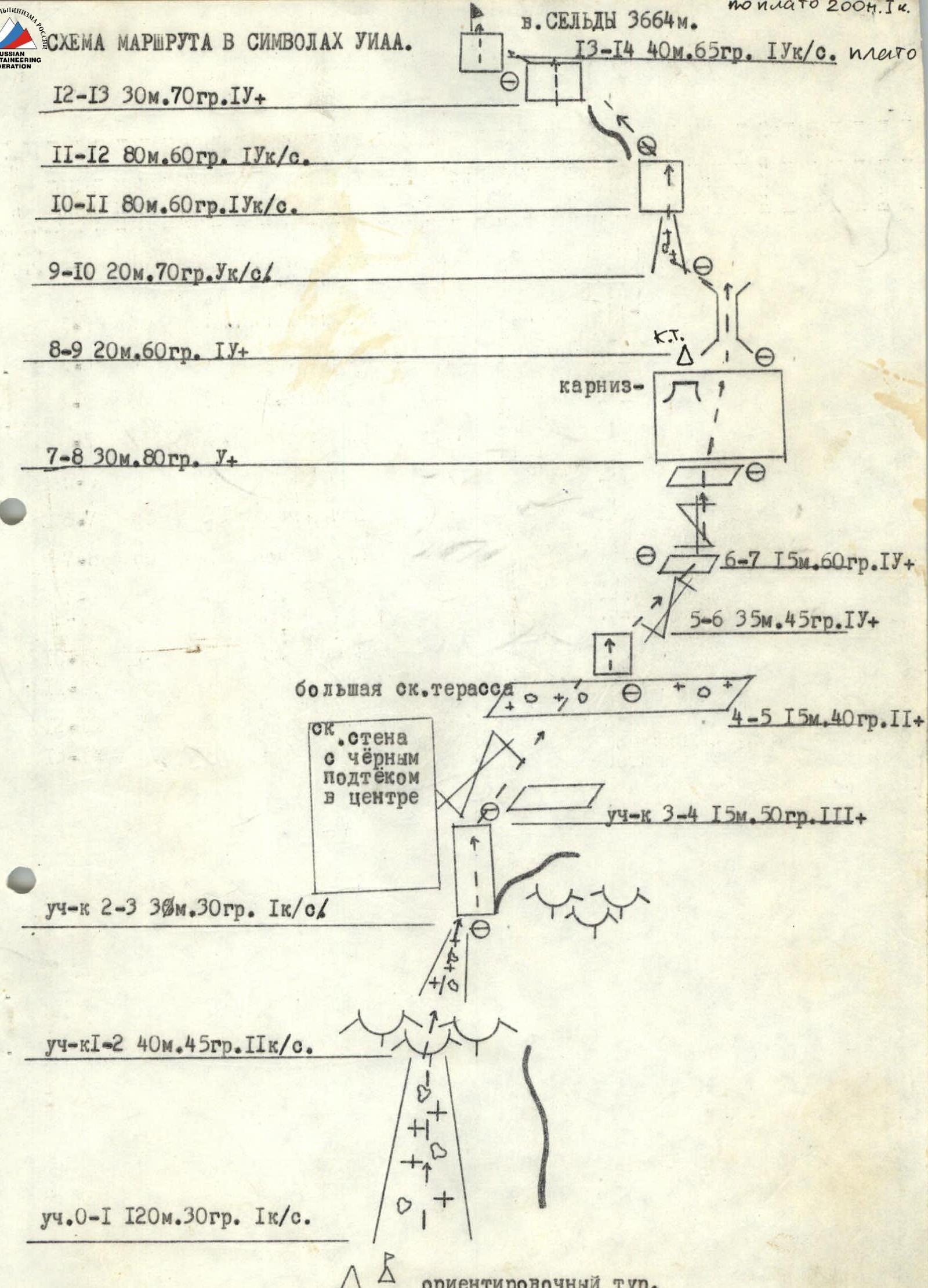
BRIEF DESCRIPTION AND EXPLANATION OF THE TABLE
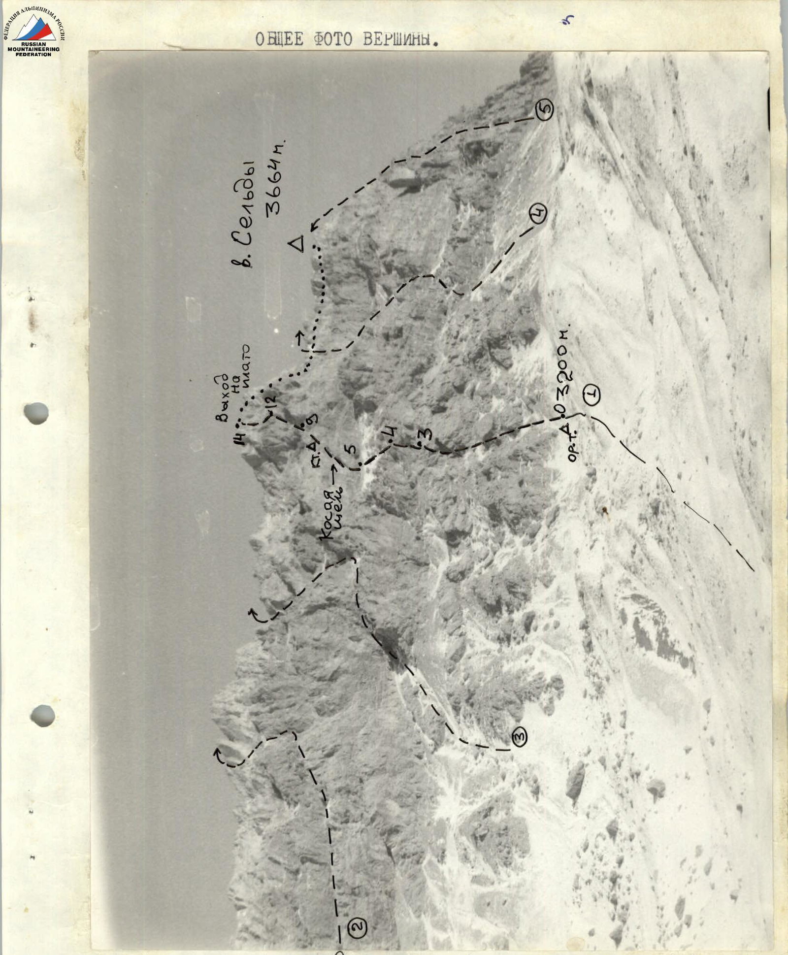
From the Erydag base through the bridge over the Chekhy-chay river and further along the trail towards Mt. Sel'dy to the start of the route, where there is a landmark cairn. From the base 2–2.5 hours. Up a steep scree couloir slightly to the right, past a large rock wall with a black streak in the center, to the "ram's foreheads." Via the "ram's foreheads" (easy climbing) — exit into a scree couloir, then through a small rock wall and a system of "ram's foreheads" — exit onto a large scree terrace (1–1.5 hours from the start of the route).
From the terrace, move up and to the right via a diagonal crack to a convenient ledge for belaying — exit onto a small shelf under a steep rock wall with an overhanging eave on the left. This is the key section of the route: up the wall to the left of the eave — exit under the base of a chimney, climbing is more difficult, possibly using p. 1.0. After the chimney, via a snowy couloir — exit under the wall, through a system of rock walls above the average difficulty straight up — exit onto Mt. Sel'dy. 7–8 hours from the start of the route.
The route is logical and practically free of rockfall hazards. The southwest exposure makes it quite warm during the cold season.
The rock sections of the route are monolithic with a sufficient number of cracks and holds, which allows for the wide use of rock pitons and chocks. The variety of rock formations requires a wide application of rock climbing techniques, making the route interesting to climb. However, the difficulty of the route is identical to the route on Mt. Sel'dy via the South wall, 4B category, by E. Rum 1981.
Descent from the summit via the 1B category route.

TABLE OF MAIN ROUTE CHARACTERISTICS. ASCENT.
(Data as of December 1, 1989)
| Section | Average steepness | Length | Relief characteristics | Difficulty (UIAA) | Condition | Weather conditions | Chocks | Rock pitons | Ice screws | Bolts |
|---|---|---|---|---|---|---|---|---|---|---|
| R0–R1 | 30° | 120 m | Steep scree couloir | I | Snow-covered | Sun, frosty wind | 0 | 0 | 0 | 0 |
| R1–R2 | 45° | 40 m | "Ram's foreheads" | II | Iced | –!!– | 0 | 0 | 0 | 0 |
| R2–R3 | 30° | 30 m | Steep scree couloir | I | Snow-covered | –!– | 0 | 0 | 0 | 0 |
| R3–R4 | 50° | 15 m | Rock wall | III+ | Icy rocks | –!– | 2 | 3 | 0 | 0 |
| R4–R5 | 40° | 15 m | "Ram's foreheads" | II+ | Iced | –!– | 2 | 2 | 0 | 0 |
| R5–R6 | 15° | 20 m | Rock terrace | I | Snow-covered | –!– | 0 | 0 | 0 | 0 |
| R6–R7 | 45° | 35 m | Diagonal crack | IV+ | Partially iced | –!– | 4 | 6 | 0 | 0 |
| R7–R8 | 30° | 15 m | Diagonal crack | IV+ | Partially iced | –!– | 2 | 3 | 0 | 0 |
| R8–R9 | 80° | 30 m | Rock wall | V+ | Good | –!– | 4 | 6 | 0 | 0 |
| R9–R10 | 60° | 20 m | Chimney | V+ | Iced | –!– | 2 | 4 | 0 | 0 |
| R10–R11 | 70° | 20 m | Rock wall | V | Good | –!– | 2 | 5 | 0 | 0 |
| R11–R12 | 60° | 80 m | Steep rock ridge | IV | Dry | –!– | 0 | 10 | 0 | 0 |
| R12–R13 | 70° | 30 m | Rock wall | IV+ | Good | –!– | 4 | 6 | 0 | 0 |
| R13–R14 | 65° | 40 m | Rock wall | IV | Good | Frosty wind | 3 | 8 | 0 | 0 |
Comments
Sign in to leave a comment