ASCENSION AREA — CHARODINSKY, EAST CAUCASUS, DASSR
The summit METIKO 3814 m
via the north face, category 2B
Climbing team members:
- Leader: Timoshin Mikhail Egorovich Master of Sports of the USSR
- Pashuk Evgeny Grigorievich III category
- Kozarezov Evgeny Fedorovich —"—"—
- Leonov Petr Georgievich —"—"—
- Yakhyaev Ruslan Krimsultanov —"—"—
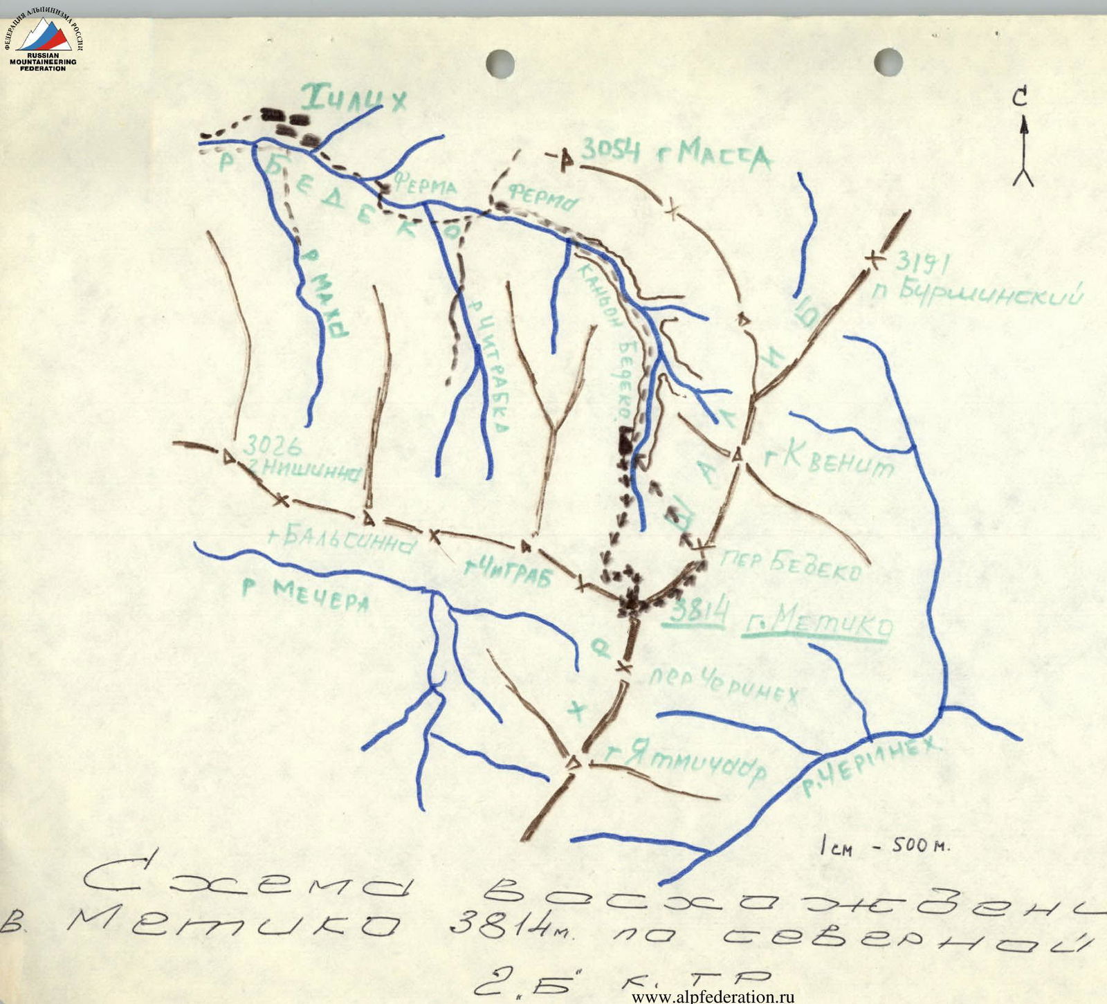
The summit Metiko is located in the Shalibsky ridge. It is one of the many ridges forming the intricate mountain country of the Charodinsky area, uniting the upper reaches of the Kara-Koisu, Kazikumukhskoe Koisu, and Samur rivers. This mountain massif is connected by a low ridge to the Main Caucasian Range in the area of Mt. Guton.
The base camp for ascending the wall, as well as for ascending via the N-3 ridge (category 1B), is set up in the upper reaches of the Bediko river. It takes 3 hours to get here from the village of Archib, first along a good trail to the farm, and then along the bottom of a deep rocky gorge (mudflow!), bypassing numerous 5-8 m waterfalls on simple rocks.
From the overnight stay on the grassy site in the upper reaches of the Bediko river (2800 m), head right upwards, first along the grassy slopes of the Chitrab ridge, then through deep snow around the cirque of the ancient glacier, which is under the north face, in the direction of the saddle between Mt. Chitrab and Metiko. 100 m before reaching it, there is a snow site - here, tie in. It takes 2 hours from the overnight stay, elevation 3320 m.
Then, traverse the deep snowfield at the base of the wall (simultaneous belay!) to exit into a steep (60°) snow couloir and through it (alternate belay!) bypassing two rocky belts - exit to the third. It takes 1 hour to get here from the snow site, elevation 3450 m. Exit under the rocky belt 40 m to the left of the couloir axis. From here, 6 m of moderately difficult rocks (a large number of holds filled with soft snow) lead to a good ledge. Here, organize piton belay and through difficult monolithic rocks 40 m (4 pitons. Holds are snow-covered, partially icy) - exit to a steep 70° snow belt. The wall passage takes 2 hours for a group of 5 people. From here, through deep snow (alternate belay!), one rope - exit under the rocky belt. 10 m of destroyed easy rocks are passed with belay through protrusions. Then 30 m of 60° snowfield (alternate belay!) under the 5th rocky belt, 15 m high (monolithic rocks of moderate difficulty, one piton!) and up a steep 70° snow slope (alternate belay!) to the left upwards 40 m - first under the shale rocks, and then along their edge, exit under the summit wall. Moving directly up the snowfield is not rational, since deep, fluffy snow lies on shale slabs. The summit wall is bypassed along a snow ledge (alternate belay through ice axes and protrusions) to the right - two ropes - with an exit to the northwest ridge. It takes 2 hours to get here from the 3rd rocky belt, elevation 3650 m. Then, to the right - bypass the summit tower along talus ledges, and ascend up a not-very-pronounced talus couloir, overcoming numerous rocky steps 2-3 m (belay through protrusions!) to a narrow, sharp rocky saddle, separating Mt. Metiko from the Shalib ridge. From here, 30 m of moderately difficult, destroyed rocks (belay through protrusions!) upwards along the edge of the summit tower lead to Mt. Metiko (3814 m). Here is a large cairn. It takes 1 hour to get here from the exit to the ridge. Descent to the rocky saddle and then to the southeast 20 m along shale ridges to the ridge of the Shalib ridge and along it to the northeast to the pass saddle. From here, down a steep snow couloir and then along the stream bed, which gives rise to the Bediko river, to the base camp. The descent takes 1.5 hours.
Recommendations for climbers:
- Group size 4-6 people.
- Initial bivouac - upper reaches of the Bediko river.
- Departure time from bivouac - 3 am.
- Equipment for 4 people: main rope 2×40 m; rock pitons 6-8; ice pitons 1; rock hammers 2; carabiners 6-8.
- Possible bivouac locations - on the shoulder of the N-3 ridge under the summit tower, on the summit, on the "N-E Metiko" pass.
Photo 1. North face of Mt. Metiko 3814.
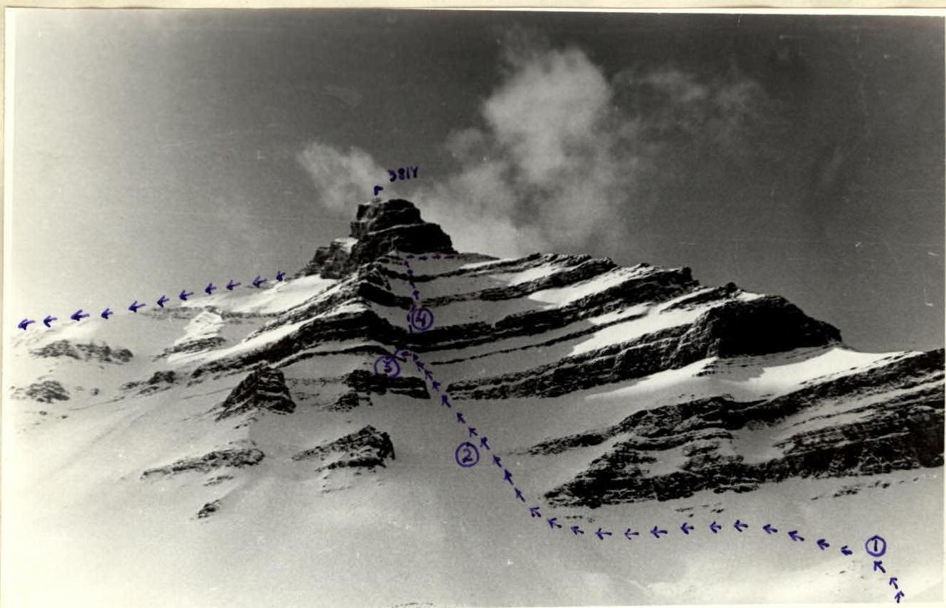
Ascent scheme to Mt. Metiko 3814 m via the north face, category 2B.