Russian Mountaineering Championship. First Ascent Category. Winter 2010
Report
on the first ascent by the Saint Petersburg team to Erydag (NW) 3877 m, via the inner corners of the right bastion on the NW wall.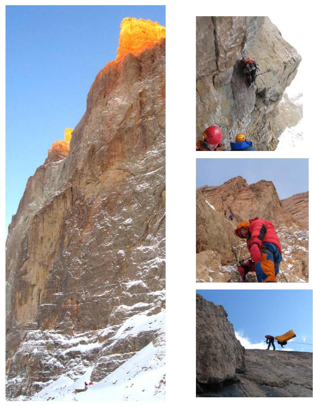
January–February 2010
Ascent Passport
-
Region 2.10, Caucasus, Dagestan Mountains, Chekhychay valley
-
Erydag (NW), 3887 m, via the inner corners of the right bastion on the NW wall
-
Complexity category: Proposed 6B category, first ascent
-
Route type: rock
-
Route elevation gain 1137 m, route length 3000 m. Wall section elevation gain 1000 m, wall section length (excluding traverse along ledges) 1200 m. Section lengths: 5th category 330 m; 6th category 650 m. Passed on artificial holds (AID) 882 m, complexity A1–217 m, A2–248 m, A3–407 m, A4–10 m. Average steepness: 1st bastion — 86 °; 1st and 2nd bastions — 79 °; wall section — 77 °.
-
"Hooks" left on the route: 1 anchor, 2 втулки от спитов.
Total "hooks" used on the route – 455, including:
- on the NW wall — 300
- on the right bastion — 100
- on the inner corners — 55
- removable bolts — 28 (15 for belay stations and 13 for progression),
- rock hooks (including топориков) — 117 (117 for belay / 115 for progression),
- chocks and camalots — 310 (203 for belay / 310 for progression).
Total artificial holds (AID) used – 612, including:
- removable bolts — 13,
- rock hooks (including топориков) — 115,
- chocks and camalots — 310,
- skyhooks (including progression on fiffs) — 174.
-
Team's total climbing hours: 95 hours, 11 days
-
Team leader: Oleg Koltsunov, Master of Sports Team members: Igor Viskov, Master of Sports Dmitry Krasnov, Master of Sports Ruslan Kirichenko, Master of Sports
-
Coaches: Tatiana Timoshenko, Alexander Dubovikov, Oleg Koltsunov.
-
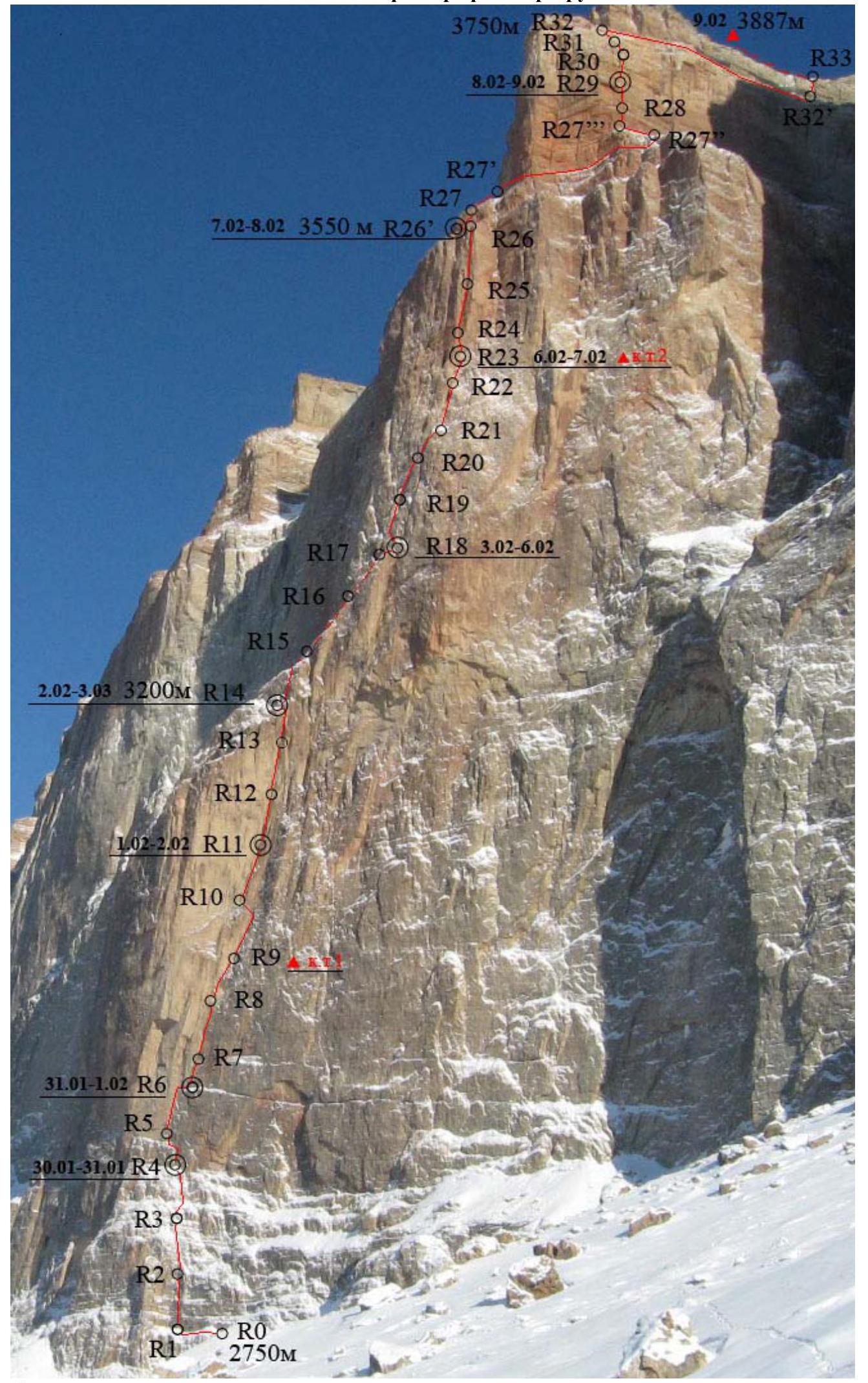
Departure to the route: 7:00, January 30, 2010.
Summit: 15:00, February 9, 2010. Return to Base Camp: 11:00, February 10, 2010.
General summit photo
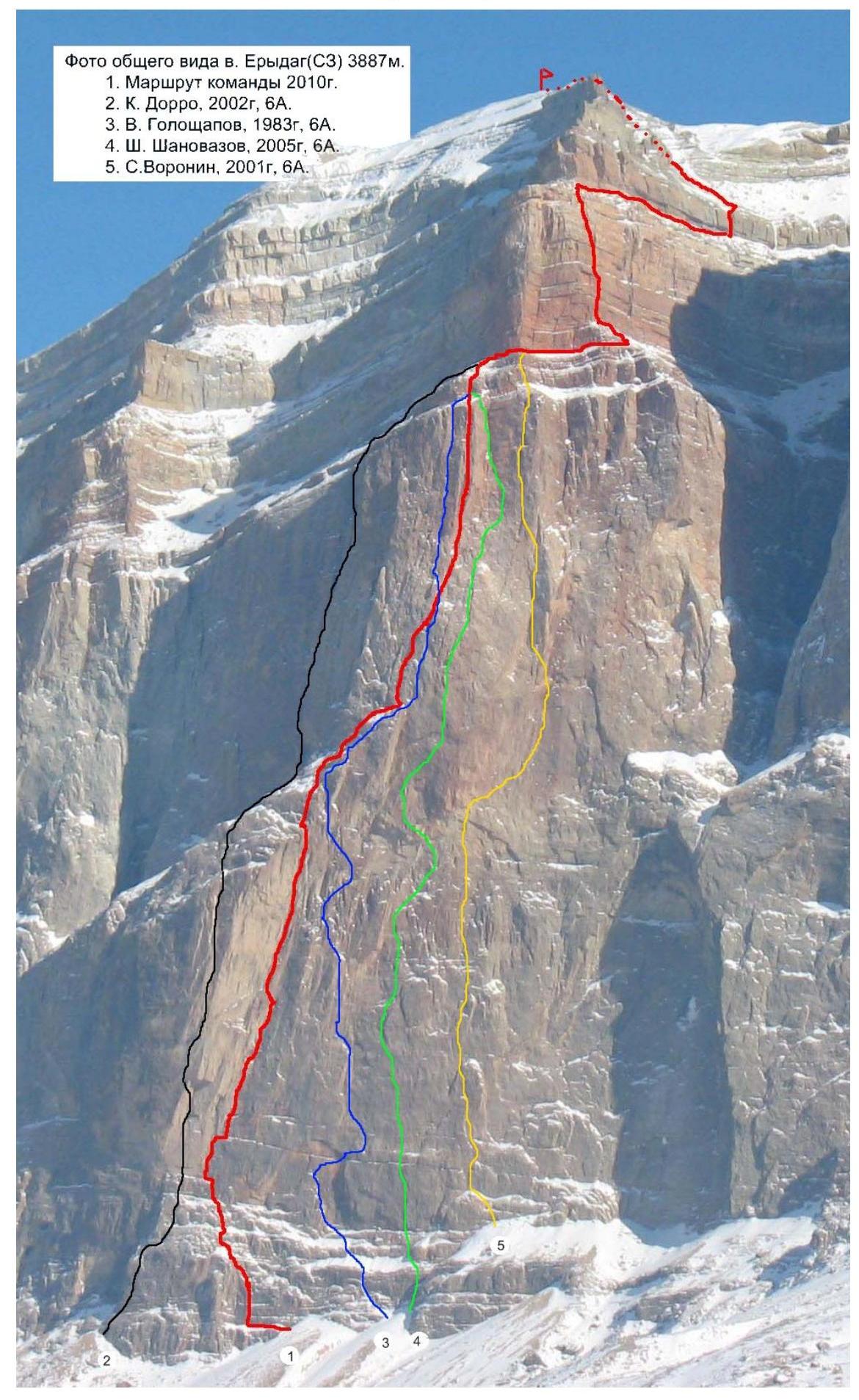
Photo of Erydag (NW) 3887 m.
- 2010 team route
- K. Dorro, 2002, 6A.
- V. Goloshchapov, 1983, 6A.
- Sh. Shanovasov, 2005, 6A.
- S. Voronin, 2001, 6A.
Taken on February 10, 2010, on the road before Kurush village.
Right profile photo of the route (2nd bastion)
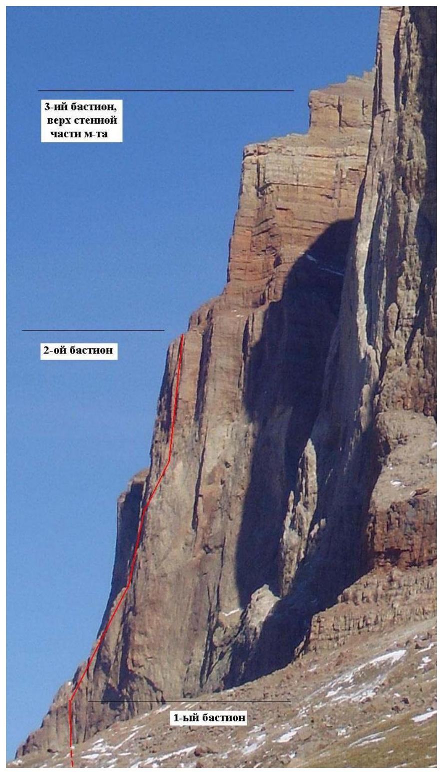
Photo taken in February 2007 on the approach to the base camp under the NW wall of Erydag (3925 m). The main thread of the route passes through two large inner corners of the first and second bastions. The "wall" of the inner corner of the first bastion does not allow for a photograph showing the profile of the route in this section. The third bastion is heavily destroyed, and the team's route here, like most routes on this bastion, follows the safest and most logical line proposed by E. Radoshkevich (route on the "right part of the NW wall", 1981).
Drawn profile of the route. Scale 1:5000

The steepness of the wall section of the first bastion is determined primarily by the system of overhanging corners forming a single large inner corner. The steep and average steepness of the corner is assessed as the average steepness of the two faces forming this corner. Thus, on the first bastion, the inclination of the right face varied between 80–95 °, and the left face between 85–120 °.
Area photopanorama
Brief description of the approach to the route
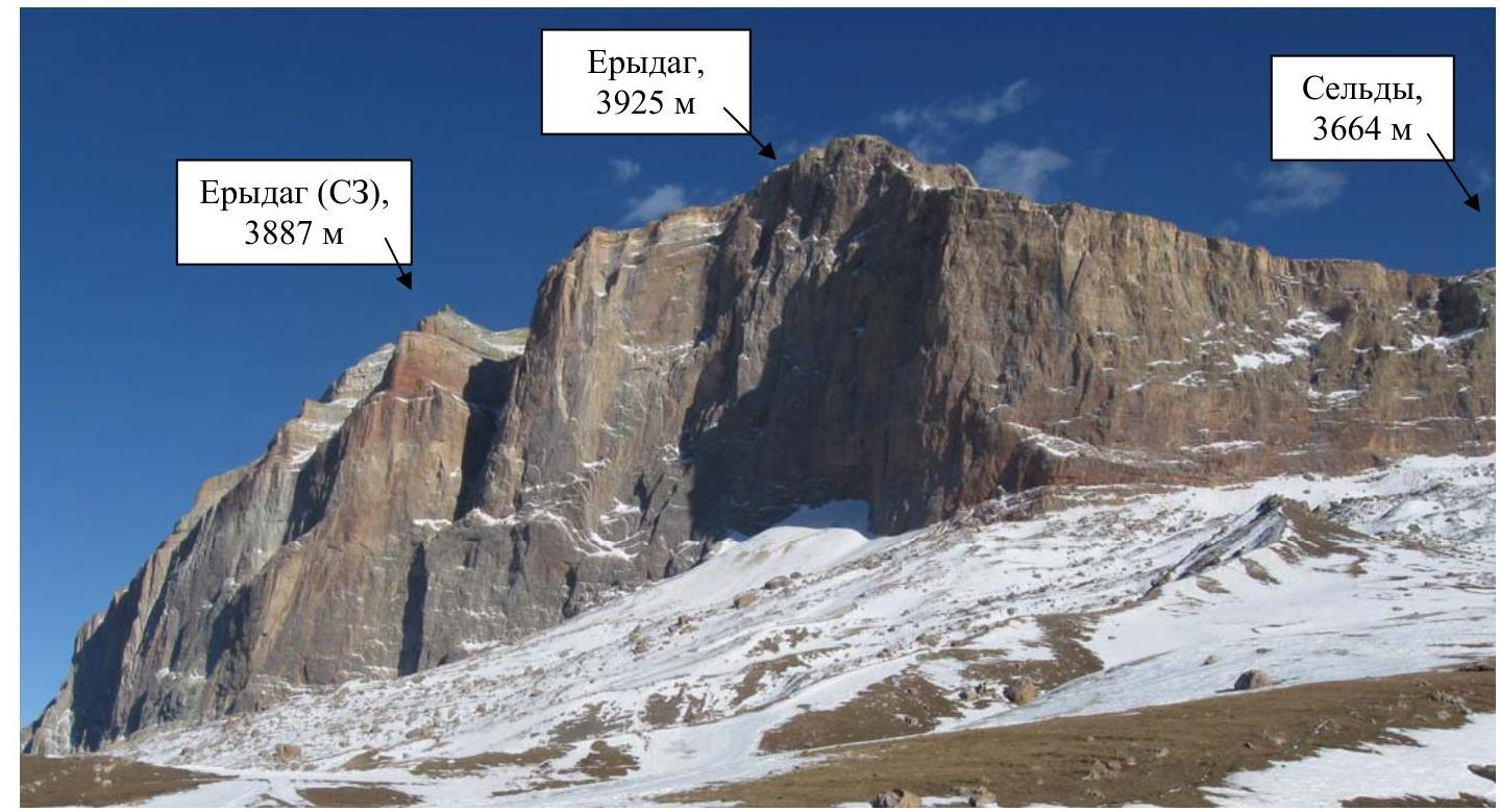
The Erydag massif is located in a short northeast spur of the Main Caucasian Range, on the border between Russia and Azerbaijan, and is a well-developed mountaineering object.
The advanced base camp (ABC) was set up in a location traditionally used as a starting point for ascending the NW wall to Erydag (3925 m). This is practically the only convenient and close location, situated on a gentle slope of a scree slope about 200 m from the wall (opposite the start of the Shchedrin route).
The travel time from the farm to the ABC is about 3 hours (depending on the amount of snow and the load carried by the participants).
The approach to the start of the route includes:
- Traversing along the wall behind the "Big Well".
- Crossing the "Big Well" couloir without gaining height.
- Passing through a system of gullies.
- Reaching the last scree ridge, which leads to the wall section of the right bastion of the NW wall of Erydag (NW).
The start of the route is a large horizontal ledge running from the ridge towards the edge of this bastion. The travel time from ABC to the start of the route is approximately 30–40 minutes.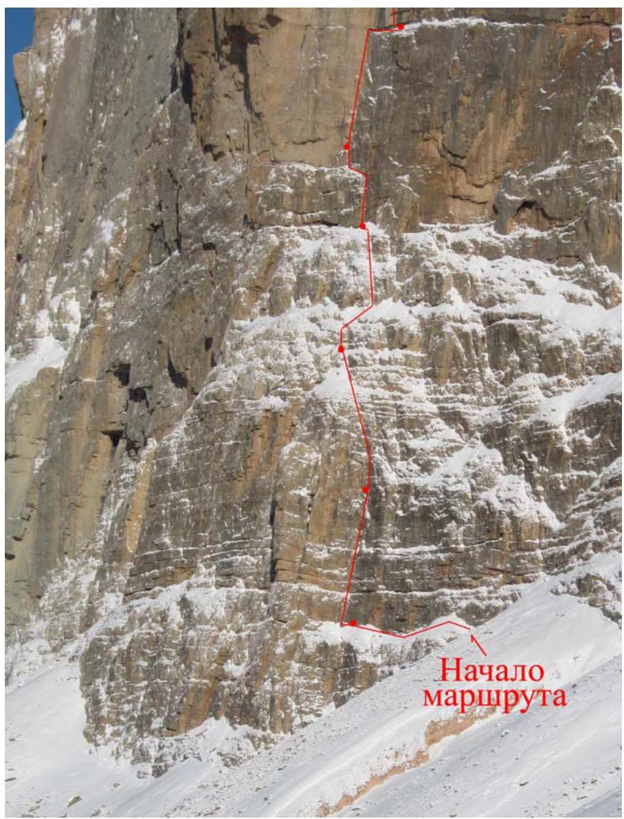
Ascent schedule

| Date | 30 January | 31 January | 1 February | 2 February | 3 February | 4 February | 5 February | 6 February | 7 February | 8 February | 9 February | 10 February |
|---|---|---|---|---|---|---|---|---|---|---|---|---|
| Temperature | –10 °C | –10 °C | –5 °C | –2 °C | –8 °C | –12 °C | –22 °C | –15 °C | –10 °C | –8 °C | –10 °C | –10 °C |
| Weather | Wind medium, overcast | Wind medium, cloudy | Wind weak, cloudy | Wind weak, clear | Wind weak, cloudy | Light snow, cloudy | Heavy snow, overcast | Wind strong, cloudy | Wind strong, clear | Wind strong, cloudy | Wind weak, cloudy | Wind weak, cloudy |
| Work time | 11 h | 9 h | 9 h | 9 h | 9 h | 9 h | 5 h | 9 h | 9 h | 9 h | 7 h |
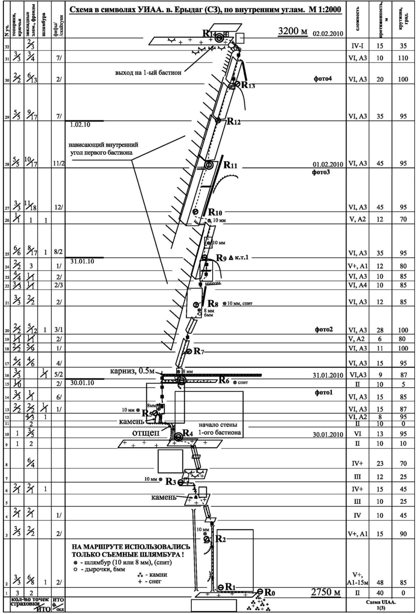
Description of route sections
R0–R1: Simple traverse 35–40 m along a wide (1–2 m) long ledge to a large crack-fissure. Safe belay station before the crack, 4 m away.
R1–R2: Up the crack 48 m, slightly overhanging in places, with some jamming. Good spot for a belay station after the overhanging section on the edge (there is a Ø10 hole for a removable bolt).
R2–R3: Along the fissure turning into a crack (15 m), exit to a small ledge. Then direction up-left:
- first along the inner corner (10 m),
- then along a sloping ledge with a stone (10 m),
- and further through a small wall with a wide gap to a ledge before the "ram's foreheads" (15 m).
Here is a belay station on an anchor and a removable Ø10 mm bolt.
R3–R4: From the station:
- up-right through the "ram's foreheads" (12 m) to the start of a small inner corner,
- then movement along it up-left (23 m) to a large ledge abutting the wall section of the 1st bastion,
- along the ledge traverse left (10 m) to the base of a splintered rock.
Here is a good spot for a belay station and overnight stay, and the last place on the 1st bastion where snow can be gathered.
R4–R5: Up a small chimney formed by a splinter (13 m, large camalots), then traverse left along the splinter (10 m) and onto an inclined boulder to its top (8 m, AID A2). Belay station on a removable Ø10 bolt and топориках. Here begins the complex wall section of the 1st bastion.
R5–R6: Movement towards the start of a long ledge with a cornice, AID A3. Initially up through a system of disappearing cracks (there is a Ø8 hole for a bolt), then up-left (15 m). Further up along a vague crack to a ledge (15 m). Along the ledge traverse right 10 m (first 3 m crawling), here in the center of the smooth wall is a piton (belay station) and further 1.5 m away is a Ø10 mm hole for a 2nd platform.
R6–R7:
- up the small wall (2 m) 1.5 m left of the piton (left of the black streak) on fiffs under the cornice (0.5 m),
- on the cornice, a Ø8 mm hole for a removable bolt and Ø6 mm for a skyhook,
- then on fiffs to the start of an overhanging corner — 9 m (belay on топориках (anchors)).
Movement along the corner right-up — 15 m, rock crumbles, points unreliable, AID on camalots, anchors, and fiffs. From this station, almost all movement to the end of the 1st bastion goes along a system of overhanging corners, and it's convenient to use a "hook-bag".
R7–R8: Continuing movement right-up. Rock crumbles, points on camalots, anchors, and fiffs – 11 m, A3. Then transition under the next overhanging corner – 6 m. Along the overhanging corner up to the disappearance of the crack with further transition to its left edge (there is a Ø6 hole for a skyhook and Ø8 for a removable bolt) – 28 m, A3. Belay station on a piton and a removable Ø8 bolt.
R8–R9: Up the right part of the small wall (rock destroyed) – 12 m. Further complex section along several disappearing cracks (fiffs, топориках) and relief skyhooks right-up about 10 m, A4; direction — to the start of a thin crack on the right face of the next inner corner. Then first along one crack (10 m, A3), and then after a small ledge along another crack (12 m, A1) to the top of the protrusion. Here is a comfortable belay station and the 1st control tour.
R9–R10: Movement up along the inner corner – 35 m, A3. To pass, it's necessary to use all climbing equipment, belay is unreliable, AID on camalots, fiffs, anchors, топориках, relief skyhooks (in the middle on the small wall, a Ø10 hole for a removable bolt). Further is a logical transition (12 m) left into the next large inner corner, the top of which leads to the roof of the 1st bastion. Almost no belay, on a smooth slab, a hole from a Ø10 mm removable bolt.
R10–R11: Movement up-right along an overhanging inner corner – 45 m, A3. AID on camalots, fiffs, anchors.
R11–R12: Continuing movement along the corner – 45 m, A3. Belay is unreliable, AID on camalots, fiffs, anchors, топориках, relief skyhooks.
R12–R13: First movement along the crack on the right face of the corner, then transition into the corner itself (camalots) – 20 m, A3. Here the corner becomes more overhanging, and in some places, it's necessary to "weed out" moss for access to the relief. Then the corner becomes even more overhanging, the right face ends with a protrusion, and the crack becomes thin (fiffs, chocks, small camalots) – 10 m, A3. Further movement up-left, the crack widens and turns into a fissure leading to a large wide ledge. Along the ledge a few meters along the small wall to a crack where a belay station can be organized. Poor voice communication. The 1st bastion is passed!
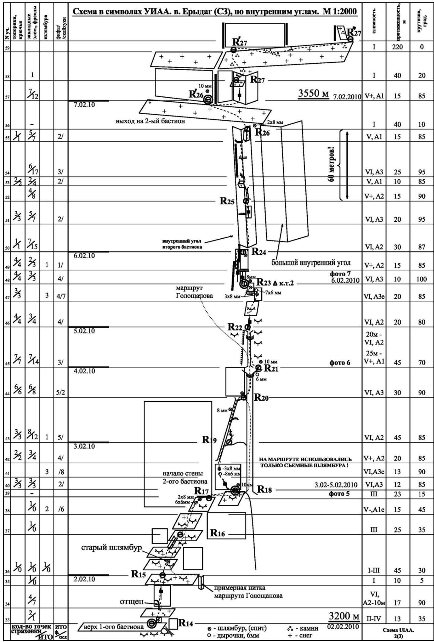
R14–R15: Up through a small wall (2 m), then slightly right along a ledge under a wall with a wide crack, which then narrows. Along the wall initially along the edge of the splinter, then along the crack with a transition in the upper part to a crack starting on the left (AID, A2–10 m). Then along a wide gentle ledge to the first convenient spot where a belay station can be set up.
R15–R16: Simple section along "ram's foreheads" in the direction of the wall section of the 2nd bastion. Initially straight (after about 15 m, an old bolt is found), then up-right. Total about 45 m. In summer, everything is climbed without belay.
R16–R17: Up to the wall section (~25 m) and further right along a large "ram's forehead" – 15 m. Along the forehead, AID on small holes, in summer it's climbed on friction.
R17–R18: Traverse (23 m) right along the wall to the end of the ledge to a convenient spot for an overnight stay, here two Ø10 mm holes for platforms (in summer they will be high). To the right, the ledge breaks off, and a wide destroyed groove with smoothed edges goes up. The Goloshchapov route presumably passes along this groove. It seemed that movement along it is objectively hazardous, and the most logical continuation is to pass the wall on the left, exiting into the base of a wide inclined crack, which also leads to the top of this groove. The overall direction is towards an unclimbed inner corner located on the left face of a clear large corner separating the top of the 2nd bastion.
R18–R19: From the station left (~3 m) to a large "bump" forming a crack. Along the crack (12 m) to the top of the "bump" (AID on chocks, fiffs, anchors), then along small holes (Ø6 mm) and removable bolts (Ø8 mm) up a steep wall (13 m) to the base of a crack. Along the crack (20 m) to a convenient spot for a belay station on a small ledge. The crack is partially destroyed.
R19–R20: From the station up the right slit (on camalots) and further along the crack (camalots, fiffs, anchors) to the junction with the groove – 45 m. Here is an old bolt.
R20–R21: Along the groove up (strongly destroyed), through an overhang, further right through a small nose (hole skyhook Ø6 mm), an inconvenient belay station (one of the points is a Ø10 mm removable bolt) – 30 m, A3.
R21–R22: Further along the continuation of the groove (here somewhere the Goloshchapov route turns left) to a "cat" (~25 m, A1), and then through it in the same direction along a crack (~20 m, A2). The real complexity is hard to assess due to the work after a heavy snowfall.
R22–R23: Along "ram's foreheads" along destroyed disappearing cracks under an inclined wall – 20 m. Further, a small destroyed niche is bypassed on the right, and above it, a traverse left (AID on hole skyhooks, sometimes fiffs, топориках). We approach under an overhanging wall with three cracks located at the base of the corner leading to the 2nd bastion. Here is the 2nd control tour left on an anchor.
R23–R24: Along the middle crack up, then transition to the left crack and exit to the left edge of the corner. 10 m. Along the edge up, and then a small traverse right under the overhang of the left face of the corner – 15 m. Safe belay station (one of the points is a Ø8 mm removable bolt) not reaching 1 m to the crack formed by this corner.
R24–R25: Up along the inner corner. In the upper part of the section, transition to a crack on the right face. The corner is partially overhanging, AID on large camalots, sometimes fiffs and anchors.
R24–R26: First along a wide crack (15 m) to the left face of the edge, then along the edge of the face (10 m), and then again along the crack in the center of the inner corner to its end (15 m), using large and medium camalots as points, sometimes fiffs and anchors. From the crack right into a small corner – 15 m, leading to the roof of the 2nd bastion. At the top of the corner, a belay station on two removable Ø8 mm bolts. The total distance from the previous station is over 50 meters! The rope was extended! The 2nd bastion is passed.
R26–R26': On foot left along the ledge to a small wall where it's convenient to organize an overnight stay on platforms.
R26'–R27: From the overnight stay right, opposite the exit from the route, along a small wall with a good crack for AID (A1, medium camalots) straight up, almost reaching the start of the next large scree ledge. (Other descriptions mention a variant of bypassing the entire wall on the left (about 200–300 m)).
R27–R27''': Approach up under the wall of the 3rd bastion 40 m (R27'), then traverse about 200–250 m right under the belt of rocks to the exit of the Radoshkevich route (R27''). Further left to the outer corner 30 m (R27''').
R27'''–R28: Right of the outer corner along the inner corner with a slit to a small ledge 30 m, where a convenient belay station can be set up (there is an old bolt).
R28–R29: Right through a small overhang again along the corner 23 m, exit to a wide ledge.
R29–R30: Along a slit turning into an inner corner and through a "ceiling" with a pendulum (1.5 m) – 25 m. Further right around the outer corner along a system of oblique slits to a small gentle ledge – 17 m. There is an old hole for a Ø8 mm removable bolt.
R30–R31: Up along a wide slit to a large ledge 15 m. Convenient spot for a belay station, there is an old bolt.
R31–R32: Through an inclined ledge to an inner corner and along it to a wide ledge-terrace before the last rock belt. Belay station on several large rock blocks.
R32–R32': Traverse right under the rock belt with a cornice to a spot with an inner corner having the least overhang (about 250 m).
R32'–R33: Through an overhanging inner corner and a "ceiling" (1.5 m) exit into an inner corner and along it to the scree. A belay station can be made slightly higher on the right on a bend in the scree. The wall section of the route is passed!
R33–summit: Along the top of the scree to a rock step between two small walls. Further up along the slopes along the simplest path up to the edge (carrying heavy backpacks is difficult). Along the edge right, exit to a plateau and further left to the summit of Erydag (NW), 3887 m!
Note:
The route can be divided into three main parts:
- 1st bastion — elevation gain 450 m, steepness up to 86 °, from R5 to R14 constantly overhangs, no snow, comfortable belay stations only on R6 and R9.
- 2nd bastion — elevation gain 350 m, from R17 to R26 no snow (in good weather), comfortable belay station R20.
- 3rd bastion — pre-summit belts, elevation gain 200 m, uncomfortable belay station only R30.
Technical photograph of the route
Information about the presence of notes
During the ascent, the group created two control tours in the middle of the first and second bastions (stations R9 and R23), where notes on the first ascent were left. Initially, the route was planned to be named "Pravee bastiona 'NOS'" (Right of bastion 'NOS'), and this name is indicated in the notes. After completing the route, the most natural and characteristic name was deemed to be:
- "po vnutrennim uglam pravogo bastiona SZ steny" (via the inner corners of the right bastion of the NW wall).
No note was found in the summit tour. The group left their note in an iron pipe, visible in the photograph of the participants on the summit.
Photo illustration of the route via the inner corners of the right bastion of the NW wall of Erydag (NW), 3887 m.
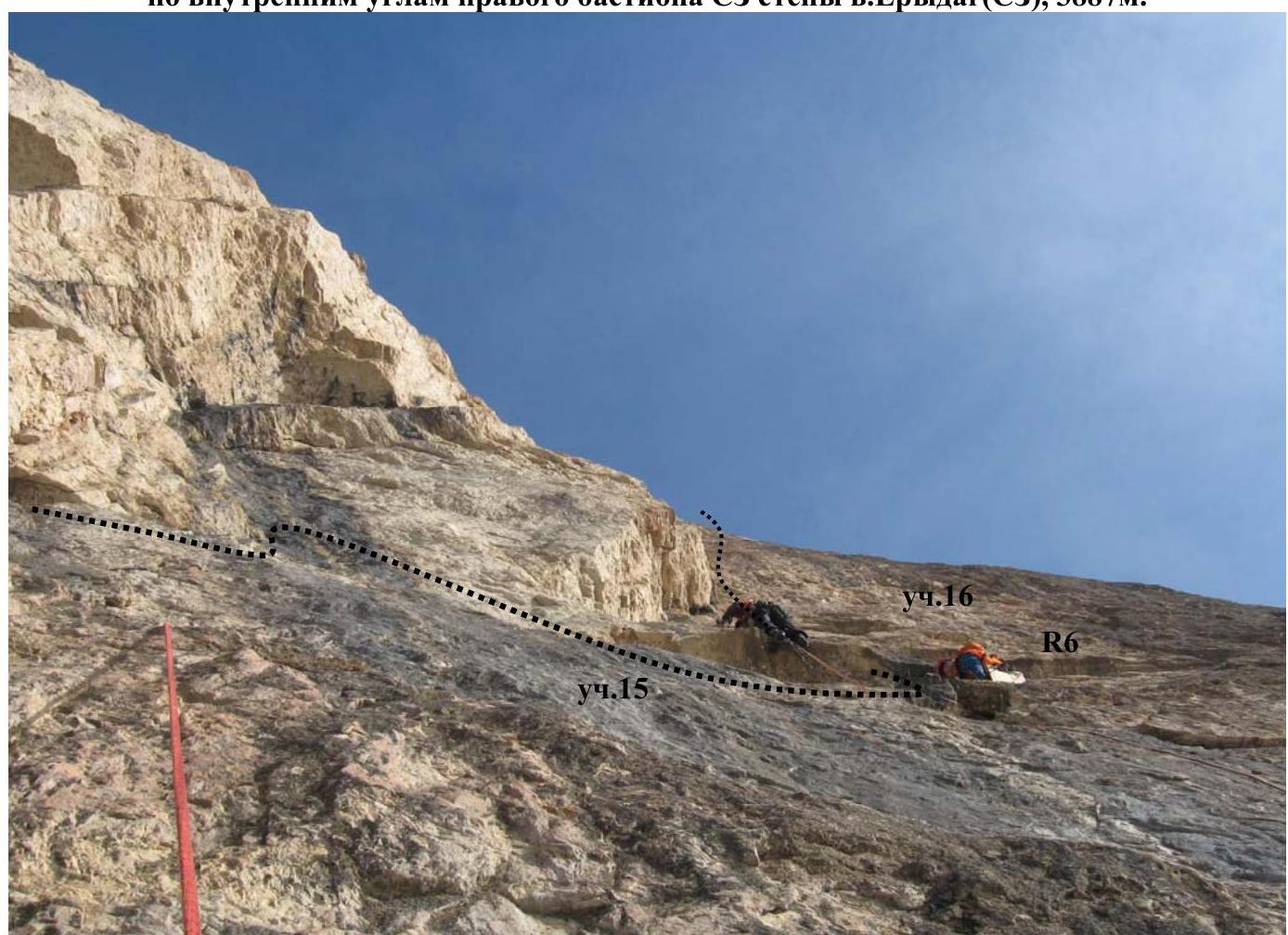
Photo 1. Work at the start of section 16 (station R6). First is Igor Viskov, belay is Ruslan Kirichenko.
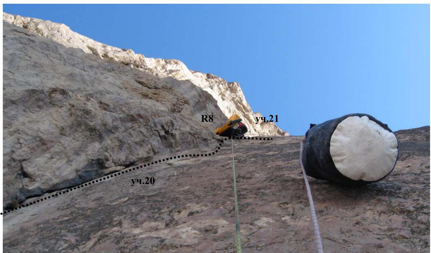
Photo 2. Section 20. Transfer from R6 to R11. At station R8 is Dmitry Krasnov.
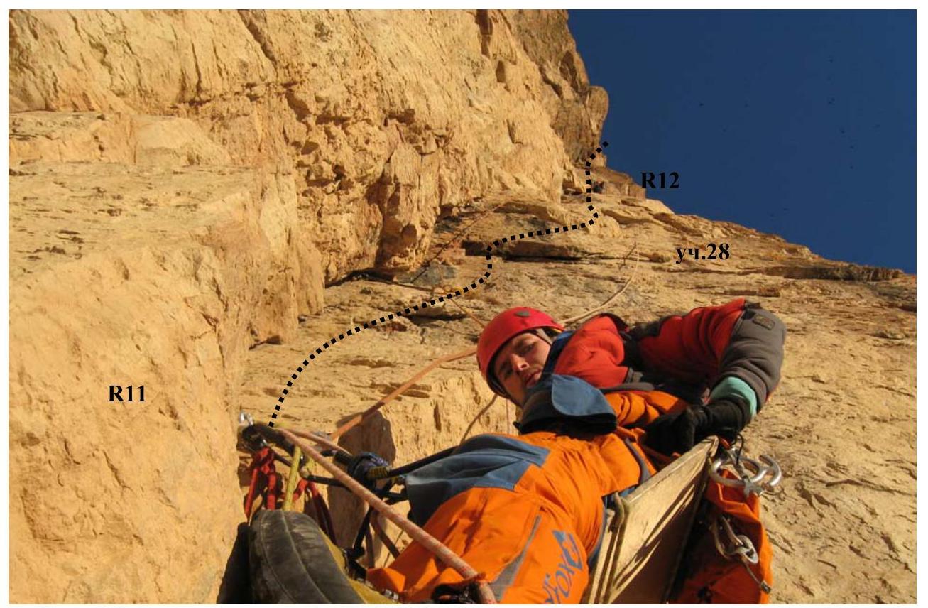
Photo 3. Work on section 28 (R11–R12). Ruslan Kirichenko belays Igor Viskov.

Photo 4. Overcoming sections 30–31. Completion of the wall section of the 1st bastion. First is Oleg Koltsunov. Photo from R13.
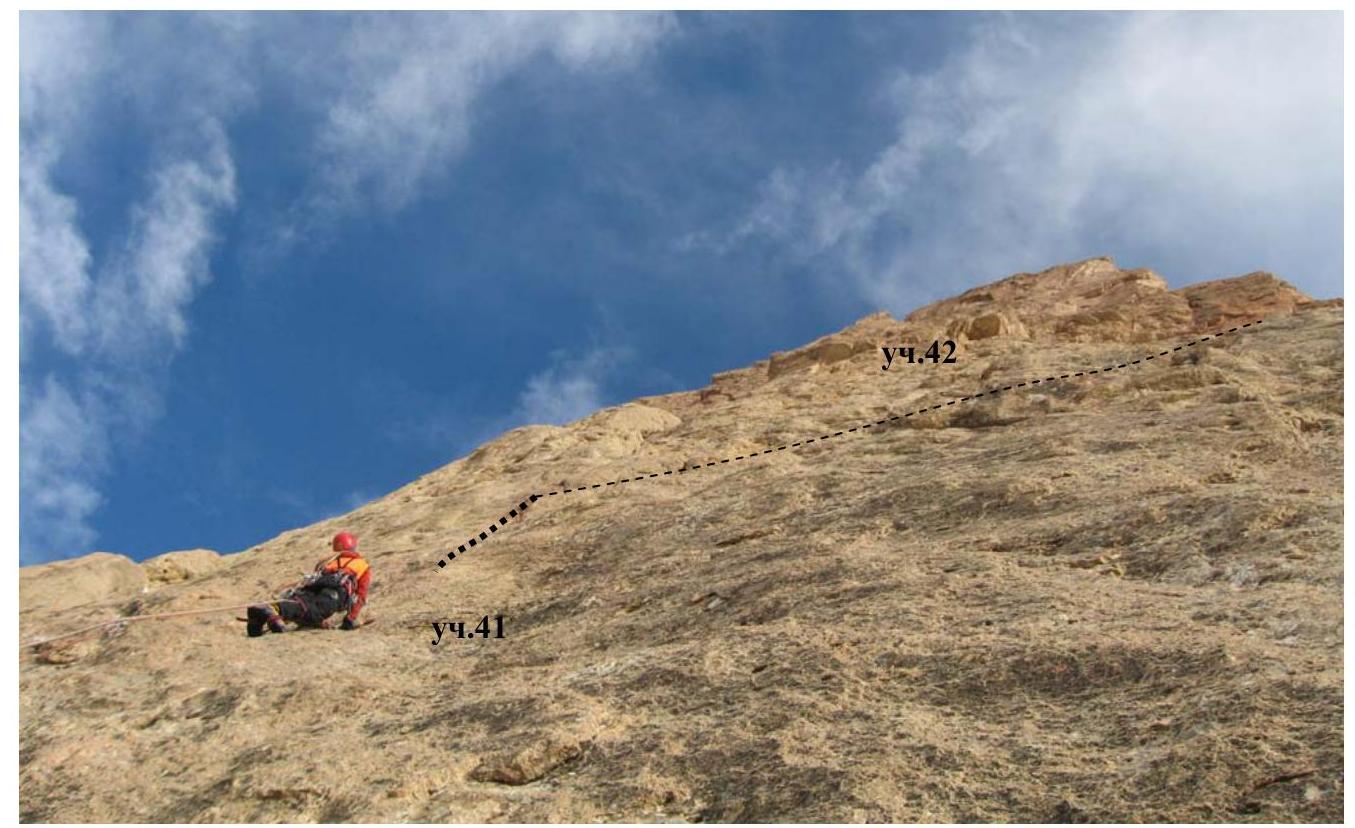
Photo 5. Start of the wall section of the 2nd bastion. Oleg Koltsunov on section 41. Section 42 is poorly visible behind the edge overlapping the wall. Photo from R18.
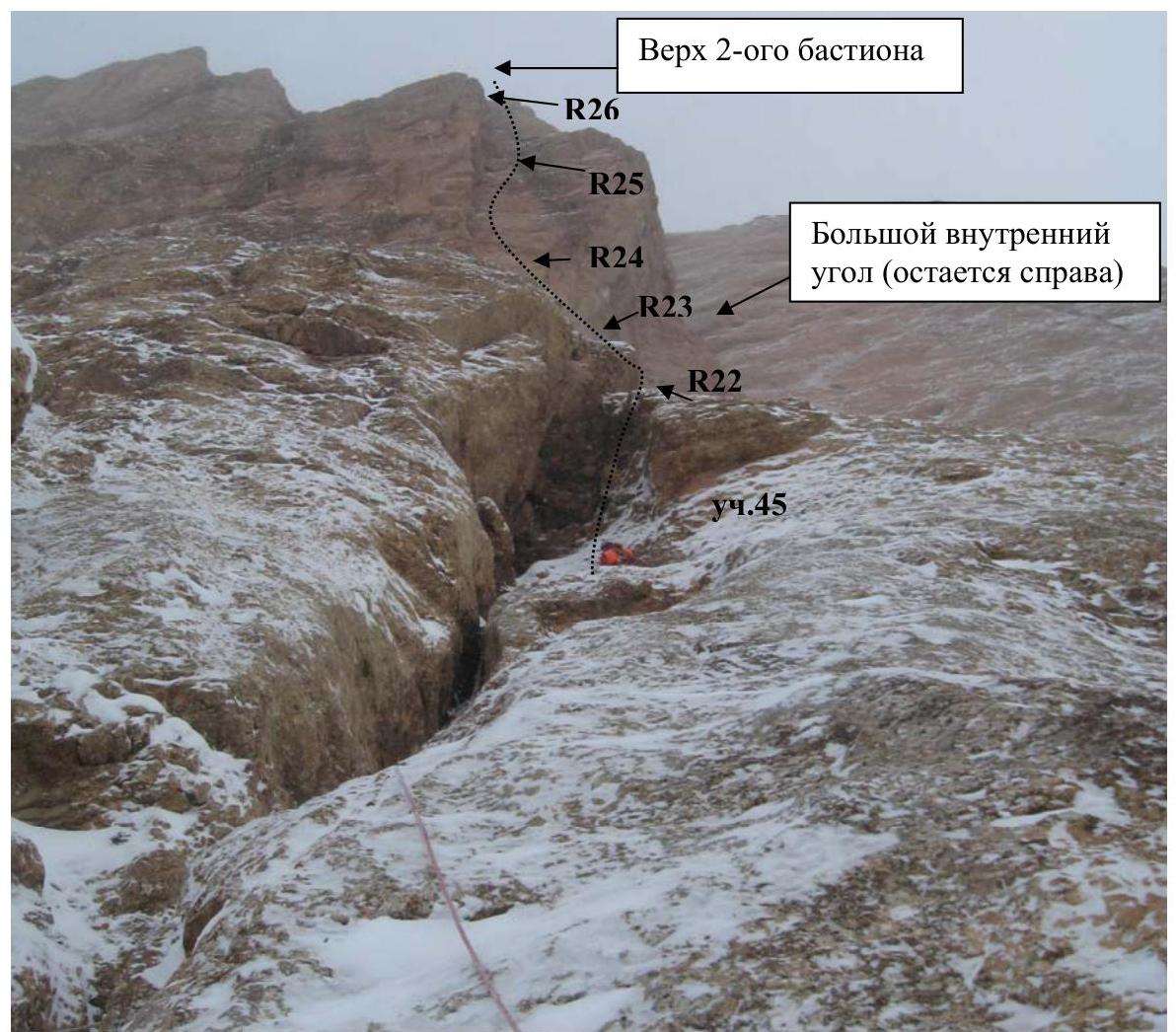
Photo 6. After a night snowfall. In the break between snowfalls. Dmitry Krasnov on section 45. Photo from station R21.
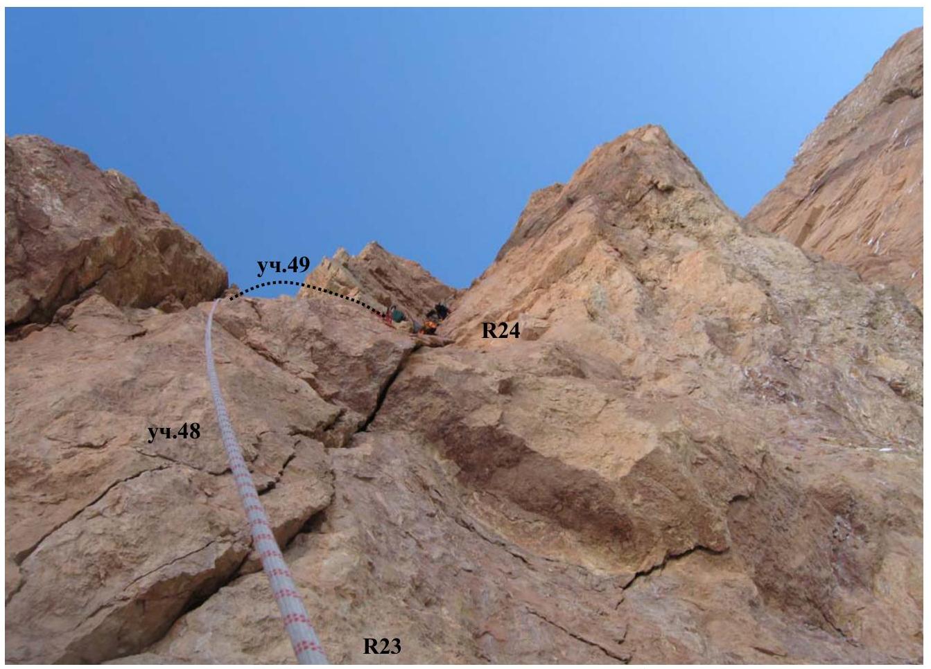
Photo 7. Start of the inner corner on the 2nd bastion. Oleg Koltsunov is visible on section 50. Photo from station R23.
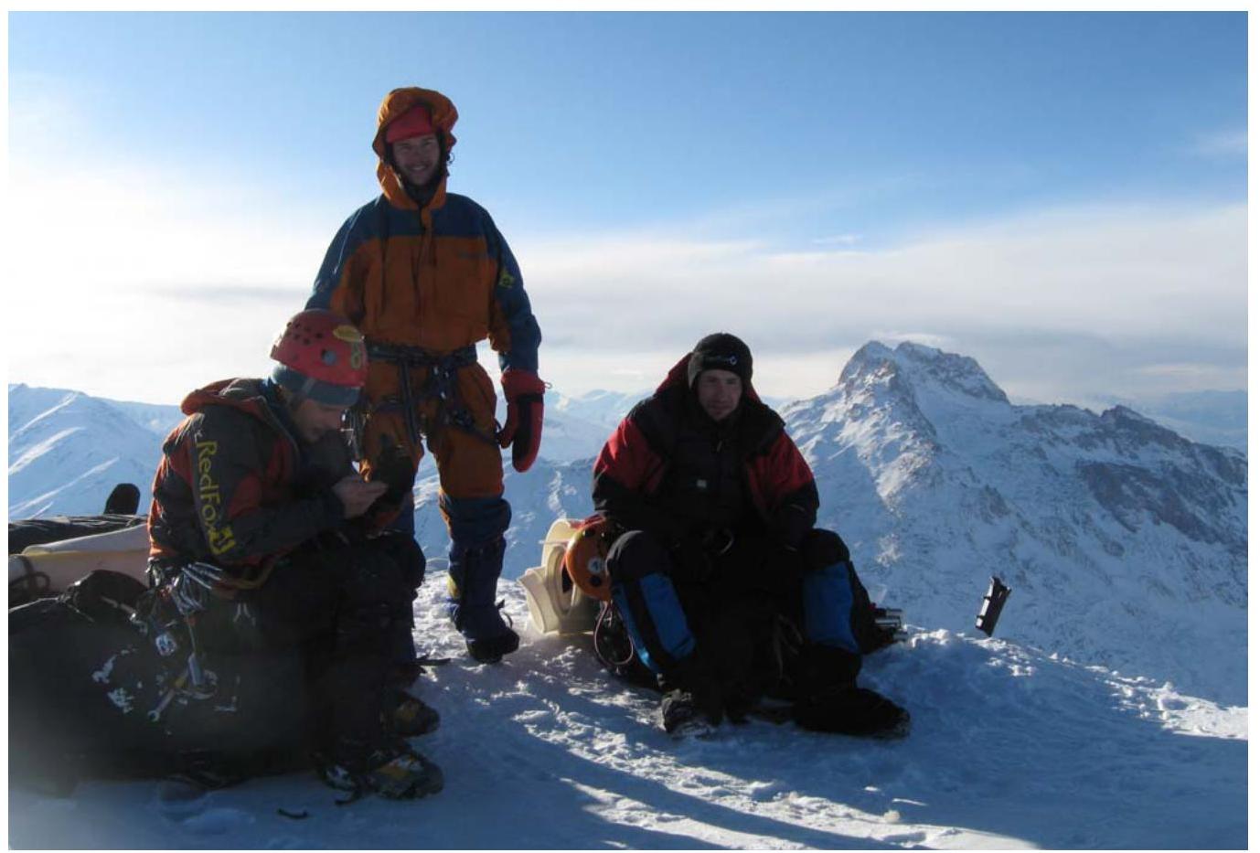
Photo 8. Summit! Oleg Koltsunov, Ruslan Kirichenko, Igor Viskov. Photo by Dmitry Krasnov.