In Memory of Sergey Volkov
Russian Mountaineering Championship 2004
First Ascent Category
Report
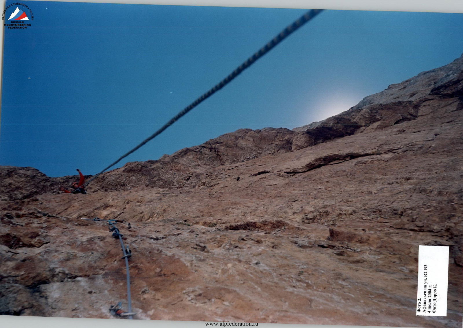
On the ascent of Mt. Erydag (3925 m) via the cornices on the right part of the NW wall by the team from the Dagestan Alpine Federation (Dagestan Search and Rescue Team, EMERCOM of Russia)
Ascent Passport
- Region 2.10, Dagestan mountains, Chekhychay gorge.
- Erydag (3925 m), via cornices on the right part of the NW wall.
- Proposed category: 6B; first ascent.
- Route type: rock climbing.
- Elevation gain: 825 m; route length: 1245 m; wall height: 545 m (by altimeter); wall section length: 665 m. Of these, 235 m were climbed using free climbing — VI category: 105 m, V category: 100 m, IV category: 20 m, II category: 10 m; 430 m were climbed using artificial technical aids (ITO) — A3: 95 m, A2: 265 m, A1: 70 m; average wall angle: 86°; overall route angle: 65°.
- Insurance points left on the route: 15
- removable piton hooks: 6
- "spit" (for overnight stay): 2 (1 with an "eye")
- rock anchors: 6
- chock stones: 1
- Total ITO used on the route: 434
- ITO created using skyhooks, anchors, and ice axes: 241
- Total insurance points used, including ITO: 305/193
- Breakdown:
- rock anchors: 81/42
- chock stones: 70/36
- piton hooks (all removable, 8 mm): 154/115
- Team's total climbing hours: 152.5; days: 15. Time spent by the "lead" climber on the route: 107.5 hours.
- Team leader: Shanavaz Shanavazov Eldarovich — Master of Sports (Makachkala)
Team members:
- Konstantin Dorro Eduardovich — Master of Sports (Makachkala)
- Oleg Bibin Yuryevich — Master of Sports (Saratov)
- Vitaly Afanasyev Yuryevich — Candidate for Master of Sports (Maikop)
- Maxim Bukonin Borisovich — 1st sports category (Saratov), with experience in 6A category routes
- Senior coach: Ziyabudin Murtazalievich Murtazaliev (Makachkala) Coach: Ivan Ivanovich Serdyukov (Saratov)
- Start of work on the route: July 1, 2004 Installation of a platform at the intermediate camp: July 14, 2004 Summit ascent: July 19, 2004 Bad weather: July 2, 10, 11, 2004 Rescue operations on Mt. Sel'dy, 4B category: July 7, 2004
- Team: Dagestan Alpine Federation (Dagestan Search and Rescue Team, EMERCOM of Russia)
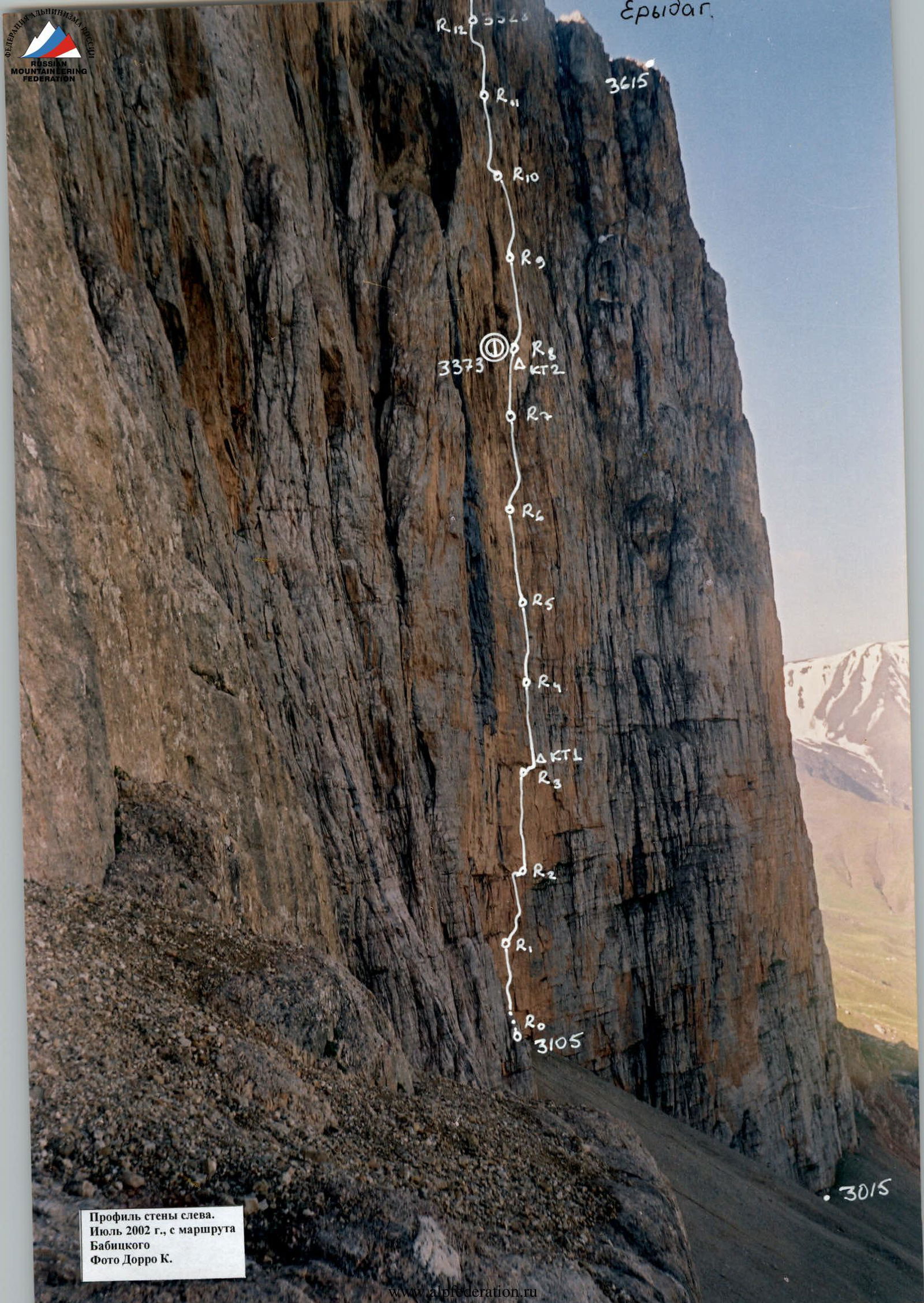
Profile of the wall on the left.
 July 2002, from Babitskiy's route. Photo by K. Dorro.
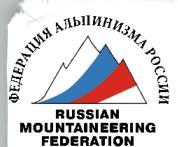
Drawn profile of the Erydag (3925 m) route via cornices on the right part of the NW wall. Sh. Shanavazov, 2004. July 1–19.
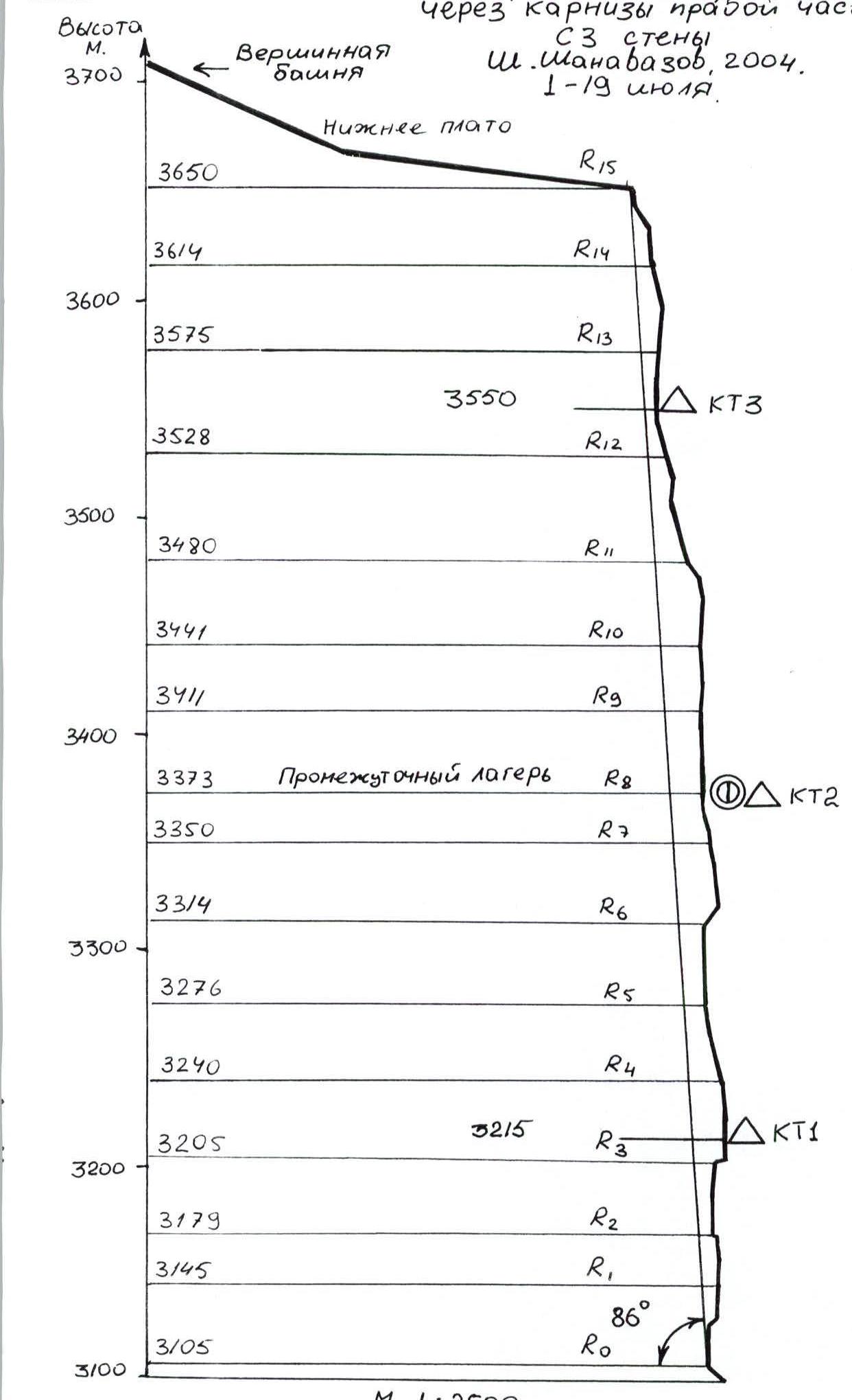
 Panorama of the area. December 2003, photo by K. Dorro from the slopes of Mt. Shalbuzdag at 3400 m.
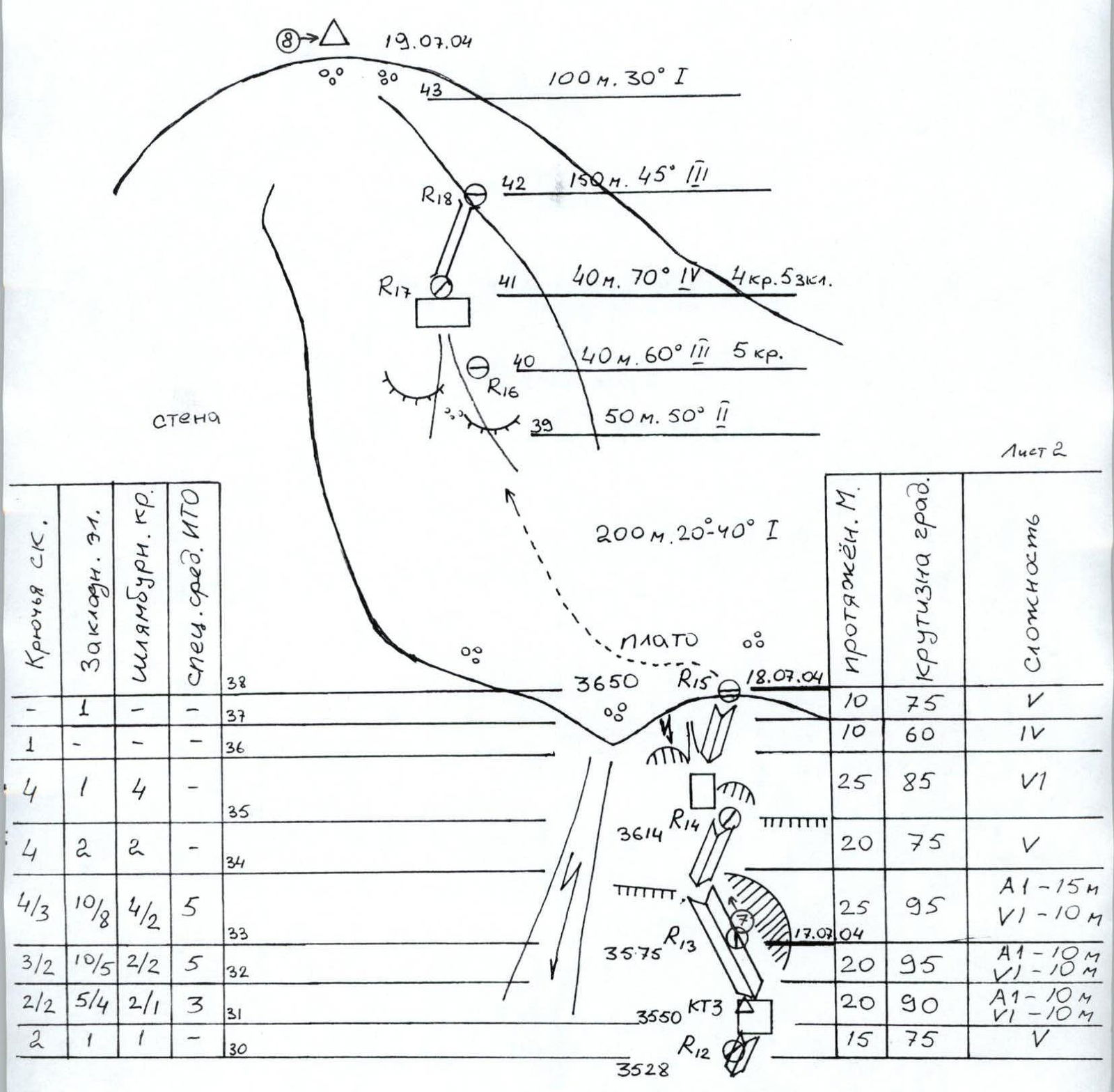
- 5A — V. Ruchka, 1980
- 5A — E. Radoshkevich, 1980
- 6A — K. Dorro, 2002
- 6A — V. Goloshchapov, 1983
- 6A — S. Voronin, 2001
- 5B — E. Radoshkevich, 1981
- 6A — A. Andreev, 2001
- 6A — G. Shchedrin, 1981
- 6A — S. Efimov, 1981
- 6A — A. Babitskiy, 1981
- 5B — S. Belousov, 1986
- 6A — A. Mikhailov, 1982
- 5B — S. Feldman, 1980
- — Sh. Shanavazov, 2004
- 5B — P. Leonov, 1996
- 5B — K. Dorro, 2000
- 5B — V. Pleskachevsky, 1987
- 5B — M. Polyakov, 1980
- 5B — A. Samoded, 1980
- 5B — S. Smotrov, 1998
- 5B — A. Nekrasov, 1986
- 5A — M. Dubovikov, 1981
- 5A — A. Nezametdinov, 1979
- 4B — A. Sidorenko, 1979
- — E. Pashuk, 2004
Overview of the Climbing Area
The Erydag massif is located on a short northeastern spur of the Main Caucasian Range, on the border between Russia and Azerbaijan. It forms a nearly continuous plateau with Mt. Yarudag and Mt. Shakhdag. The Dagestan side features walls 300–1100 m high, with a total length of about 15 km. The wall is composed of metamorphosed limestone. The climate is dry, but with more precipitation in May–July. Winters are cold and dry, with periods of strong winds and precipitation (not more than 2–3 days). A significant issue on the wall is the lack of water, which can occur even in winter; snow does not stay on the wall due to being blown away, and because of the dry air, it evaporates without melting.
To reach the climbing area from Makachkala, take the federal highway "Kavkaz" south to the village of Novo-Gopci (180 km), then turn right and head up the Samur River to the village of Usukhchai (225 km, 700 m above sea level). From there, turn left onto a dirt road that follows the Usukhchai River up to the village of Kurush (250 km, 2500 m). The journey takes about 6–8 hours. From Kurush, descend along a path to where the Sel'dy River joins the Chekhychai River (2250 m). To the right, on a terrace (left bank), is the "Erydag" base camp of the Dagestan Republican Rescue Team (30 minutes). It's possible to drive there by car. Continue through two bridges to a terrace (right bank), then slightly left towards the NW wall of Erydag, to the area known as "Polyakov's shelf." At an elevation of 2900 m, reach a ridge ("bump") with a large cairn, and from there, go left and down about 100 m to a convenient grassy area with large stones. Here is a stream. On the shelf, near the stones, a large circle is laid out. This is where the ABC camp is located at 2880 m, on the line of a long dark streak between the Polyakov and Samoded routes.
From the Erydag base, it takes 2.5 hours to reach the ABC camp. From ABC, traverse grassy slopes for 10–15 minutes without gaining height, bypassing large boulder scree from below, and approach the scree slope that leads to the scree arc under the wall. Go up the scree, staying at least 100 m away from P. Leonov's route, and reach the start of the route under the protection of cornices at 3105 m. From ABC, it takes 1 hour. Caution: beware of falling rocks after rain and snowfall!
The team's route leads to the lower plateau of Erydag, to the base of the summit tower, where a 3A category route begins. From there, ascend to the summit; or alternatively (longer), bypass the summit tower from the south and follow a broad couloir with a 1B category difficulty. Descend from the summit with a 1B category difficulty and continue, bypassing Mt. Sel'dy on the left, down to the "Gates" area near the Kurush pass. After rain and snowfall, the plateau becomes water physiology changes, turning into a clayey swamp.
The route is characterized by a maximum steepness and complexity, although with a relatively modest elevation gain (545 m and 86°). For comparison, the Kjukkyurtlyu wall has a height difference of 470 m and an angle of 83°. The wall in this section (between the Feldman and Leonov routes) is concave, like a lens, and only before reaching the plateau does the steepness decrease to 80°.
During the ascent, the team aimed to maximize the use of free climbing. They strived to make belay stations as reliable as possible and utilized micro-relief when climbing with ITO (almost no "skyhook holes" were used). Some sections were climbed on unreliable, crumbling terrain. The team used a full set of rock climbing gear, including for ITO, and employed removable piton hooks. The lead climber worked on the wall for an average of 8 hours per day, while the rope team worked for 10 hours. The extremely difficult, steep, and sometimes unreliable terrain did not allow for more than 6–7 meters of progress per hour. The lead climber and the belayer had autonomous food and water supplies.
The route is technically challenging and tactically complex due to the lack of water and the problematic descent in case of an "abort." The team had to rope the entire wall before making the final ascent. The weather was unstable, with cold temperatures, snowfall, and occasional drizzle.
The route line was chosen to minimize exposure to rockfall by taking advantage of the protection offered by cornices. To avoid the danger posed by the "kara" (to the right of the Feldman route), the team decided not to traverse the second cornice from the left to avoid being exposed.
The route's complexity and the intensity of the work are comparable to routes on Mt. Kjukkyurtlyu by Grigorov (6B) and Andreev (6B). The team's route is more challenging than LukaShvili's route (6B) on Mt. Kjukkyurtlyu.
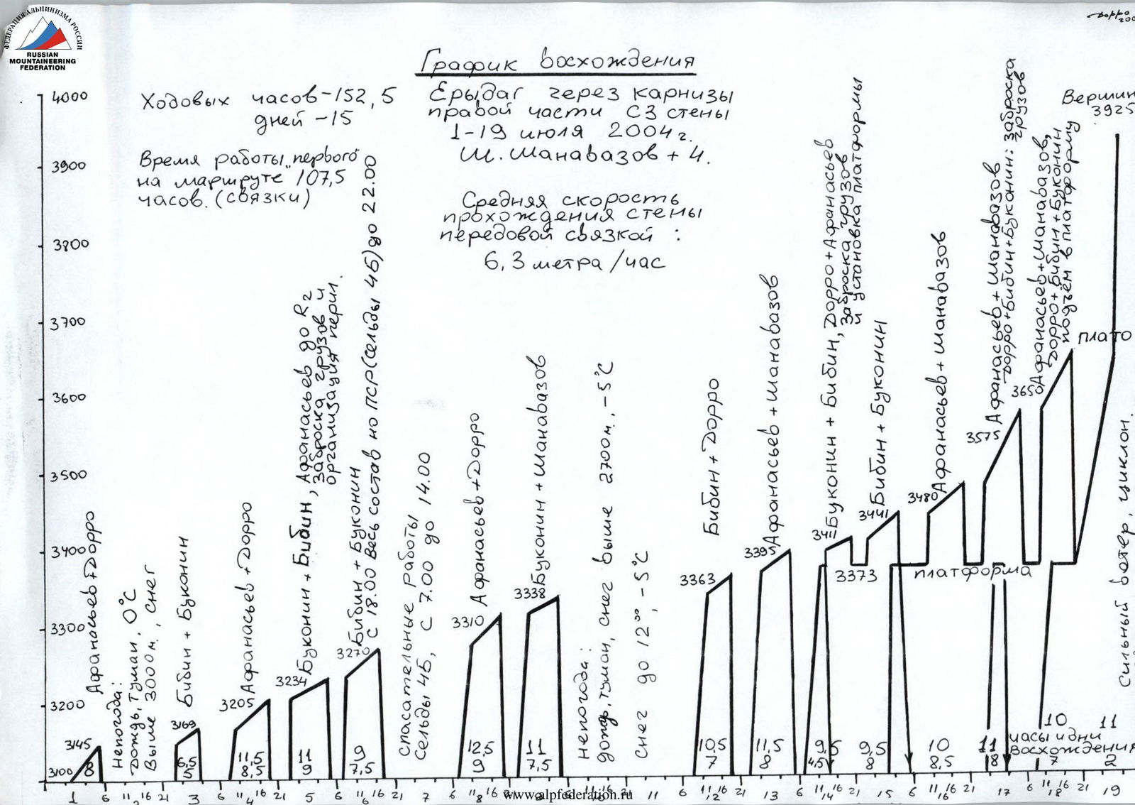
Ascent Schedule
Erydag via cornices on the right part of the NW wall. July 1–19, 2004. Sh. Shanavazov + 4.
- Total climbing hours: 152.5; days: 15.
- Time spent by the "lead" climber on the route: 107.5 hours (for the rope team).
- Average speed of wall climbing by the lead rope team: 6.3 m/h.
Notes (from the schedule):
- Bad weather: rain, fog, precipitation, snow. Above 3000 m, temperature –5 °C.
- Rescue operations on Mt. Sel'dy, 4B category, from 7:00 to 14:00.
- Bad weather: rain, fog, snow above 2700 m, –5 °C.
- Strong wind, cyclone.
- 11 hours on the first ascent day.
- Summit, 3925 m.
Route diagram in UIAA symbols. Erydag (3925 m) via cornices on the right part of the NW wall. July 1–19, 2004. Scale 1:2000. Sheet 1.
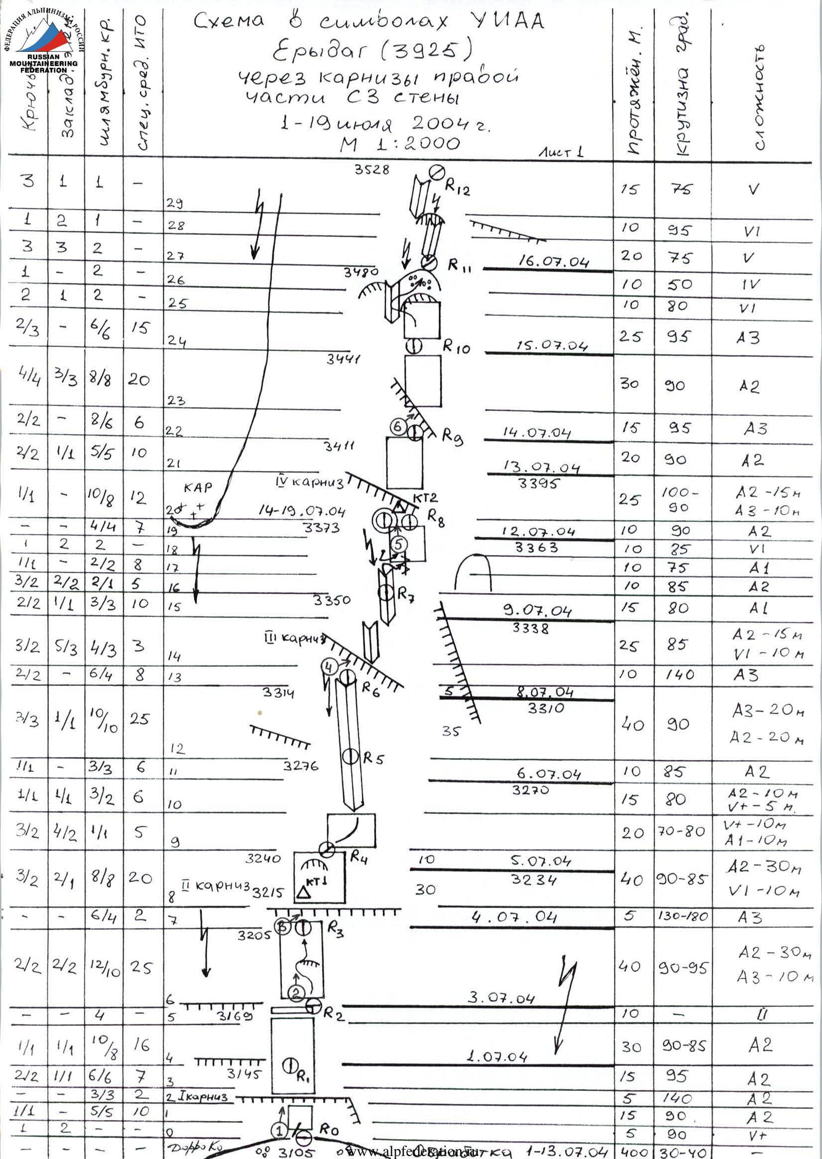
| № | Rock Anchors | Chock Stones | Piton Hooks | Special ITO | Section/Description | Date | Length, m | Angle, ° | Difficulty |
|---|---|---|---|---|---|---|---|---|---|
| 29 | 3 | 1 | 1 | – | R12 | 15 | 75 | V | |
| 28 | 1 | 2 | 1 | – | 10 | 95 | VI | ||
| 27 | 3 | 3 | 2 | – | R11 | 16.07.2004 | 20 | 75 | V |
| 26 | 1 | – | 2 | – | 10 | 50 | IV | ||
| 25 | 2 | 1 | 2 | – | R10 | 10 | 80 | VI | |
| 24 | 2/3 | 6 | 6 | 15 | 15.07.2004 | 25 | 95 | A3 | |
| 23 | 4/4 | 3/3 | 8/8 | 20 | R9 | 30 | 90 | A2 | |
| 22 | 2/2 | – | 8/6 | 6 | 14.07.2004 | 15 | 95 | A3 | |
| 21 | 2/2 | 1/1 | 5/5 | 10 | R8 | 13.07.2004 | 20 | 90 | A2 |
| 20 | 1/1 | 10/8 | 12 | – | 1st cornice | 14–19.07.2004 | 25 | 100–90 | A2–15 m, A3–10 m |
| 19 | 4/4 | – | 7 | – | |||||
| 18 | 2 | 2 | – | 12 | R7 | 12.07.2004 | 10 | 90 | A2 |
| 17 | 1/1 | – | 2/2 | 8 | 10 | 85 | VI | ||
| 16 | 3/2 | 2/2 | 2/1 | 5 | R6 | 9.07.2004 | 10 | 75 | A1 |
| 15 | 2/2 | 1/1 | 3/3 | 10 | 15 | 85 | A2 | ||
| 14 | 3/2 | 5/3 | 4/3 | 3 | 1st cornice | 25 | 80 | A1 | |
| 13 | 2/2 | – | 6/4 | 8 | R5 | 8.07.2004 | 10 | 140 | A3 |
| 12 | 3/3 | 1/1 | 10/10 | 25 | 40 | 90 | A2–20 m | ||
| 11 | 1/1 | – | 3/3 | 6 | R4 | 10 | 85 | A2 | |
| 10 | 1/1 | 1/1 | 3/2 | 6 | 6.07.2004 | 15 | 80 | A2–10 m | |
| 9 | 3/2 | 4/2 | 1/1 | 5 | R3 | 20 | 70–80 | A1–10 m | |
| 8 | 3/2 | 2/1 | 8/8 | 20 | 1st cornice | 5.07.2004 | 40 | 90–85 | VI–10 m |
| 7 | 6/4 | – | 2 | – | R2 | 5 | 130–180 | A3 | |
| 6 | 2/2 | 2/2 | 12/10 | 25 | 4.07.2004 | 40 | 90–95 | A2–10 m | |
| 5 | – | – | 4 | – | R1 | 10 | – | – | |
| 4 | 1/1 | 1/1 | 10/8 | 16 | 3.07.2004 | 30 | 90–85 | A2 | |
| 3 | 2/2 | 1/1 | 6/6 | 7 | 2nd cornice | 15 | 95 | A2 | |
| 2 | 1/1 | – | 3/3 | 2 | 1.07.2004 | 5 | 140 | A2 | |
| 1 | 1 | 1 | – | 10 | R0 | 15 | 90 | A2 | |
| 0 | – | – | – | – | 5 | 90 | V+ |
Erydag, 3925 m.
 Erydag.
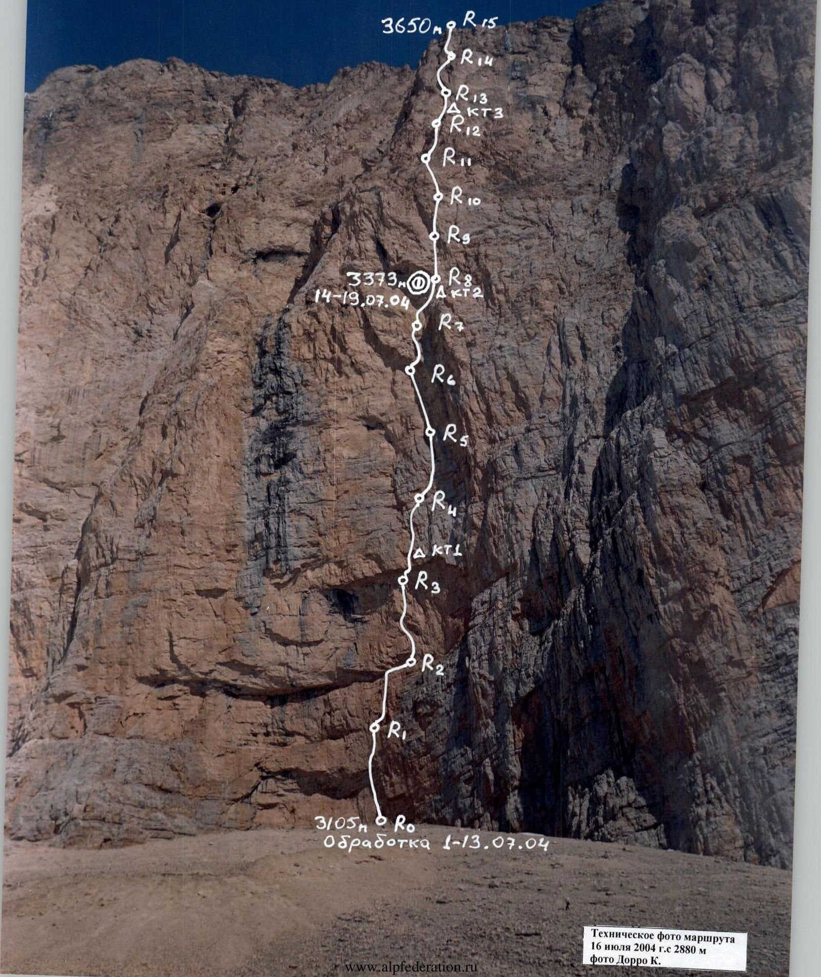 Photo 1. Afanasyev passing a cornice, section R0–R1. July 1, 2004. Photo by K. Dorro.
 Route diagram in UIAA symbols. Erydag, 3925 m, via cornices on the right part of the NW wall. July 1–19, 2004. Sheet 2.
 Technical photo of the route. July 16, 2004, from 2880 m. Photo by K. Dorro.
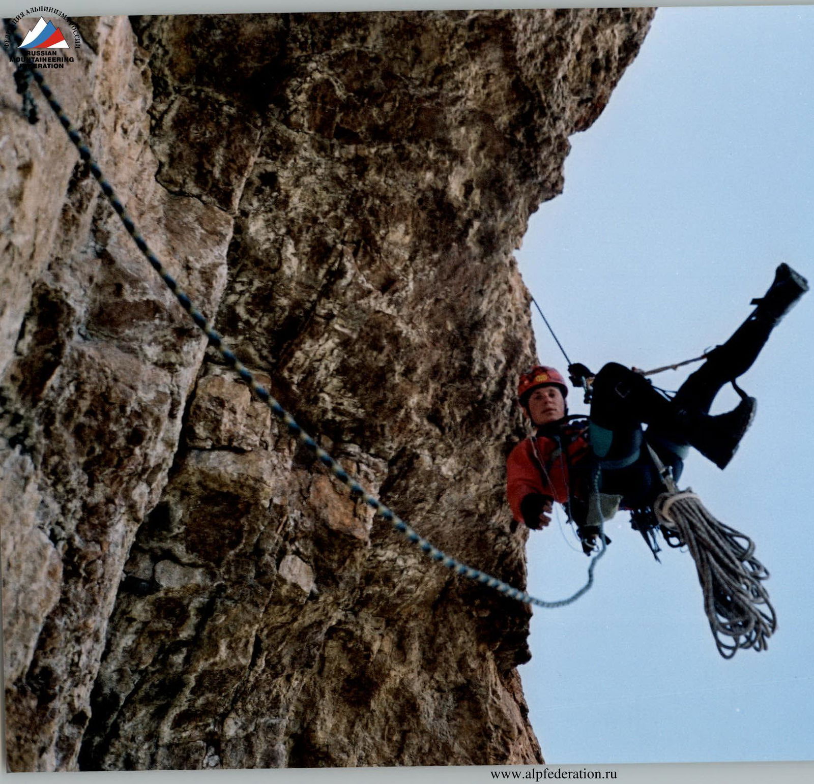
Photo 3. Afanasyev on the belay, on the 2nd cornice, section R3–R4. Preparing to process the next section. July 13, 2004. Photo by Sh. Shanavazov.
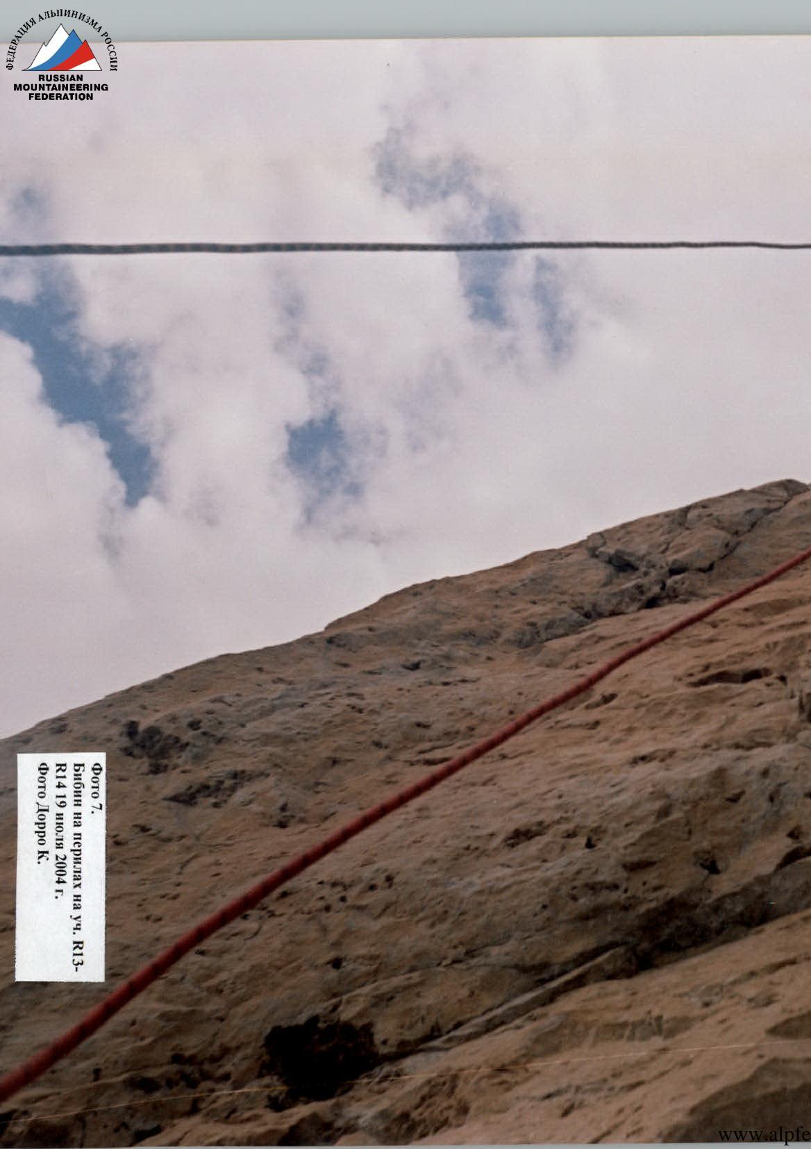
Photo 4. Bibin on the belay on the 3rd cornice, section R6–R7. Preparing to process the next section. July 12, 2004. Photo by K. Dorro.
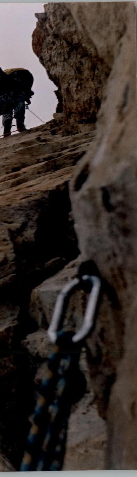
Photo 7. Bibin on the belay on section R13–R14. July 19, 2004. Photo by K. Dorro.
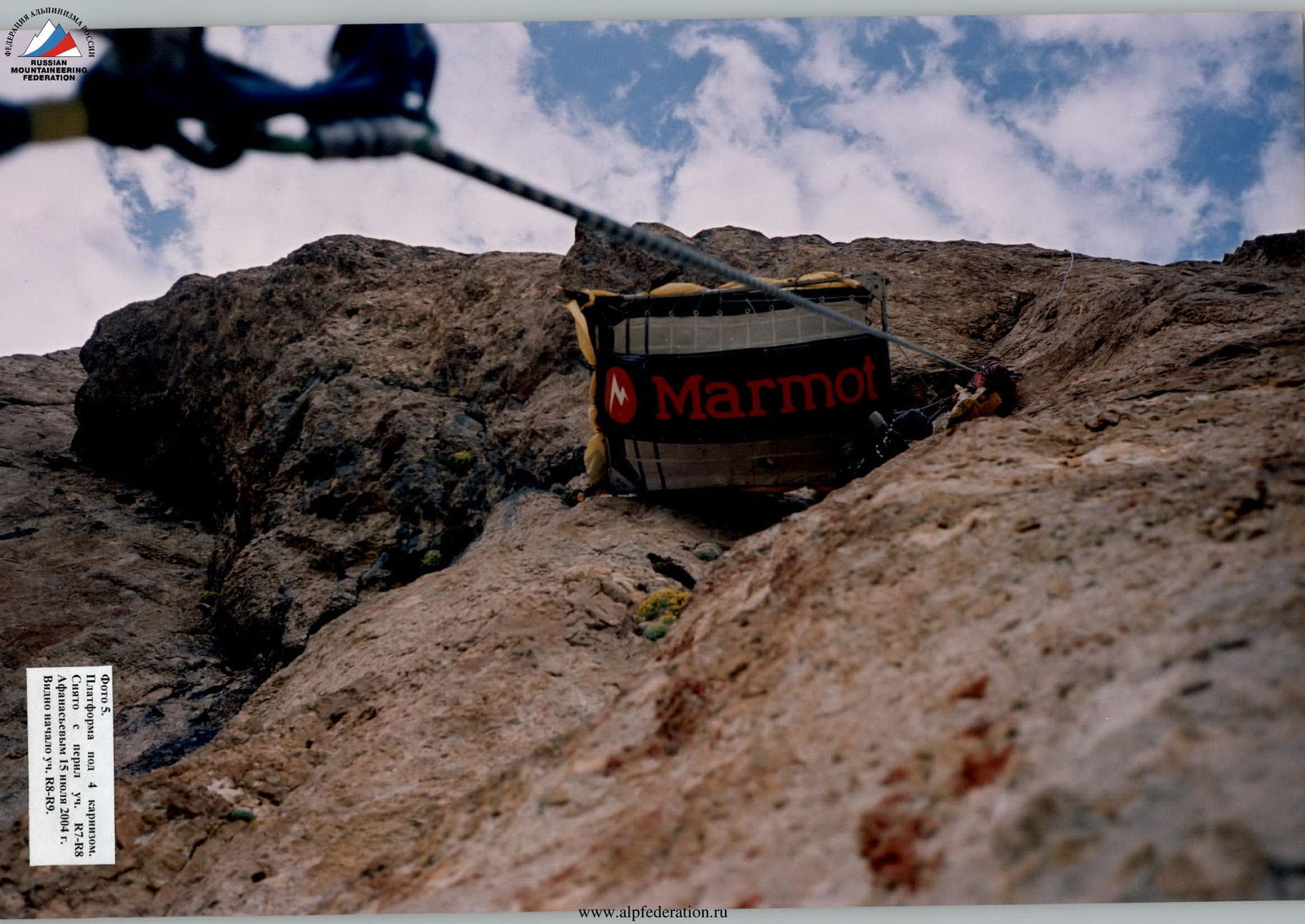
Photo 5. Platform under the 4th cornice. Taken from the belay on section R7–R8 by Afanasyev on July 15, 2004. The start of section R8–R9 is visible.
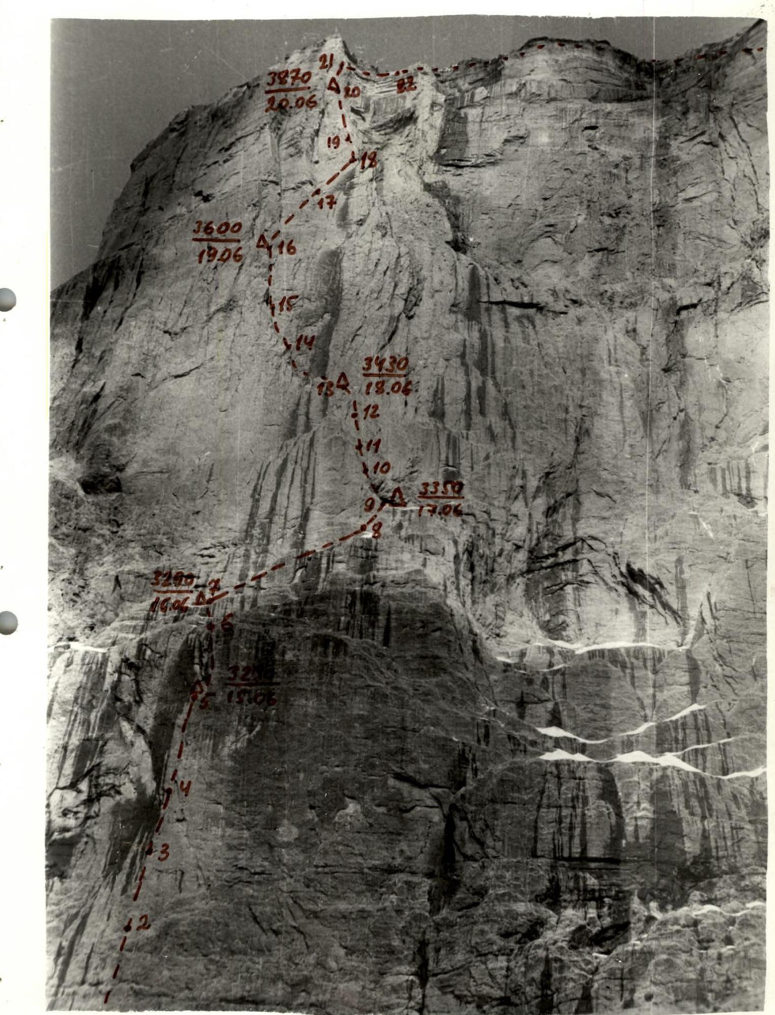 Photo 1. General view of the summit.
Sponsor: Dagestan Alpine Federation
- 367018, Makachkala, Nasrutdinova Ave., 45b, apt. 29
- Phone: +7 (8722) 65-03-28
- Leonov P.G.
Dagestan Search and Rescue Team, EMERCOM of Russia 367015, Makachkala, Erlikha St., 17, Phone: +7 (8722) 67-23-85, Murtazaliev Z.M.