56 p/p order No.498 28.10.1980 ASCENT PASSPORT
- Type of ascent — Rock climb.
- Ascent area — Eastern Caucasus, Yarydag ridge.
- Peak, its height, ascent route — Yarydag I West, 4110 m, via the right inner corner of the northwest face.
- Difficulty category — 5B–6.
- Route characteristics:
- Elevation gain — 880 m
- Average steepness of the face — 80°
- Length of sections with 5–6 difficulty category — 723 m.
- Pitons used:
| for belaying | for creating R.P.E. | |
|---|---|---|
| Ice | 0 | 0 |
| Bolt | 0 | 0 |
| Rock | 186 | 21 |
| Chocks | 44 | 3 |
-
Total climbing hours — 33.
-
Number of bivouacs and their description: 2 bivouacs. The first one after processing under the wall, lying down. The second one on a shelf in a cave, lying down.
-
Climbers' names, their sports qualification:
Feldman Gennadiy Lvovich — Candidate Master of Sports; Belousov Stanislav Vasilievich — Candidate Master of Sports.
-
Team coach — Master of Sports, Honored Coach of the Ukrainian SSR Sitsov Boris Grigorievich.
-
Start of the route — July 25, 1980.
Return — July 27, 1980.
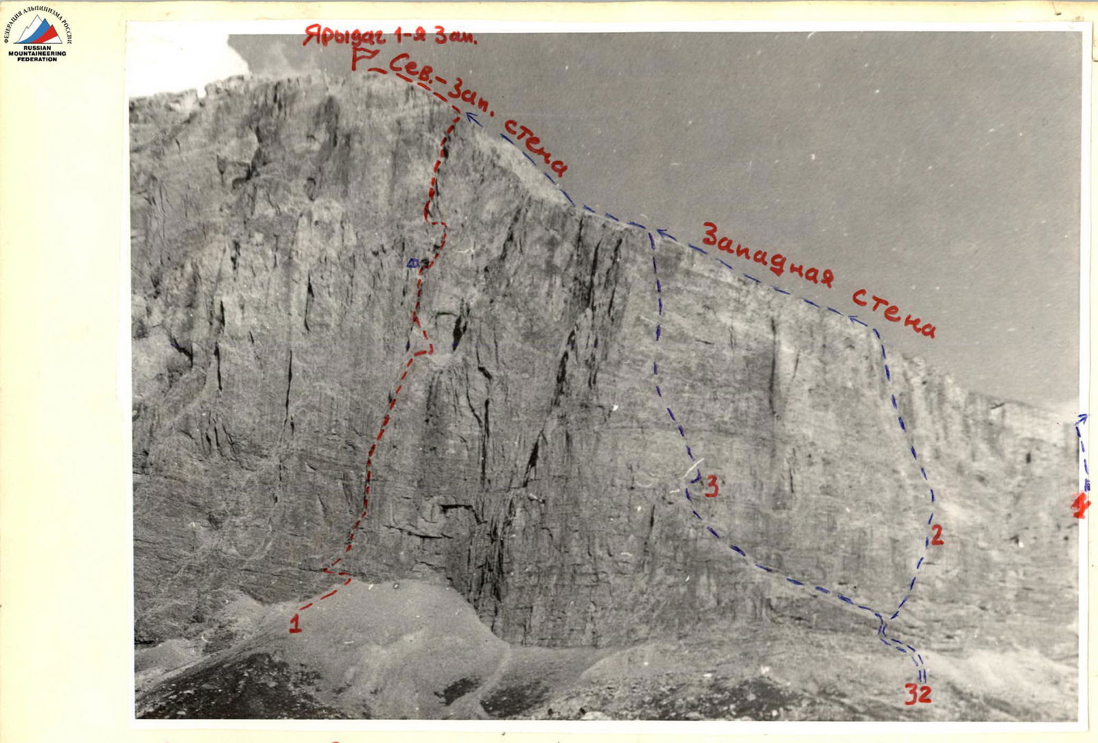
1 — ascent route
2 — Nezametnidinov's route, 5B category
3 — Polyakov's route, 5B category (first ascent), July 26–27, 1980
4 — 4B category route
Profile of the left (northeast) part of the northwest face. Taken from the ascent route. Since the northwest face is convex, the route profile can only be photographed from this (yet unclimbed) part of the face. The steepness of the left and right parts of the face is approximately the same.
Section R2–R3
Section R3–R4
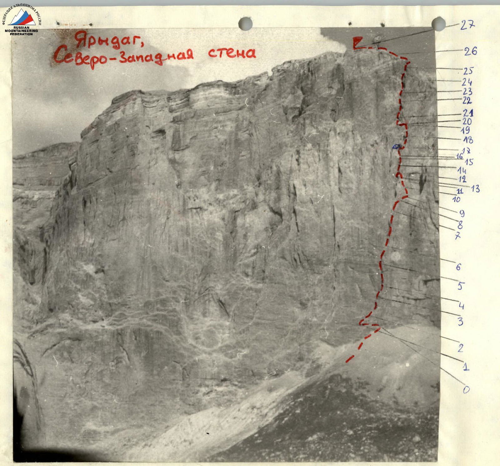
TABLE — MAIN CHARACTERISTICS — ASCENT ROUTE
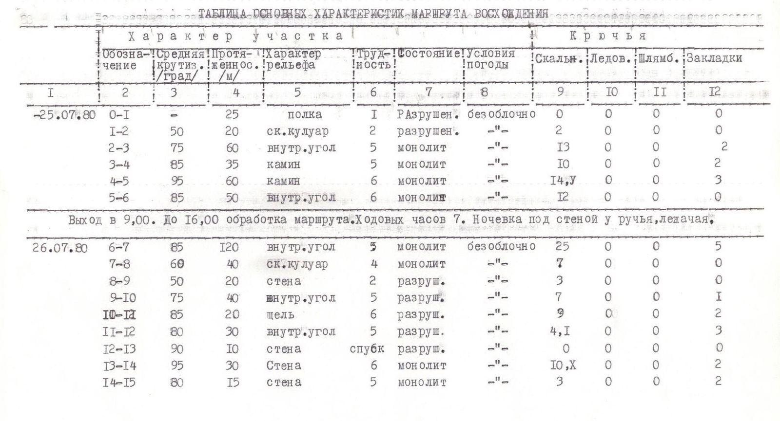
July 25, 1980
| Date | Section | Average steepness, ° | Length, m | Terrain character | Difficulty | Condition | Weather conditions | Rock pitons | Ice pitons | Bolt pitons | Chocks |
|---|---|---|---|---|---|---|---|---|---|---|---|
| 25.07.1980 | R0–R1 | 25 | shelf | 1 | broken | clear sky | 0 | 0 | 0 | 0 | |
| R1–R2 | 50 | 20 | rock couloir | 2 | broken | -"- | 2 | 0 | 0 | 0 | |
| R2–R3 | 75 | 60 | inner corner | 5 | monolith | -"- | 13 | 0 | 0 | 2 | |
| R3–R4 | 85 | 35 | chimney | 5 | monolith | -"- | 10 | 0 | 0 | 2 | |
| R4–R5 | 95 | 60 | chimney | 6 | monolith | -"- | 14 | 0 | 0 | 3 | |
| R5–R6 | 85 | 50 | inner corner | 6 | monolith | -"- | 12 | 0 | 0 | 0 |
Departure at 9:00. Route processing until 16:00. Climbing hours — 7. Overnight stay under the wall by a stream, lying down.
July 26, 1980
| Date | Section | Average steepness, ° | Length, m | Terrain character | Difficulty | Condition | Weather conditions | Rock pitons | Ice pitons | Bolt pitons | Chocks |
|---|---|---|---|---|---|---|---|---|---|---|---|
| 26.07.1980 | R6–R7 | 85 | 120 | inner corner | 5 | monolith | clear sky | 25 | 0 | 0 | 5 |
| R7–R8 | 60 | 40 | rock couloir | 4 | monolith | -"- | 7 | 0 | 0 | 0 | |
| R8–R9 | 50 | 20 | wall | 2 | broken | -"- | 3 | 0 | 0 | 0 | |
| R9–R10 | 75 | 40 | inner corner | 5 | broken | -"- | 7 | 0 | 0 | 1 | |
| R10–R11 | 85 | 20 | crack | 6 | broken | -"- | 9 | 0 | 0 | 2 | |
| R11–R12 | 80 | 30 | inner corner | 5 | broken | -"- | 4,1 | 0 | 0 | 3 | |
| R12–R13 | 90 | 10 | wall | 6 | broken | -"- | 0 | 0 | 0 | 0 | |
| R13–R14 | 95 | 30 | wall | 6 | monolith | -"- | 10 | 0 | 0 | 2 | |
| R14–R15 | 80 | 15 | wall | 5 | monolith | -"- | 3 | 0 | 0 | 2 |
July 27, 1980
| Date | Section | Average steepness, ° | Length, m | Terrain character | Difficulty | Condition | Weather conditions | Rock pitons | Ice pitons | Bolt pitons | Chocks |
|---|---|---|---|---|---|---|---|---|---|---|---|
| 27.07.1980 | R15–R16 | 110 | 8 | overhang | 6 | monolith | clear sky | 3 | 0 | 0 | 0 |
| R16–R17 | 45 | 40 | rock couloir | 2 | monolith | -"- | 5 | 0 | 0 | 0 | |
| R17–R18 | 75 | 40 | wall | 5 | broken | -"- | 8 | 0 | 0 | 0 | |
| R18–R19 | 85 | 60 | inner corner | 5 | broken | -"- | 10 | 0 | 0 | 4,1 | |
| R19–R20 | 60 | 40 | shelf | 4 | broken | -"- | 4 | 0 | 0 | 2 | |
| R20–R21 | 90 | 20 | chimney | 6 | monolith | -"- | 3,11 | 0 | 0 | 3 | |
| R21–R22 | 80 | 80 | inner corner | 5 | monolith | -"- | 10 | 0 | 0 | 7 | |
| R22–R23 | 85 | 20 | wall | 6 | monolith | -"- | 3 | 0 | 0 | 3,11 | |
| R23–R24 | 80 | 40 | inner corner | 5 | broken | -"- | 9 | 0 | 0 | 1 | |
| R24–R25 | 70 | 40 | inner corner | 4 | broken | -"- | 8 | 0 | 0 | 0 | |
| R25–R26 | 50 | 60 | ridge | 3 | broken | -"- | 2 | 0 | 0 | 2 | |
| R26–R27 | 20 | 100 | scree | 1 | fine | -"- | 0 | 0 | 0 | 0 |
Departure from the bivouac at 2:00; reaching the route at 4:00. From 4:00 to 5:30, passing the fixed ropes and then working on the route. Stopped for the night in a cave at 19:00. Lying down bivouac. Climbing hours — 13.5 hours.
Departure on the route at 4:30. Reaching the summit at 15:30. Climbing hours — 10 hours. Returned to the camp at 19:00.
Photo No.1. General photo of the summit.
Team's route:
- Polyakov's route, 5B category
- Samoded's route, 5B category
- Dubovikov's route, 5B category
control point, © bivouac location
The photo was taken on January 21, 1986, at 14:30, using Industar-104 f=2.8 lens, distance to the wall 2 km, point No.1, 2600 m.
Brief explanation of the table
Section R0–R1
Traverse left along an osypnaya shelf 1–2 m wide to a large inner corner that goes up to the right through the entire wall.
Section R1–R2
In the lower part, the inner corner is up to three meters wide. Go along the bottom.
Section R2–R3
The inner corner narrows to 1–2 m. The rocks are monolithic and smooth. Upwards along the right part of the corner towards the overhang.
Section R3–R4
The inner corner turns into a vertical chimney. Up the chimney under the overhang.
Section R4–R5
The chimney narrows to 30–50 cm and overhangs. Pitons can be driven into the wall on the left. Sometimes ladders are necessary.
Section R5–R6
The chimney flattens out and turns into an inner corner up to three meters wide. Straight up.
Section R6–R7
The inner corner branches out first into two, and then into another two inner corners. From this point, go to the right inner corner under the pronounced black streak. The rocks are monolithic but smoothed out.
Section R7–R8
The inner corner flattens out and turns into a rock couloir. Exit to a saddle between the wall and a gendarme. On the saddle is the first control point. To the right is a large osypnoy kar, dropping steeply down. From below, this kar and the wall overhanging it look like a large niche.
Section R8–R9
Under the wall, traverse right along strongly destroyed rocks under the inner corner, going left and up.
Section R9–R10
Left and up along the inner corner on the wall to a crack going right and up. To the left remains a small dome-shaped gendarme.
Section R10–R11
Along the crack right and up. The rocks are very destroyed. Go to the inner corner, going left and up.
Section R11–R12
Along the destroyed inner corner left and up under the rusty overhanging wall.
Section R12–R13
Descent by rope left and down to the black streak.
Section R13–R14
The black streak in the form of a monolithic concave wall with destroyed cracks is passed upwards along the right part. Very difficult.
Section R14–R15
The wall flattens out. Upwards under the cornice Section R15–R16
The cornice with an outreach of 1.5–2 m is passed head-on along a crack in the left part.
Section R16–R17
From the cornice up into a couloir and along it into a large black-colored cave. In the cave is the overnight stay location and the second control point.
Section R17–R18
From the right part of the cave, up and to the right along the destroyed wall to the second cave of smaller size.
Section R18–R19
The cave is bypassed on the right, from where a shelf is visible above, going left and up towards a large inner corner.
Section R19–R20
Along the shelf left and up under the inner corner overhanging in the lower part.
Section R20–R21
Along the narrowing inner corner in the form of a chimney straight up. Very difficult.
Section R21–R22
The inner corner splits. Up along it under the wall, above which the inner corner is again visible, branching into several.
Section R22–R23
Right and up along a very complex wall with breaking off holds.
Section R23–R24
Right and up along the flattening inner corner.
Section R24–R25
Up along strongly destroyed rocks to the exit to the ridge.
Section R25–R26
Having reached the ridge, turn left and go up along the destroyed rocks with a series of inner corners to the scree.
Section R26–R27
Along the scree up to the summit point.
Descent from the summit
Descent from the summit to the south, and then to the southwest, bypassing the summit tower on the left along the scree. Then along the plateau, bypass the Yarydag II West summit on the left along the scree.
The descent route:
- Descend into a rock couloir with a stream and down it.
- Further along the grassy slopes and trails, descend to Dikleriyunik.
The descent takes 3–4 hours.