Ascent Passport
-
Winter ascent category
-
Region 2.10, Caucasus, Dagestan mountains, Chekhychay gorge
-
Erydag, 3925 m, A. Nezamethinov's route (1979), via 2nd well
-
5A category of difficulty
-
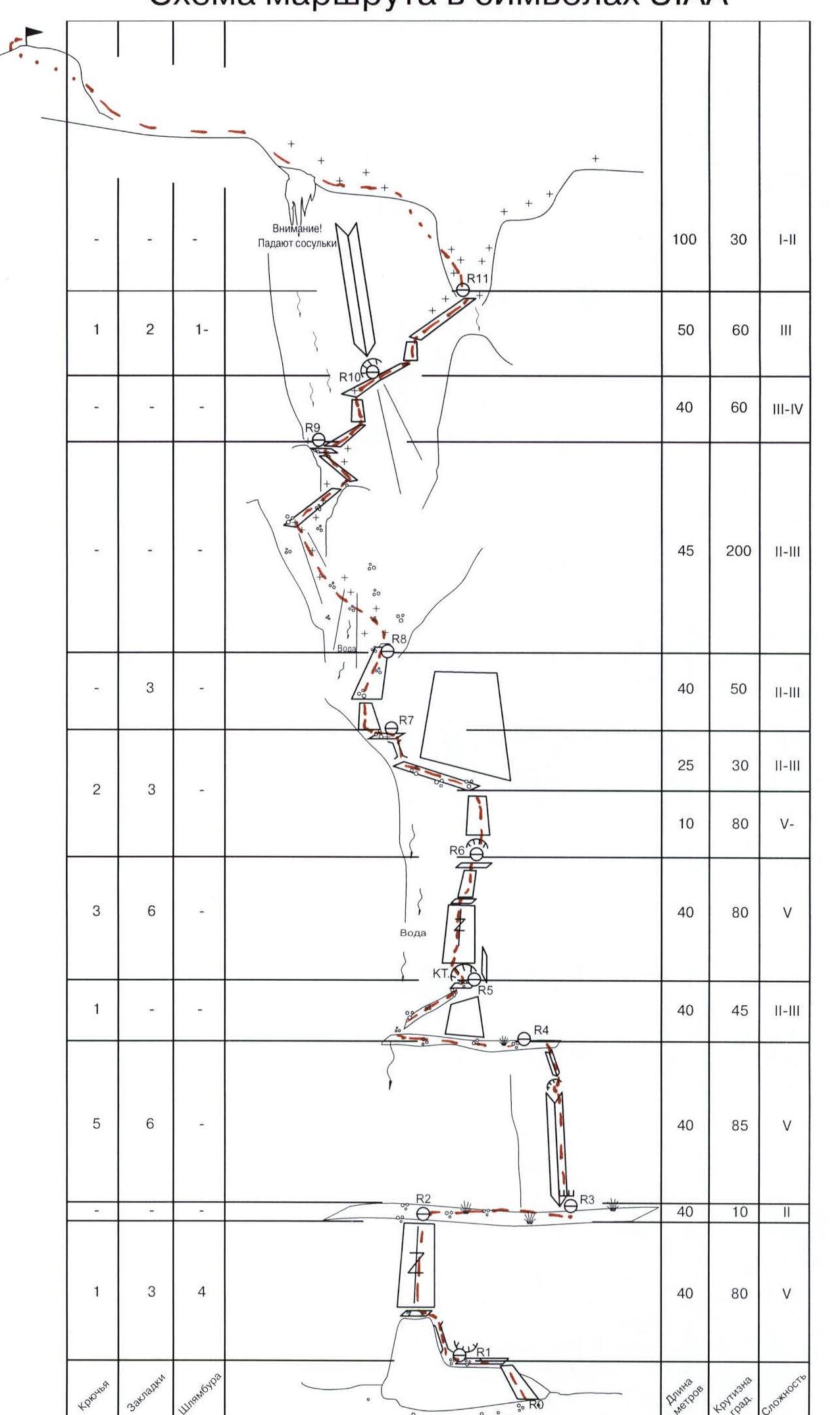
Route characteristics: height difference - 925 m, wall part - 450 m (from 3000 m to 3450 m), average steepness of the wall - 70°, route length - 2400 m, wall part - 560 m. Length of sections: 1st category of difficulty - 2000 m, 2-3 category of difficulty - 420 m, 4 category of difficulty - 40 m, 5 category of difficulty - 100 m.
-
Used on the route: rock pitons - 13, including 7 at belay stations, chocks - 23, including 8 at belay stations, bolt pitons - 4. Left behind: rock pitons - 1, chocks - 0, bolt pitons - 0.
-
Team's climbing time - 10 hours, days - 1.
-
There were no overnight stays on the route.
-
Ascent was made by a two-person team: Makin M. V. (Candidate for Master of Sports)
Tsyglin I. V. (1st sports category)
-
Coach:
Popov A. A. (Candidate for Master of Sports)
-
Approach to the route and return to the camp: February 23, 2002.
-
Organization: Alpine Federation of Rostov Region
Overview of the Ascent Area
Erydag massif is located in a short North-Eastern spur of the Main Caucasian Range, on the border between Russia and Azerbaijan; it forms almost a single plateau with Yarudag and Shagdag. In Dagestan, the walls drop 300-1100 m. The wall is composed of metamorphosed limestones. The climate is dry, but there is a lot of precipitation in May-July. In winter, there is frosty dry weather with periods of strong winds and precipitation (no more than 2-3 days).
A major problem on the wall is the lack of water, which can occur even in winter:
- snow does not stay on the wall, it is blown away;
- due to the dryness of the air, snow evaporates without melting.
Arrival to the ascent area:
- From Makhachkala along the "Caucasus" federal highway south to Novo-Gopci village (180 km);
- Then right, up the Samur river to Ushuhchai village (district center of Dokuzparinsky district) (225 km, 700 m above sea level);
- Then left along a dirt road up the Ushuhchai river to Kurush village (250 km, 2500 m).
The journey takes 6-8 hours.
Further:
- From Kurush village, descend along a trail to the confluence of the Sel'dy river into Chekhychai on the right (2250 m);
- To the right on a terrace (left bank) are the kungs of the "Erydag" base of the Dagestan Republican PSS EMERCOM of Russia (30 min.) (it is possible to drive by car);
- Then through two bridges to a terrace (right bank), along it slightly left towards the Wall, walk about 800 m, cross a stream and reach a farm;
- From the farm, slightly higher and to the right - a trail, along it move towards the Wall;
- 30-40 minutes before the Wall - camp sites (in summer there is water);
- From Erydag base camp (2750 m) - 2.5-3 hours.
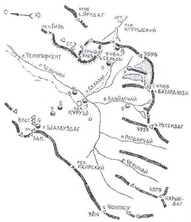
Map of Chekhychai gorge. Overnight stays:
- 1 — Kurushskie;
- 2 — Shalbuzdagskie;
- 3 — Kaspijskie;
- 4 — "Grot";
- 5 — Sel'dy;
- 6 — Erydagskie;
- 7 — "Bol'shoy Kamen'";
- 8 — Bazardyuzi;
- 9 — Vahchagskie.
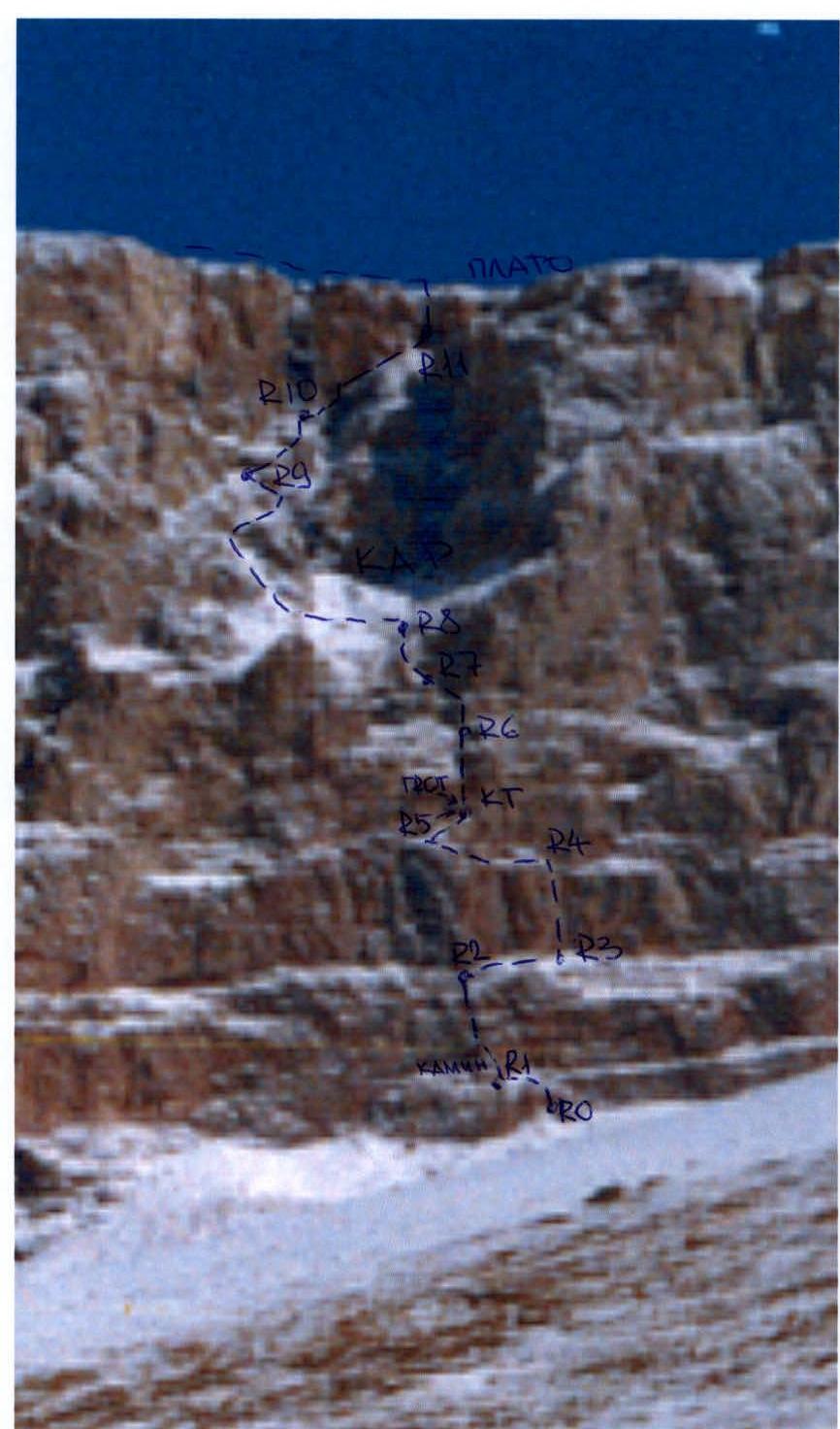
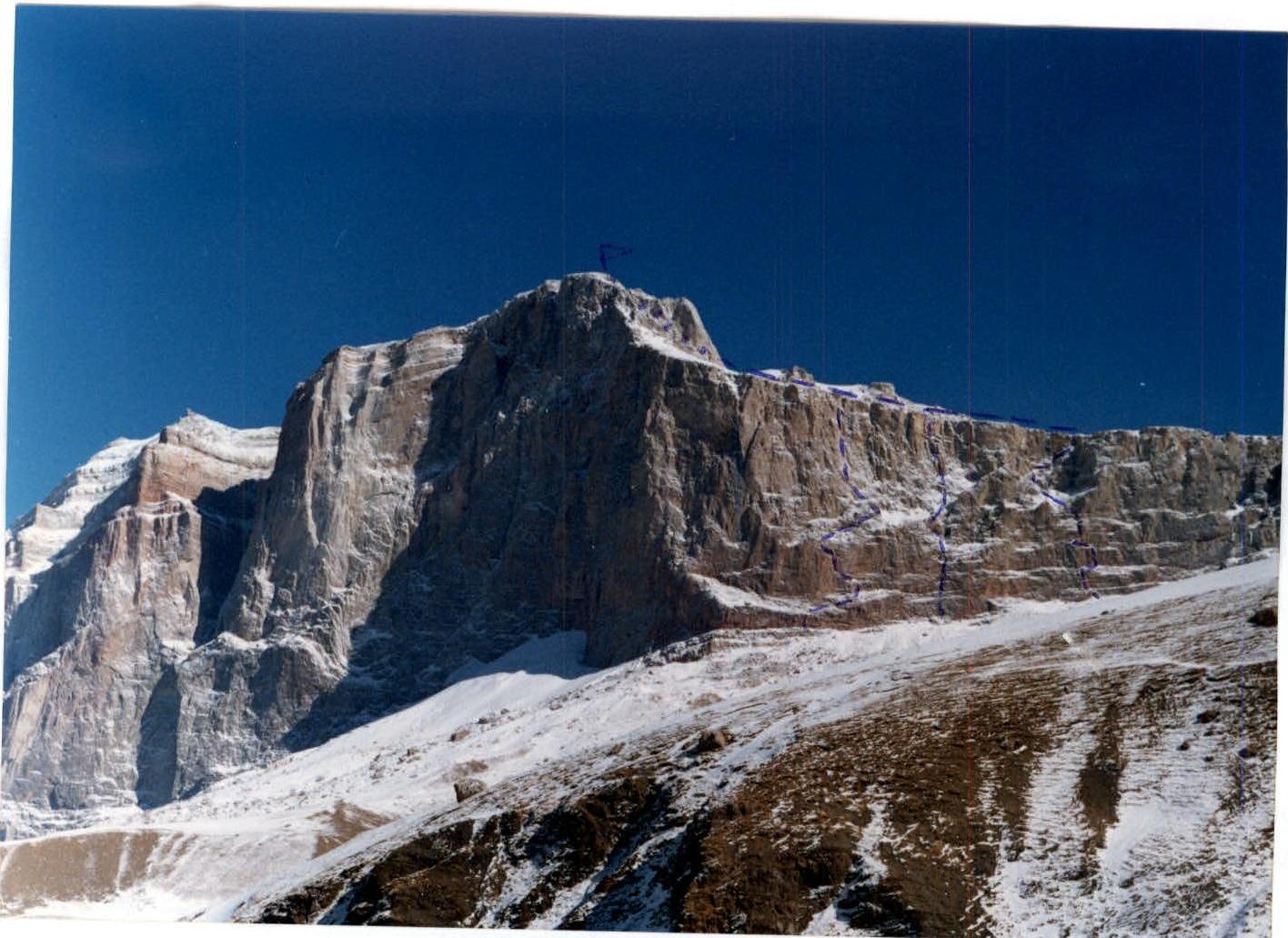
Technical photo of the route
Team's Tactical Actions
February 18, 2002. The team arrived to the ascent area.
February 19, 20. Strong wind and snowfall. We waited out the bad weather in kungs below Kurush village.
February 21. Departure for acclimatization ascent to Sel'dy peak (1B category of difficulty) and setting up a camp under the Wall. A lot of snow.
February 23. Ascent was made via A. Nezamethinov's route (5A category of difficulty). Departure at 11:00. Arrival to the plateau at 16:00. The summit was reached at 17:20. Descent was made via route 2A, Sel'dy peak. At 21:00 the group was back in the camp. The focus was on fast ascent, facilitated by the weather (frosty and clear), and the number of participants - a two-person team.
Belaying of the leader was done with a double dynamic rope ("Kaliningradka", 11 mm) paired with a static rope, used later for the second climber's ascension on jumar with a backpack. Belay stations were set up with at least 3 points, blocked by a compensation loop.
The diverse terrain on the route allowed the leader to use a wide range of technical equipment:
- chocks - hexes and friends;
- stoppers and rocks;
- titanium pitons.
Good physical and technical condition allowed the leader to climb freely, despite the low air temperature. Snow on the plateau slightly slowed down the overall ascent pace. No notes from previous participants were found on the route. The team's own notes were left on the route at control cairns, as described.
The following were taken on the ascent:
- a light tent;
- a gas burner;
- a small supply of food in case of unforeseen bad weather.
Communication with the base camp was carried out using "Lastochka" radios. During the ascent, there were no injuries, falls, or illnesses.
Route Description
The route starts to the right of the black streak descending from the middle well of the western wall. Exit to the well is made along three rock belts. A short inclined wall (R0-R1) leads to a ledge under the base of a chimney. Then, along the chimney and wall with a cleft, passable with free climbing (smoothed out), exit to a wide ledge (R1-R2).
Along the ledge, move to the right for a whole rope length, around the corner, under the base of an internal corner (R2-R3). Straight up the corner (50 m) - the key section of the route, exit to a ledge (R3-R4).
Along the ledge, move left, and then along a scree ledge to the right and up to a grotto (R4-R5). Water drips from the left. Control cairn.
From the grotto, through the left part (destroyed terrain), move straight up to a cleft. Along the cleft and a system of ledges with walls, exit to a ledge convenient for a belay station (R5-R6).
Then, moving straight up the wall, exit to a large ledge - along it as far left as possible (R6-R7).
From here, along a short wall with cracks, exit to a ridge with easy terrain, leading to a large cirque (R7-R8).
Then cross the cirque from right to left. Along a system of ledges with walls on the left side of the cirque, through a crack, exit to a plateau (R8-R10).
Then, along the plateau, left towards the summit. Bypassing the summit tower on the right along a simple scree gully, exit to the summit. Control cairn.
Descent:
- via Sel'dy peak, 1B category;
- or via 2B category.
Route map in UIAA symbols
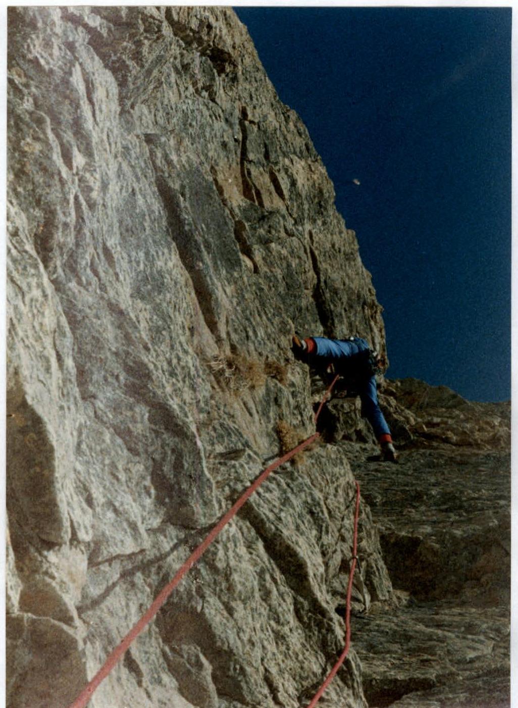
R3-R4 section of the route. Key section.
Routes:
- Nekrasova, 5B
- Dubovikova, 5A
- Nezamethinov's, 5A


