Climbing Passport
-
Climbing Category The climbing category is rock climbing.
-
Climbing Area, Ridge Eastern Caucasus. Main Caucasian Ridge.
-
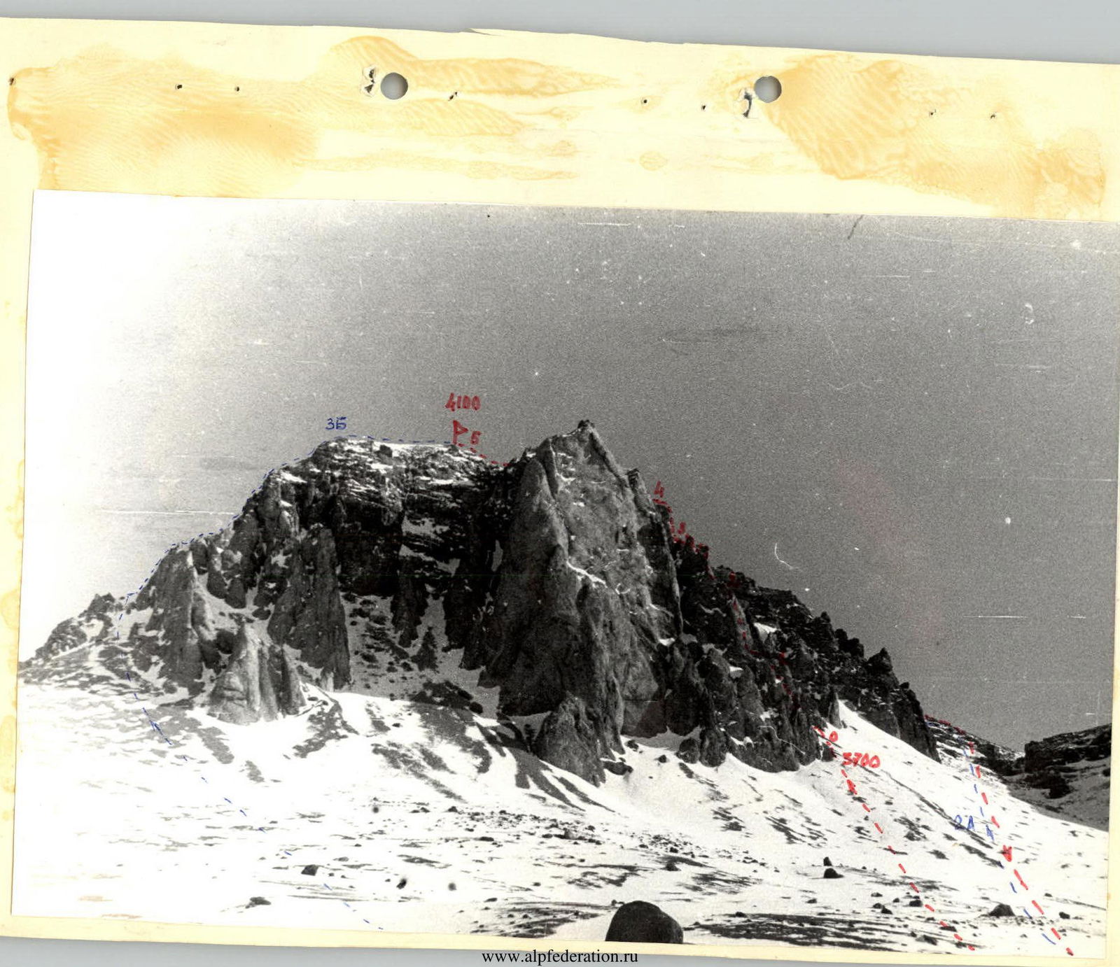
Peak, its Height, Climbing Route 1st Western Yarydag. 4100 m via the Southern ridge from the plateau.
-
Estimated Difficulty Category Difficulty category - 3B.
-
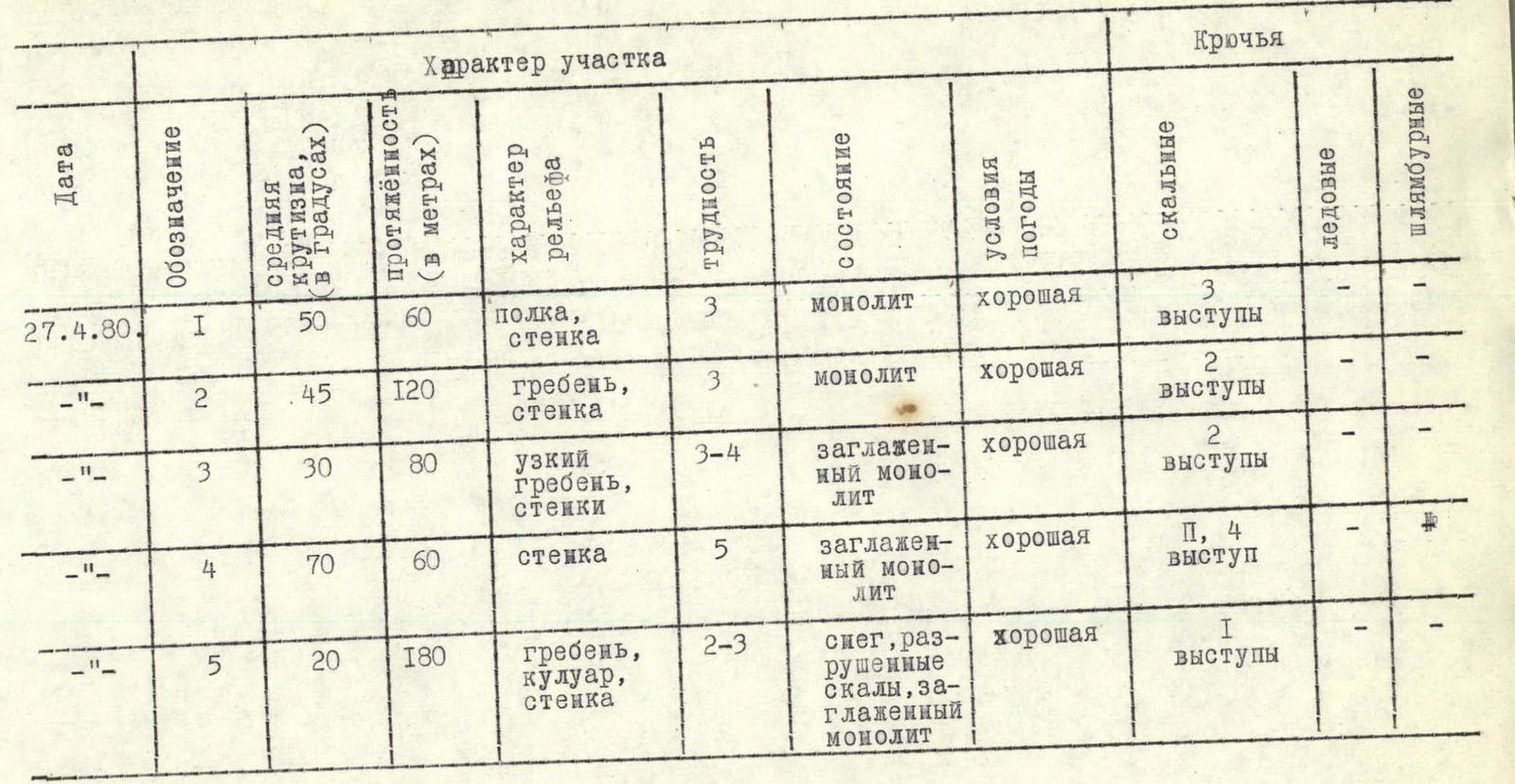
Route Characteristics height difference - 400 m; average steepness - 45°; length of sections - 5 km; trail breaking - 30 m.
-
Pitons Driven for belaying, rock pitons - 12 pcs.; for creating artificial footholds - 2 pcs.
-
Number of Climbing Hours 10.
-
Number of Overnight Stays None.
-
Full Name of the Leader, Participants, and their Qualification Tulaev I. I. - Candidate Master of Sports - leader; Kuznetsov S. I. - 1st sports category; Solovyov S. A. - 1st sports category; Mozhaev M. A. - 1st sports category.
-
Team Coach Troshchinenko L. A.
-
Date of Departure and Return departure - April 27, 1980; return - April 27, 1980.
Route Description
From the base camp located under the Western wall of Yarydag, ascend to the snowy plateau via a couloir of 2A category difficulty, following the route that leads to the 2nd Western Yarydag. Cross the plateau under the Southern ridge of the 1st Western Yarydag. The route begins with a sloping rock ledge to the left under the wall - 20 m. Up the wall - 40 m, exit onto the ridge. Piton belay. Along the narrow ridge - 80 m. Belay through outcrops. Further up the wall - 40 m. Piton belay. We emerge onto a very narrow ridge. The rocks are smoothed. Move sitting astride the ridge - 10 m. Overcome 2 walls, 5 m each, with piton belay. Further, the ridge leads to a wall - 60 m. Overcome it with piton belay, using artificial footholds. The rocks are smoothed. After the wall, along the ridge. Descent into a pass. Sport climbing - 20 m. Further along the ridge - 20 m. Control cairn. After the cairn, across the snow to the base of the couloir. The couloir is 40 m long. The rocks are heavily smoothed, traversed on tension. Exit under the "finger" - a large outcrop. Convenient for belaying. After the couloir, up and left along the destroyed wall to the pre-summit ridge. Further across snow and destroyed rocks to the summit. Descent via the couloir of the 2A category difficulty route. The route is difficult to traverse in bad weather and with icy rocks.
Map of the climbing area.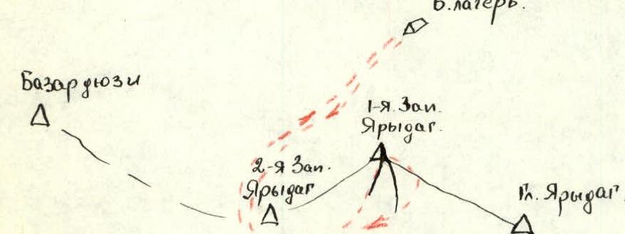 Table of main characteristics of the climbing route.