I. Winter climb.
2. Area 2.10. Dagestan mountains.
3. Dyultydag, 4127 m, via the North-Eastern counterfort, combined route.
4. Category 2A complexity, first ascent.
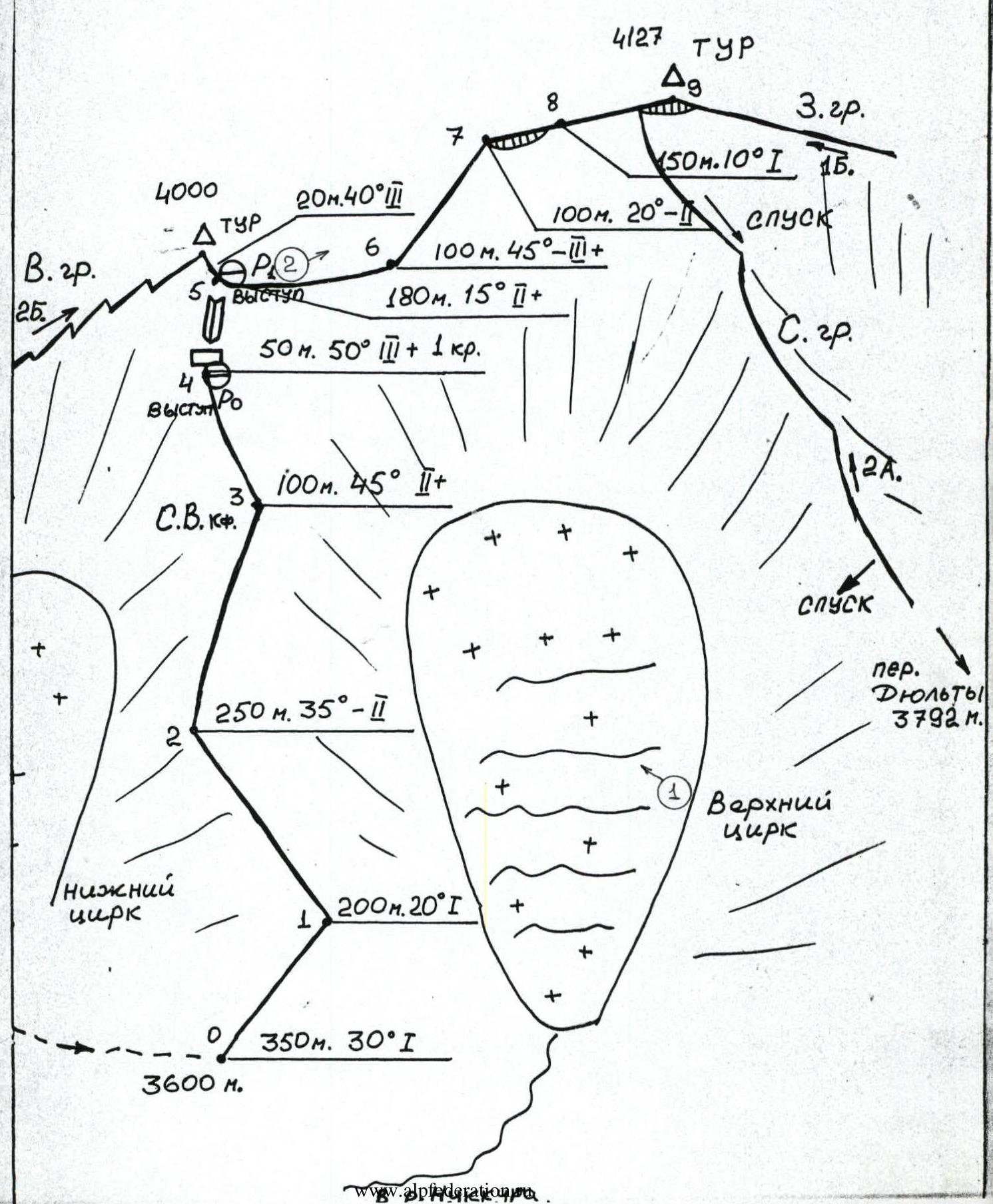
5. Elevation gain 500 m, section lengths:
1st cat. — 700 m, 2nd cat. — 630 m, 3rd cat. — 170 m, total route — 1500 m, average steepness of the counterfort — 35°.
6. Rock pitons used — 1 pc., rock outcrops — 2 pcs.
7. Climbing hours — 3.
8. No overnight stays on the route. Overnight stay in the approach camp in the North-Eastern cirque at 3500 m.
9. Participants:
Dorro Konstantin Eduardovich, CMS. Voronin Sergey Valerievich, 1st sports category.
10. Departure, summit, return on January 2, 1994.
II. Organization: Mountain club "EOS".
Makhachkala 1994 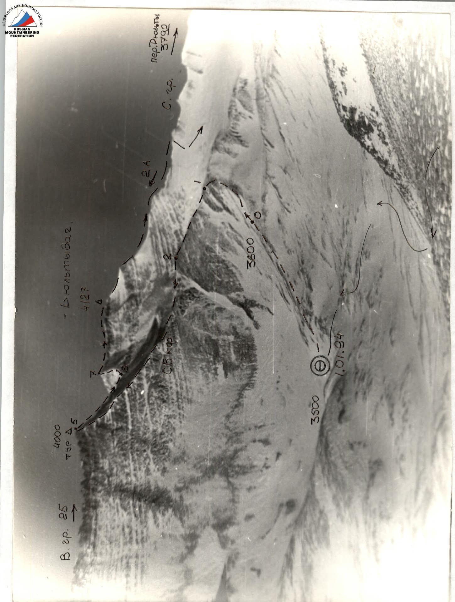
General view of the summit: Dyultydag (4127 m).
- Route 2A cat. via NE counterfort — Dorrok–94.
- 2B cat. via E ridge — Dorrok–95.
- 2A cat. via N ridge — Sayapin A. – 78.
Photo taken on January 1, 1994, 8th hour (and onwards).
Approach to the route
 From the village of Khulisma (1900 m) in the Laksky district of Dagestan, head south on a good dirt road along the left bank of the Kazikumukhskoe Koyсу river. After 7 km (2 hours), reach the Burshinsky bridge, below the confluence of the Burshi and Kazikumukhskoe Koyсу rivers (2080 m). The road turns left towards the village of Burshi. The trail continues along the left bank; in winter, there may be ice and frozen ground. The group traversed using crampons, but it's possible to bypass to the left via small bridges, although this adds 1.5 km to the route.
Follow the Kazikumukhskoe Koyсу river valley, passing three left tributaries (crossing the first bridge). After 4 hours, reach the confluence with the Nukkura river. The valley widens, and the pyramid-shaped Dyultydag comes into view at 10-3 o'clock.
Continue along the left bank of the Nukkura or through the river valley (with some obstacles) to reach the confluence with the Bodonai river on the left (2700 m) (2 hours). This is where summer herders' camps are located.
Then, follow the wide trail up the valley towards characteristic ridges (3000 m). Ascend steep grassy slopes using cairns as guides, heading towards the Dyulty pass (3792 m). Reach the scree saddle in the watershed between the streams, then descend slightly to the left into the cirque beneath the slopes of Dyultydag. Here, at the junction of the Eastern ridge and the North-Eastern counterfort, set up camp (3500 m) (5 hours from the Nukkura-Bodonai confluence).
From the campsite, ascend snowy and scree slopes to reach a scree ridge separating two cirques (upper and lower, with the upper one containing a glacier). At 3600 m, this marks the start of the route (0.5 hours from the campsite).
From the village of Khulisma (1900 m) in the Laksky district of Dagestan, head south on a good dirt road along the left bank of the Kazikumukhskoe Koyсу river. After 7 km (2 hours), reach the Burshinsky bridge, below the confluence of the Burshi and Kazikumukhskoe Koyсу rivers (2080 m). The road turns left towards the village of Burshi. The trail continues along the left bank; in winter, there may be ice and frozen ground. The group traversed using crampons, but it's possible to bypass to the left via small bridges, although this adds 1.5 km to the route.
Follow the Kazikumukhskoe Koyсу river valley, passing three left tributaries (crossing the first bridge). After 4 hours, reach the confluence with the Nukkura river. The valley widens, and the pyramid-shaped Dyultydag comes into view at 10-3 o'clock.
Continue along the left bank of the Nukkura or through the river valley (with some obstacles) to reach the confluence with the Bodonai river on the left (2700 m) (2 hours). This is where summer herders' camps are located.
Then, follow the wide trail up the valley towards characteristic ridges (3000 m). Ascend steep grassy slopes using cairns as guides, heading towards the Dyulty pass (3792 m). Reach the scree saddle in the watershed between the streams, then descend slightly to the left into the cirque beneath the slopes of Dyultydag. Here, at the junction of the Eastern ridge and the North-Eastern counterfort, set up camp (3500 m) (5 hours from the Nukkura-Bodonai confluence).
From the campsite, ascend snowy and scree slopes to reach a scree ridge separating two cirques (upper and lower, with the upper one containing a glacier). At 3600 m, this marks the start of the route (0.5 hours from the campsite).
Route description
From the start of the North-Eastern counterfort (3500 m), traverse left along its ridge. There are occasional outcrops of broken slate rocks forming steps. Before reaching the Eastern ridge, the slope becomes steeper. A short wall precedes a belay anchor (R0); an internal corner transitioning into a chimney leads to the Eastern ridge. Here, place another belay anchor (R1), and 20 m to the left, on a sharp shoulder of the Eastern ridge (4000 m), there is a cairn. From R1, follow the sharp Eastern ridge towards its rise, where the snow is hard and icy (use crampons!). There are rock outcrops along the way. As you approach the pre-summit slope (4100 m), beware of potential cornices. Before the slope, there's a sharp rocky ridge and slabs. Ascend the scree slope to reach the summit. Cairn (4127 m, 3 hours). Descend via the Northern ridge, following route 2A. From the summit, be cautious of potential cornices. On the ridge, the snow is hard due to wind, and there are rocky steps. Before reaching the "Golub" gendarme:
- Turn right and descend;
- Reach the camp in the upper cirque of the glacier. Features:
- In summer, there may be crevasses;
- Descent takes 1 hour.
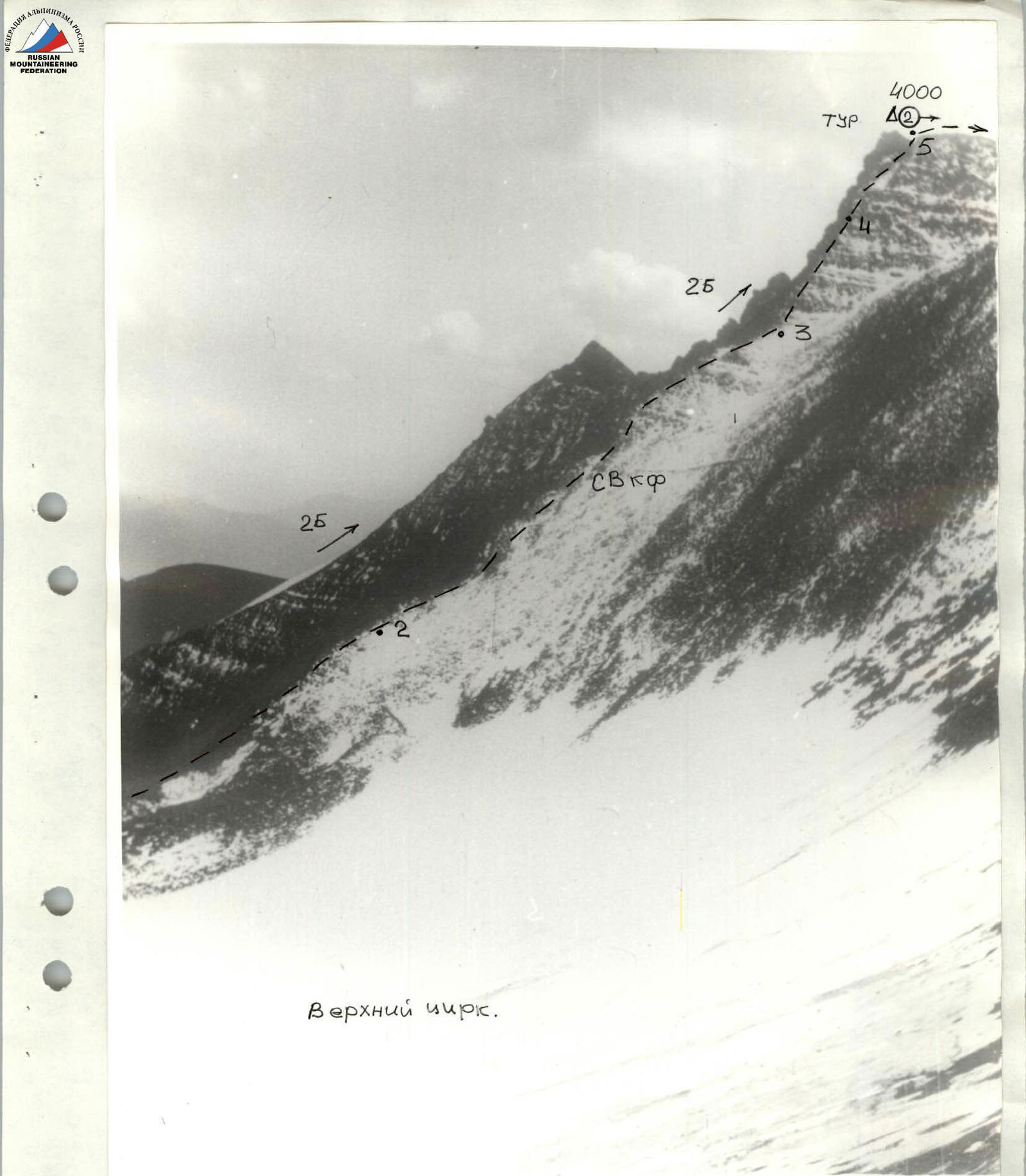
Photo 1. NE counterfort, sections R2–R5. 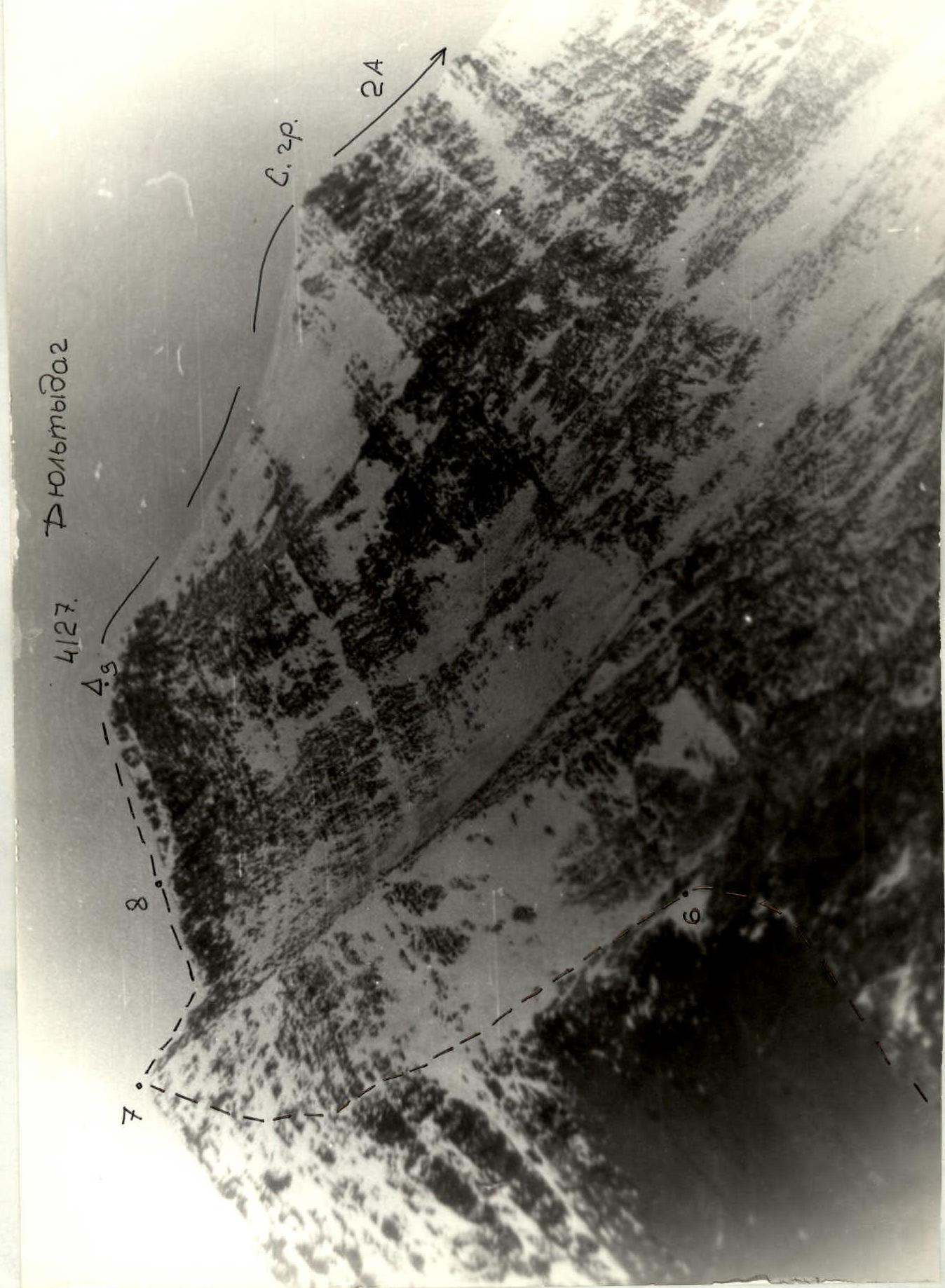 Photo 2. Pre-summit ridge. Sections R6–R9. Taken from R1.