I. Climbing area 2. Climbing category 3. Peak, its elevation 4. Ascent route 5. Estimated difficulty category 6. Route description
-
Number of pitons used
-
Number of bivouacs and their description
-
Number of travel hours
-
Surname, I.O. of team leader and participants, their sports qualification
II. Date of ascent 12. Team coach
Note: Note by Gazimagomedov M. and Surkhaev O. dated September 7, 1973, has been removed.
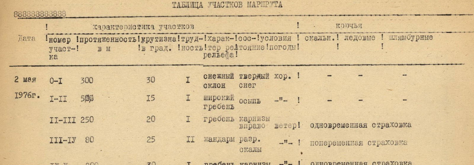
2.9. East Caucasus - combined Dartsа (3906) via south ridge 1B Elevation gain – 700 m; section lengths:
- 0–I – 300 m
- I–II – 500 m
- II–III – 250 m
- III–IV – 80 m
- IV–V – 200 m Average slope – 25°. Not used. Overnight stay in the base camp near Dartsа farm 8–9 Timoshin M.E. MS Akhmedkhanov K.E. II Pashuk E.G. III Kozorezov E.F. — Leonov P.G. — Yakhyaev R.K. — Moiseev S.I. ZN Nikomagomedov Z. — Leshchenko V.I. — Dolgikh E.A. — Semenova O.M. — Arslanbekov A. — May 2, 1976 MS Timoshin M.E.
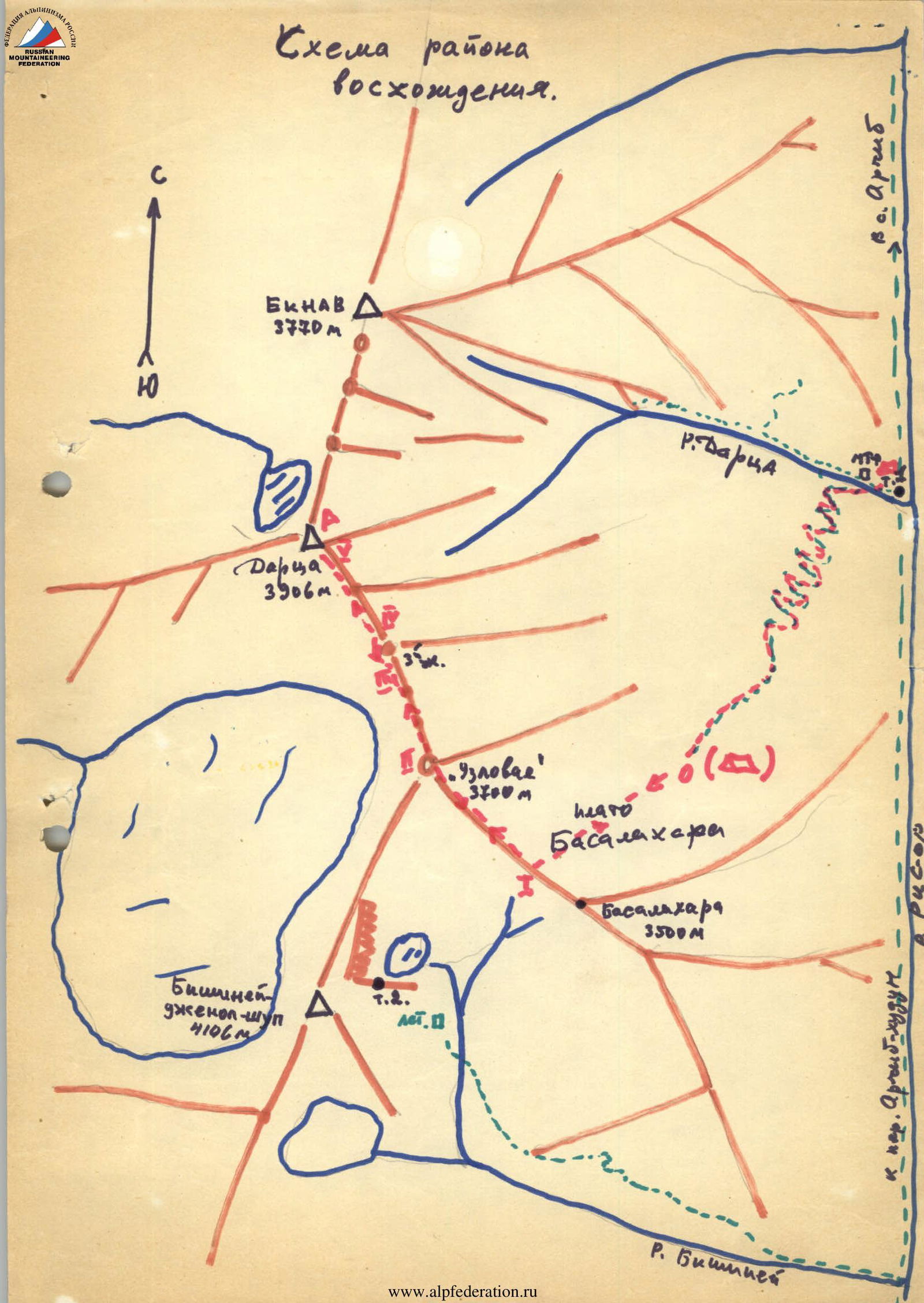
 — Base camp
... Ascent and descent path
1-1- Route sections
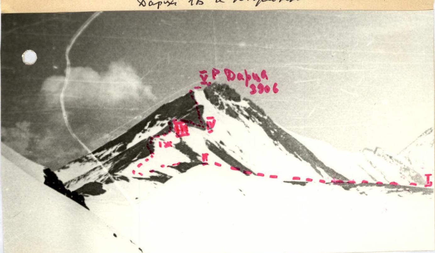
View of Dartsа peak from the Ris-or river valley (from the east, on diagram T. 1)
— Base camp
... Ascent and descent path
1-1- Route sections
View of Dartsа peak from the Ris-or river valley (from the east, on diagram T. 1)
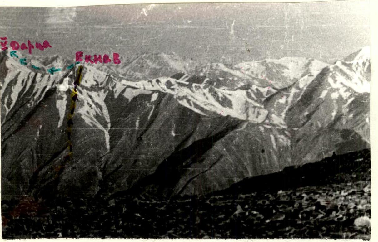
View of Dartsа peak (3906 m) from pass 3900 (Shalshibsky khutor, area of p. 4049). Photo taken in May 1978.
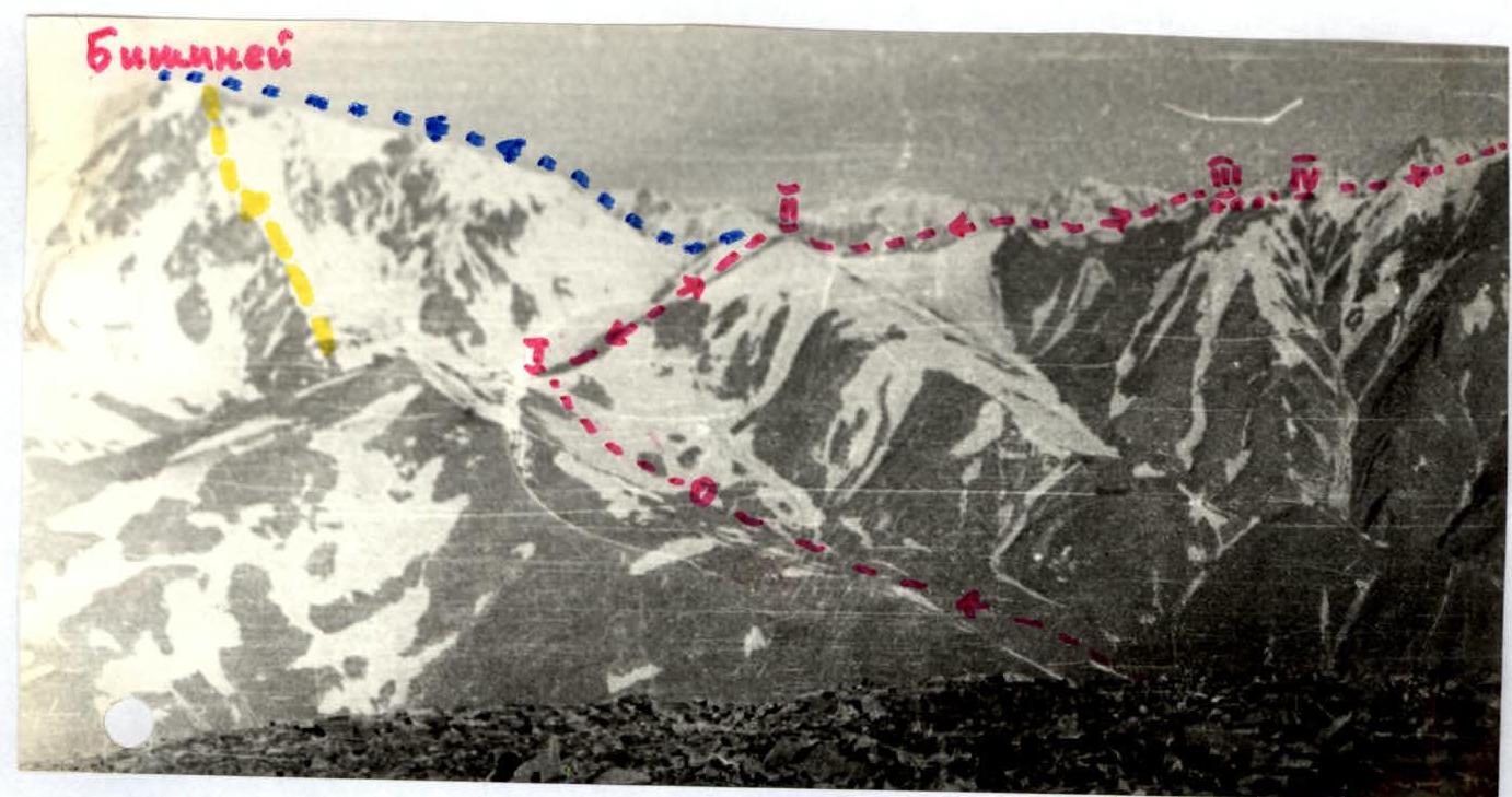
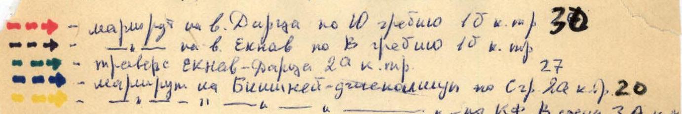
— Route to Dartsа peak via S ridge 1B. 30.
— to Eknav peak via E ridge 1B.
— Traverse Eknav–Dartsа 2A cat. diff.
— Route to Bishinei-draskalimaya via N ridge 2A cat. diff. 20.
— 71 Kr. V. wall 3A cat. diff. 217.
Dartsа 1B via S ridge.
Approach description
The base camp for ascending Dartsа peak, Bishinei (2A cat. diff. via N ridge) and traverse Eknav–Dartsа (2A cat. diff.) is set up at the mouth of the Dartsа river on a wide grassy clearing, 100–150 m above the confluence of the Dartsа river with the Ris-or river. From Archib village, take the road to Alchunib village and then follow a well-trodden path to Kubatl khutor. From there, follow the left bank of the river on a frequently disappearing path, traversing scree slopes, to the wide gentle outwash of the Dartsа river and up it to the clearing. From Archib village, it takes 3–3.5 hours. From the camp on the left bank of the Dartsа river valley, go up the valley on a path and cross to the right bank opposite a stream flowing into the river through a deep canyon. Then, follow the path to climb to the Basalakharа plateau (1 hour from the camp). The path winds up a steep grassy slope (up to 60°). Upon reaching the plateau, walk with a slight elevation gain southwards to the saddle on the ridge connecting Basalakharа peak (3500 m) and "Uzlovaya" peak (3700 m).
Route description
Climb to the saddle on steep snow (1 hour from the edge of the plateau), then follow the gentle ridge westwards to Uzlovaya peak (1 hour from the saddle). From Uzlovaya, descend to the N. Bishinei pass (3650 m) and move north along the slate ridge with five uncomplicated gendarmes (Cornices!), bypassed on the left on snowy shelves or on uncomplicated but heavily destroyed rocks with sandstone outcrops. When bypassing the third gendarme, alternating belay is necessary on its western slope and when exiting to the saddle with a cornice overhanging to the east. Further, with simultaneous belay, exit to the summit on steep stony scree. A cairn is on the summit. From "Uzlovaya" 1 hour 20 minutes. Descent via the ascent route takes 3 hours.
Recommendations
Departure from the camp in the Dartsа valley at 4:00 am. Group size 10–20 people. Standard equipment.
Route sections table
| Date | section number | length, m | slope, in degrees | difficulty | terrain type, weather conditions | rock | ice | bolted |
|---|---|---|---|---|---|---|---|---|
| May 2, 1976 | 0–I | 300 | 30 | I | snow, firm, good, slope snow | - | - | - |
| I–II | 50 | 15 | I | wide, scree, ridge | - | - | - | |
| II–III | 250 | 20 | I | ridge, cornices, right, wind, simultaneous belay | - | - | - | |
| III–IV | 80 | 25 | II | gendarme, destroyed rock, alternating belay | - | - | - | |
| IV–V | 200 | 30 | I | ridge, cornices, simultaneous belay | - | - | - |
 Climbing area diagram.