I. Category of first ascents. 2. Region 2.10, Dagestan Mountains, Bogossky Ridge. 3. Addalashukhgelmeer, 415 m, via the right gully of the North-East face, combined route. 4. Proposed category 3B, first ascent. 5. Height difference 700 m, route length: category 1 - 450 m, category 2 - 450 m, category 3 - 120 m, category 4 - 195 m, category 5 - 15 m, total route length 1220 m, average slope of the gully 45°. 6. Pitons used: rock - 6 pcs, ice screws - 17 pcs. 7. Climbing time - 7 hours. 8. No overnight stays. Overnight stay at the base camp, at TDS "Sulak-Vysokogornaya" (2953 m). 9. Leader: Dorro Konstantin Eduardovich, Candidate for Master of Sports. Team members: Ivanov Alexander Petrovich, 2nd sports category; Maximov Vladimir Vladimirovich, 2nd sports category; Fomin German Vladimirovich, 2nd sports category. 10. Departure, ascent, and return - August 1, 1992. 11. Organized by: Mountain clubs "Eos" and "Bogos".
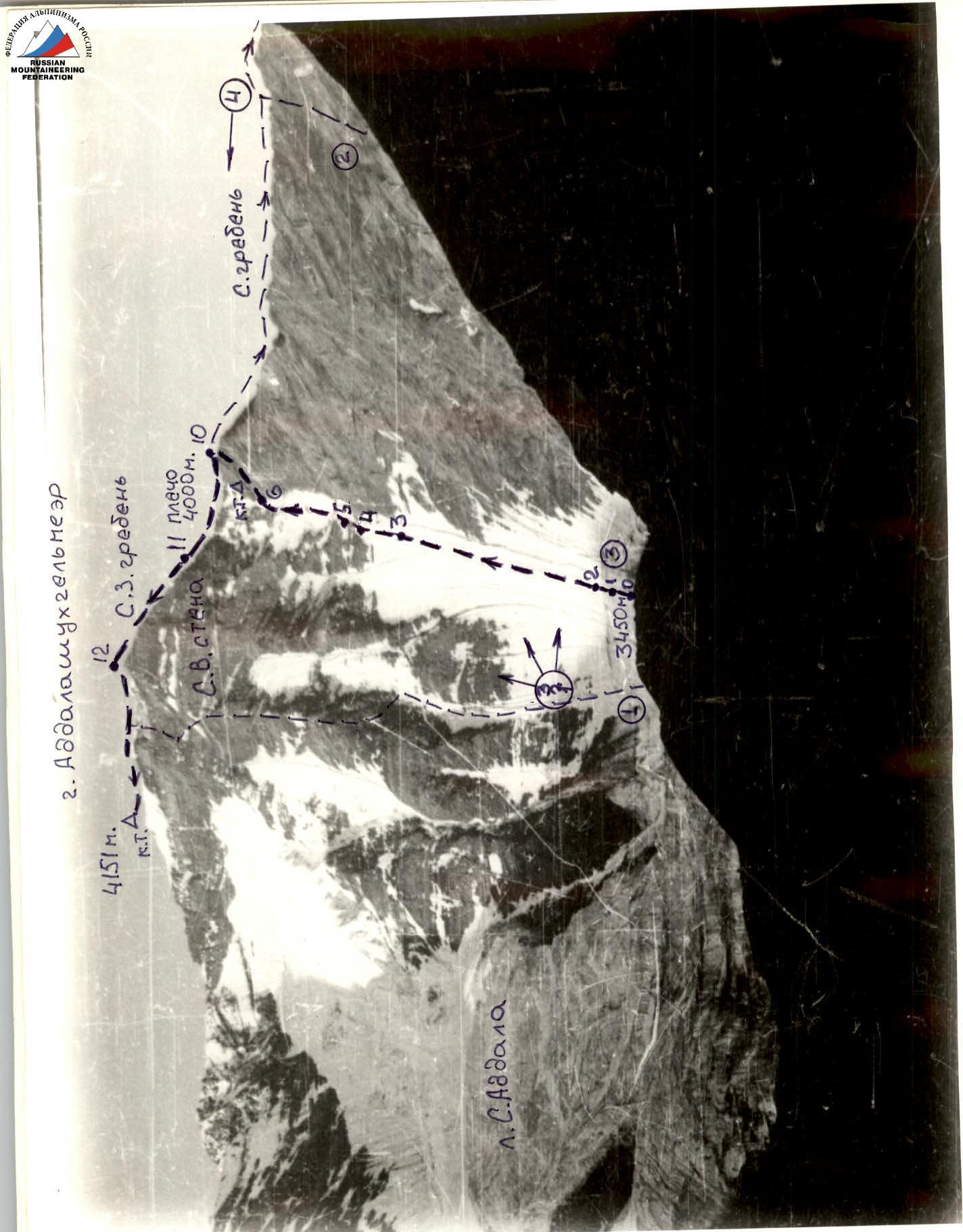
Photo 0 - General view of Addalashukhgelmeer peak from the North. (1) Route via the central buttress of the NE face, category 4B, combined, Yu. Krasnopolsky 1984. (2) Route via the N ridge, category 2B, rock, Sh. Shanazazov 1986. (3) First ascent route: via the right gully of the NE face, category 3B, combined, K. Dorro 1992. Photo taken in August 1985, point "0" on the area map. Time of shooting 8:00, from a height of 2953 m, Smena-Symbol, distance ≈ 3.5 km. (4) Shooting point and photo number - Mt. Addalashukhgelmeer.

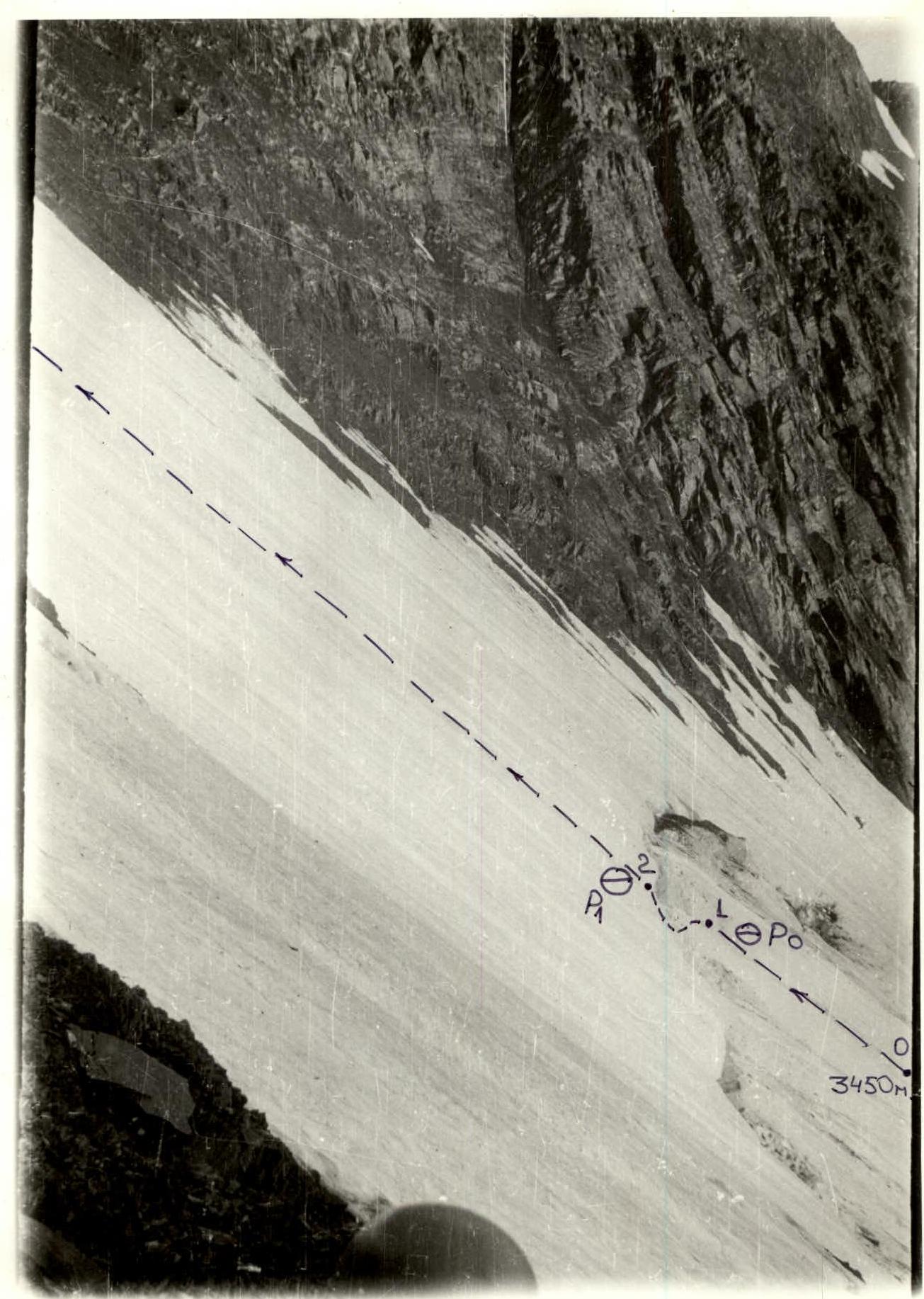
Photo 1: Lower part of the gully, bergschrund, R0 and R1, sections R0-R2. Photo taken in February 1985.
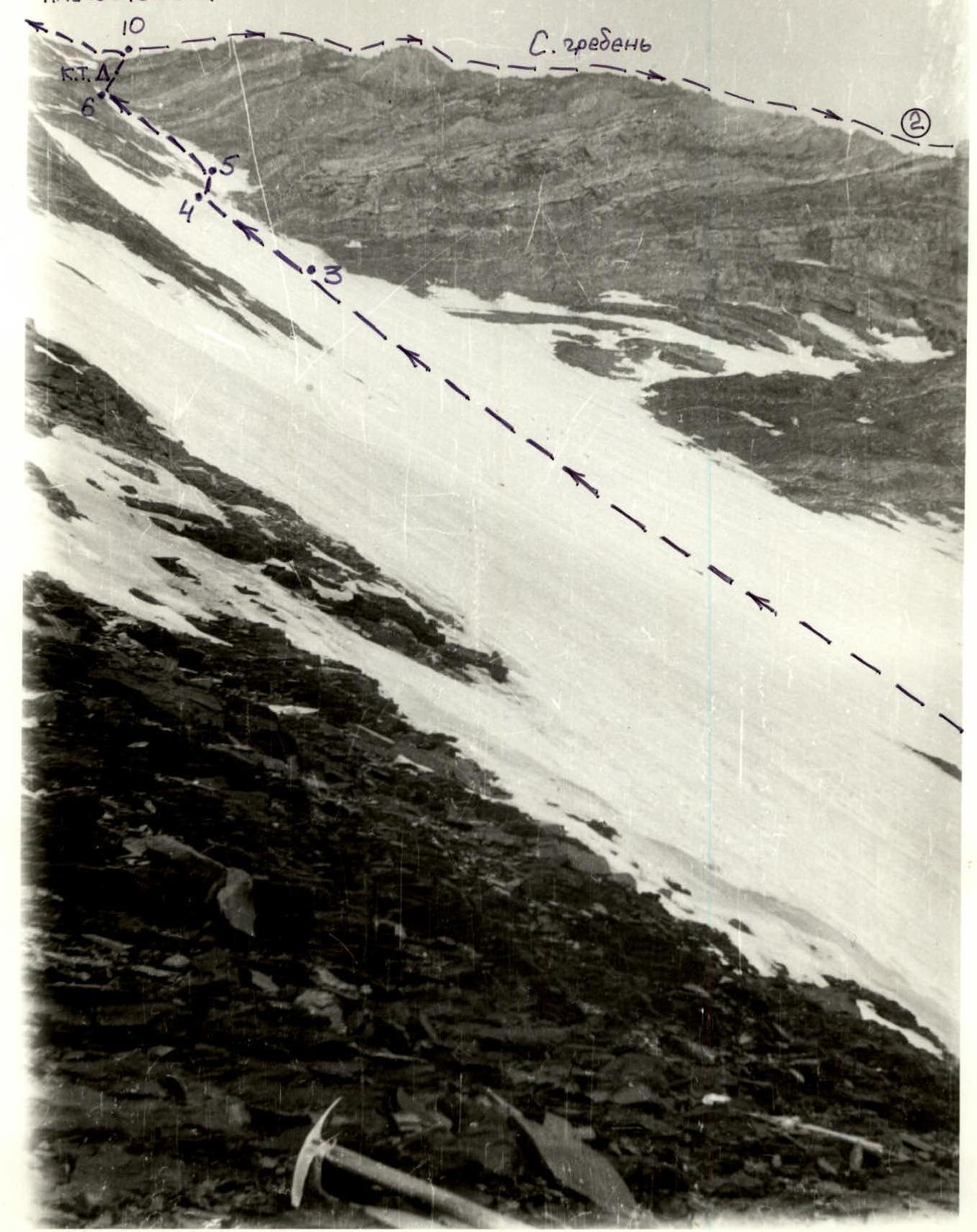
Photo 2: Sections R2-R10. Photo taken in August 1985.
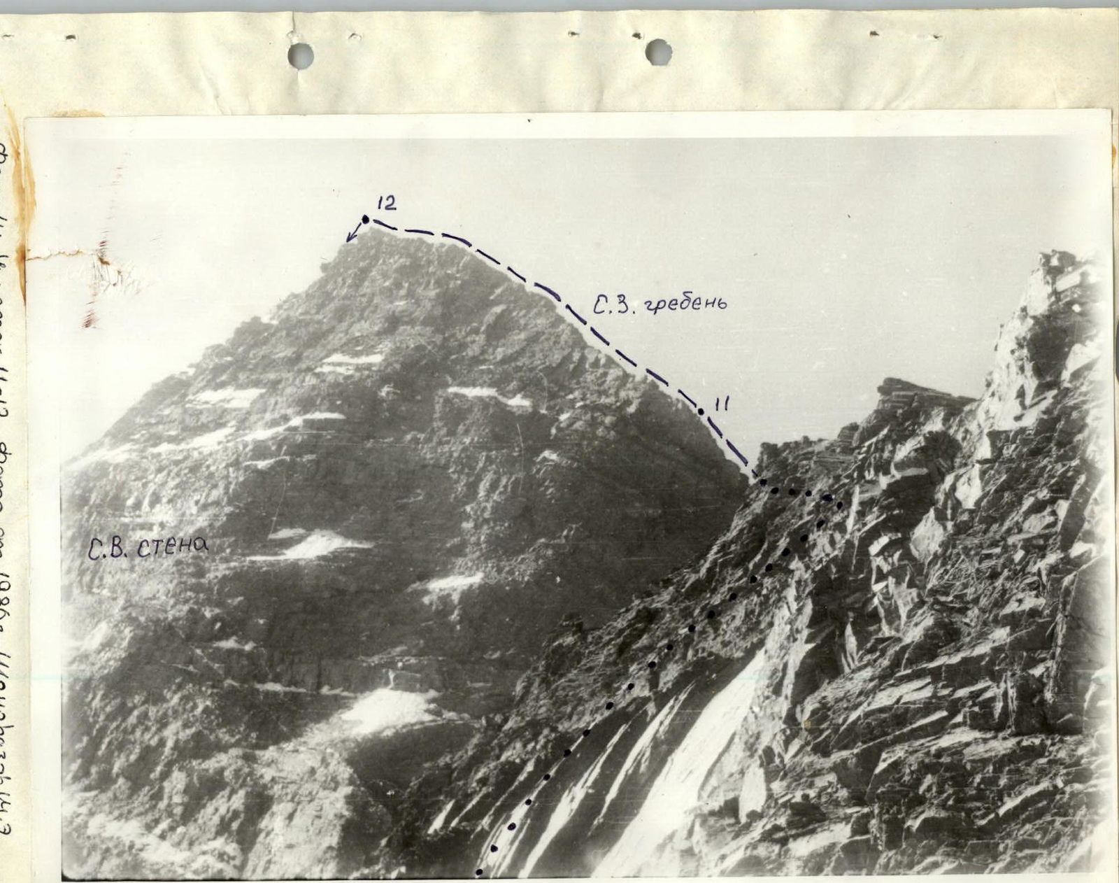

Photo 3: Sections R3-R12. Photo taken in August 1985. From the CobeGODARI farmstead (2000 m), TsUMADINSKY district of the Republic of Dagestan, cross the r. Kila via the footbridge, and move to the high grassy cape - the end of the N spur of Mt. Addalashukhgelmeer.
Follow the trail to the left, through the birch forest. Kila remains far below. Do not deviate to the left branches of the trail - they lead down to the descents to the river, and some get lost on the conglomerate slopes.
To the right, a steep ascent to a grassy spur is visible. Follow the trail onto it, then less steeply. The trail goes through rhododendron thickets. Ahead, on the cape, a weather station is visible.
The trail goes along the NE slopes of the N spur, crossing several avalanche gullies, and leads to a hollow, then to TDS "Sulak-Vysokogornaya" (2953 m). The base camp is here (from the CobeGODARI farmstead - 3 hours 30 minutes).
This path is used in summer and is passable for pack animals. However, in winter, the trail is prone to avalanches. You should use the trail that runs along the right (sunlit) bank of the Kila, and ascend to the weather station after crossing the Kila via a rocky ridge that forms the cape where the weather station is located (a cable is stretched along the ridge).
From the weather station, move along the left-bank moraine of the North Addala glacier, then descend onto the glacier and, keeping to the left side (crampons, rope), below the E slopes of the N ridge, to the right of the icefall, and reach the upper ice plateau (closed crevasses). Across the plateau to the left, below the right snow-ice gully of the NE face of Mt. Addalashukhgelmeer. Here begins the route (3450 m). From the weather station - 2 hours.
The route starts from the upper ice plateau of the North Addala glacier and goes via the right gully of the NE face. The lower part of the gully is wide, and the steepness increases gradually (section R0-R1). The entire slope is cut by a wide bergschrund (section R1-R2), in front of R0. The height of the upper edge is over 7 m in some places. The bergschrund should be traversed where it is cut by a gully (depth by the end of summer - up to 2 m). At the bottom of the bergschrund, there is a snow-ice plug. Be cautious of falling rocks (with the first sun rays), and R1 should be traversed by moving away from the gully onto the firn of the gully. Further up the gully (section R2-R3), move straight up towards the visible narrowing, to a rock step. On this section, the group moved simultaneously, but when crossing the gullies, they used ice axe belays (in the gullies - water). Before the rock step, the steepness increases, with a thin layer of firn on top of ice; belays via ice screws (sections R3-R4, R2, and R3). The rock step (section R4-R5) is complex to traverse (ice formations, water, crampons required). Further up the upper part of the gully (section R5-R6), stay on the axis; towards the edges, there are voids and thin ice sections (belay points R4-R8). To the right, a shoulder is visible - the junction of the N and NW ridges. When approaching the shoulder, moving straight up becomes problematic (ice is thin, ice screws do not hold, and rocks are heavily destroyed, piton belays are unreliable). The group deviated to the right onto the slabs (section R6-R7) and then via a ledge and an inner corner (section R7-R9) reached the N ridge 25 m from the shoulder. The ascent up the ridge (section R9-R10): bypass to the right and in a helical trajectory, exit onto a horizontal shoulder (4000 m). From the shoulder, up the NW ridge and through an ascent (section R11-R12, a series of ledges and 2-3 m walls). The ridge becomes much gentler, and with a slight gain in height (some places have cornices to the left), reach the summit. Cairn. From the start of the route - 7 hours. The group descended from the summit along the N ridge until it became gentler, and then along the N spur to the first rock peak (standing above the weather station, 3600 m). About 1.5 km. From the summit:
- Move to the right onto the slope, to the main terrace.
- Move along the terrace to the right - down (do not deviate to the left - it is a drop).
- Descend onto the North Addala glacier.
- Further along the glacier and moraine (following the ascent path) to TDS.
Note: When traversing the route, groups should plan an early start. The gully is prone to rockfall, especially by the end of summer. The mountain is composed of slate schist with sandstone layers, to which the steepest sections are related, as they are less prone to weathering. It is advisable to have several "carrot" pitons for the rocks in the upper part of the gully. The group completed the route and returned to the camp in 12 hours. On R9, there is a cairn and a note in a can on a piton.