
- Climbing category — technically challenging.
- Area 2.9 (from the Perevalny Krepost to the village of Pan); Chauhi mountain range.
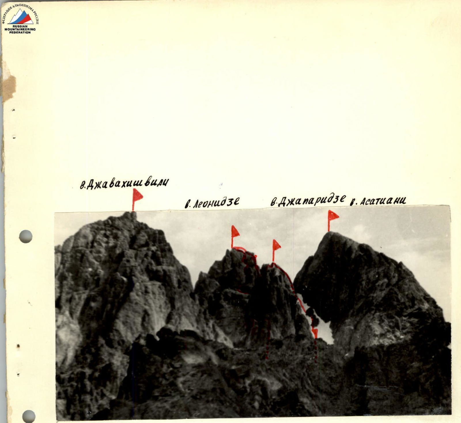
- Traverse of peaks Leonidze (3773 m) — Japaridze (3733 m) with ascent via the South-West edge of peak Leonidze.
- Proposed difficulty category — 4A.
- Route characteristics:
height difference — 350 m; average steepness of the edge on ascent — 60°; length of sections with 5th cat. diff. totals — 60 m.
- Only rock pitons were used during the ascent along the edge. A total of 34 pitons were hammered in. 3 of them were used to create artificial footholds (ladders).
- To complete the route from the base camp near three stones and back, 13.5 hours were spent in good weather conditions. Of these:
- approach to the route — 2.5 hours;
- ascent along the D-3 edge of peak Leonidze — 6 hours;
- traverse of two peaks — 3 hours;
- descent from peak Japaridze and return to base camp — 2 hours.
- There were no overnight stays on the route.
- Group composition:
1962471-9 Kubinsha 58-35 Svistun Sergey Semyonovich
- team leader; 1st sports category; Mityukhin Fyodor Petrovich
- 1st sports category; Babushkin Oleg Anatolyevich
- 1st sports category; Vishchenko Khariton Nikolayevich
- Candidate for Master of Sports; Babai Olga Nikolayevna
- 1st sports category.
- Team coach — Krivov Vasily Nikolayevich, Candidate for Master of Sports.
- Ascent completed on July 29, 1980
- first ascent route
- traverse route of Chauhi massif (5B cat. diff.)
- ascent route to peak Japaridze (3A cat. diff.)
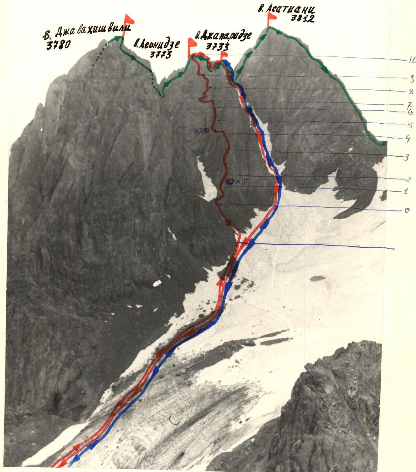
Panorama of Chauhi massif in the area of the first ascent route
Map-scheme of the ascent area
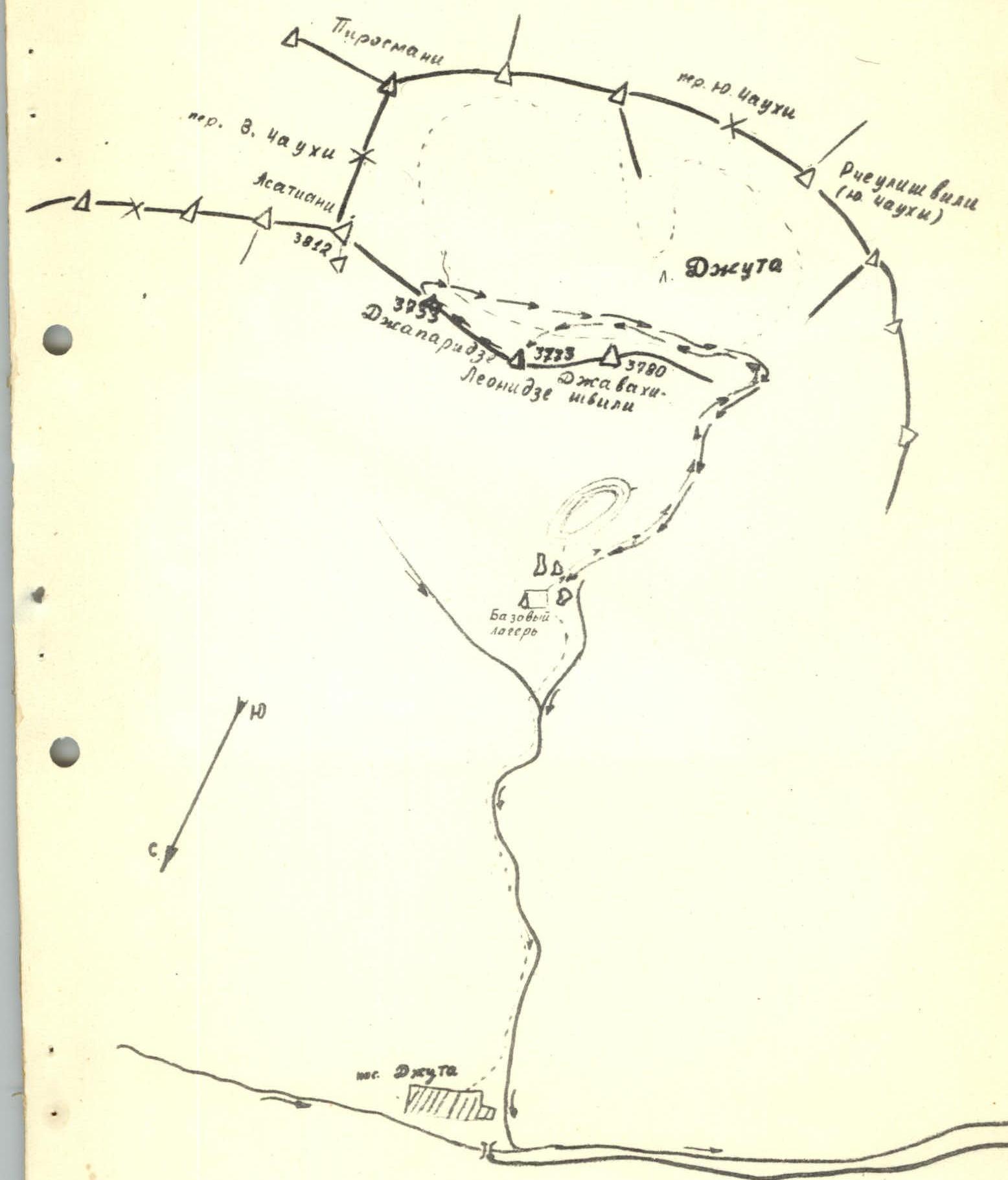
Table of main characteristics of the ascent route
| Date, Designation | Section characteristics | Weather conditions | Rock pitons | Notes | ||||
|---|---|---|---|---|---|---|---|---|
| Average steepness (in degrees) | Length (in meters) | Terrain characteristics | Difficulty | Condition | ||||
| July 29, 1980 | R1 | 50 | 40 | wall | 4 | ruined | Warm, sunny, cloudless, dry rocks | 5 |
| R2 | 30 | 20 | ridge | 2 | ruined | Same | 1, ledges | |
| R3 | 65 | 50 | wall and inner corner | 5 | monolithic | * | ||
| R4 | 10–15 | 10 | ledge, couloir | 3 | ruined, rockfall | * | 1 | |
| R5 | 90–95 | 15 | wall | 5 | monolithic | * | 4, 2 | |
| R6 | 40 | 70 | couloir | 3 | rockfall | * | 4, ledges | |
| R7 | 20 | 75 | ledge for one, wall and ledge | 2 | monolithic | * | 3, ledges | |
| R8 | 95–80 | 30 | 5 | monolithic | * | 4, 1 | ||
| R9 | 65 | 40 | inner corner | 4 | monolithic | * | 5 | |
| R10 | 45 | 40 | wall and inner corner | 2–3 | monolithic | * | ledges |
Route description
From the village of Juta, follow the path through the gorge to three large boulders under the Chauhi massif moraine. A bivouac is possible. (1.5–2 hours from the village).
Then descend into the depression between the lateral and median table-like moraines to the stream flowing from the Juta glacier.
Climb the steep moraine along the stream to the Juta glacier cirque.
Cross the glacier, veering left, to approach the base of the couloir separating peaks Djavakhishvili and Leonidze.
Staying on the right-hand side of the couloir, reach the South-West edge of peak Leonidze and exit onto a small talus ledge under the edge's base. (2–2.5 hours from the bivouac).
From the ledge, climb 35–40 m up to the edge with challenging climbing (piton protection). On the edge, there is a cairn.
20 m of simple climbing along the edge lead to a 40–50 m wall. Climb 15 m rightward along the wall, deviating slightly from the edge, then leftward along a faintly defined inclined ledge with an inner corner at the top. Climbing is above average difficulty; piton protection! Above the inner corner is a ledge. Then, climb 10 m rightward and upward to a platform under an outcrop. A leftward ledge bypasses the outcrop and leads into the throat of a rock couloir that must be crossed. Be cautious of falling rocks from above. After crossing the couloir, exit onto a ledge (cairn).
From the ledge, climb 15 m straight up the wall (challenging climbing, artificial footholds). Then, along the left-hand wall of the couloir, climb 70 m with medium difficulty climbing to a horizontal ledge (ledge composed of white rock).
From the ledge:
- leftward, 70–80 m above the precipice, to the Red Wall;
- up the wall, 30 m rightward with challenging climbing and overhanging lower section (artificial footholds) to a talus ledge;
- along the ledge rightward to an inner corner.
Climb the inner corner straight up, 40 m, with difficult climbing (piton protection). The inner corner leads to a broad horizontal platform. (Bivouac site, no water). 5–6 hours from the start of the route.
From the ledge:
- climbing 40 m rightward and upward with simple climbing leads to peak Leonidze;
- from the peak, descend 20 m leftward into a gap behind a rock (medium difficulty climbing);
- then, traverse 20 m along an inclined slab toward the saddle between peaks Leonidze and Japaridze (careful piton protection while moving along the slab);
- from the slab, rappel 40 m to the saddle;
- from the saddle, climb straight up the ridge, 80 m (climbing of medium and above medium difficulty, piton protection);
- then, climb 15 m up the ruined ridge to peak Japaridze.
4 hours from the bivouac on the ledge. Descent from peak Japaridze follows the 3A category route.
Photo taken from under the first ascent route, from the slope of peak Djavakhishvili
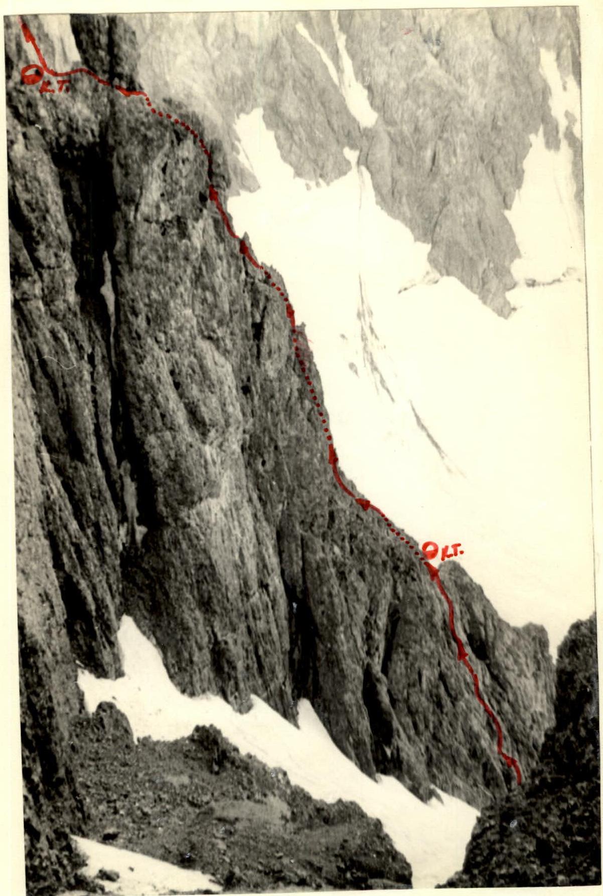
South-West edge of peak Leonidze. Section of the first ascent route up to the 2nd cairn.
South-West edge of peak Leonidze, its lower part. Photo taken from the Djavakhishvili — Leonidze saddle.
Comments
Sign in to leave a comment