Climbing Passport
I. Climbing category — rock climbing.
II. Climbing region — Eastern Caucasus, Rocky Ridge, watershed of the Armkhi–Assa rivers. Chechen-Ingush ASSR.
III. Peak, its height, climbing route — Girech Glavnaya, 3171.7 m, via the left couloir of the South face and the West ridge.
IV. Route characteristics:
a) height difference on the route — 920 m b) route length — 2970 m c) average steepness of the route — 35°
V. Pitons hammered for belaying (for creating ITO):
rock — 4 pcs., ice — none, bolt — none
VI. Number of climbing hours on the route:
to the summit — 8 hours.
VII. Number of nights and their characteristics: none
VIII. Proposed difficulty category — 1B
IX. Full name of the leader, participants, and their qualifications:
- KOZOREZOV A. G. — 1st sports category
- SIDENKO F. F. — 1st sports category
- LUKONENKO A. V. — CMS (Candidate for Master of Sports)
- KUROCHKIN A. G. — CMS
X. Team coach — KUROCHKIN A. G.
XI. Date of departure on the route and return to the base camp:
a) departure on the route — September 30, 1984
b) reaching the summit — September 30, 1984
c) return to the base camp — September 30, 1984
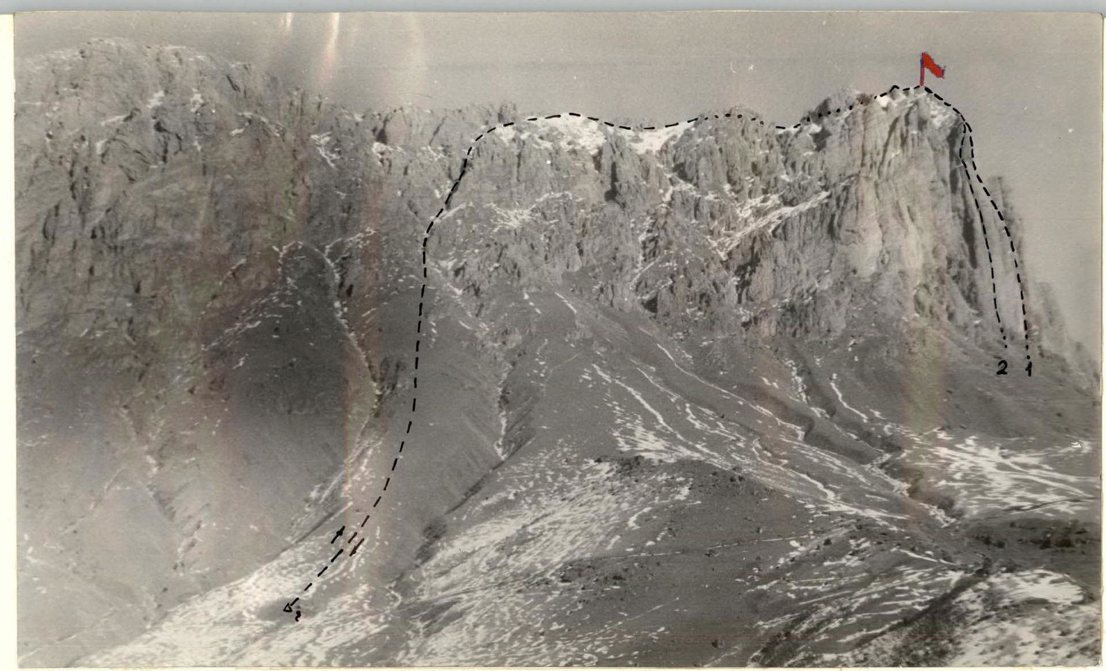
Photo I. General view of the Girech Glavnaya peak
- Girech Glavnaya, 3171.7 m, 5B category of difficulty, rock, via the center of the South face, first ascent — A. Kurochkin, 1983 (a/l "Ullutau" — III Caucasus championship, rock climbing class, II place).
- Girech Glavnaya, 3171.7 m, 5B category of difficulty, rock, via the Southwest face — V. Gorin, 1983 (a/l "Ullutau").
Description of the Climbing Region
The climbing object — Girech (Gaikamd) massif — 3171.7 m, is located in the Eastern Caucasus, in the southern part of Checheno-Ingushetia in the Rocky Ridge, on the border with the North Ossetian ASSR.
The Girech massif (Girech Glavnaya — 3171.7 m, Girech Central — 3100 m, Girech Eastern — 3162 m) is located in the center of the Rocky Ridge section (Tsey–Lam), bounded by the Terek and Assa river gorges.
This ridge is home to peaks:
- the well-known Stolovaya mountain — 2993.3 m,
- Jarlam — 2867.9 m,
- Girech — 3171.7 m.
Two 5B category routes are laid to the summit of Girech Glavnaya:
- Via the center of the South face, first ascent — A. Kurochkin, 1983 (a/l "Ullutau" — III Caucasus championship, rock climbing class, II place).
- Via the Southwest face — V. Gorin, 1983 (a/l "Ullutau").
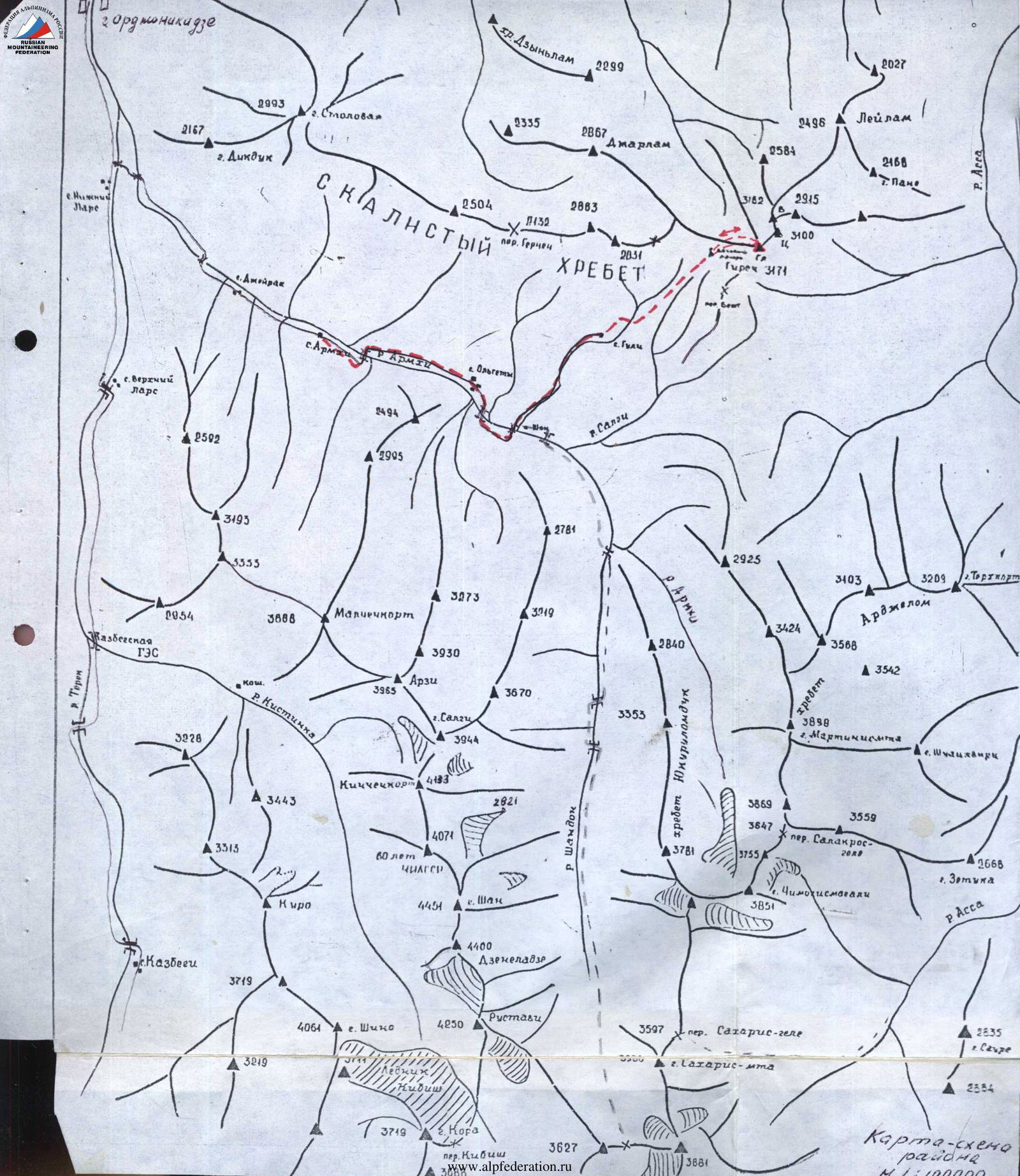
At the 21st km of the Military Georgian Road, the Terek River is joined by its left tributary — the Armkhi River. The road will lead to the "Armkhi" sanatorium (12 km), which is accessible by regular buses from the city of Ordzhonikidze. From the sanatorium to the village of Guli (12 km) can be reached by occasional transport, which is very rare.
From the village of Guli, follow a good pack trail under the 2050 m pass to a spring near large boulders — outliers. The spring is the base camp. It takes about 1.5–2 hours to walk from the village of Guli to the base camp.
From the camp to the Girech massif wall — 1 hour walk in the northern direction.
Rock structure: large monolithic blocks dissected by large cracks-fissures. A large number of small cracks and microrelief alternate with smooth overhanging slabs.
Rock type: fossilized limestone — soft dolomite. There is no water throughout the massif.
Description of the Ascent to Girech Glavnaya (3171 m) via the Left Couloir of the South Face
The path from the bivouac near the spring along a 25° grassy slope, the ascent to the route takes 1 hour 30 minutes, with small canyons on the right and left.
Traverse 300 m to the right canyon to a clearly defined couloir on the right. Along a narrow couloir with a scree slope with a steepness of 25–30° — 470 m to the first rock ascent. "Live" stones, stay connected!
Along simple destroyed rocks in the couloir with a steepness of 55–60° — 30 m to the expansion of the couloir. Further 260 m along a steep scree covered with deep snow to a sheer wall. Bypass to the left 40 m and along a narrow crevice — exit to the right onto the slope. 320 m along a scree slope covered with snow under the high rock spires of the gendarmerie on the ridge. Bypass the gendarmes on the left on the ridge, traversing along a 25° slope to the right 210 m with an exit to the ridge. Landmark — a rock niche in the gendarme on the ridge.
Traverse upwards 300 m along a 30° snowy slope of the ridge to a rock gendarme; bypass the gendarme on the left 30 m along a ledge. Further descent 50 m onto a snowy ridge along 35–40° destroyed rocks, 150 m along a snowy ridge upwards, 60 m along a 30–40° medium scree — ascent to a saddle between two gendarmes.
The right large gendarme with "reddish" slabs is bypassed along a ledge 60 m (belaying, rope protection, pitons!). Exit onto a snowy ridge 60 m.
Further along 25–40° simple, destroyed rocks of the ridge to the wall of the pre-summit ridge. From under the wall, traverse to the left 5 m — to a cleft (belaying, pitons!). Along an 80° cleft upwards 8 m onto the ridge. "Live" stones! Along a sharp rock destroyed ridge 40 m and further along 30° simple rocks 20 m — exit to the summit.
From the bivouac to the summit 7–8 hours.
Descent from the summit via the ascent route 4 hours 30 minutes.

Route Table by Sections
| Designation | Average Steepness | Length | Terrain Characteristics | Difficulty | Condition | Conditions | Pitons | Bolted | Ice |
|---|---|---|---|---|---|---|---|---|---|
| R0–R1 | 25° | 800 m | Grassy slope | 1 | Clear | simultaneously | clear | ||
| R1–R2 | 25–30° | 470 m | Couloir with small scree, medium-sized stones, scree slopes Couloir | 1 | Scree, rockfall | simultaneously | |||
| R2–R3 | 55–60° / 30° | 30 m / 260 m | Simple rocks; scree, stony couloir | 2 | Rocks are destroyed | Protrusions; holds, protrusions | |||
| R3–R4 | 40° | 40 m | Transition to a rock crevice | 1 | Slope with small scree, turning into rocks with a crevice | simultaneously | |||
| 25° | 320 m | Slope, medium scree, snow | 1 | ||||||
| R4–R5 | 30° | 510 m | Scree slope of the ridge | 1 | Small scree | simultaneously | |||
| R5–R6 | 30–40° | 80 m | Rocky slope | 1 | Destroyed rocks | via protrusions | |||
| R6–R7 | 40° | 380 m | Snow-rock ridge | 2 | Destroyed rocks, snow, scree | 2 | |||
| R7–R8 | 30–80° | 80 m | Ridge, rocks | 2 | Destroyed rocks | 2 | |||
| Total climbing hours to the summit | 7–8 hours | ||||||||
| Descent from the summit via the ascent route | 4 hours 30 minutes |