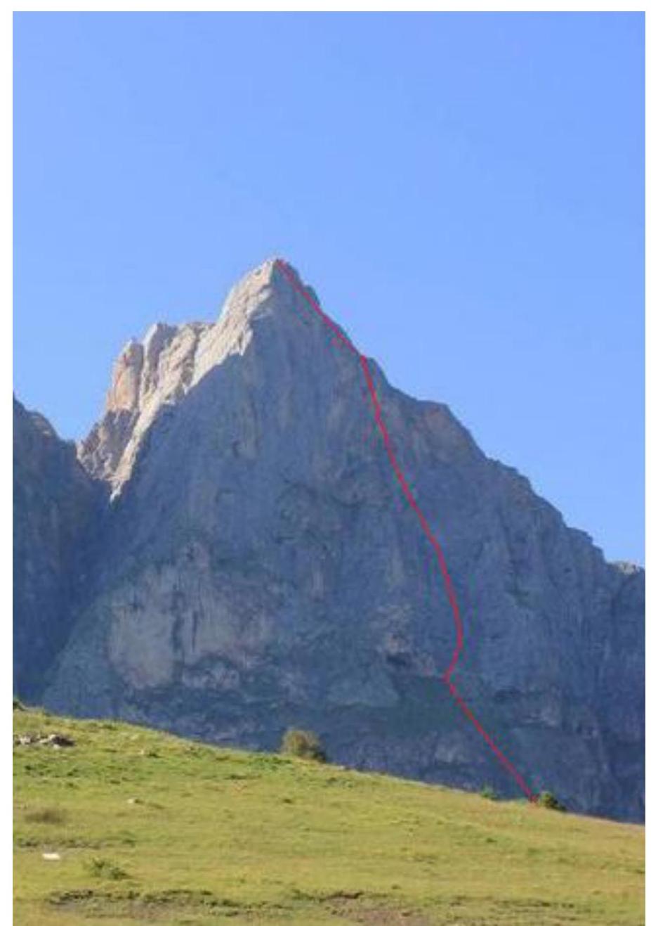
Report on the first ascent by the Ingushetia team as part of the winter alpinism championship to the summit of Gaikomd Central 3100 m
via the right buttress of the southern wall. Presumably 5B category of difficulty.
Route "SOVA". Team leader: Andreev A.B.
Ascent Passport
- Region 2.9. From Krestovyi pass to Shaviklde peak
- Gaikomd (C), 3100 m, via the right buttress of the southern wall
- Proposed category — 5B, first ascent
- Route type: rock
- Height difference: 1000 m.
Route length: 1330 m.
Section lengths:
- I category — 500 m
- II category — 40 m
- III category — 100 m
- IV category — 500 m
- V category — 140 m
- VI category — 50 m Average steepness:
- wall section — 70°
- entire route — 60°
- Protection used:
- Total/ITO — 99/12
- rock pitons — 72
- chocks — 26
- bolt pitons — 1 Protection left on the route:
- Total — 2
- rock pitons — 2
- bolt pitons — 1
- Team's climbing hours:
- 20 hours, 2 days
- including work on the route: 20 hours, 2 days
- Team leader:
- Andreev A.B. CMS Participants:
- Semenov M.A. CMS
- Korzhakov N.Yu. CMS
- Monaenkov A.V. CMS
- Coach:
- Kopylov A.M. CMS, instructor 2nd category
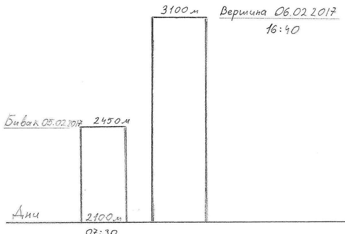
- Base camp setup and load carrying to the start of the route: February 5, 2017 Route started: 7:30 February 5, 2017 Summit reached: 16:40 February 6, 2017 Return to base camp: 14:10 February 7, 2017 Descent from the summit: via 4B route
- Team from Ingushetia
- Responsible for the report:
Semenov M.A. phone: +7 (906) 724–94–53
aravigehc@mail.ru
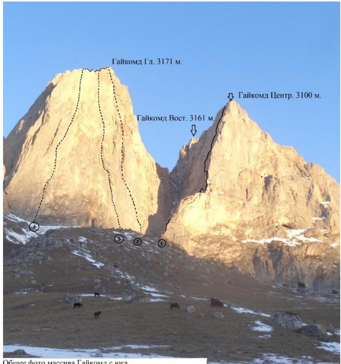
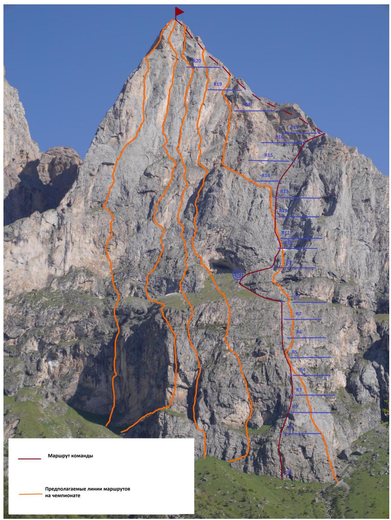
General photo of the Gaikomd massif from the south. Photo taken on November 24, 2015 from base camp at 2020 m.
- Team's route: left edge of the Southwest ridge A. Donskov, 2015
- Center of the Southeast wall A. Kharitonov, 1986
- Left part of the Southeast wall K. Dorro, 2003
- Center of the South wall A. Kurochkin, 1983
Overview of the Climbing Area
The Gaikomd peak massif is located in the Skalisty Range of the Greater Caucasus, between the Terek River (to the west) and the Assa River (to the east).
Gaikomd Central peak:
- Is the third highest peak in the massif, after the Main and Eastern peaks.
- Previously known as "Girech" in the classifier.
- The administrative border between the Republics of Ingushetia and North Ossetia-Alania runs along the Skalisty Range to the Gaikomd peak, then continues north.
The ascent route and approaches to the peak are located within the Dzheyrakhsky district of the Republic of Ingushetia.
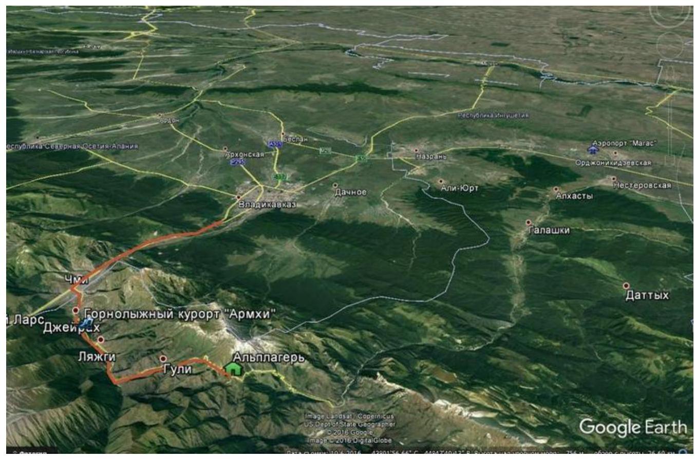
The base camp is most conveniently set up near the Besht pass, 100 m before the turn to the "Otdelenie Besht" border post, on a clearing 100 m from the road to the left. There is year-round water available at the water intake point.
No border permits are required to visit the Gaikomd peaks, but it is necessary to notify the border post of your presence.
Only Beeline cellular network has stable coverage. The weather in the area is stable, with snow melting quickly on the routes. In winter, after heavy snowfalls, be cautious of couloirs and lee slopes due to potential avalanches.
Approach to the route: 1 hour. Follow the road to the couloir leading to the southern wall of Gaikomd Central, then up the couloir. In the middle section, cross to the right bank, then follow the grassy slopes to the right buttress.
The route starts on a wide, long grassy ledge to the left of the buttress.
The route is relatively monolithic, with minimal loose rocks, despite some snow on the ledges. The terrain is diverse:
- many dead-end cracks
- often challenging to organize protection points
- mainly anchor pitons were used
Descent is via 4B route. The upper part of the route is the key section. No signs of human habitation were found on the route. A note from a team from St. Petersburg, route #13, was found on the summit on February 5, 2017.
| Section | Pitons | Chocks | Length | Steepness | Difficulty |
|---|---|---|---|---|---|
| R0–R1 | 5 | 4 | 30 m | 60–70° | IV+, V |
| R1–R2 | 3 | 2 | 50 m | 60° | III+ |
| R2–R3 | 3 | 50 m | 75° | IV+ | |
| R3–R4 | 3 | 1 | 50 m | 75° | IV+ |
| R4–R5 | 2 | 1 | 50 m | 65° | IV+ |
| R5–R6 | 3 | 50 m | 70° | IV+ | |
| R6–R7 | 3 | 50 m | 75° | IV+ | |
| R7–R8 | 2 | 2 | 50 m | 70° | IV+ |
| R8–R9 | 100 m | 40° | I+ | ||
| R9–R10 | 3 | 50 m | 60° | IV- | |
| R10–R11 | 6 | 4 | 40 m | 80° | V+ |
| R11–R12 | 5 | 1 | 50 m | 70° | V |
| R12–R13 | 4 | 3 | 50 m | 70° | IV |
| R13–R14 | 3 | 50 m | 60° | III | |
| R14–R15 | 4 | 50 m | 65° | IV- | |
| R15–R16 | 3 | 2 | 50 m | 75° | IV+ |
| R16–R17 | 3 | 50 m | 40° | II+ | |
| R17–R18 | 4 | 4 | 40 m | 80° | V+ |
| R18–R19 | 8 | 4 | 50 m | 85° | VI- |
| R19–R20 | 6 | 50 m | 75° | V- | |
| R20–R21 | 300 m | 45° | I+ |
Movement schedule on the route
Route Description
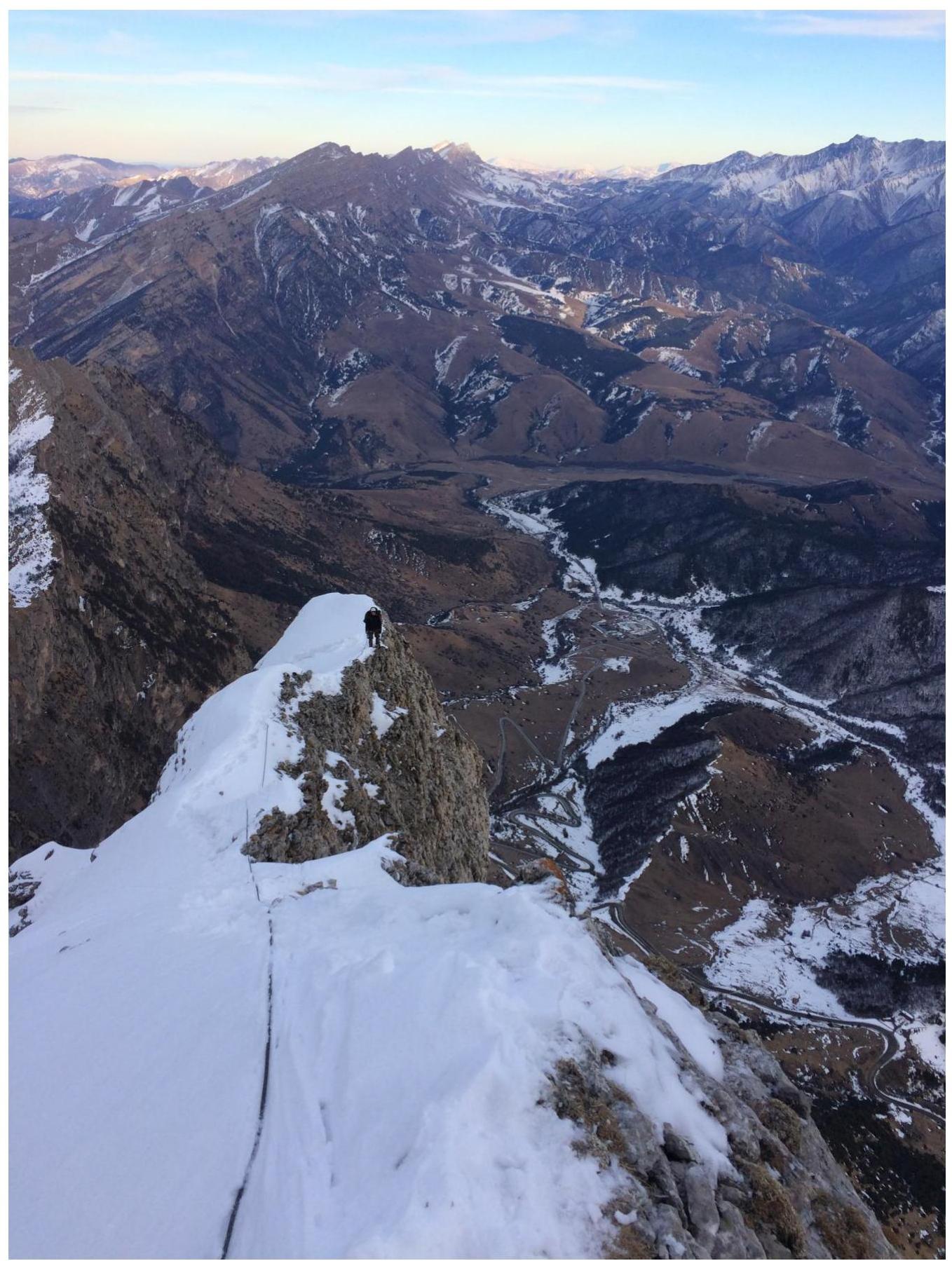
R0–R1 — V category, 70°, 20 m up a crack, landmark — a tree above the crack. IV category, 60°, 30 m. Convenient belay station. R1–R2 — III category, 50–60°, 50 m up inclined walls to a wide, horizontal grassy ledge. Convenient belay station. R2–R8 — IV–IV category, 60–75°, 6 ropes (approximately 50 m each) up the buttress via a system of walls, ledges, and internal corners — exit onto a huge inclined grassy field. All belay stations are convenient; issues with protection points; stations mainly organized with anchors. R8–R9 — I category, 30–40°, 100 m up and left to a huge grotto above a ledge; convenient bivouac in front of or inside the grotto for multiple tents. From the grotto, slightly down and traverse right to a poorly defined internal corner at its base — belay station. Convenient belay station. R9–R10 — IV category, 60°, 50 m up and right along a small wall transitioning into an internal corner, then up and left through the corner — exit onto a wide inclined snowy ledge (possible bivouac). Convenient belay station. Up the ledge to the base of an internal corner. R10–R11 — V category, 80°, 40 m up an internal corner — chimney to a ledge; belay station on the ledge. Semi-convenient belay station. R11–R12 — V category, 65–70°, 50 m: from the ledge, a challenging traverse left, transition into another internal corner (ITO), up the internal corner towards a large rock; the large rock is bypassed on the right. Convenient belay station. R12–R13 — IV category, 65–70°, 50 m up and left through an internal corner and further up via a system of internal corners and small ledges — exit onto a horizontal ledge. Convenient belay station. R13–R16 — III to IV category, 60–75°, 3 ropes (approximately 50 m each) up relatively easy rocks on a poorly defined buttress, up and right. With each rope, the difficulty and steepness increase — to a long horizontal ledge before a wall. All belay stations are convenient, on anchors; the last one is on a protrusion (a wedged rock). R16–R17 — II category, 0–40°, 50 m simple traverse along a horizontal ledge, up and right — transition to another ledge. Convenient belay station. R17–R18 — V+ category, 80°, 40 m: along the ledge, right around a corner, then up an internal corner. Convenient belay station with a bolt. R18–R19 — VI category, 85°, 50 m challenging climbing up an internal corner, partly ITO under a cornice, transition left into another internal corner and up to a small ledge. Convenient belay station. One piton left. R19–R20 — V category, 75°, 50 m up a crack 25 m to the ridge, then initially along the right part of the ridge, then left — onto the ridge. Convenient belay station over a bend, working upwards. R20–R21 — I category, 10–40°, 300 m initially along the ridge, transitioning into a couloir — to a saddle between two peaks. Bivouac possible in the saddle (2 tents). From the saddle to the summit — 25–30 m.
Route profile (left)
Technical Photos
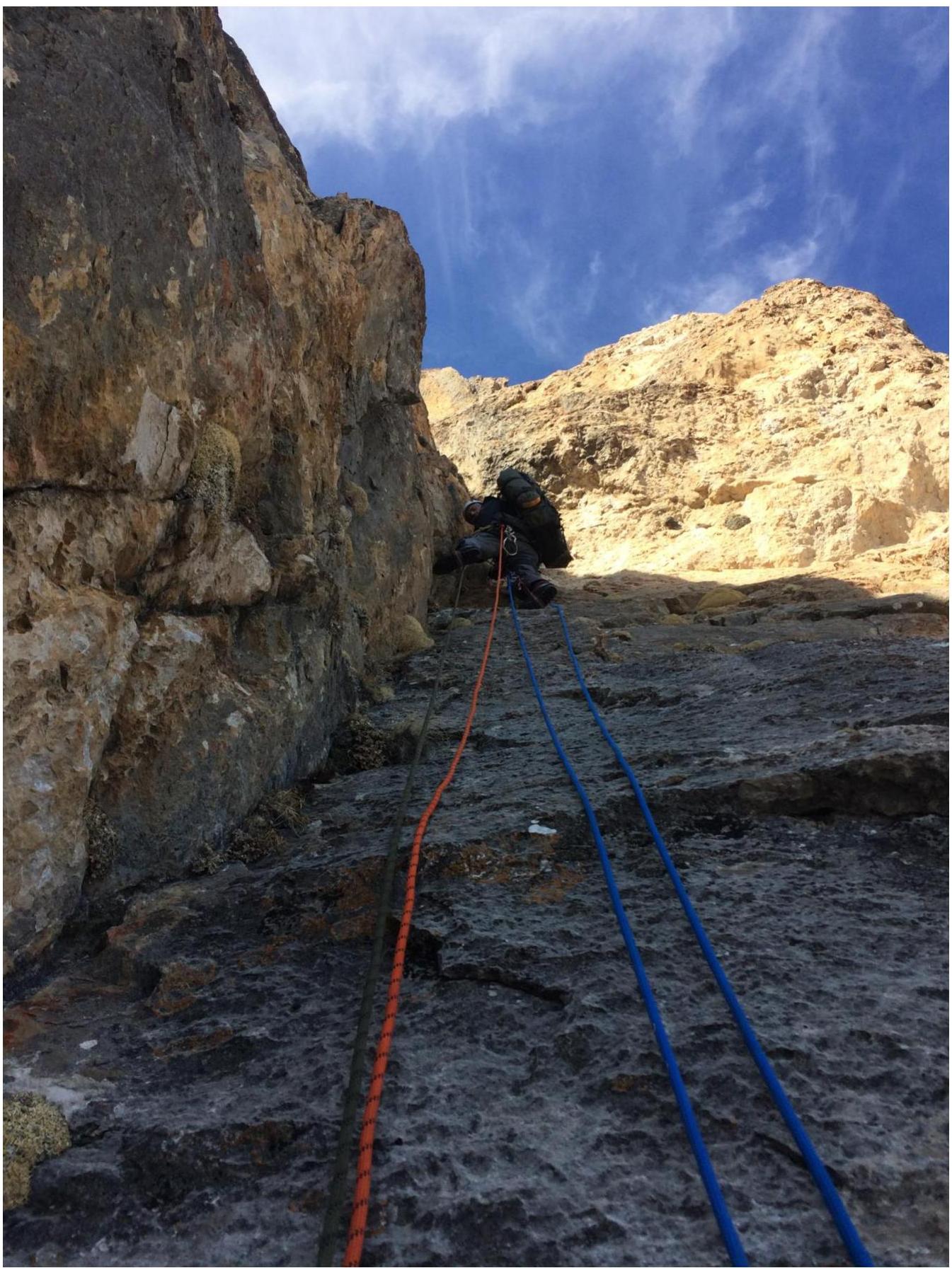
R18–R19
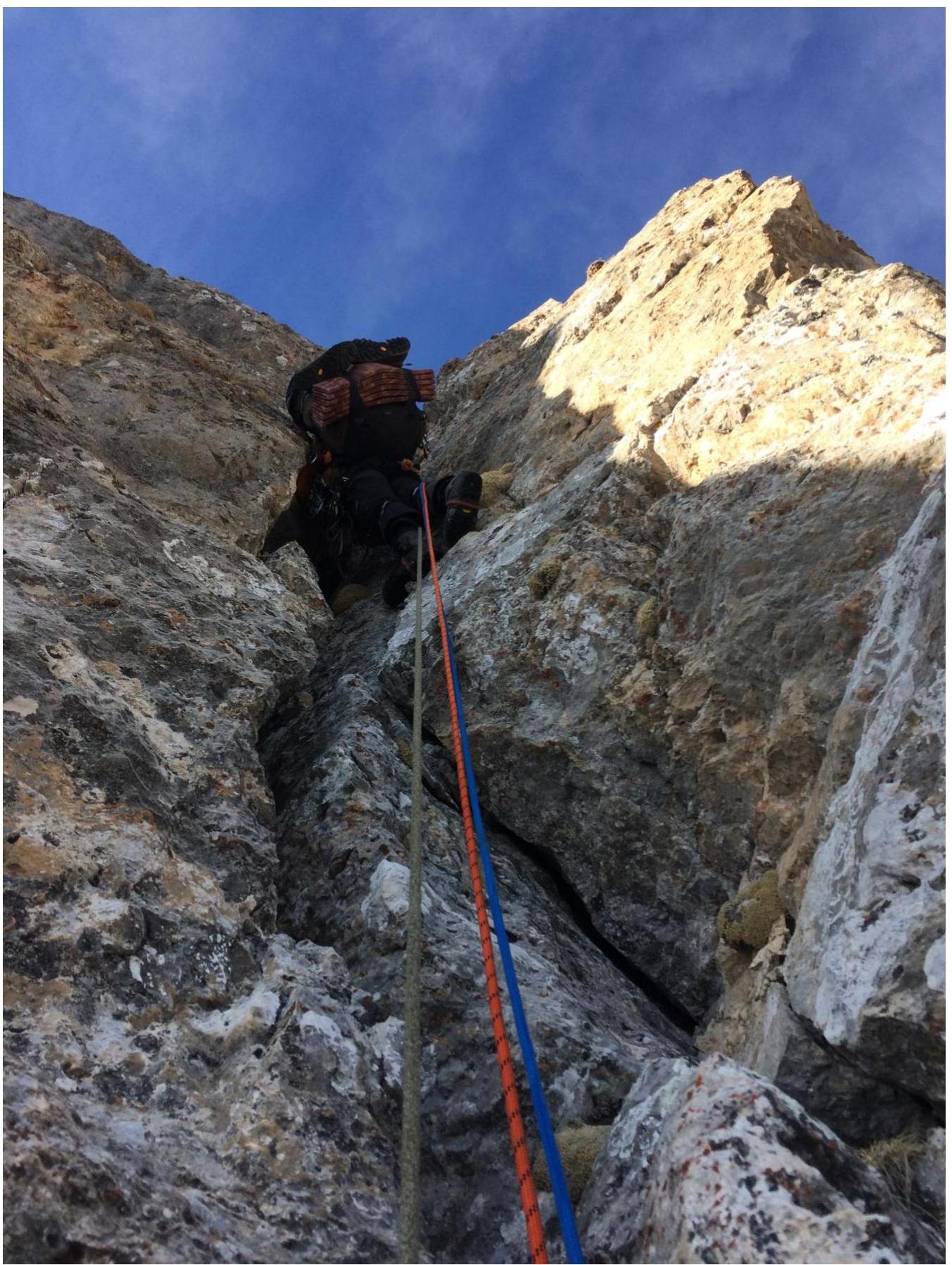
R19–R20