Ascent Passport
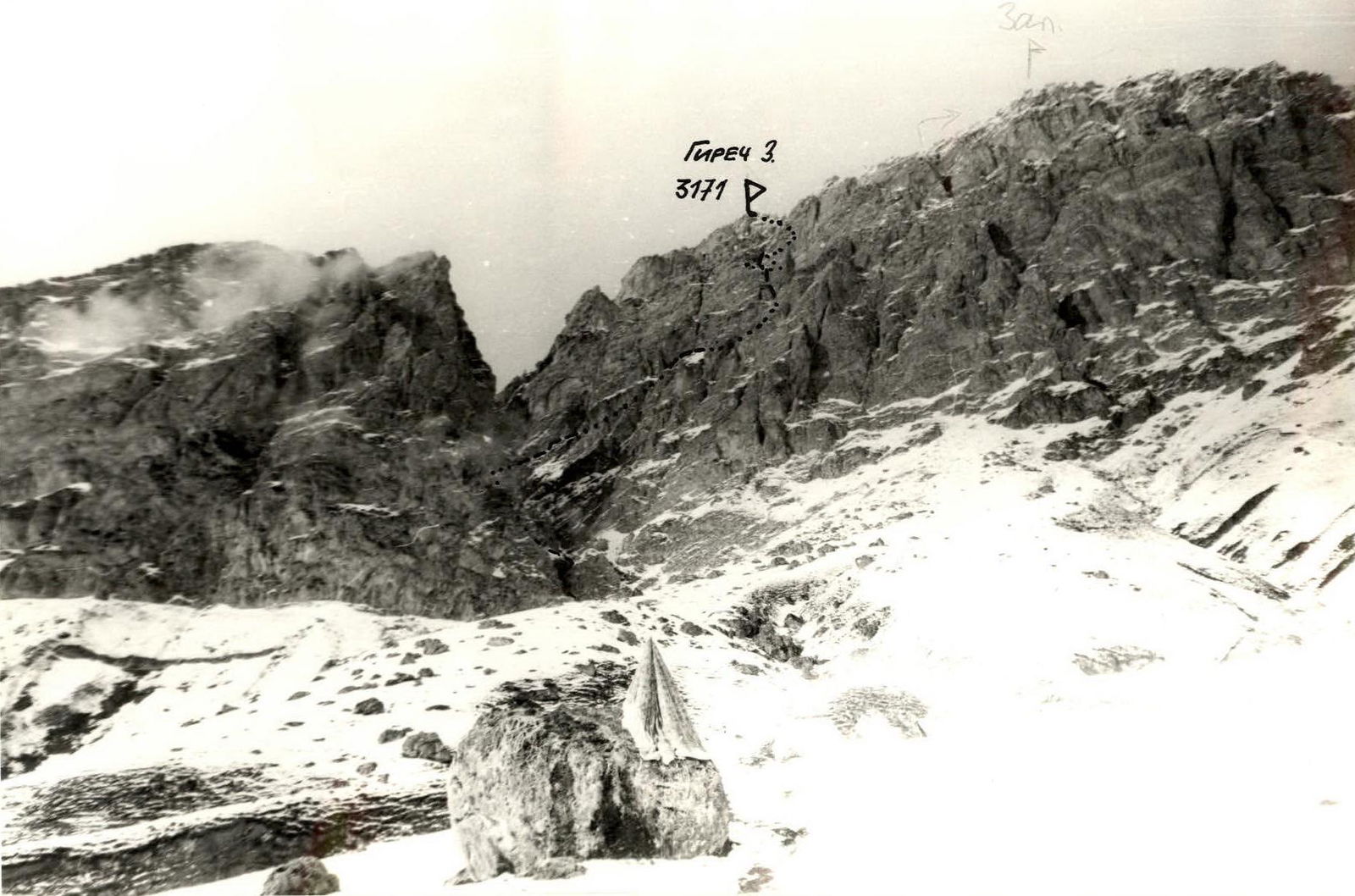
I. Climbing category — rock climbing 2. Climbing area — North-Eastern Caucasus, Girech Jarlam 3. Summit Girech West via South-West edge, rock climbing, height 3171 m. 4. Proposed category complexity — 3B 5. Height difference — 670 m. Distance — 980 m. Average steepness — 45° 6. Rock pitons hammered — 27/17, chocks — 34/9 7. Climbing hours — 12 8. Leader — Tikhonov Anatoliy Nikolaevich — 1st sports category
Team members:
- Pyshkin Alexander Vladimirovich — Candidate Master of Sports
- Glushchenko Alexander Andreevich — 1st sports category
- Shkola Natalia Ivanovna — 1st sports category
- Team coach: Mityukhin Fedor Petrovich — Master of Sports
- Departure date: May 10, 1988. Return date: May 10, 1988.
II. Organization: Sumy regional council DSO trade unions team

Description of the approach to the route
Leaving the base camp, which is located in a convenient place (70–100 m from the road), we move towards the overgrown gully (on the left side of the camp). The gully is overgrown with bushes and trees, and there is a stream at the bottom. It is advisable to start not later than 7:00.
Cross the gully and move up the trail, which ends under a large boulder. Then move up the grassy slope towards the visible couloir above. In spring, the couloir is snowy. The approach to the couloir from the base camp takes 50–60 minutes.
In the lower part of the snow-scree couloir, there are two two-meter walls that are overcome by climbing on the right side of the overhanging rock. Then, sticking to the left part of the couloir, move up the snow. In the upper part, the couloir narrows sharply. At the top, the "crown" is visible.
100 m before the "crown", above the "white knife" (on the rocks — a white granite vein), 50 m to the right — narrow inclined grassy ledges — the start of the route. From the start of the couloir to the route — 40–50 minutes.
Route description by sections
- R0–R1. Along narrow grassy ledges, approach the start of the internal angle. Insurance with the pick of an ice axe against the slope. Danger of slipping down in case of wet weather.
- R1–R2. Move up to the right along the internal angle overgrown with grass, towards the walls. Insurance with an ice axe against the slope. At the start of the internal angle, there is a "station" on large chocks or channels.
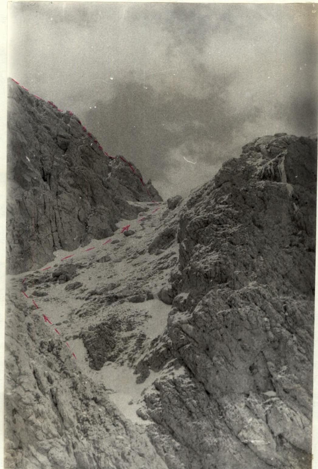
- R2–R3. Traverse to the right under the walls, crossing three consecutive scree couloirs, to the corner, to extensive grassy ledges (lower step), going to the right towards the central large wide scree couloir. Insurance with ice axes against the slope and a rope through ledges.
- R3–R4. Traverse along grassy ledges to the central large wide scree couloir, the descent into which is interrupted by walls. On the left, there will be an internal angle with an overhang in the upper part, leading to the middle rock-scree step.
- R4–R6. Up the internal angle, bypassing the overhang on the right, to a scree slope that is not too steep, going along the edge of the central couloir. Piton insurance, alternating movement. The first climber should wear galoshes. Any pitons and chocks can be used.
- R6–R7. Along the scree slope and then along small rock ledges of the wall of the central large wide scree couloir — exit to a narrow rock-scree ledge with large rock outcrops. Further path along the steep slope of the couloir is blocked by a steep wall. From the ledge, a 25 m rappel down to the bottom of the central large wide scree couloir.
- R7–R8. Up the couloir under the walls of the "crown", the main wall rock massif of the summit Girech West. On the left, there is the upper rock-scree step. On the right, there is a scree slope going up with large boulders in the upper part.
- R8–R9. Up to the right under the walls towards large boulders. Control cairn. Highest point of the scree counterfort. From it up the wall — the key section of the route.
- R9–R11. Up to the right along the vaguely defined walls of internal angles to a sharp rock "knife". Piton insurance, chocks. Alternating movement, rope protection.
- R11–R12. Along the sharp rock "knife" around the corner to the start of the internal angle, steeply going up. Alternating movement on top of the "knife". Insurance for the first climber through the "station" at the start of the "knife", for the last — through the "station" at the end of the "knife".
- R12–R13. On the right side of the internal angle up to the right to the exit to the pre-summit rock-scree gentle ledges. Piton insurance. Alternating movement, rope protection.
- R13–R14. Along gentle simple rock-scree ledges, securing oneself to outcrops, exit to the summit. Simultaneous movement on the entire rope.
Descent from the summit to the right along route 2A category complexity.
Section R8–R9–R10