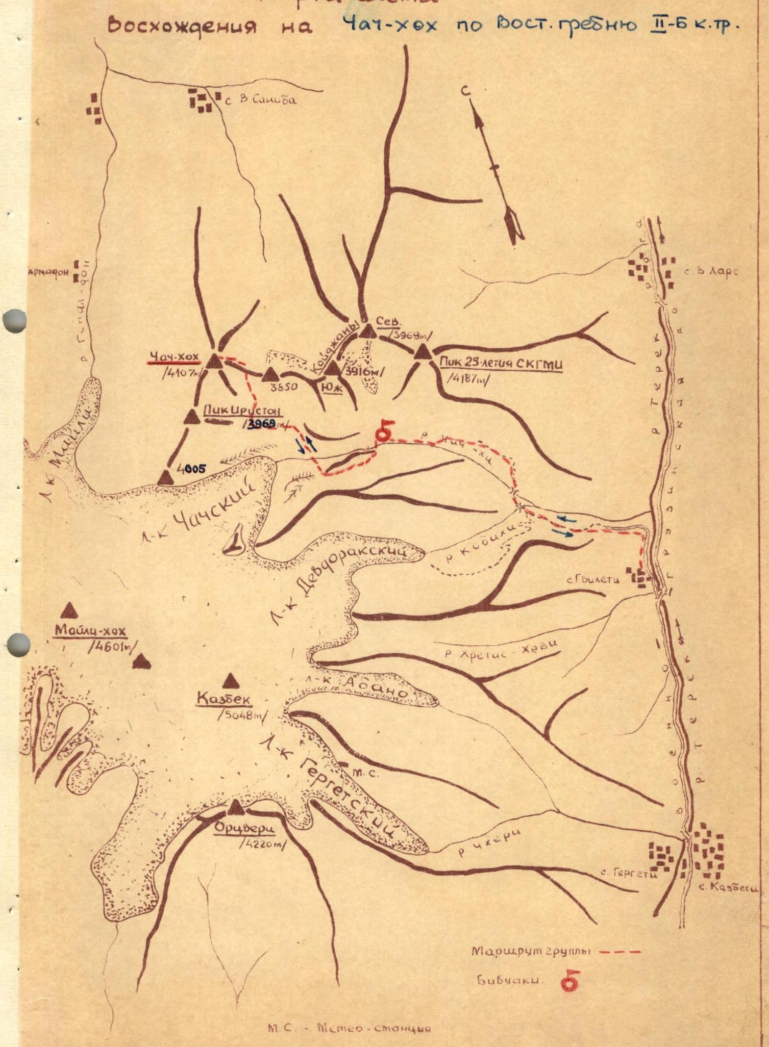
ROUTE DESCRIPTION
to the summit of Chach-khokh, category 2B complexity (height 4107 m) via the eastern ridge, approved on 17/2-67.
The summit is located in the watershed ridge (between the basins of the Genal-don and Chach-khi rivers), connecting the Kazbek plateau to the south with the peak Iriston and further to the north with S. and Y. Kaidzhany. The summit has been visited repeatedly by mountaineering groups. All ascents were made from the Chach valley. The route is classified.
Day 1
The group travels by car along the VGD to the village of Gvileti, from where it is no more than 1 hour's walk along a dirt road to the confluence of the Kebati and Chach-khi rivers.
After crossing the Kebati River and then the Chach-khi River at their confluence, the group heads along a trail to the right (Chach) valley. The trail winds up the slope and leads to the first "gates" of the Chach valley (a height difference of about 300-400 m).
Next, it is necessary to go up to the right. Overcoming the "ram's foreheads of the gates" along one of the shelves that divides them, you should climb up the grassy slope to a group of trees, from which a well-trodden trail begins again.
Follow the trail into a wide couloir, cross a stream, after which the trail turns sharply to the right under the rocks. Following along them, it will lead to a shoulder forming the first "gates" of the valley.
It takes about 1.5 hours to walk from the confluence of the rivers to the pass point of the first "gates".
The "ram's foreheads" must be passed with caution and gymnastic belay.
From the pass point, there is a view of the Chach valley in the middle reaches of the Chach-khi River.
Along a trail that traverses grassy slopes and a series of scree couloirs, you can reach the second "gates" of the valley in 40 minutes, which are a small rocky gorge in the river floodplain. The descent to the "gates" is along the scree. The "gates" can be passed along the right (along the route) slope of the valley or directly in the river floodplain. In front of the "gates" there is a terrace on the right (orographic) bank (under the slopes of Bart-Kort), where you can organize an overnight stay.
From the second to the third "gates" it is more convenient to move along the trail in the river floodplain. After 40 minutes of walking, they reach the place where the floodplain widens in front of the third "gates", where it is convenient to set up a bivouac and where a wide trough-shaped couloir descends from the slopes of the Kaidzhany massif, originating from the trough of the Kaidzhany glacier.
Day 2
The "third gates" are passed on the left along the route, along a grassy slope, following the slopes of Bart-Kort. Having climbed up, they find themselves in the Chach basin, which is a huge cirque filled with scree, moraines and preserving in its southwestern part the tongue of the Chach glacier descending from the Kazbek plateau, from under which the Chach-khi River originates.
Above the third "gates" of the valley, it is convenient to set up a base camp, from which you can ascend the peaks surrounding the Chach basin:
On the left bank side of the valley, a convenient exit to the ridge of the Chach glacier moraine is visible, leading to the buttress of the peak of the Ordzhonikidzevskaya railway.
From the base camp, on the right bank side of the Chach-khi River, descend to the river, traversing scree and gullies. Having crossed to the left bank of the Chach-khi River (crossing over the stones), you should climb up along a barely noticeable trail to the ridge of the moraine.
Having climbed up onto the moraine, they traverse the scree slopes to the left and cross a deep gully that cuts through the moraine. Here, the moraine hill is separated from the slope by a wide "pocket" with a flat bottom.
A tourist trail leads along the ridge of the moraine. You need to descend 100 m into the "pocket" and climb up the slope along a large-block (initially) scree. As you climb, the scree becomes smaller.
To the right (to the east), the slopes of the scree "terrace" are visible, representing the mouth step of a hanging valley, into which you need to climb.
Having climbed up to the height of the step, you should traverse the scree slopes in the opposite direction, go around, without losing height, the end of the southeastern ridge of Chach-khokh (the massif hides the summit) and enter the hanging valley, completely filled with the moraines of the glacier that once existed here.
Along the moraine hills and fields, they enter the upper cirque of the valley, where:
- to the right rises the massif of peak 3850 m;
- to the left is the massif of Chach-khokh.
You should climb up to the saddle between them along a "live" scree (150 m long and 40° steepness) near the massif of Chach-khokh.
When climbing up the live scree to the saddle, beware of falling stones from the couloirs on the left.
In the valley under the moraine covers, water flows in some places, which can be easily reached if necessary. In the valley, you can set up a bivouac, from which it is convenient to ascend:
- Chach-khokh;
- Peak "3850";
- South Kaidzhany (via 3850 m).
It takes about 3-4 hours to walk from the third "gates" to the saddle.
On the saddle, you should rope up. The further ascent goes in a westerly direction along the narrow, extremely destroyed rocky ridge of Chach-khokh:
- To the right and left, very steep rocky slopes descend;
- Belay through ledges, in some places - alternate.
250 m along the eastern ridge merges with the massif of the southeastern ridge of Chach-khokh. A very narrow saddle leads to a small rocky wall (4-5 m), behind which is a snowy slope leading to the foot of a rocky wall.
At the base of the wall, traverse the slope to the left, for which you need to cut out a dozen steps in the ice that has formed under the wall. The slope leads to the left along the ice and then onto a wide destroyed ridge. The described section, 40-50 m long, is the most difficult place on the route:
- Belay is carried out through ledges or rock hooks.
- The rocks are very brittle - caution is required.
A 200-meter ascent up a wide destroyed ridge with individual outcrops of bedrock leads to the pre-summit plateau of Chach-khokh (an expansion of the ridge). Ahead, to the west, 300 m away, the summit tower of Chach-khokh is visible.
To the right, in the direction of Saniba, huge cornices overhang (do not approach the cornices), to the left - steep rocky-scree slopes of the massif, descending into a hanging valley between the massifs of Chach-khokh and Peak Iriston.
Having passed the pre-summit plateau, they begin the ascent along simple destroyed rocks of the couloir, leading to the left of the base of the tower onto the southern ridge of Chach-khokh, near the junction with the tower.
From the ridge, there is a view of Zertnii Karmadon and the Maili glacier.
The final twenty-meter ascent up gentle and easy rocks leads to a cairn on the summit of Chach-khokh (4100 m).
It takes about 2.5 hours to ascend from the saddle between Peak 3850 and Chach-khokh to the summit.
The descent along the ascent route to the bivouac under the third "gates" of the valley takes 2 hours.
Having gathered the bivouac, on the same day you can:
- from the bivouac site to the Military Georgian Road - 2 hours 30 minutes walk;
- return by car to the city of Ordzhonikidze.
Equipment recommended for a group of 4 people
- Main ropes (30 m) - 2 pcs.
- Rock hooks (with a long blade) - 5 pcs.
- Carabiners (group) - 4 pcs.
- Repschnurs (5 m) - 4 pcs.
Description compiled by R. Proskuryakov
1965, Ordzhonikidze, SOASSR
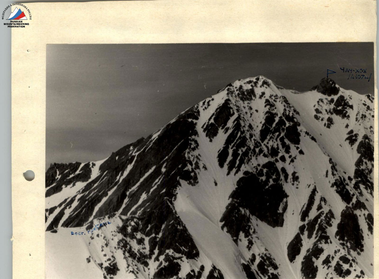
Chach-khokh. Route along the eastern ridge, category 2B complexity.
Photo by R. Proskuryakov
Map-diagram of the ascent to Chach-khokh along the eastern ridge, category 2B complexity.