
Ascent Passport
-
Rocky Ridge, section number 2.8 in the classification.
-
Tbau N-W 2980 m, via cornices on the South-West wall.
-
Proposed 5B category; first ascent.
-
Route type: rock.
-
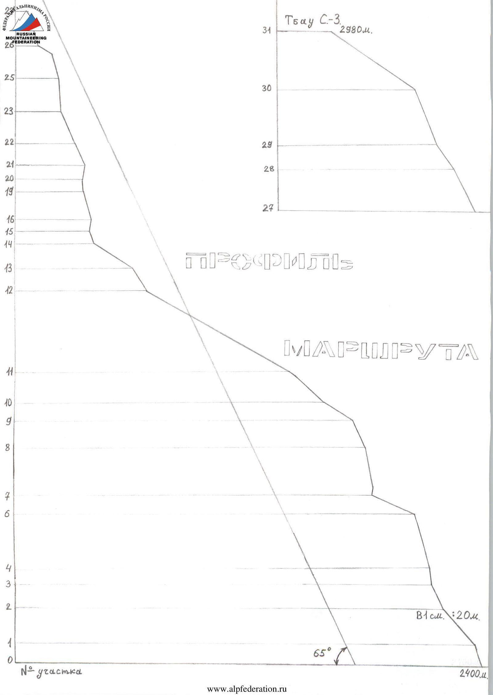
Route height difference: 580 m (by altimeter and topographic map).
Route length: 950 m. Section length:
- 5 category – 52 m.
- 6 category – 27 m.
Average steepness:
- main part of the route – 75°
- entire route – 65°
-
Pitons left on the route: total 39; including 38 bolts, of which 32 are spits.
Pitons used on the route:
- stationary bolts – 6, including 1 for artificial climbing aids (I.C.A.);
- removable bolts (spits) – 32, including 14 for I.C.A. Total artificial climbing aids (I.C.A.) used – 18.
-
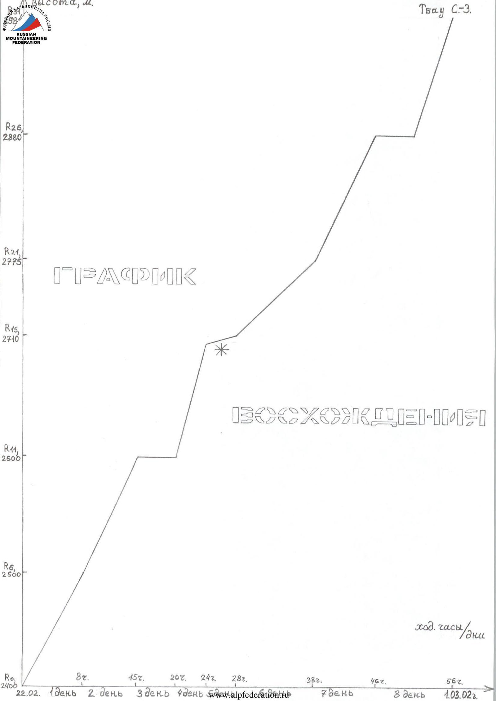
Team's climbing hours: 56 hours; 8 days.
-
Leader: Egorin Sergey Vladimirovich; Master of Sports.
Participants:
- Gagaev Vilyam Taymurazovich; 2nd sports category
- Zubenko Vladislav Sergeevich; 2nd sports category
- Chupin Vyacheslav Mikhailovich; 2nd sports category
- Chupin Roman Mikhailovich; 2nd sports category
-
Coaches: Khamitsaev Kazbek Borisovich; Tavasiyev Ruslan Andreevich.
-
Approach to the route: 8:00, February 22, 2002.
Summit: 16:00, March 1, 2002. Return to Base Camp: 12:00, March 2, 2002.
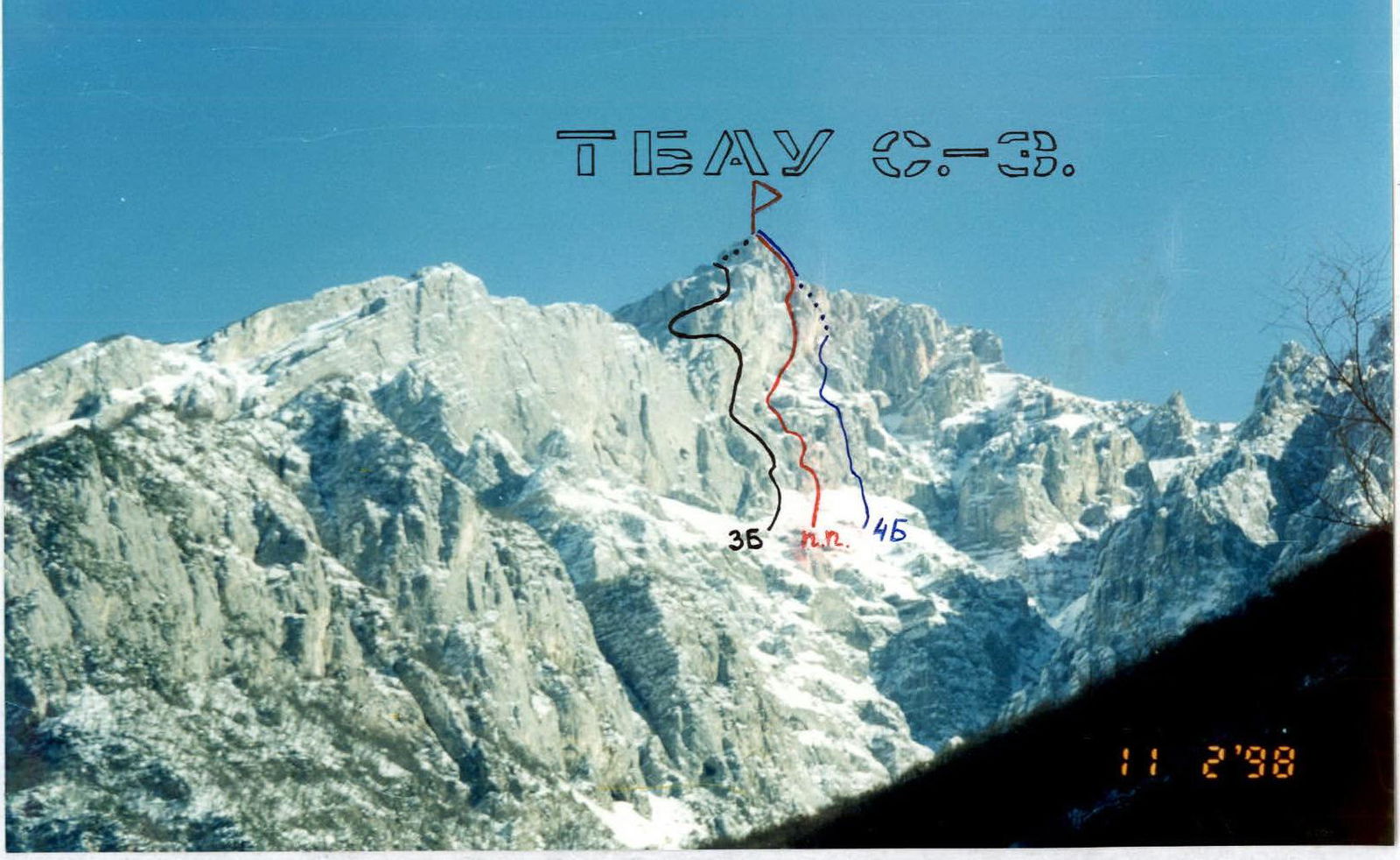
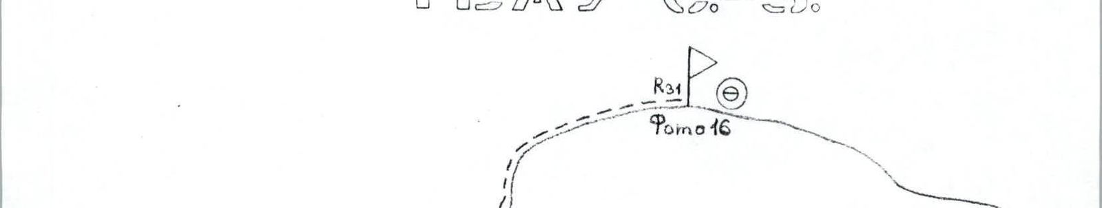
Photo 1. General view of Tbau N-W peak. February 1998. Routes on the South-West wall are marked. Photo taken from Kurtatinskoye gorge, from "Metallurg" pioneer camp – double magnification.
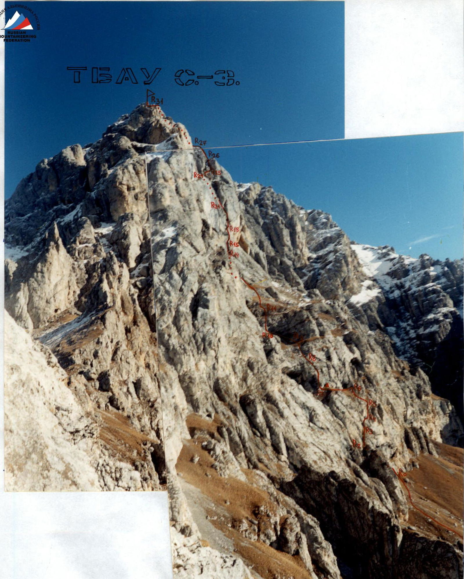
Photo 2. Left part of the wall profile. October 1996. First ascent route is marked.

SCALE 1:400,000 – 4 kilometers in 1 centimeter
Middle Pripyatinskoye gorge
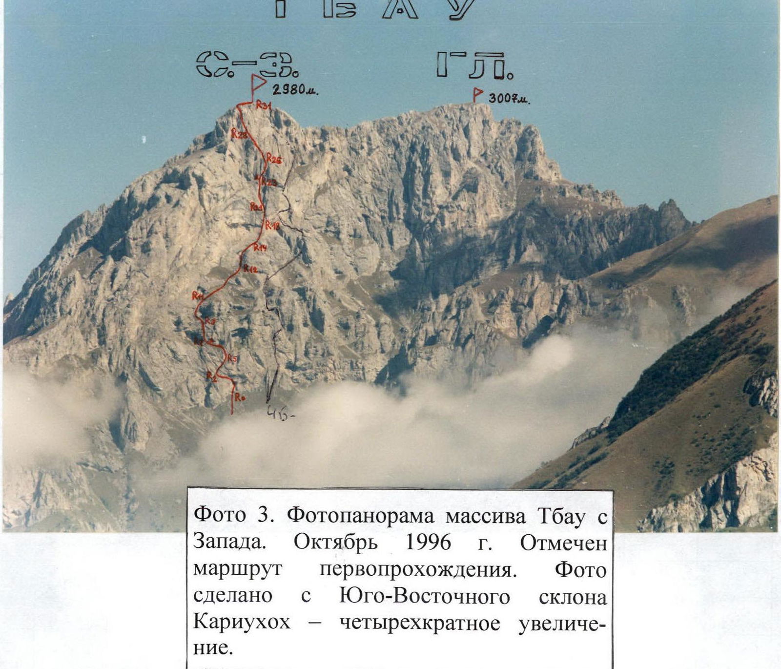
Photo 3. Photopanorama of Tbau massif from the West. October 1996. First ascent route is marked. Photo taken from the South-East slope of Kariuokhokh – fourfold magnification.
Overview of the Climbing Area. History of the Peak's Exploration
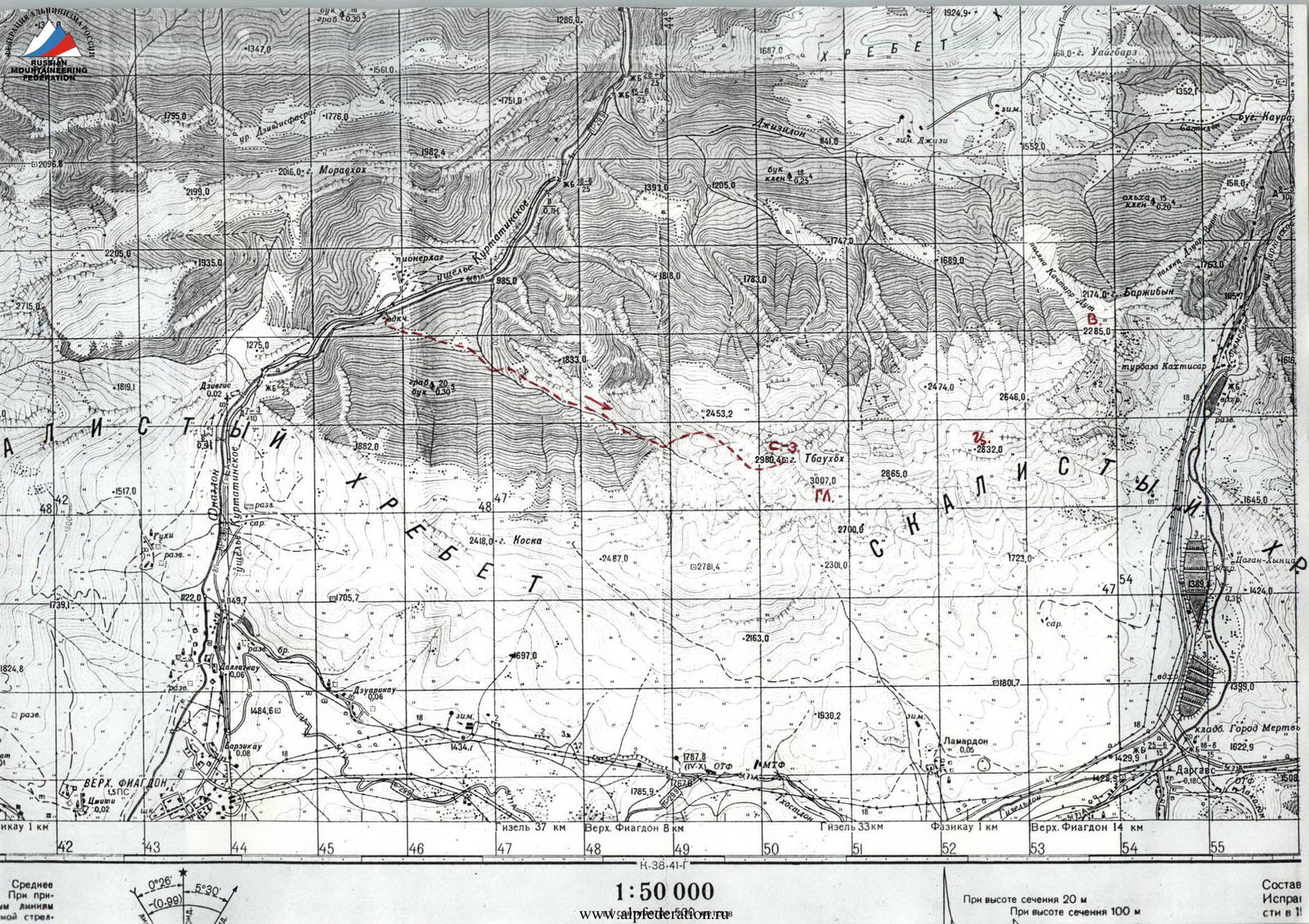
The climbing area is located within the Republic of North Ossetia – Alania, between the Fiagdon River to the West and the Gizeldon River to the East.
The Tbau massif is situated in the Rocky Ridge and stretches over three kilometers in the latitudinal direction.
The rocks forming the Tbau massif are of sedimentary origin:
- limestones,
- dolomites,
- marbles in some areas.
The rocks are often monolithic, without cracks. Like most peaks of the Rocky Ridge, Tbau is a typical escarpment, with relatively gentle northern slopes and steep southern slopes featuring wall outcrops.
The highest point of the massif is Tbau Main (3007 m); further east along the ridge lies Tbau Center (2832 m), and even further east is a small tower, Tbau East (2285 m).
On a spur branching off the main peak is the North-West Tbau tower, which is the most interesting for alpinists. Its South-West face drops 600 meters into the Kurtatinskoye gorge.
Previously, ascents to Tbau Main and North-West were made from the South-East, from the villages of Dargavs and Lamardon, via non-categorized routes for training purposes. Even then, many alpinists from Vladikavkaz were drawn to the wall overlooking the Kurtatinskoye gorge.
The first passage on the left edge of the wall was made in 1994 by a group led by Yu. Levkovsky (currently a 3A category route).
In 1996, the duo Egorin S. and Afanasyev I. climbed the left, less steep part of the South-West wall (a 3B category route with a wall section height difference of 300 m).
The following year, a group led by Glazov A. climbed the wall almost directly over three days in October. However, on the second bastion, due to the high technical difficulty of the path through the cornices, they deviated right to bypass this section. Their route is now categorized as 4B.
In December 2001, our team made the second ascent of this route. We then planned our future route, deciding to:
- climb the first bastion left of Glazov's route;
- ascend the second bastion directly through the cornices – at the junction of two large cornices and further via chimneys.
Among the Ossetians, the Tbau peak is considered sacred. According to an ancient legend, it is the dwelling place of Tbau – uaц – Il (Saint Elijah of Tbau). To this day, an annual festival is held in its honor in June in the village of Dargavs.
Approach to the Route Description
From Vladikavkaz, take a bus to Kharisdzhin along the Kurtatinskoye gorge, then get off at the "Metallurg" pioneer camp – about 1 hour.
Cross the Fiagdon River by bridge and ascend along a dirt road. Passing through a forest and two clearings, you'll reach the start of a gorge leading to the South-West walls of Tbau. Continue on an old abandoned road through a beech forest. Further along a trail, switch to the left slope. About 1.5 hours from the water pump.
After a steep ascent, exit the forest and continue along grassy slopes up the gorge. It's easier to walk above the forest under the rock walls on the left. Upon reaching the gorge's narrowing, descend to its bottom. Follow the narrow rocky canyon, bypassing it on the right via moss-covered rocks (2-3 category).
Continue along the canyon bottom through small walls to a spot with potential water (spring). Above and below this point, the spring disappears.
Proceed along the canyon, which slightly widens. Turn right up the slope, then ascend along a scree-filled couloir towards the visible South-West wall of Tbau N-W. When the couloir turns into a wide, grassy slope with rock outcrops, turn left and ascend along the southern walls of the North-West ridge of Tbau N-W. Having passed a couloir leading to the North-West ridge (left of it), continue a bit upwards under the southern walls. Overnight in grottos – possible without tents. Elevation 2300 m. Ascent from the water pump: 1300 m, 5-6 hours. No water; possible snow from November to May.

Route Ascent Description
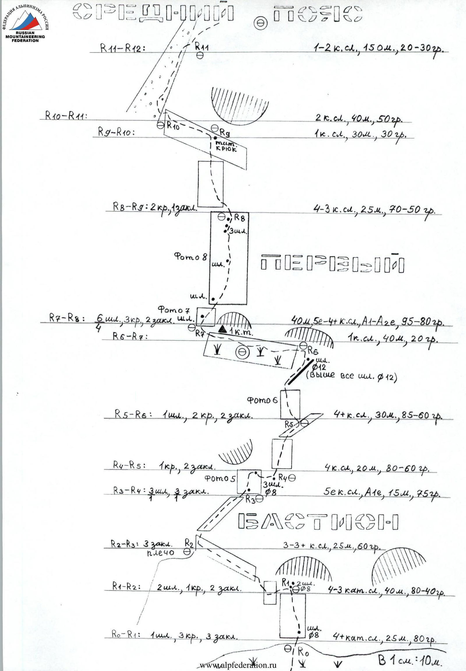
From the overnight grottos, return to the grassy slope leading under the South-West wall of Tbau N-W. Head towards the center of the wall's base, right of the 3B category route and left of the 4B category route.
The route begins 30 m below the left "eye" formed by a small grotto. From the overnight stop, 20 minutes.
R0–R1: 8 mm bolt with an eyelet is hammered 3 m above the ground. From it, 25 m up to a small grotto. Here, two more 8 mm bolts are hammered.
The entire section is 25 m, 4+ category, 80°.
R1–R2:
- From the station, traverse left and climb directly up to a ledge behind a flake – 5 m, 4 category; 80°.
- Further along the ledge left for another 35 m; 3 category, 40°, to a shoulder on the wall.
R2–R3:
- From the shoulder, climb directly up along an inclined ledge under a smoothed wall. Section is 25 m, 3-3+ category, 60°.
R3–R4:
- At the base of the wall, an 8 mm bolt with an eyelet is hammered.
- From it, under overhanging rocks, climb 10 m; A1e; 5 category, 75° to the next identical bolt.
- From it, traverse right 5 m, 5 category, 75° to the next 8 mm bolt.
FRIENDS are required for passage. No cracks; rocks are heavily smoothed.
R4–R5: Climb directly up the wall 15 m, 4 category, 80° to a ledge, then right up 5 m, 4 category, 60°.
R5–R6: Climb left up the wall 15 m, 4+ category, 85° to the wall's inflection. Further along a rocky ridge, exit to a ledge: 15 m, 4 category; 60°. On the right is a "sleeping" piton.
R6–R7: Along the ledge left 40 m, 1 category, 20°. In the left part of the ledge, in a small grotto, is the 1st control tur. Overnight possible on the ledge.
R7–R8:
- Climb right up through a small cornice 6 m, 95°; 5 category, A1e.
- 3 m from the ledge, a 12 mm "sleeping" bolt without an eyelet is hammered.
- Here and further to the end of the route, all bolts are 12 mm "spits" without eyelets by "Petzl".
- Behind the cornice, 3 m further, another "spit".
- Climb directly up the wall with small ledges.
- After 10 m, another "spit".
- After 30 m from the start of the section – slabs 5 m, 5 category, A2e, 80° – here, three "spits" are hammered.
- The entire section is 35 m; the middle part is 4+ category.
R8–R9: Climb left – up the wall, initially 4 category, then 3 category, to a ledge. The entire section is 25 m, 70–50°.
In the middle of the ledge, on the right, an old ice hook – a titanium "carrot" – is hammered.
R9–R10: Along the ledge left and up to a couloir 30 m, 1 category, 30°.
R10–R11: Along the right side of the couloir, via rocks 2 category, 40 m, 50°, exit to the middle tier. Overnight possible. Ascent from the wall base: 200 m. We spent 20 climbing hours.
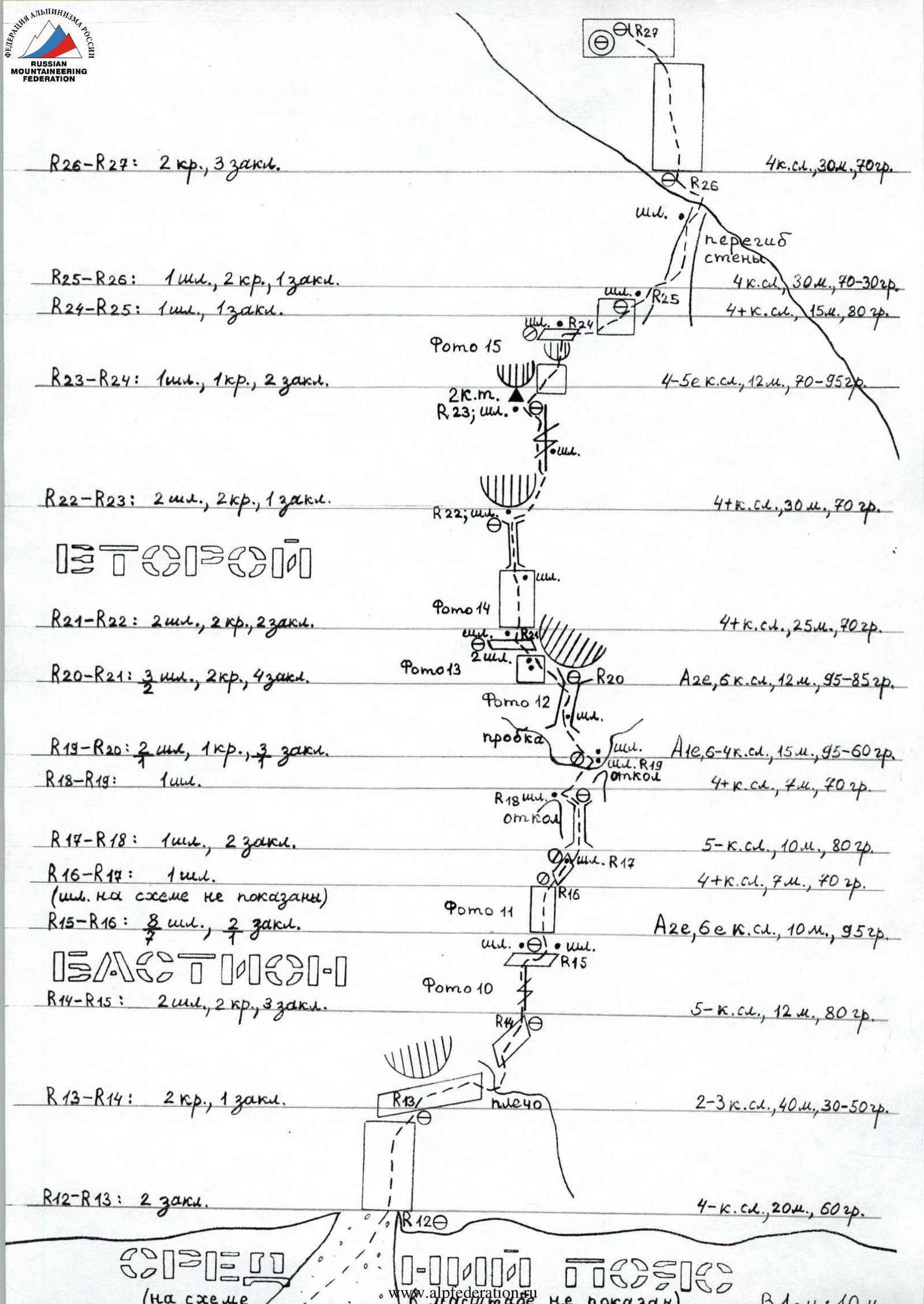
R11–R12: From the overnight stop, climb right up under the 2nd bastion. Head towards the wall base under a large triangular cornice with black streaks. Pass a narrow rocky ledge on the way to the 2nd bastion either at its narrowest part (10 m, 3 category) or bypass it on the right. The entire section is about 150 m, 1B category, 20–30°. At the end, traverse right into a couloir.
R12–R13: Ascend along a wide, grassy-scree couloir to the base of the 2nd bastion, then climb a wall 20 m, 60°, 4 category, to a ledge.
R13–R14: Along the ledge, right and up under overhanging rocks to a shoulder on the wall. From the shoulder, along a ledge, approach a gap – 40 m, 2-3 category, 30–50°.
R14–R15: Climb directly up a gap 12 m, 5 category, 80°. On the ledge, two "spits" are hammered, left and right.
R15–R16: Along a monolithic wall, left of an overhanging crack with destroyed sides, climb directly up to artificial climbing aids – 10 m, 6 category, 95°, A2e. The wall is monolithic. Here is a bolted route. Eight "spits" are hammered along the entire wall.
R16–R17: Along an inclined, smoothed ledge, right and up 7 m, 4+ category, 70°. At the end of the section, a "spit".
R17–R18: Climb directly up a chimney with an exit left to the top of a flake. Section is 10 m, 5 category, 80°. At the end, a "spit" is hammered.
R18–R19: Climb right and up under a plug – an overhanging rock sealing the chimney entrance. Exit between it and a small flake on the right. In the right part of the overhanging rock, a "spit". The entire section is 7 m, 70°, 4+ category.
R19–R20: 1 m above the station, another "spit" is hammered. Move left and up, then via a crack (FRIENDS), enter a chimney – "spit" – A1e, 5 m, 6 category, 95°. Further along the chimney with wedged stones, approach a niche under a cornice. Another 10 m, 4 category, 60°. Overnight possible in the niche for two.
R20–R21: From the niche, left and up along an overhanging crack between the cornice and the smoothed wall on the left. Initially, use FRIENDS. On the wall's inflection, two "spits" are hammered; further directly up to a ledge – another "spit". The entire section is 12 m, 6 category, 95-85°, A2e.
R21–R22: From the ledge, climb directly up, initially along the wall, then via a narrow chimney to a ledge under a cornice. "Spits" are hammered in the middle and at the end of the section. The entire section is 25 m, 4+ category, 70°.
R22–R23: Bypass the cornice on the right and climb up via a gap. At the end, move left into a niche under a cornice. Here is the 2nd control tur. "Spits" are hammered in the middle and at the end of the section. The entire section is 30 m, 4+ category, 70°.
R23–R24: From under the cornice, move right and along a slab approach overhanging blocks of destroyed rocks. The slab is 8 m, 4 category, 70°. Climb directly up via a crack between the blocks (FRIENDS) to a ledge – here, a "spit" is hammered. Another 4 m, 5 category, 95°.
R24–R25: Traverse right into a couloir. The traverse is initially along the wall, then along a ledge. Section is 15 m, 4+ category, 80°. At the end, a "spit".
R25–R26: Climb directly up the couloir through small walls. After 20 m, an inflection in the wall – exit to the 4B category route. 3 m before the inflection, on the left, the last "spit" is hammered. The couloir is 70°, 4 category. Further along a ledge, 1 category, pass another 10 m to a wall.
R26–R27: Climb directly up a wide wall 30 m, 4 category, 70° to the next wall. Overnight possible on the ledge under it.
R27–R28: Climb the next wall directly up: 40 m, 4 category, 70°.
R28–R29: From the next ledge, climb as high as possible, then move right around a corner into a chimney. The entire section is 25 m, 4 category, 60°.
R29–R30: Climb directly up, initially along the wall, then via a narrow chimney. Section is 50 m, 4+ category, initially 80°, then 60°. At the end, exit to a shoulder on the wall.
R30–R31: From the shoulder, along a ridge 2 category, 30–40°, 80 m, ascend to v. Tbau N-W (2980 m). The summit offers a panoramic viewpoint. Overnight possible. From the wall base to the summit, we spent 56 climbing hours, including preparations.
Descent from the summit into the Kurtatinskoye gorge – along the N-W slope and further down the southern slope of the N-W ridge to the grotto – 1B category route (2-3 hours).
Alternatively, descend via Tbau Main to the east into the Dargavskoye gorge – 1A category path (3-4 hours).
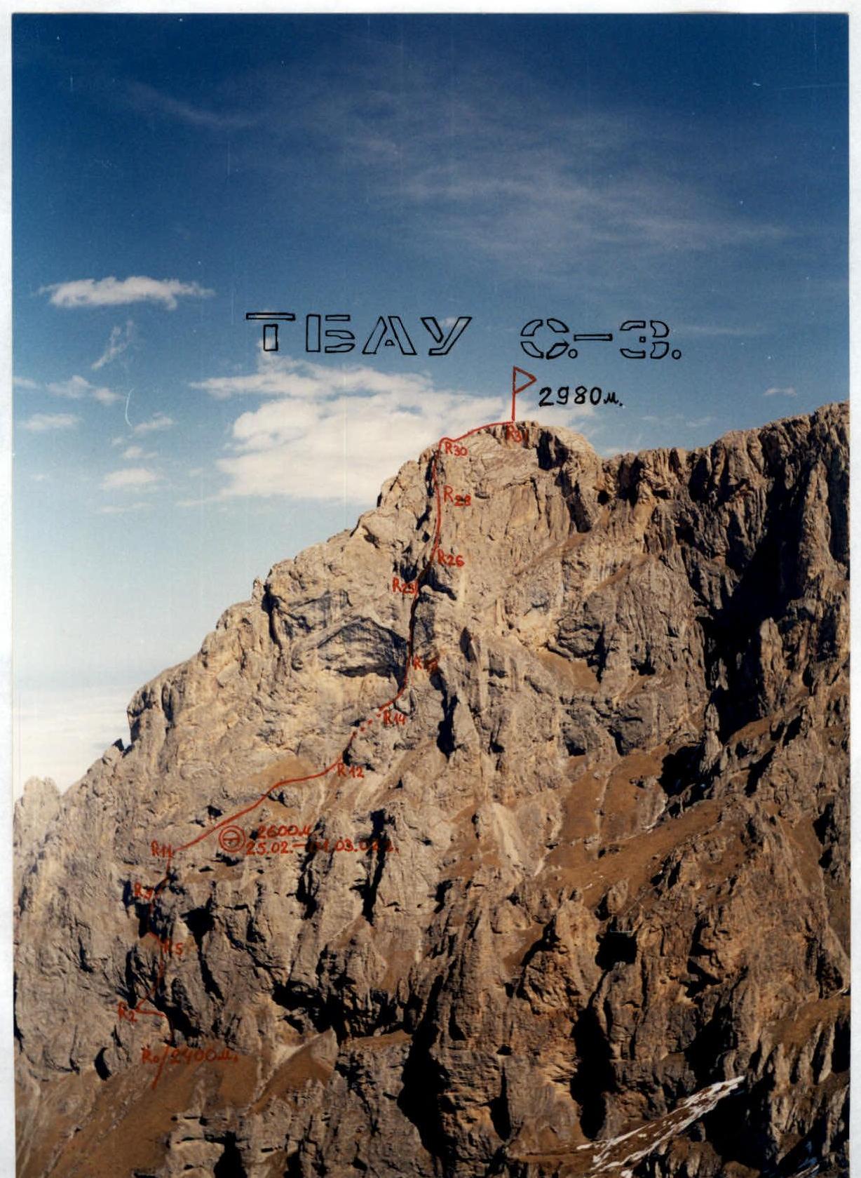
Photo 4. Technical photo of the route. October 2000. Photo taken from a height of 2781 m – on the South-West ridge of Tbau Main.
Group of rescuers from the North Ossetian Republican Search and Rescue Service of the EMERCOM of Russia "2" ______ 20__ at ______ while ascending to the summit via the "____" category route, consisted of:
- leader ________
- participants: ________
- Weather conditions: ________
- Further path started: "2" ________ 20__ at ______
- Along the route ________
- Note left by the group led by: ________
- from "____" ________
- Ascent leader ________ (signature)
Note from the Summit


Photo 5. Passage of section R3–R4 (start of the section). February 22, 2002.
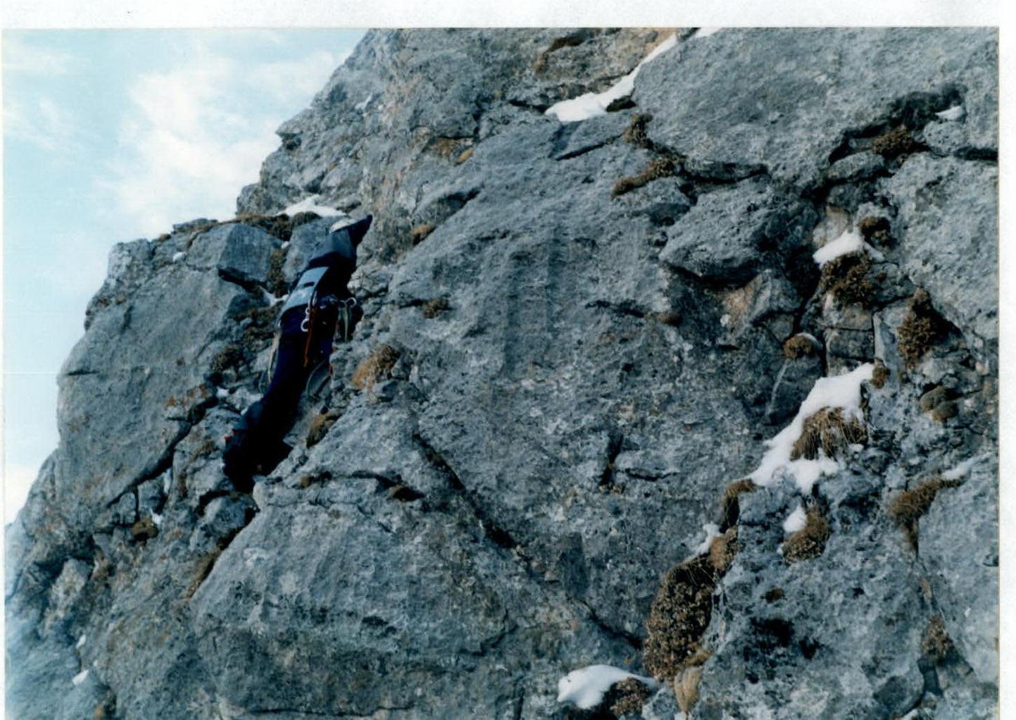
Photo 6. Passage of section R5–R6 (start of the section).
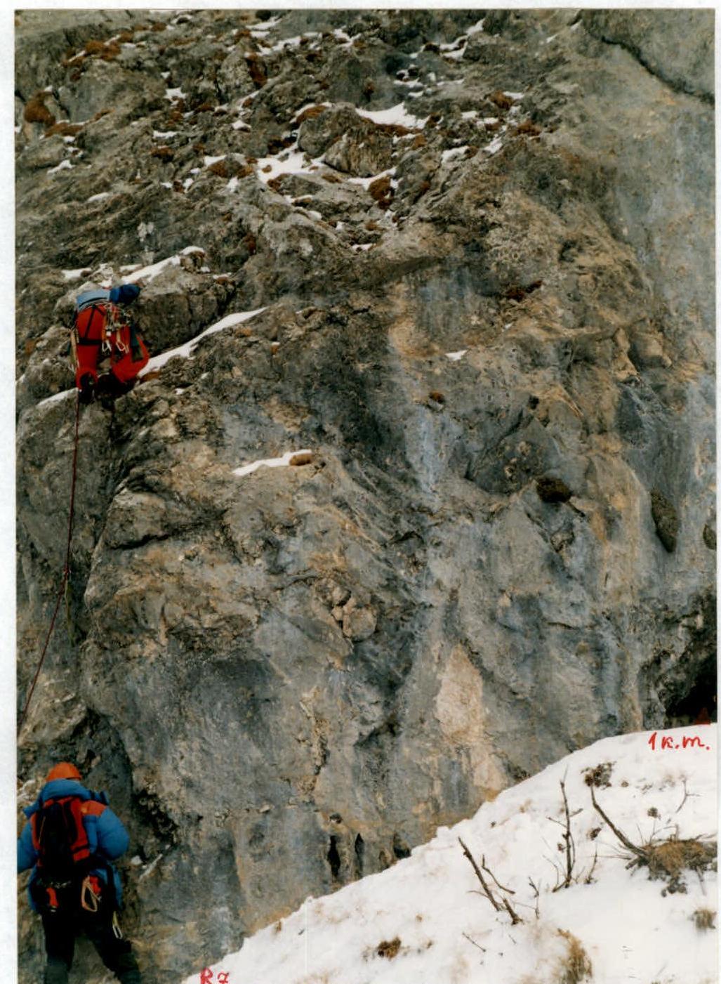
Photo 7. Passage of section R7–R8 (start of the section).

Photo 8. Passage of the middle part of section R7–R8. February 23, 2002.
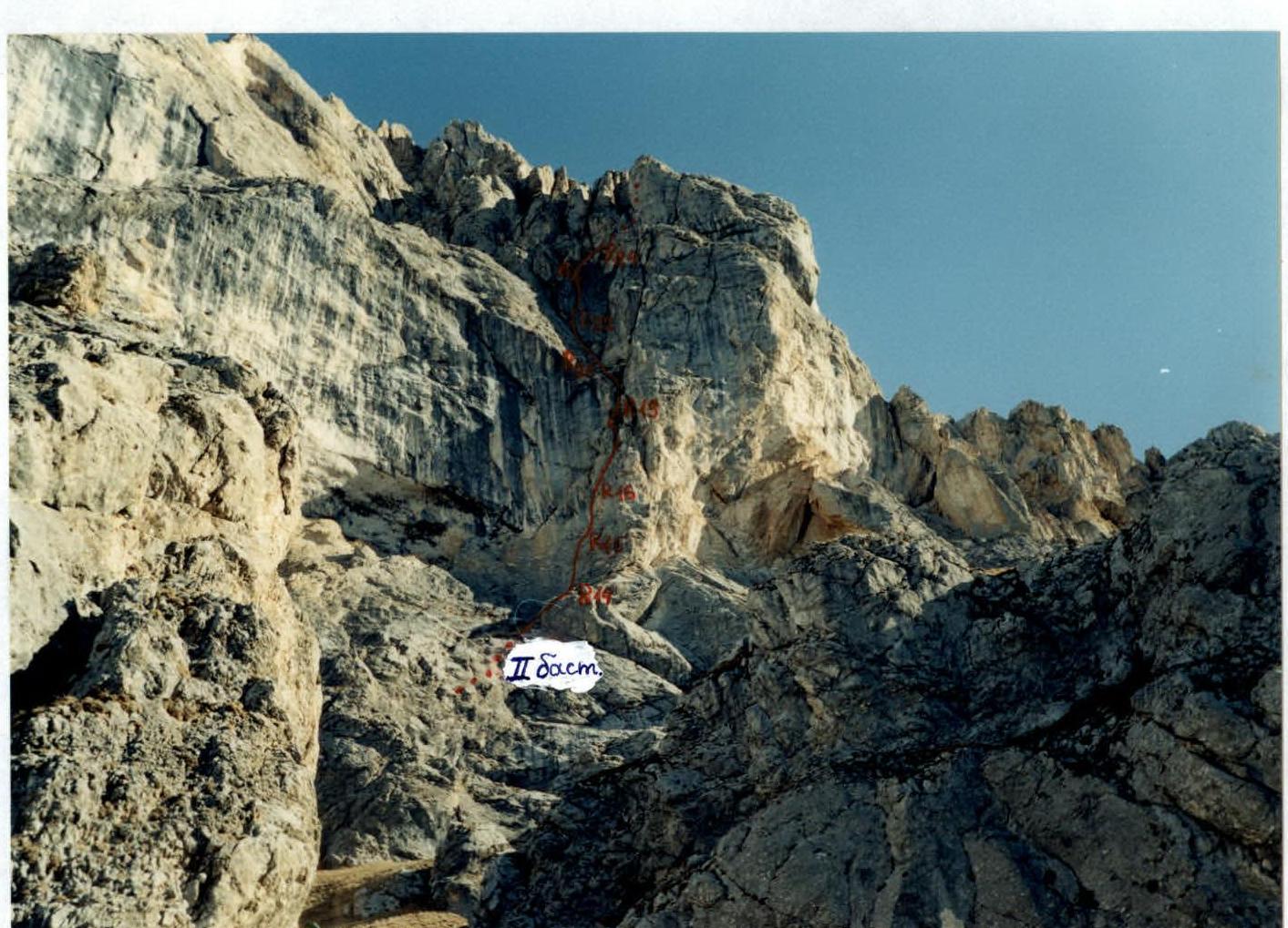
Photo 9. Second bastion of the South-West wall. First ascent route is marked. Photo taken from the 4B category route (top of the first bastion) by A. Glazov's group (leader) in October 1997.
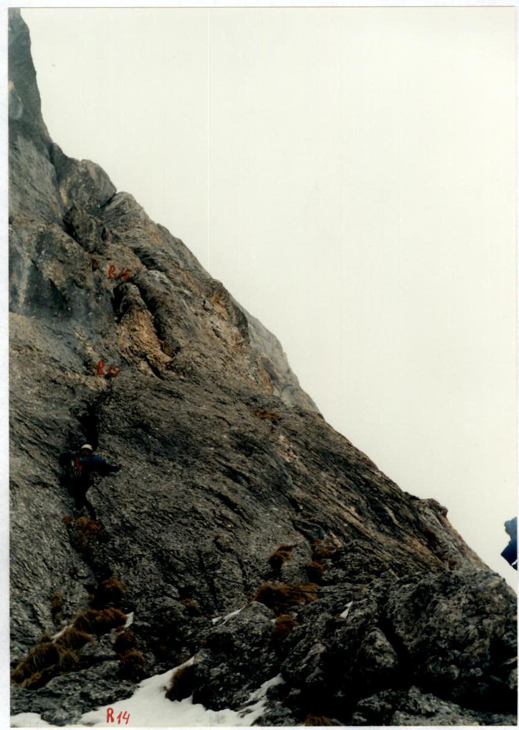
Photo 10. Passage of section R14–R15 (wall before snowfall). February 25, 2002.
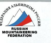
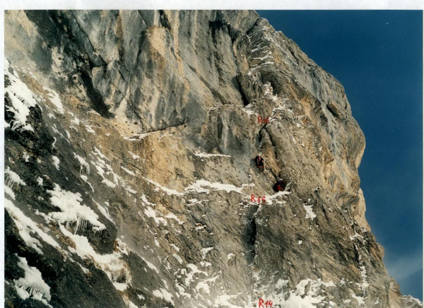
Photo 11. Passage of section R15–R16 (wall after snowfall). February 27, 2002.
Photo 12. Moving along the rope in a chimney. Upper part of section R19–R20.
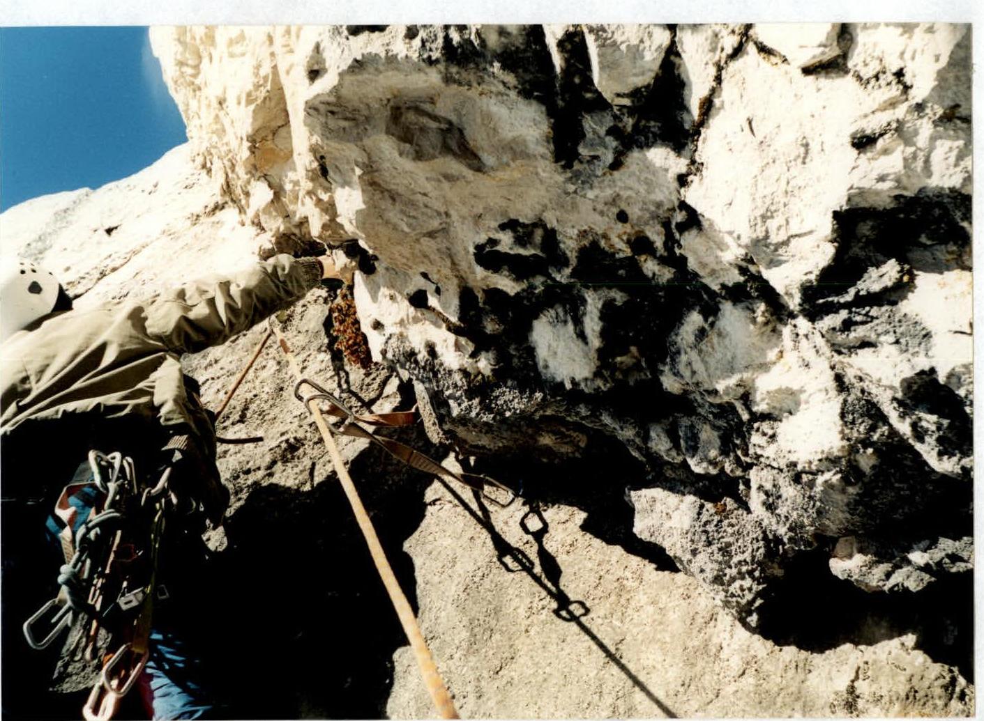
Photo 13. Passage of section R20–R21 (start of the section).

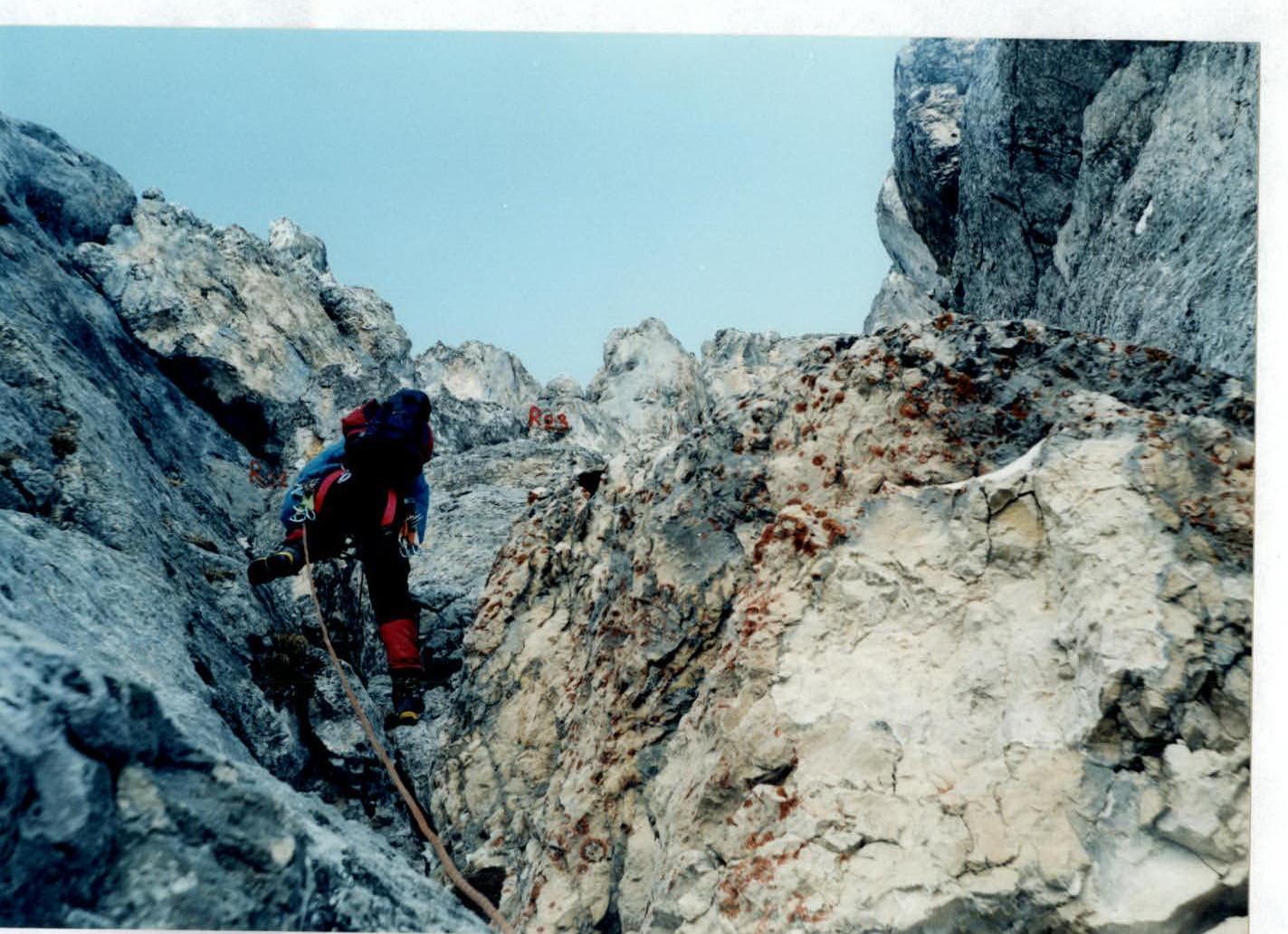
Photo 14. Moving along the rope at the start of section R21–R22.

Photo 15. Moving along the rope at the end of section R23–R24. Ascent through overhanging blocks.

Photo 16. Team on v. Tbau N-W. March 1, 2002.
Conclusions and Recommendations for the Route
The route we've climbed, in our opinion, corresponds to the 5B category due to the number and complexity of key sections.
The length of sections with 5 and 6 category complexity is 79 m. Approximately 35 m require artificial climbing aids. Compared to the adjacent 4B category route, our route is significantly more challenging (we climbed the 4B route in December 2001). As of now, the "via cornices on the South-West wall" first ascent route is the most challenging in the Rocky Ridge within the Republic of North Ossetia–Alania.
The route is recommended to be climbed from November to May when there is snow on the approaches and on the wall's ledges. At other times, a large amount of water must be carried due to the multi-day nature of the route, and the wall is dry from June to October (sometimes until December).
For the route, it's necessary to bring eyelets for spits (at least 5 pcs.). It's advisable to have at least 5 bolt pitons, as spits are hard to find on the wall, and the rocks are monolithic with few cracks.
Additionally, besides regular pitons and stoppers, it's necessary to have FRIENDs.
Receipt for the payment of the entrance fee for participation in the Championship.
| 362035, Vladikavkaz, PO Box 35, bld. 1 | |
|---|---|
| INN: 1504002168 | |
| Zav. number: 981027 | |
| Reg. number: 102 | |
| Check number | 24853 |
| 21.05.2002 | 9:31 |
| Cashier GERASIMENKO E.F.-V | |
| CHECK SERVICES number | 6005 |
| Claim period 6 months. | |
| TRANSFER | |
| POSTAL № 0136 | |
| 119992, MOSCOW | |
| TO: Shatayev V.N. | |
| TRANSFER AMOUNT | 312.00 ₽ |
| TRANSFER FEE | 24.96 ₽ |
| TOTAL | 336.96 ₽ |
| Cash | 400.00 ₽ |
| CHANGE | 63.04 ₽ |
Protocol №14
Meeting of the Classification Commission of the Alpine Federation of the Republic of North Ossetia–Alania
- Considered the report on the first ascent to v. Tbau N-W (2980 m) via cornices on the South-West wall. The route was climbed in February 2002, within the framework of the CIS Alpine Championship, technical class, led by Master of Sports in Alpinism Egorin S.V.
- Resolved:
- to petition the Classification Commission of the Alpine Federation of Russia to assign the 5B category to this route.
May 15, 2002.
Chairman of the Classification Commission: Yu.V. Levkovsky
Members of the Classification Commission:
- V.P. Gudenko
- K.B. Khamitsaev
- V.T. Rodionov
Comments
Sign in to leave a comment