
Ascent log.
- Ascent category: rock. 2.7.1
- Ascent area: 2,8; Caucasus: Kurtatinskoye gorge.
- Summit, route: Mt. Tbau-khokh (2980 m); via the Southwest wall.
- Estimated difficulty category: 5A category; first ascent.
- Route characteristics: height difference — 500 m; length — 1200 m. Section lengths: 6 — 50 m; 5 — 210 m; 3-4 — 330 m. Average slope: 40°; wall section: 60°.
- Pitons hammered: rock — 34; chocks — 4; ice screws — none.
- Number of climbing hours (days): 23 (2)
- Number of bivouacs: 1st — on approach; 2nd — on the wall; 3rd — on descent.
- Leader: Glazov A. P. – Master of Sports
Participants:
- Abisalov A. D. – 2nd sports category
- Levkovsky Yu. V. – Candidate Master of Sports
- Stadeev N. G. – 2nd sports category
- Coach: Levkovsky Yuri Vasilyevich
- Departure to the route: November 8, 1997; return to bivouac: November 9, 1997.
- Organization: KAM FSR RSO-A
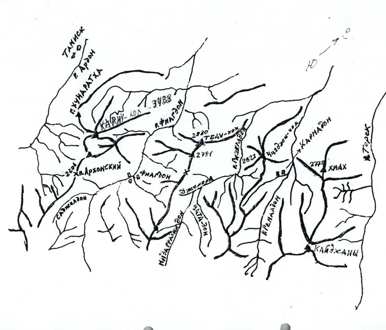
Brief overview of the ascent area
The ascent area is located in the Skalisty Range of the Central Caucasus between Mt. Kariu-khokh (2780 m) to the West and Mt. Chindjen-khokh (2823 m) to the East, between the basins of the Fiagdon and Gizeldon rivers and is territorially part of the Republic of North Ossetia.
Mt. Tbau-khokh (2980 m):
- composed of limestone rocks;
- – in the upper part – dolomites;
- often visited via a simple route from the South from the village of Fasnal;
- considered a sacred mountain by the local people.
Approach description
From Vladikavkaz, drive through the village of Dzuarikau, then along the Kurtatinskoye gorge to the "Metallurg" pioneer camp – 1 hour 30 minutes. From here, cross the Fiagdon River by bridge, move along the tractor road, which after 30 minutes leads to a gorge stretching along the Northwest ridge of Mt. Tbau-khokh and leading to a pass between Mt. Tbau-khokh and Mt. 2781 m, from which you can descend to the village of Fasnal. The road leads to the right (orogr.) slope of the gorge and soon disappears. Then move along the grassy slope on this side. After 2 hours, approach the dry riverbed, cross to its right side and move along the steep grassy slopes to a wide grassy-scree couloir, which goes left from the riverbed and leads to the 0-3 wall of Mt. Tbau-khokh in its left part.
In the upper part, where the couloir widens, there are two small grottos on both sides, a bivouac site. No water, in spring and autumn – snow. From the bridge, 5–6 hours.
Tbau-khokh via the Southwest wall
Along destroyed rocks of medium difficulty, reach a convenient, large ledge overgrown with grass. Then directly upwards along a steep 75° wall, 45 m – difficult climbing, piton belay, reach a ledge.
Right along the ledge, medium difficulty, 20 m – piton belay, approach the overhanging wall. Then directly upwards, 15 m – very difficult climbing, requiring drilled pitons, reach a small inconvenient ledge, drilled piton belay, space for one person.
From the ledge, right and upwards:
- along a very difficult vertical wall, 30 m – piton and drilled piton belay;
- along a small couloir of medium difficulty, 15 m – reach a large convenient ledge.
The ledge leads to a cave, where a control cairn is built. Then right:
- bypassing the cave along a simple ledge, 50 m;
- along a ledge of medium difficulty, 40 m – reach a plateau-balcony.
There is a convenient place for an overnight stay. Along the plateau, 250 m – approach the right part of the wall. Along a system of ledges of medium complexity, partly difficult – reach a small ridge, 60 m.
Along the ridge of medium difficulty, 30 m – approach a bastion. Along the left part of the bastion – reach a ledge, 40 m – difficult climbing, piton belay.
Right along a simple ledge – approach an overhanging wall, possible bivouac. Then right and upwards along the wall, difficult, psychologically complex climbing, 40 m – piton and drilled piton belay, reach a ledge.
Along a simple ledge right – bypass the overhang and along a small wall reach the next ledge, 10 m – medium difficulty. Along it left – approach a wall with a crack, 15–20 m.
Then:
- along a very difficult wall – reach a ledge, 40 m, chocks, pitons;
- along the ledge right – enter a couloir, 60 m;
- upwards along a simple couloir, 100 m – loose rocks, reach a ledge.
From the ledge:
- directly upwards along a wall above medium difficulty, 40 m;
- along a wall of medium difficulty, 40 m – reach under an inside corner.
Directly upwards along the inside corner, 45 m – above medium difficulty, piton belay, reach under a chimney. Along the chimney of medium difficulty, 30 m – loose rocks, reach the summit ridge.
Then along a simple ridge right – reach the summit, 100 m.
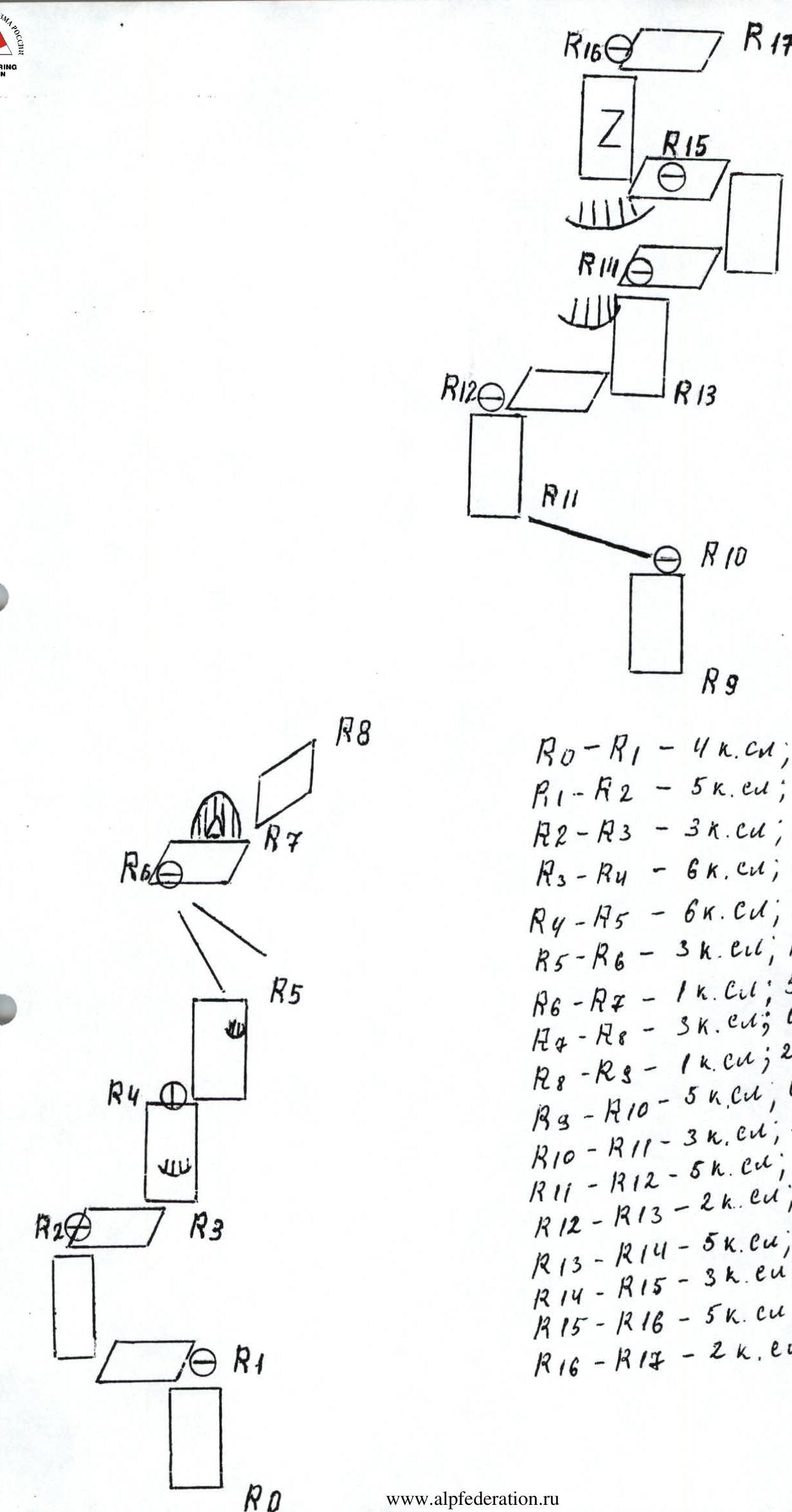
Section descriptions (R-schemes)
- R0–R1 – 4; 35 m; 60°
- R1–R2 – 5; 45 m; 75°
- R2–R3 – 3; 20 m
- R3–R4 – 6; 20 m; 92°
- R4–R5 – 6; 30 m; 90°
- R5–R6 – 3; 15 m; 50°
- R6–R7 – 1; 50 m; 20°
- R7–R8 – 3; 40 m; 35°
- R8–R9 – 1; 250 m; 30°
- R9–R10 – 5; 60 m; 60°
- R10–R11 – 3; 30 m; 40°
- R11–R12 – 5; 40 m; 70°
- R12–R13 – 2; 50 m; 20°
- R13–R14 – 5; 40 m; 75°
- R14–R15 – 3; 20 m; 50°
- R15–R16 – 5; 40 m; 80°
- R16–R17 – 2; 60 m; 20°
- R17–R18 – 2; 100 m; 45°
- R18–R19 – 4; 40 m; 65°
- R19–R20 – 3; 40 m; 50°
- R20–R21 – 5; 45 m; 80°
- R21–R22 – 3; 30 m; 60°
- R22–R23 – 1; 100 m.

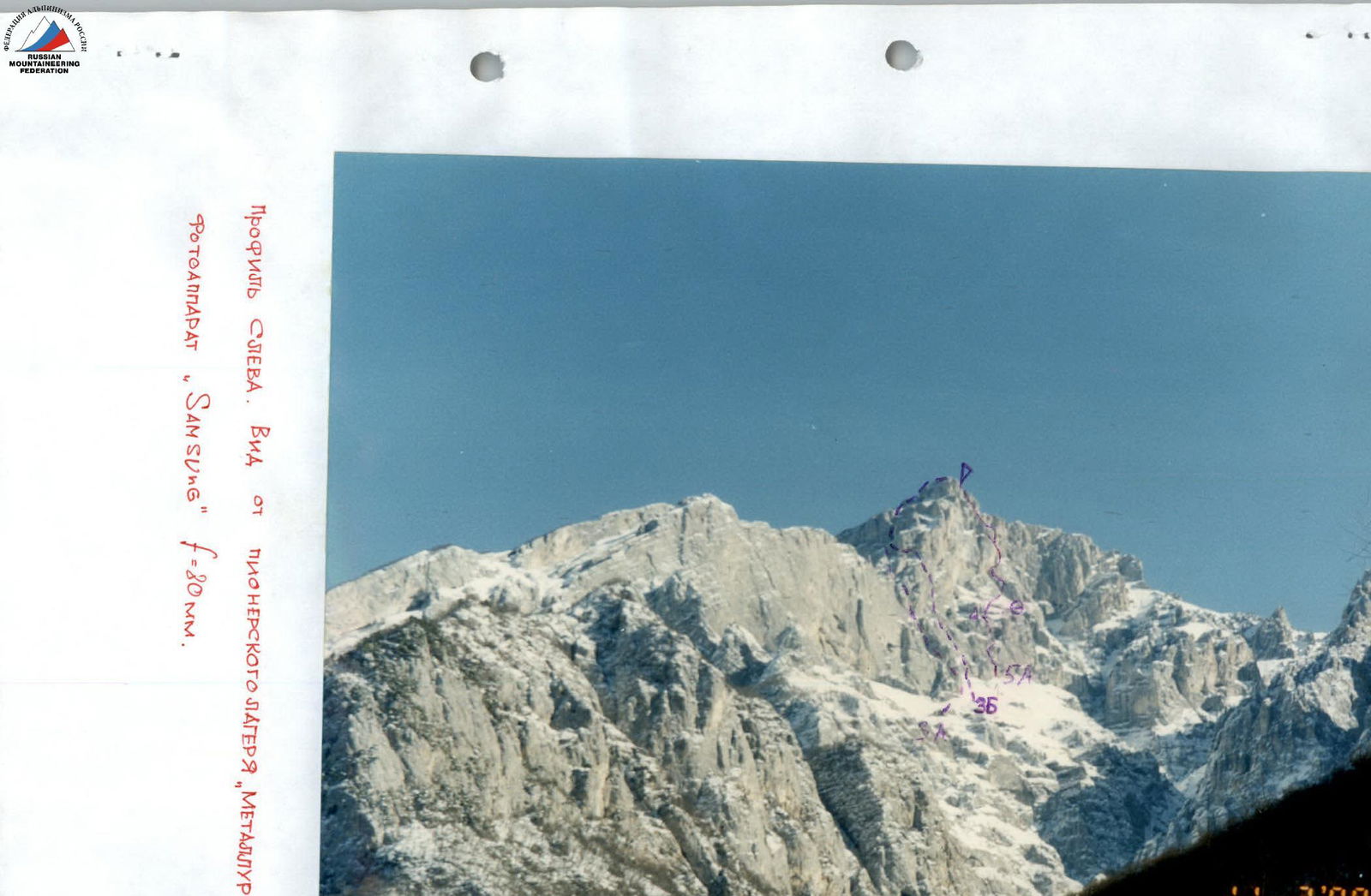
Left profile. View from the "Metallurg" pioneer camp. Camera "Samsung", f = 80 mm.
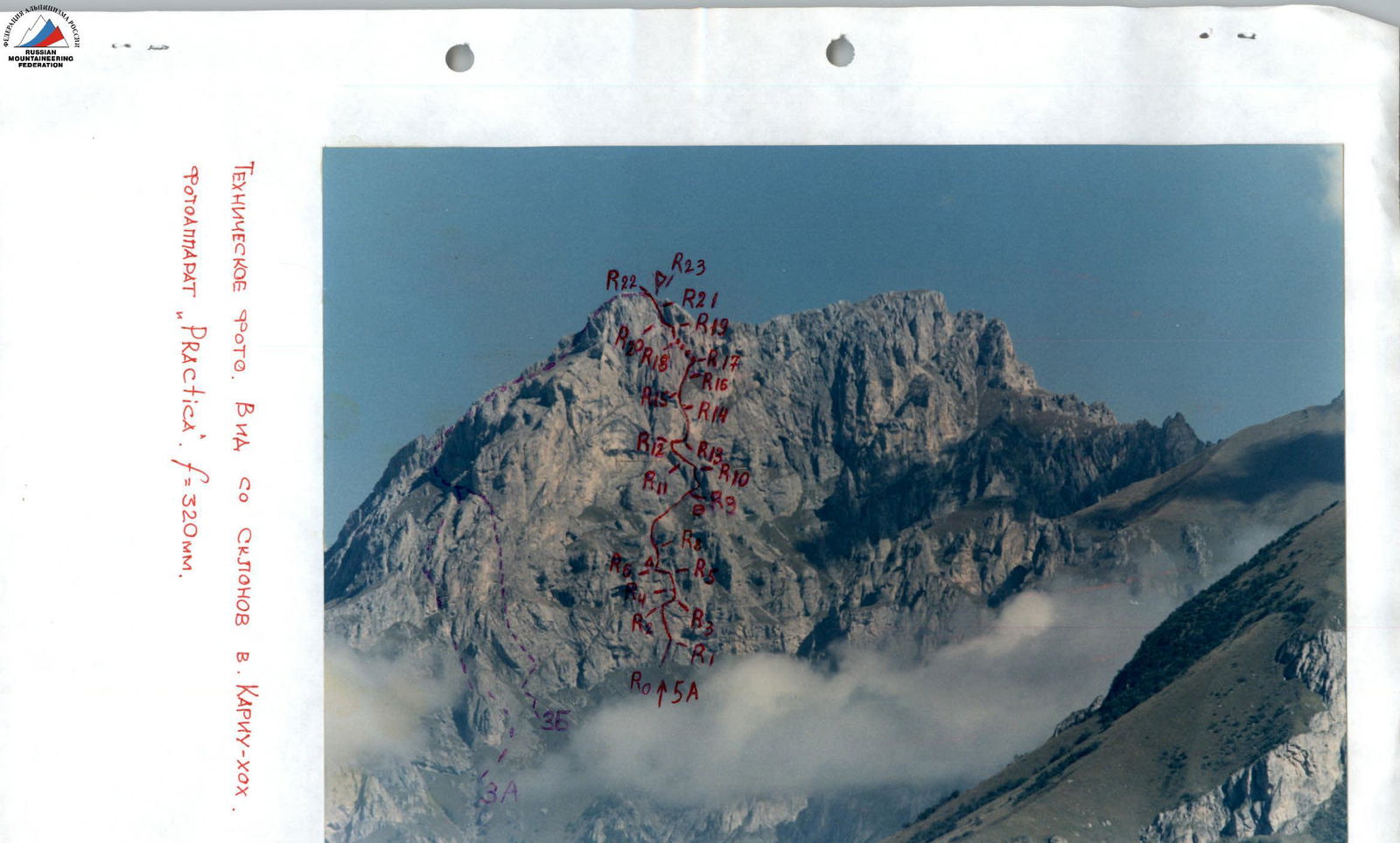
Technical photo. View from the slopes of Mt. Kariu-khokh. Camera "Practica", f = 320 mm.
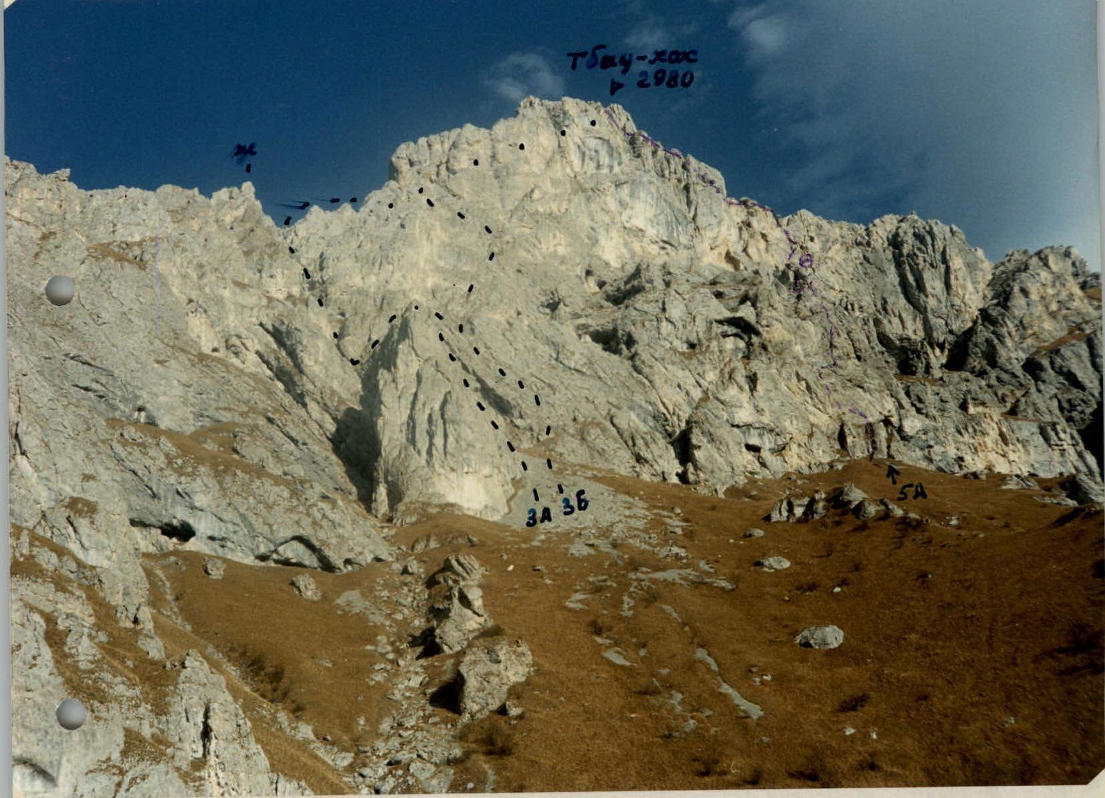
View from SW. October 1997.
Comments
Sign in to leave a comment