
- Climbing type: rock climbing
- Climbing area: 2.8: Caucasus: Kurtatin gorge
- Peak, route: Tbau-khokh peak (2980 m): from the South via the chimney and the North-West ridge
- Estimated category of difficulty: 3A category of difficulty: first ascent
- Route characteristics:
height difference — 400 m, route length — 750 m, length of sections:
- 4–5 — 40 m
- 3 — 200 m, average steepness:
- chimney — 60°
- ridge — 45°
- Pitons driven: rock — 5 pcs. screws — 3 pcs., ice screws — none
- Number of walking hours/days — 6/1
- Number of overnight stays: 1st — on the approach 2nd — on the list, bivouac in one place
- Leader: Levkovsky Yuri Vasilyevich — 1st category. Participants:
- Egorin Sergei Vladimirovich — CMS
- Ivanov Vitaly Valentinovich — CMS
- Glazov Alexander Petrovich — CMS. Coach: Proskuryakov Ruslan Pavlovich — MS.
- Start of the route — December 17, 1994
- Return to the bivouac — December 17, 1994
- Organization: KM FA RSO
Preparation for the ascent
During the preparation for the ascent, a reconnaissance of the approaches to the peak from the Kurtatin gorge was carried out, and an ascent to the nearby Chindjen-khokh peak (2823 m) was made. In both cases, photographs were taken, the route orientation was determined, and a preliminary assessment was made, as well as principles of radio communication were established.
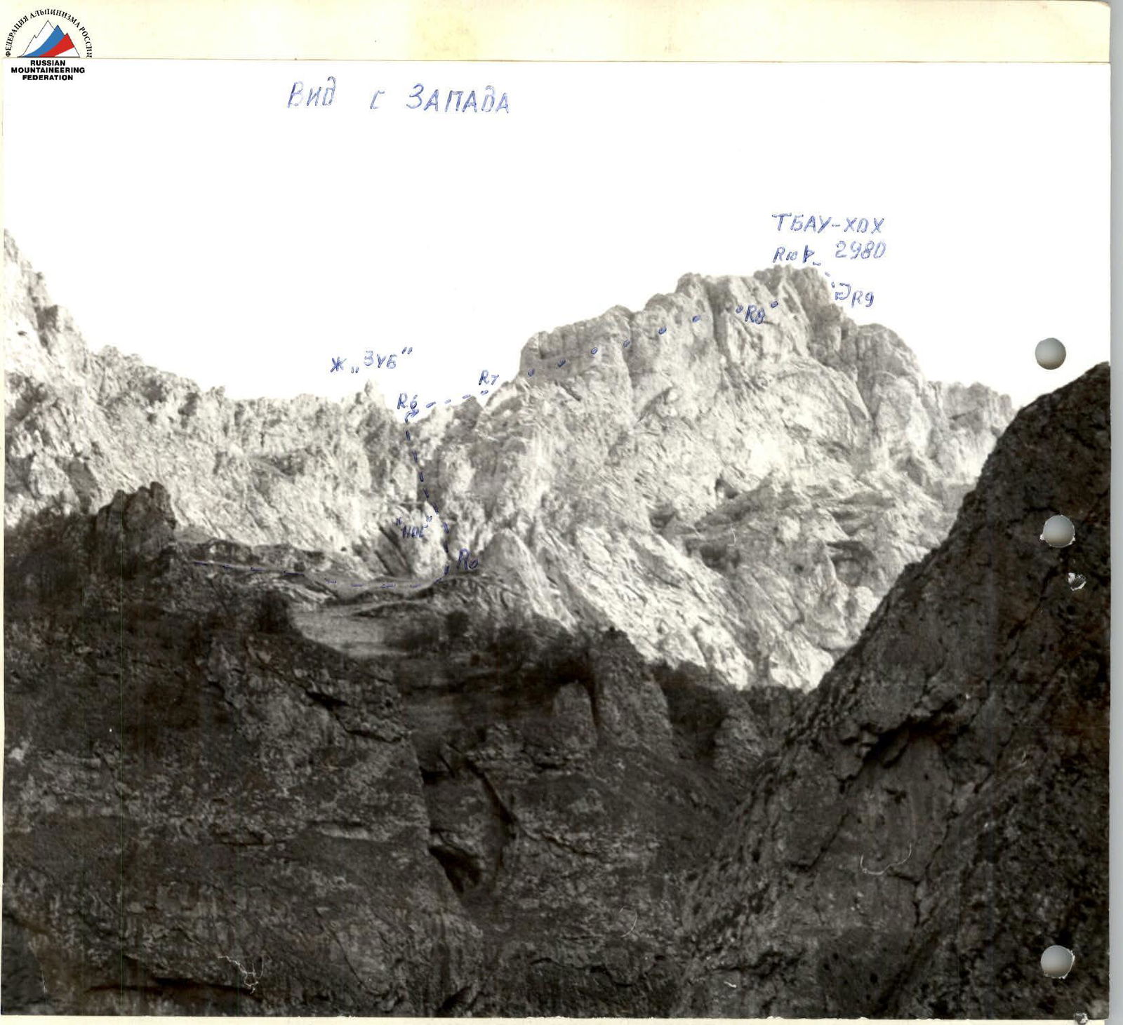
During the preparation, it was determined that it is best to establish communication with Vladikavkaz, starting from the exit to the North-West ridge and throughout the rest of the route, provided that a VHF radio station is used. There is no communication from the bivouac. View from the West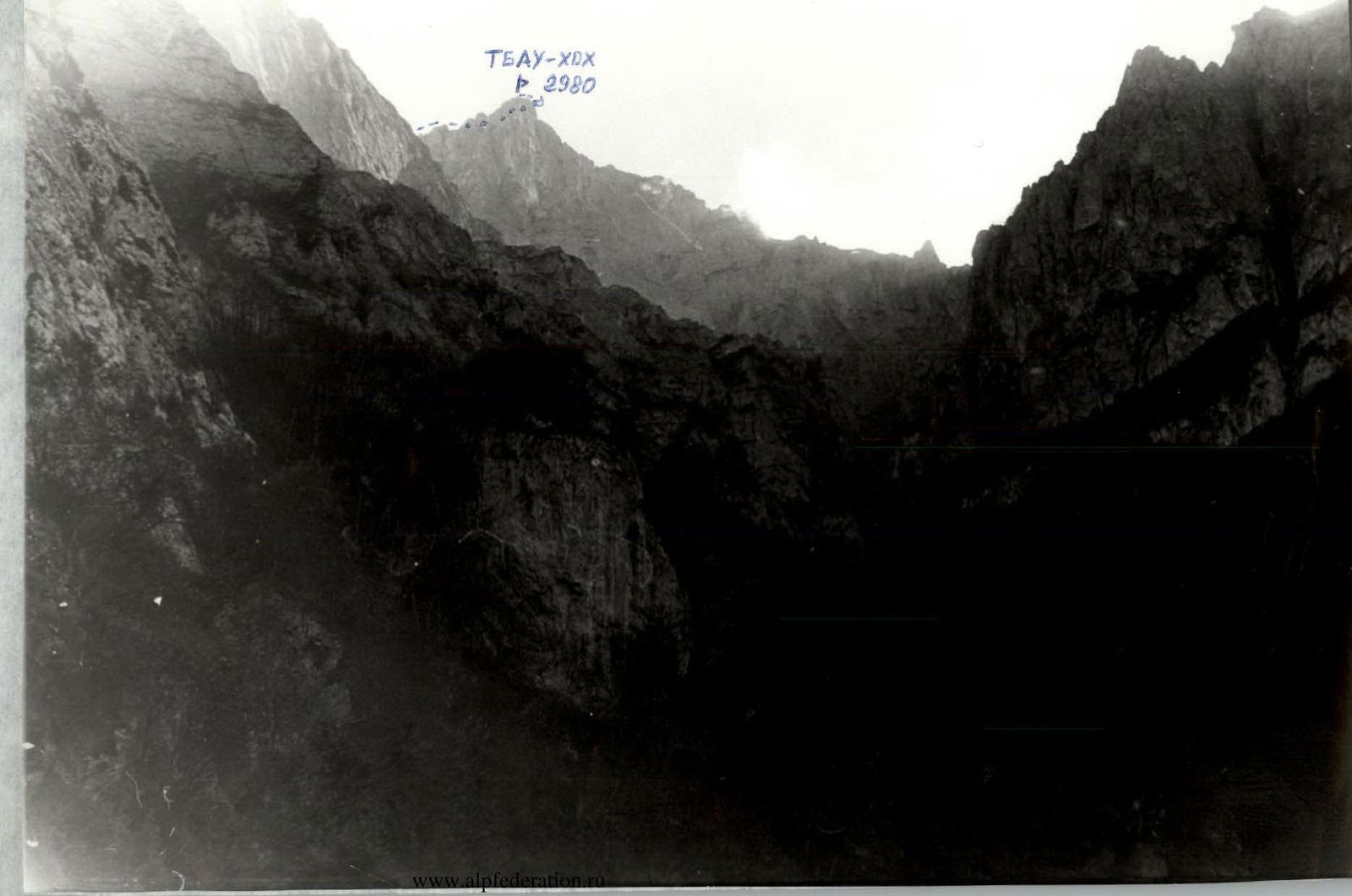
Brief overview of the climbing area
The climbing area is located in the Rocky Ridge of the Central Caucasus between the Karim-khokh peak (3438 m) to the West and the Chindjen-khokh peak (2823 m) to the East, between the Fiagdon and Gizeldon river basins and is territorially part of the Republic of North Ossetia.
Tbau-khokh peak (2980 m):
- composed of limestone rocks, with dolomites in the upper part;
- often visited via a simple route from the South from the Darqawc settlement;
- considered a sacred mountain by the local people.
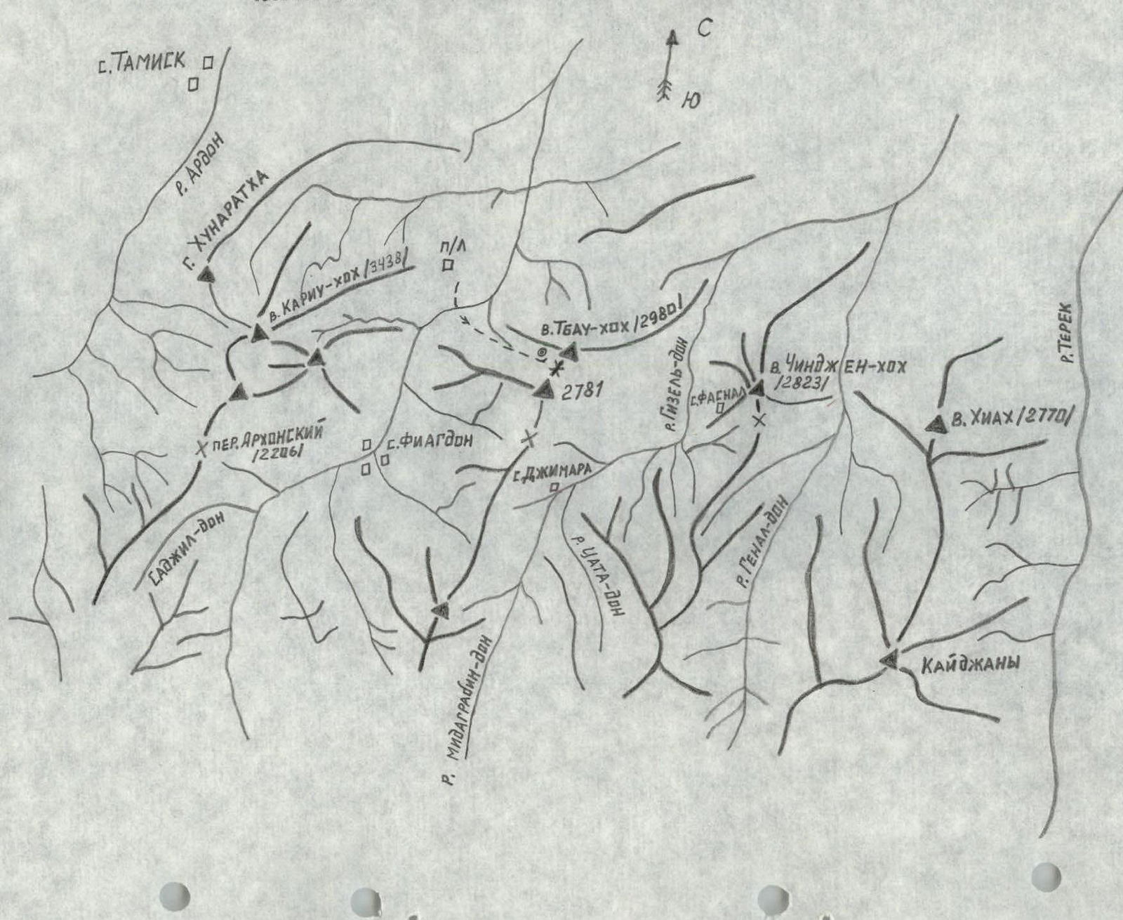
Approach description
From Vladikavkaz, drive through the Dzuarikau settlement, then along the Kurtatin gorge to the "Metallurg" pioneer camp — 1 hour 30 minutes. From here, cross the Fiagdon river over the bridge, move along the tractor road, which leads to a gorge stretching along the North-West ridge of Tbau-khokh peak in 30 minutes and leading to a pass between Tbau-khokh peak and peak 2781 m, from which you can descend to the Darqawc settlement. The road leads to the right (orographic) slope of the gorge and soon disappears.
Further movement is along the grassy slope of this side. In 2 hours, approach the rise of a dry stream bed, cross to its right side and move along steep grassy slopes to a wide grassy-scree couloir, which goes left from the stream bed and leads to the 3rd wall of Tbau-khokh peak on its left side.
In the upper part, where the couloir widens, there are two small grottos on both sides, bivouac. There is no water, and in spring and autumn, there is snow.
From the bridge — 5–6 hours.
Map of the Rocky Ridge (North Ossetia, scale 1:50 000)
 Tbau-khokh peak (2980 m): 3A category of difficulty: from the South via the chimney and the NW ridge
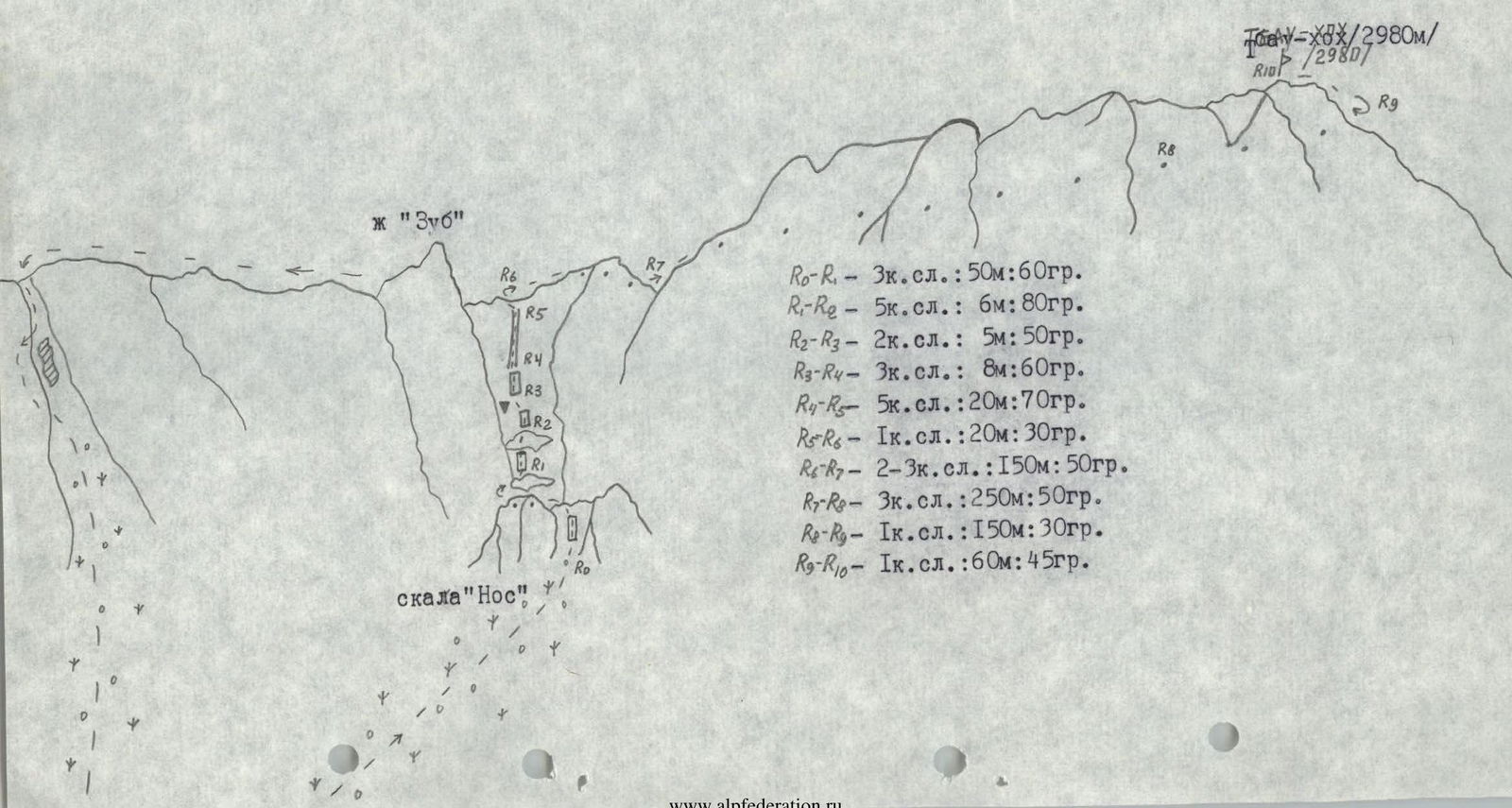
- R0–R1 — 3: 50 m, 60°
- R1–R2 — 5: 6 m, 80°
- R2–R3 — 2: 5 m, 50°
- R3–R4 — 3: 8 m, 60°
- R4–R5 — 5: 20 m, 70°
- R5–R6 — 1: 20 m, 30°
- R6–R7 — 2–3: 150 m, 50°
- R7–R8 — 3: 250 m, 50°
- R8–R9 — 1: 150 m, 30°
- R9–R10 — 1: 60 m, 45°
Route description
From the bivouac, move straight up along the grassy-scree slopes of the couloir to a large rock "Nos" (blocking the entrance to the chimney), go around it from the right, and approach the wall 3: 50 m, 60° — 1 hour. Climb the simple rocks of the wall (protection via ledges) and exit left onto a grassy saddle above the "Nos" rock.
From the saddle, descend traverse along the grassy slope to the beginning of the chimney, cross it, turn right, and move down a steep grassy slope, then along a 6 m wide ledge — to the first stage of the chimney.
On the left side of the chimney, climb the wall:
- 5: 6 m, 80° (very difficult, crumbly rock)
- traverse right, then up 2–3 m to a small cave
- from there, right-up along a ledge 4: 7 m, 50° — exit to the second stage of the chimney.
- Further movement is along a simple 5 m wall to a control cairn in a small depression on the left.
From the control cairn, move straight up the wall 3: 8 m, 60° to a chimney 5: 70°, 20 m, piton protection. Beyond the chimney, move up a gentle scree slope and exit onto the North-West ridge to the right of the "Palets" gendarme.
On the ridge, turn right and move along simple steep rocks 2–3: 150 m of the ridge, then along rocks 2–3 on the left (along the way) along the NW ridge 25 m (traverse) — exit under the summit bastion from the North side. Move straight up along 30° scree to approach the bastion rocks, then traverse left to go around the bastion and ascend to Tbau-khokh peak from the East side along grassy-rocky ledges. From the bivouac — 6–7 hours.
Descent from the peak follows the ascent route to the North side under the bastion, then 200 m down the ridge, then left-down to a rocky-scree shoulder, from which descend along a simple rocky-grassy slope to exit beyond the "Palets" gendarme onto the ridge to a large old cairn.
Further movement is down the NW ridge 200 m to a couloir, descend along it 60 m to rocky drops, from where move right to a rocky face, descend rappel 15 m along the wall, then left into the couloir, descend along a 5 m simple wall and down the couloir to the bivouac.
Descent from the peak — 2 hours.
Recommendations
The route is logical, objectively safe with a correct tactical ascent plan, recommended for training and sports groups.
In summer, there is no water at the bivouac and on the route.
Comments
Sign in to leave a comment