
Peak 25th Anniversary of SKGMI (~3840 m)
from the east 2B + 3A cat. diff.
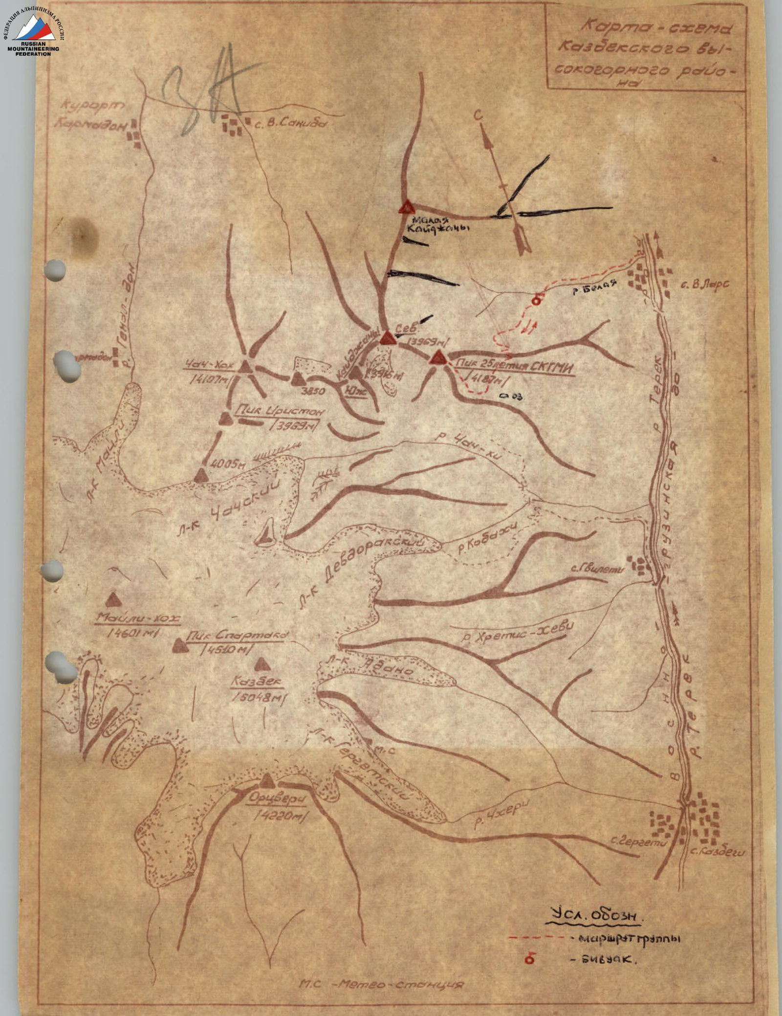
The peak is located at the extreme eastern end of the Central Caucasus, in the Kazbek group of peaks of the Lateral Ridge. The peak is the easternmost summit in the Northeast spur from the Kazbek Firn Plateau, consisting consecutively of the peaks: Peak "4005 m", Iriston Peak (3969 m), Chach-khokh (4098 m), Peak "3850 m", South Kaijany (3916 m), North Kaijany (3969 m), Peak 25th Anniversary of SKGMI (~3840 m). The massif of the peak and its eastern spurs separate the river basins - tributaries of the Terek: to the south - Koba-khi and upstream of its tributary - Chach-khi, to the north - the Belaya River. On the western and eastern slopes of the peak, one small dying cirque glacier has survived. The massif is composed mainly of clay shales, with separate outcrops of intrusive rocks. The slopes are significantly covered with talus. The first ascent was made by a group of climbers from the North Caucasus Institute of Mining and Metallurgy led by I. Suzhaev in 1956 via the simplest route from the Chach valley (2A cat. diff.). In subsequent years, ascents from the Chach valley were made repeatedly. In July 1971, a group of climbers from Ordzhonikidze (SO ASSR) led by R.P. Proskuryakov made the first ascent to the peak from the east, from the Belaya River valley. A description of the route is given below. From Ordzhonikidze, follow the Military Georgian Road to the village of Verkhniy Lars (31st km). Just before the village, the Belaya River flows into the Terek River from the right. Along the left (orographic) bank of the river, a pack trail ascends steeply to its upper reaches; after 2-2.5 hours of walking, you exit the gorge and enter a wide trough with numerous mudflows. In this area, there is a shepherd's hut where livestock is kept in the summer. It is possible to set up a bivouac in the area of the hut (2000 m above sea level). The ascent from here, with a descent to the Military Georgian Road and departure, takes a full day for a well-prepared group working intensively. If you have two full days, it makes sense to move the bivouac to a height of ~2800 m above sea level on the shoulder of the eastern spur of Peak 25th Anniversary of SKGMI. It is recommended to leave the bivouac early (at 3:00 AM). In the upper reaches of the valley, the peaks are visible (from right to left): Malaya Kaijany, North Kaijany, and Peak 25th Anniversary of SKGMI, whose eastern spur limits the Belaya River valley to the south. Move up the valley, keeping to the left (in the direction of travel) slopes. After 1.5 hours of walking, you pass the zone of mudflows, a birch grove near the slope of the mentioned spur, and a shale talus (2500 m above sea level). When starting the ascent to the spur, you need to reach the old pack trail and follow it, first bypassing the spur on the left, then climbing it along the trail's seracs. The hilly shoulder of the spur (~2800 m) is reached in 3-3.5 hours. On the shoulder, there are remains of a shale hut; from there, there is an excellent view of
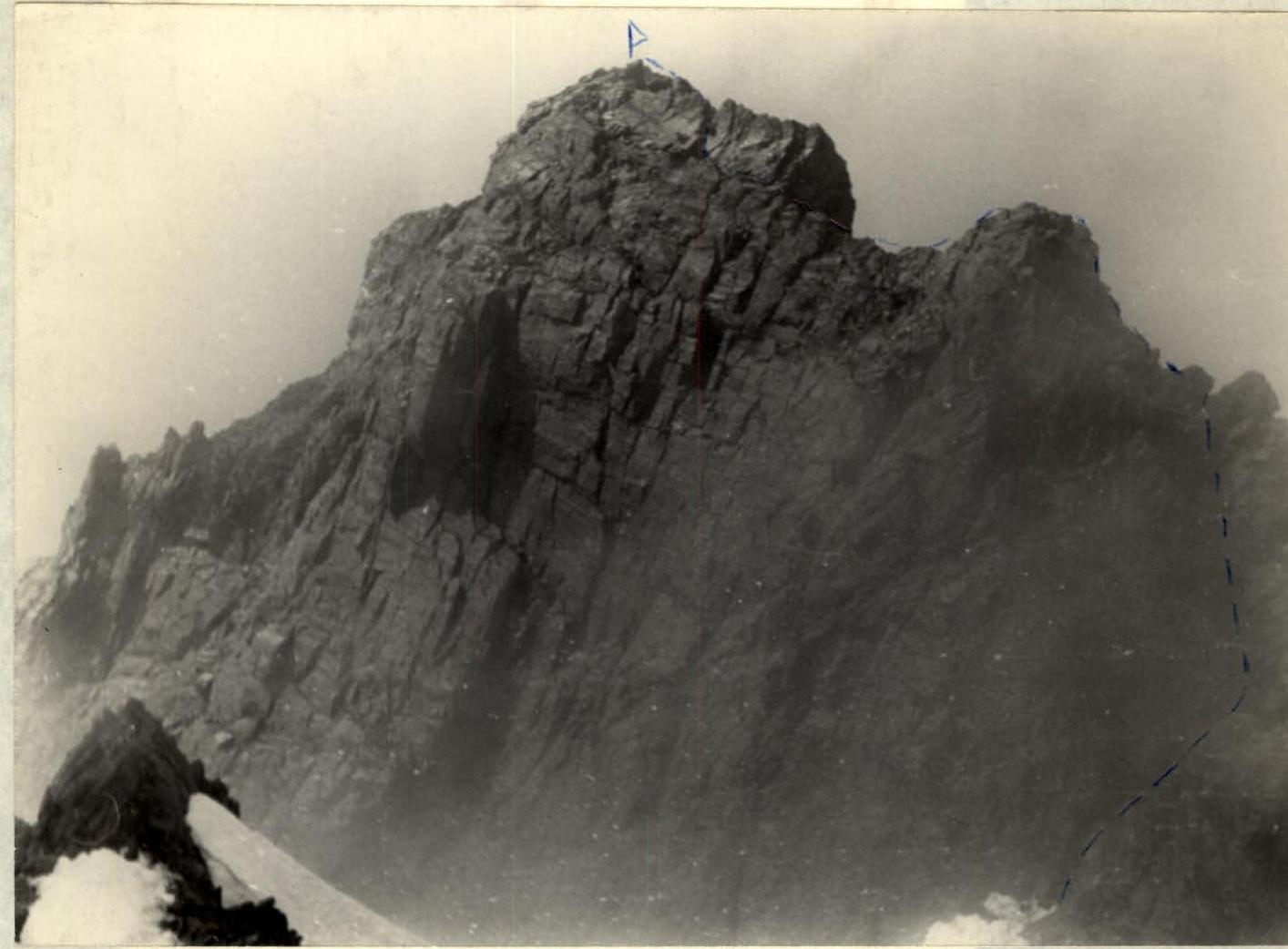
Photo 1. The summit tower of Peak 25th Anniversary of SKGMI. View from the pre-summit ascent.
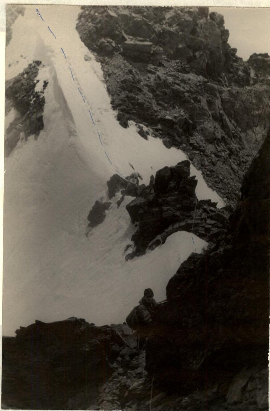
Photo 2. In the dip before the tower of the summit. View from the tower.
the dome of Kazbek and the trough-shaped cirque below with a lake on the opposite slope. Below the 3700 m mark, the Eastern ridge of the peak is dissected by the mentioned trough, forming two ridges. From the shoulder of the first ridge, you need to traverse to the similar shoulder of the second ridge, following the old pack trail, which is sometimes lost, along the slopes of the trough. The slopes are mainly talus, with some grassy areas. The ascent of the trail at the end of the trough leads to an area of chaotic moraine hills, which need to be climbed. You can bypass them on the left (in the direction of travel) along the snow in the pocket between the slope of the ridge and the moraine. After 1 hour of walking from the first shoulder, you reach the area of the stone remains of the second hut (3100 m). From here, a narrowing trough-shaped valley ascends steeply, heavily littered with moraine deposits alternating with snow slopes. Possibly, a small glacier has survived under the thick moraine cover in the trough. Moving up, after 1.5-2 hours of walking, you pass two steep moraine ascents composed of "live" stone debris. The ascent is laborious. Height 3400 m. On the moraines, some remains of the old pack trail are visible. At the mentioned height, there are remains of a third hut. Further up, a snow slope leads, stretching 150 m. In its upper part, it reaches a steepness of 40-45°, with ice felt under the snow in some places. Movement is in teams with mutual belay. The cliff of a rock island in the middle of the valley is bypassed on the left (in the direction of travel) along the ice and rocks of the edge (step-cutting is possible) with belay through ledges. After ascending to the "roof" of the island, move simultaneously along the snow, then along steep "live" talus with areas of broken rocks for 200 m, and reach the talus-covered, broken ridge at a height of approximately 3700 m. Following the ridge to the left, you overcome an ascent of broken, несложных rocks (30 m) with snow patches. Caution is necessary: the slope of the ridge drops steeply to the right into the Belaya River valley. Gradually flattening, the ridge leads to a wide rock-talus dome, with some snow patches. This is the junction of the two ridges of the Eastern spur of the peak. After walking 100 m along the wide ridge, you reach the pre-summit ascent (~3800 m), beyond which lies a dip in the ridge (photo 2), and from which there is a view of the rocky, imposing summit tower of the peak (photo 1). The descent into the dip along rocky blocks is slightly left of the ridge line (15 m), then along the narrow snow ridge to a gendarme in the middle of the dip (30-meter ropes are sufficient). The gendarme is overcome by climbing the rocks on its left wall, where a ledge is visible. Further, there is a snow "knife-edge" ridge, 10 m, abutting against the wall of a vertically standing giant rock block of the peak's tower, protruding towards the dip. From the snow, climb to the right along a slab and up rocks of medium difficulty to a niche (up to 10 m, 1 piton), where the first ascenders built a cairn on the route. To the right and up, climb rocks of a not clearly defined couloir, somewhat separating the mentioned giant block from the main massif of the tower. In the upper part of the wall (25 m high), there are many lying large blocks; climbing through them requires utmost caution. Belay through pitons and ledges. Rocks are of medium difficulty. In the upper part of the wall, move left and climb through the gap of the "claw" formed by the summit block and the ascent of the tower. A convenient place for belay through a ledge. From here, there are 40 m of climbing to the summit. Initially, to the left, bypassing the ascent of the tower, up - onto a shale ridge-"knife-edge", along it 5 m, and again climbing to the left, bypassing the summit ascent of the ridge; the climbing is psychologically difficult - on both sides, the tower drops with sheer walls; rocks are of medium difficulty to overcome. The rope occasionally lies conveniently in the gap between blocks, nevertheless, before the summit, 2 rock pitons are driven. The summit is rocky, with a platform for a small group. The most accessible slope descends to the west, from where the 2A cat. diff. route is laid. Height by altimeter ~3840 m. Overcoming the technically difficult section of the route - the dip and the tower - takes about 2.5-3 hours. From the bivouac to the summit will take about 10 hours of ascent. The descent along the described path to the Military Georgian Road will take 4-5 hours. The route is long and physically demanding, technically corresponding to 3A cat. diff.
Equipment recommended for a group of 4 people
- Main ropes - 30 meters long
- Rock pitons - 5 pieces
- Group carabiners - 3 pieces
The description was compiled by
 R. PROSKURYAKOV, Master of Sports of the USSR
Photo by R. Proskuryakov, December 24, 1971
R. PROSKURYAKOV, Master of Sports of the USSR
Photo by R. Proskuryakov, December 24, 1971

 To the description of the first ascent to Peak 25th Anniversary of SKGMI from the east 2B cat. diff.
The description was submitted to the Climbing Federation Classification Commission (USSR) in the spring of 1972. The description was sent for review to A. Kaurov, who delayed the inclusion of the route in the class table of peaks, citing the lack of a general view of the massif.
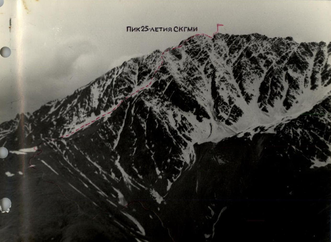
In the photo: General view of the massif of Peak 25th Anniversary of SKGMI from the northeast. The route of the first ascent from the east is marked. Telephoto by R.P. Proskuryakov.
Comments
Sign in to leave a comment