
The summit is located in the Tepli group of the Front Range of the Greater Caucasus, in the northern "Saw" of Kolota (4168 m), being the northernmost peak of the spur.
The first ascent to Pik Severny was made from the Tsaziu-kom gorge, with an exit to the eastern ridge of the Peak, on June 12, 1966, by a group of climbers from Ordzhonikidze, consisting of 7 people (1st category, the rest - higher category) led by V. Meshcheryakov, with R. Proskuryakov as the instructor-observer.
Day 1
From Ordzhonikidze, they drive by car along the Gizel highway to the village of Dzuarikau, after which they turn into the Kurtatinsky gorge. They pass through the villages:
- Lash,
- Khidikus,
- Khariskin and reach the bridge over the Tsaziu-don river, at the confluence of the latter with the Fiagdon river.
They ascend along the left bank of the Tsaziu-don river, following the trail, which after about twenty minutes of walking leads to a small bridge over Tsaziu-don. They cross the bridge and follow the trail along a fairly wide terrace of the gorge, overgrown with bushes and dwarf birches. After 2 hours and 30 minutes of walking along the trail along the river, they exit the bush zone and move along an alpine meadow. Near a small mountain lake, a bivouac can be conveniently set up.
Day 2
The start is early. Following the trail, they ascend along the riverbank to the moraine of the glacier and, near the slopes of Pik Severny, pass 200–300 m along one of the moraine "pockets". Then they turn right and ascend along quite large scree to a small glacier trough.
Then:
- They overcome the steep ascent of the loose frontal moraine of the glacier,
- They descend along the glacier (gentle, snow-covered, but completely safe) into the 6th trough,
- They exit to the right onto the eastern ridge of the Peak,
- They ascend along the 45-degree slope (snowy, partially icy, with sections of несложных rocks and large scree).
Having ascended to the eastern ridge (steeply dropping to the north with rock walls), they move, roped up, left along the ridge. From the moraine to the ridge, it takes about 2 hours and 30 minutes of movement.
On the ridge, they encounter five drops (ledges), their height being 20–25 meters:
- The first two - more gentle, are passed with mutual belay;
- The rest - with alternate belay, using outcrops and rock pitons with long blades.
Rocky sections alternate with sections of a sharp snowy ridge (alternate belay).
After the fifth drop, the ridge abuts a large "gendarme" about 50 m high. The "gendarme" is climbed along rocks of medium difficulty straight up to the middle, and then along a narrow ledge encircling it on the left (in the direction of travel) (along the fixed ropes).
Beyond the "gendarme" lies the massif of the Peak's tower, cut by a narrow steep couloir, extending for three rope lengths. The ledge leads to heavily (medium difficulty) destroyed rocks on the left (orographic) side of the couloir. The rocky sides of the couloir are steep, and the bottom, with an avalanche chute in the middle, is filled with snow, beneath which ice protrudes. The steepness of the couloir is 45–50°.
With alternate belay, they move up along the edge of snow/ice and rocks along the left side until the couloir narrows, where they climb up a wall (5 m high) to a knob, beyond which the couloir needs to be crossed, and then move along steep snow (up to 55°) along the right side of the couloir, for about one rope length. The snow leads to a highly destroyed 20-meter rocky ascent to the main point of the massif.
Movement along the rocky ascent must be very cautious - all dislodged stones will fall onto the route, into the couloir. When moving through the couloir, constant observation of the top is necessary. For belay in the couloir, five rock pitons are hammered in.
The summit is a sharp ridge, a jumble of "live" fragments, with no room for the entire group at the highest point. On all sides, the tower drops off with steep rocky slopes. From the "gendarme" to the summit, it takes about 3–3.5 hours of work.
The descent is along the ascent route; it is advisable to organize it in a sportsmanlike manner. The descent into the Tsaziu-kom gorge to the bivouac by the lake will take about 3–5 hours. From here, in 1.5–2 hours, one can reach the highway in the Fiagdon river gorge.
The return to Ordzhonikidze by car will take 2 hours.
Equipment recommended for a group of 4 people:
- Tent
- Sleeping bags
- Cooking utensils
- Food
- First aid kit
- Flashlights
- Spare batteries
- Axe
- Ropes
- Main ropes (30 m) - 2 pieces
- Rock pitons (with long blades) - 8 pieces
- Carabiners (group) - 6 pieces
- Repschnur for loops - 2 pieces
- Hammers - 2 pieces
The description was compiled by: V. Meshcheryakov R. Proskuryakov (1966)
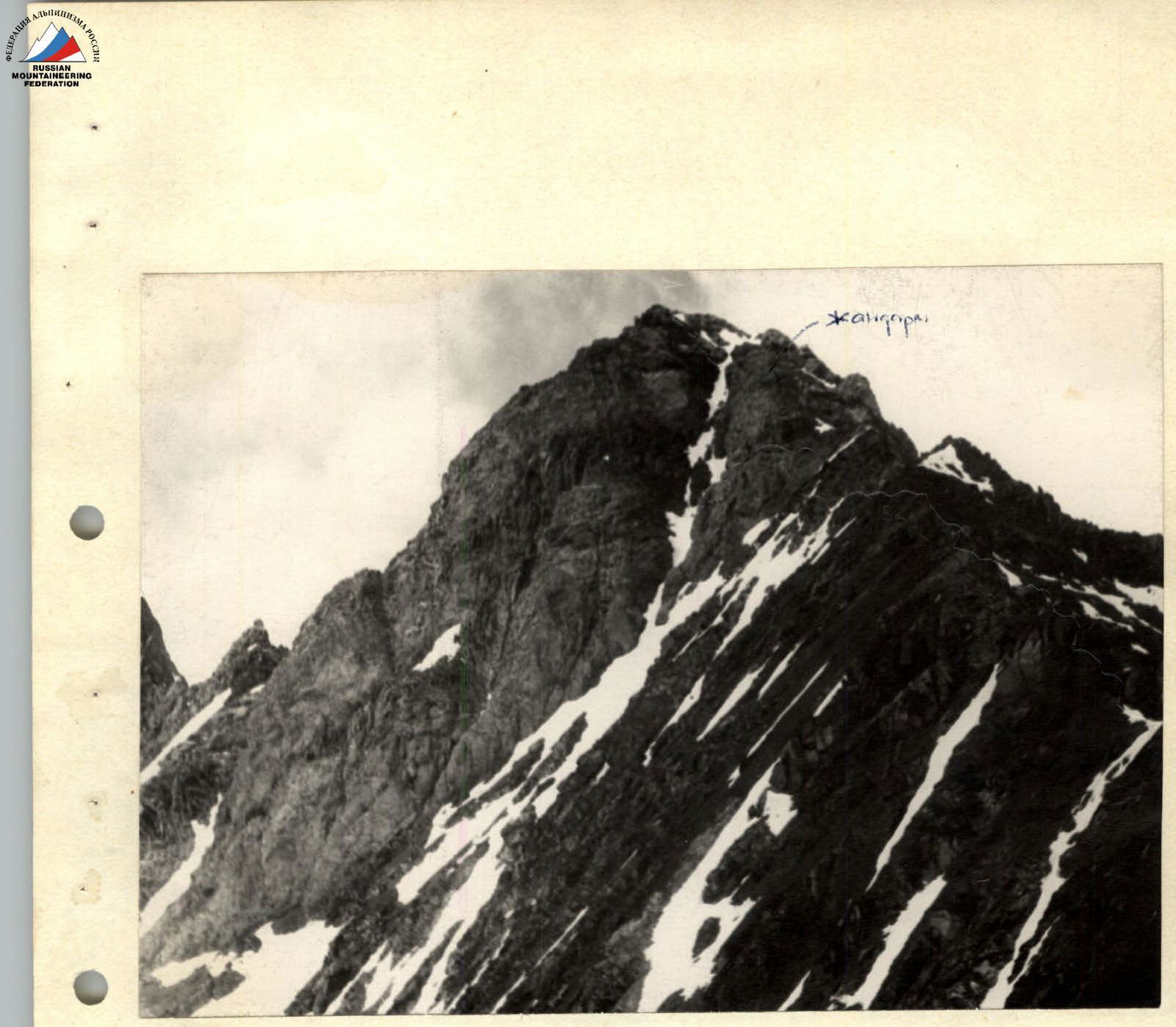
Pik Severny (3829 m)
View from the East Route along the Eastern Ridge, 3A category of difficulty Photo by R. Proskuryakov
Map-scheme of the Tepli area
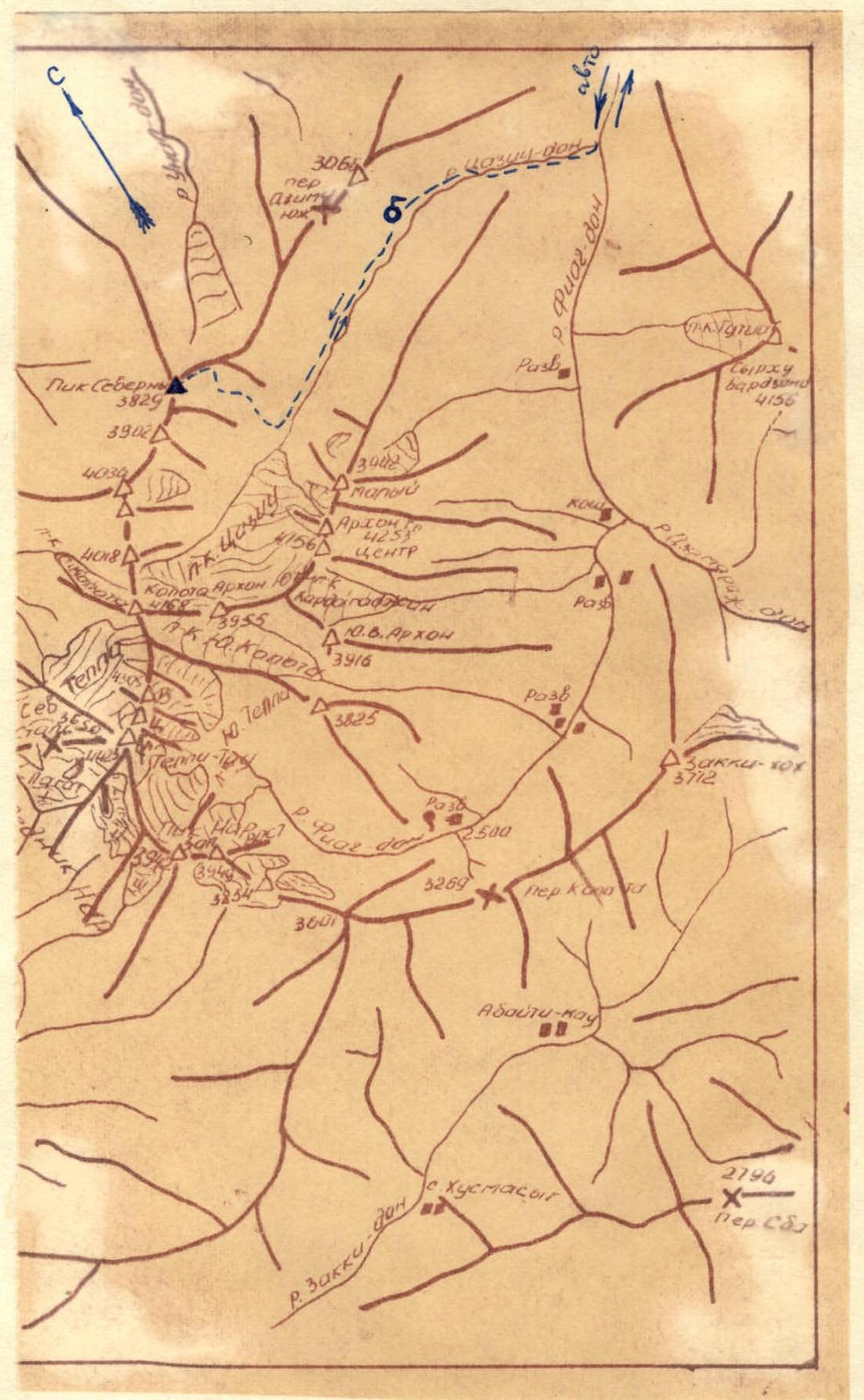
- — — — — route of the group
- — 5 — group bivouacs