Route Description
Ascent to the unnamed peak (in North Ossetia, it is referred to as пик Орджоникидзевской железной дороги, or Ordzhonikidze Railway Peak) via the north-northeast ridge, category П-Б difficulty (4005 m)
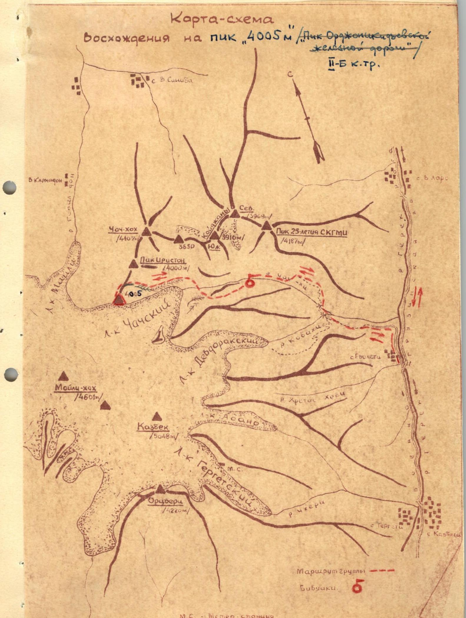
The peak is located in the watershed ridge (between the Genal-don and Чач-хи river basins), connecting the Казбекское плато (Kazbek plateau) to the south with пик Иристон (Iriston peak) and further to Чач-хох (Chach-khokh) to the north.
The peak was first ascended in May 1952 by a group from the Ordzhonikidze Road Council "Lokomotiv" led by Yu. Polyakov, who traversed Кайджаны (Kaidzhana) - Чач-хох (Chach-khokh) - Майли-хох (Maili-khokh).
As a standalone objective, the peak was first conquered on September 12, 1965, by a group of 9 climbers from the North Ossetian Council of the "Spartak" Sports Society, led by G. Eputaev and V. Kozlovsky (both 2nd sports category).
The ascent was made from the Чачское ущелье (Chachskoye gorge) with an exit onto the north-northeast ridge of the peak.
Day 1. The group drives by car to сел. Гвилети (Gvileti village), from where it takes no more than 1 hour on foot to reach the confluence of the Көбахи (Kobakhi) and Чач-хи (Chach-khi) rivers. After crossing the Көбахи river at the confluence and overcoming a steep ascent, they follow a trail into the right (Чачское, Chachskoye) gorge. Overcoming the "бараньи лбы ворот" ("ram's foreheads gates") via one of the shelves, they proceed up a grassy slope to a group of trees, where a trail begins. The trail leads into a wide couloir, crosses a stream, and then sharply turns right under the cliffs, following which it widens and leads to a shoulder forming the first "gates" of the gorge.
The distance from the confluence to the first gates takes around 1-2 hours on foot. The "бараньи лбы" ("ram's foreheads") should be traversed with caution, using gymnastic belay. From the pass point, there is a view of the Чачское ущелье (Chachskoye gorge) in the middle reaches of the Чач-хи (Chach-khi) river. Following a trail that traverses grassy slopes and several scree couloirs, it takes 40 minutes to reach the second "gates" of the gorge, a small rocky defile in the riverbed. The descent to the "gates" is via scree. The "gates" can be passed:
- via the left (orographic) slope of the gorge,
- or directly in the riverbed.
Before the "gates," there is a terrace on the right (orographic) bank (under the slopes of хребта Барт-Корт, Bart-Kort ridge), where it is possible to set up a campsite. From the second to the third "gates," it is more convenient to move along the trail in the riverbed. After 40 minutes of walking, they reach a widening of the riverbed before the third "gates," where it is convenient to set up a bivouac, and where a wide, trough-shaped couloir descends from the slopes of массив Кайджаны (Kaidzhana massif), originating from the троге ледника Кайджаны (Kaidzhana glacier trough).
Day 2
The third "gates" are passed on the left, following the grassy slope, adhering to the slopes of Барт-Корт (Bart-Kort). Upon ascending, they enter the Чечская котловина (Chechskaya kotlovina), a vast cirque filled with scree, moraines, and retaining in its southwestern part the tongue of the Чачский ледник (Chachsky glacier) flowing from the Казбекское плато (Kazbek plateau), from under which the Чач-хи (Chach-khi) river originates.
Above the third "gates" of the gorge, it is convenient to set up a base camp, from which ascents can be made to the peaks surrounding the Чачская котловина (Chechskaya kotlovina).
On the left bank of the gorge, a convenient exit to the гребень морены ледника Чеч (Chech glacier moraine ridge) is visible, leading to the контрфорс пика Орджоникидзевской железной дороги (Ordzhonikidze Railway Peak counterfort). From the base camp, on the right bank of the Чач-хи (Chach-khi) river, they descend to the river, traversing scree and gullies. After crossing to the left bank of the Чач-хи river (fording via stones), they ascend via a barely noticeable trail to a pronounced моренный гребень (moraine ridge).
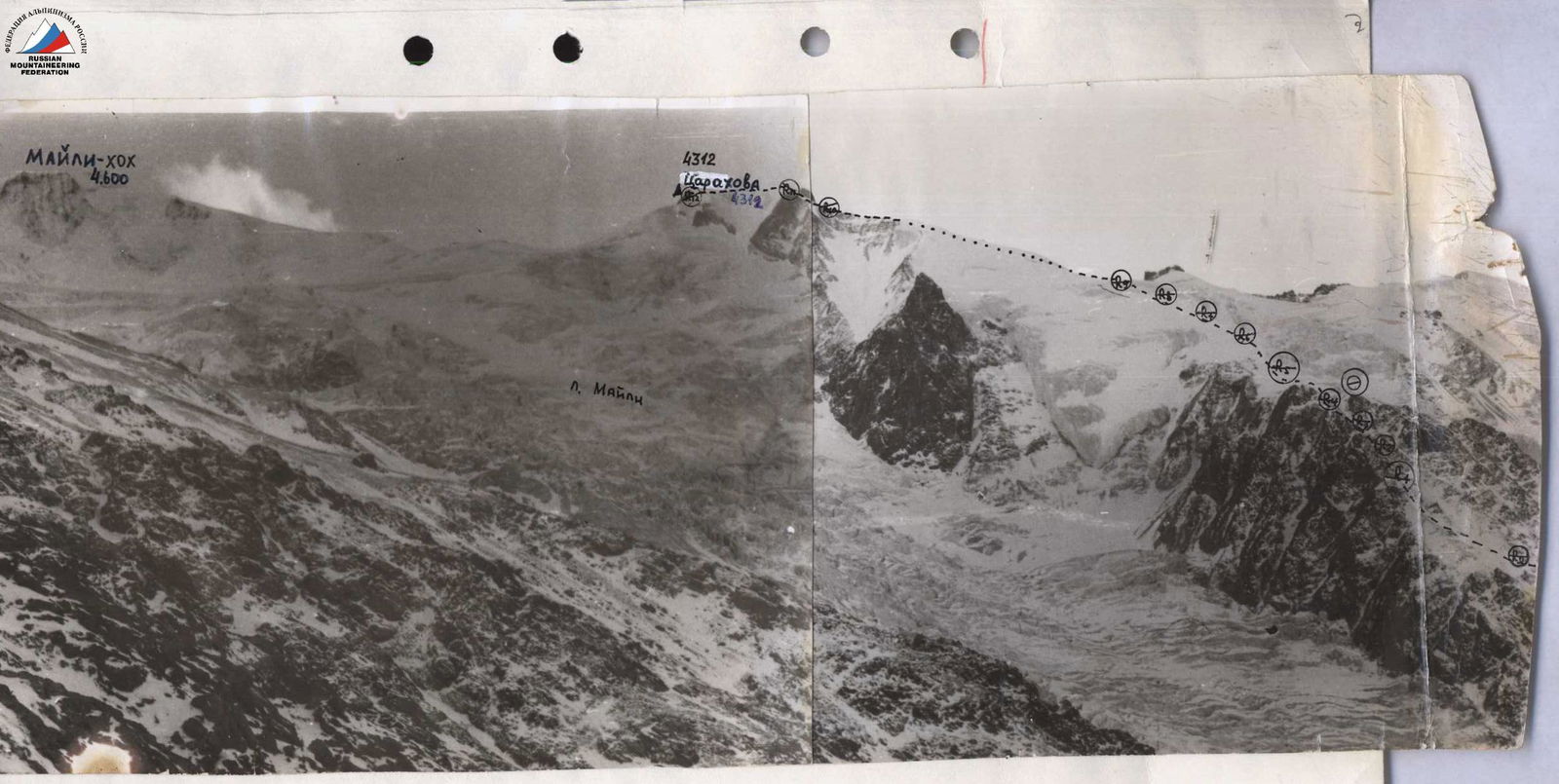
The path along the moraine leads to the контрфорс пика Орджоникидзевской железной дороги (Ordzhonikidze Railway Peak counterfort). During the journey along the moraine, a view of пик Орджоникидзевской железной дороги (Ordzhonikidze Railway Peak) opens up (see photo №1). The time taken to approach from the camp to the counterfort is 3 hours.
The counterfort begins with two standalone rocks. They exit to the right of them. To the rocks and further along the right slope of the counterfort, the path passes over very fine, steep scree (steepness 40–45°), and then over snow. 50 meters (in absolute height) before the main ridge, there is an exit onto the rocks of the counterfort. Under the snow, there is ice at the rocks.
The counterfort leads to the северо-северо-восточный гребень (north-northeast ridge) of пик Орджоникидзевской железной дороги (Ordzhonikidze Railway Peak). Movement is in rope teams with simultaneous belay. The counterfort is traversed in 1.5 hours.
The северо-северо-восточный гребень (north-northeast ridge) is snow-ice, with three "жандармы" (gendarmerie). The snow-ice part of the ridge is narrow, with a steepness of 20–25°. On the left side, towards ледник Чач (Chach glacier), the ridge drops off with rock walls. There are snow cornices. On the right side, there are ice slopes of ледник Майли (Maili glacier) with a steepness of 40–45°.
Movement:
- in rope teams,
- with alternating belay.
The first "жандарм" (gendarme) is taken almost directly head-on, moving along shelves to the right. The rocks are very fragile, with many "live" stones. Belay is via protrusions.
Then, there is a 40-meter snow-ice section of the ridge with a large cornice.
The second "жандарм" is bypassed on the right. The rocks are very fragile, with unreliable footholds. Climbing is of medium difficulty. Belay is challenging.
Beyond the second "жандарм," a control cairn is built. Further to the third "жандарм," the ridge is icy, with a steepness of up to 35° and a length of 50–55 meters. Movement is in rope teams with piton belay; two ice pitons are hammered in. The third "жандарм" is bypassed on the ice. An icy slope with a steepness of 30–35° is traversed. Belay is via pitons. One ice piton and one rock piton are hammered in. After the "жандарм," to the left of the ridge, there is a small quadrangular massif. Further, the ridge is rock-ice, with a length of 3–4 rope lengths. Movement is with alternating belay via protrusions. To the summit, there is an icy slope with a steepness of 30–35° and a length of 40–45 meters. The character of the ice is натёчный (formed by dripping water). The summit is rocky, with destroyed rocks.
On the destroyed rocks of the summit, a cairn is built on a protrusion facing towards вершина Казбек (Kazbek peak).
The ascent to the северо-северо-восточный гребень (north-northeast ridge) from the first "жандарм" takes 1.5 hours.
Descent is via the ascent route. Descent from the third "жандарм" is head-on, via rocks. It is possible to descend via fine scree with a steepness of 35–40° to ледник Чач (Chach glacier). 150–200 meters before reaching the glacier, it is necessary to begin traversing the slopes of пик Орджоникидзевской железной дороги (Ordzhonikidze Railway Peak) to the гребень левобережной морены (left-bank moraine ridge). Descent to the base camp takes 3.5–4 hours.
The route corresponds to category П-Б difficulty. Recommended equipment for a group of 4:
- Ropes — 2 pcs. × 40 m
- Rock pitons — 3 pcs.
- Ice pitons — 3 pcs.
- Crampons — 4 pairs.
- Carabiners — 4 pcs.
The description was compiled by:  G. Eputaev. R. Proskuryakov.
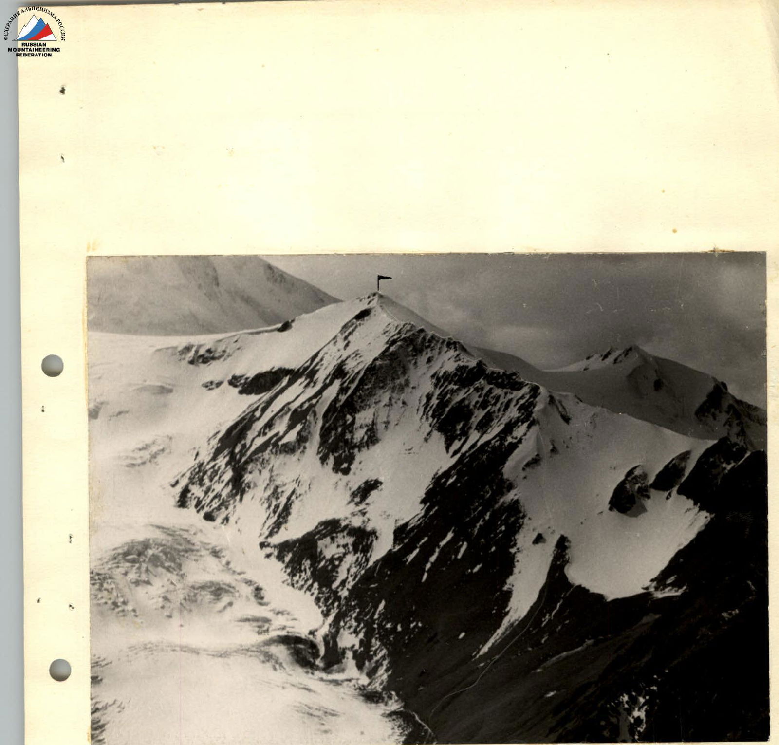
Пик 4005 м (Пик Орджоникидзевской железной дороги) (Peak 4005 m, Ordzhonikidze Railway Peak). Telephoto by R. Proskuryakov.
Map-Scheme