Ascent Passport
- Caucasus, Tepli region, classification section number 2.8.
- Pakota North (3505 m) – from the North.
- Proposed 1B category of difficulty, first ascent.
- Route character — rocky.
- Route height difference — 350 m (from point R0).
Total route length — about 500 m. Length of sections with 4 category of difficulty — 10 m. Average steepness:
- key sections — 70°
- entire route — 30°
- Hooks left on the route — none.
Number of placed protection on the route — 3.
- Climbing hours — 5; days — 1.
- Team leader: Egorin Sergey Vladimirovich — Master of Sports
Team members:
- Abramov Andrey Yuryevich — badge holder
- Stadeev Nikolay Grigoryevich — 1st sports category.
- Coach: Egorin S.V.
- Approach to the route: October 21, 2004.
Reached the summit: October 21, 2004. Returned to Base Camp: October 21, 2004.
- Organization: North Ossetian Search and Rescue Team of EMERCOM of Russia.
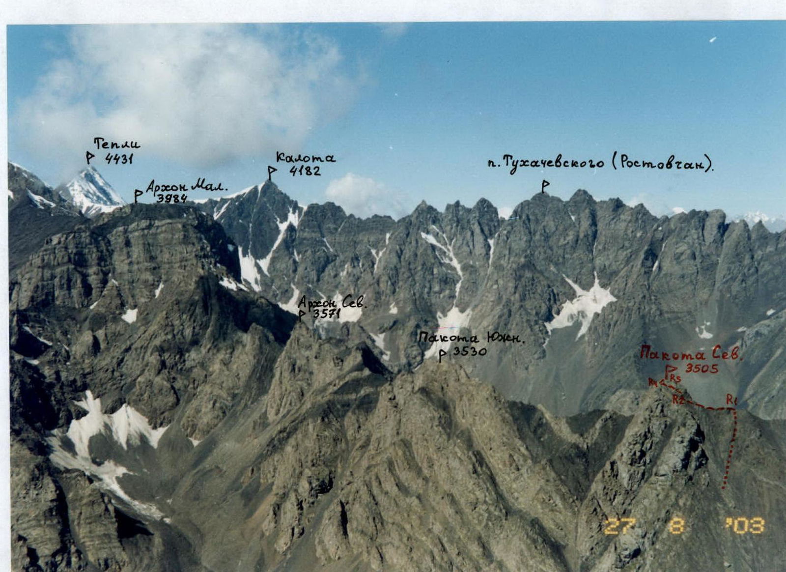
View from the East from a helicopter at the Arkhon-Pakota massif and Kalotinskaya "saw". August. The first ascent route on Pakota North is marked
Brief Overview of the Ascent Area
The ascent area is located in the Republic of North Ossetia — Alania, in the Tepli-Kalota mountain massif. This massif belongs to the Lateral Ridge. From two peaks of this region — Kalota and Arkhon Main — long ridges extend northward, which bound the Tsadjiudon river gorge from the west and east.
Geologically, this gorge is very interesting, as it is a zone of contact between magmatic and sedimentary rocks. Some ribs and counterforts on the slopes of the peaks in this gorge are composed of strong crystalline rocks, while the couloirs between them are formed by clay shales. The Tsadjiu glacier itself is a glaciological monument — the only glacier in Ossetia of the Turkestan type, meaning:
- It lacks a feeding area (firn field)
- It exists due to avalanches and icefalls from the surrounding slopes
In terms of sports, the Tsadjiu gorge is very promising. There are many unclimbed peaks and unattempted routes from the first to the fifth category of difficulty, with rocky, combined, and icy terrain.
In particular, the North ridge of the Kalota peak, known as the "Kalotinskaya pila", bounds the gorge from the West. This ridge is heavily serrated, with twelve peaks, seven of which remain unconquered.
Technically interesting are:
- The eastern slopes of the Kalotinskaya pila,
- unclimbed ribs and counterforts,
- traverses of individual peaks.
To the East, the Arkhonov ridge bounds the gorge. This includes (from South to North):
- Arkhon South-West
- Center
- Rocky Main
- Small
- North
Further north along the ridge are the Pakota peaks. The western slopes of the Arkhonov are technically complex and have good glaciation. The height difference from the glacier to the peaks reaches 1 km. Previously, the gorge was rarely visited due to its remoteness from alpine camps and its belonging to the North Ossetian State Reserve. Only in recent years has the Tsadjiu gorge begun to be actively explored by climbers from North Ossetia.
To visit the gorge, a border zone permit is not required. There is mobile phone coverage in some areas of the gorge — through the Fiagdon repeater (more stable in the lower part).
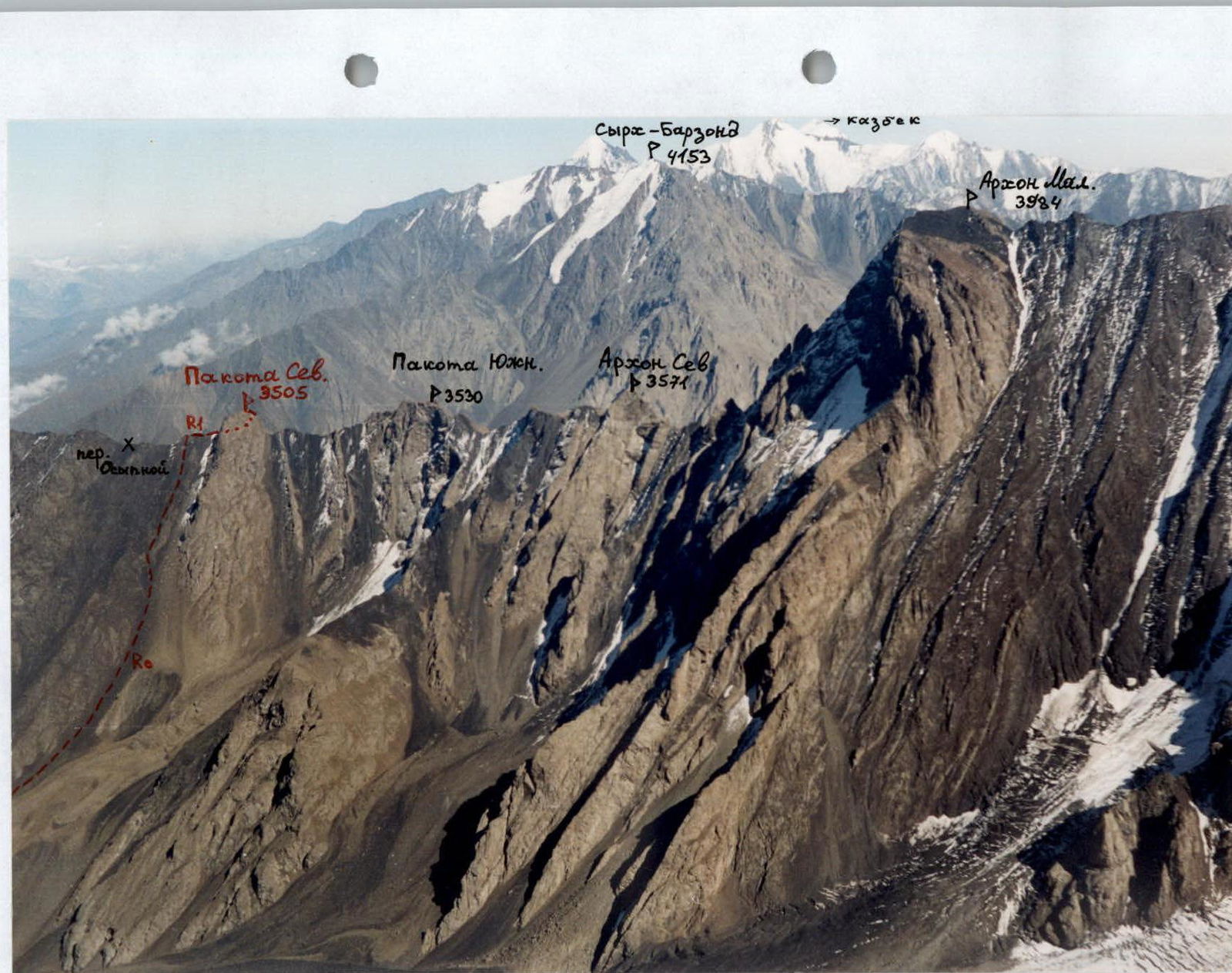
Photopanorama of the area and view from the West at the Arkhon-Pakota massif. September. Photo from p. Tukhachevsky (Rostovchane). The first ascent route on Pakota North is marked
Brief Description of the Approach to the Route
Travel from Vladikavkaz city to Kharisdzhin village by bus, 1.5 hours. From the village, follow the dirt road up the Fiagdon river gorge — 2 km, to the mouth of the Tsadjiudon river. Follow the trail on the left side of the river past the tower to the old road. Follow it on the left (in the direction of travel) of the river until the road ends at a scree slope leading into the river. Here, cross the Tsadjiu river via logs. After crossing to the right bank of the river (in the direction of travel), ascend up the gorge — along the trail that begins near the crossing. After 1.5 hours of walking from Kharisdzhin village, the gorge gradually turns left (South). Here, ascend the slope to the old geological road, visible above. Follow it:
- first through the forest,
- then over a ledge of an ancient overgrown moraine (2200 m),
- exit the forest into the wide, horizontal riverbed. This takes another 1.5 hours.
Further up the gorge, follow the right bank of the river (in the direction of travel) along the trail past a small lake and along the riverbed to a steep morainic ascent. Here, turn up along the left tributary until the river disappears under the scree. Camp here, elevation 2450 m. From Kharisdzhin village, 5–6 hours. Camping higher is not advisable due to lack of water.
Path to the North ridge of Pakota North. View from the West
Description of the Ascent Route
From the campsite, ascend up the dry riverbed. To the right (in the direction of travel) is a morainic hill, and to the left are grassy-scree western slopes leading to the North ridge of Pakota North.
30–40 minutes from the campsite, turn left and begin ascending the scree slope into the cirque, which leads under the western walls of Pakota peak.
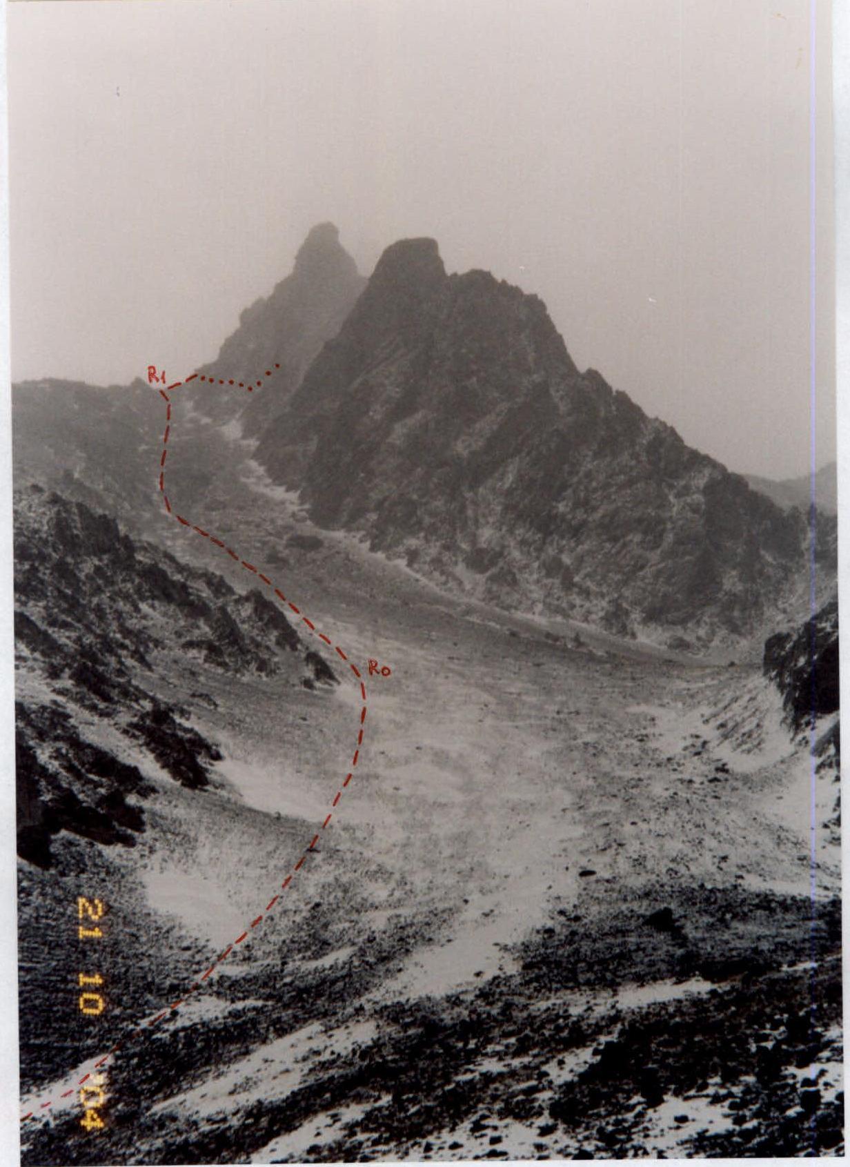
After 30 minutes of ascent, an scree slope with rock outcrops becomes visible, leading to the Oсыпаной pass.
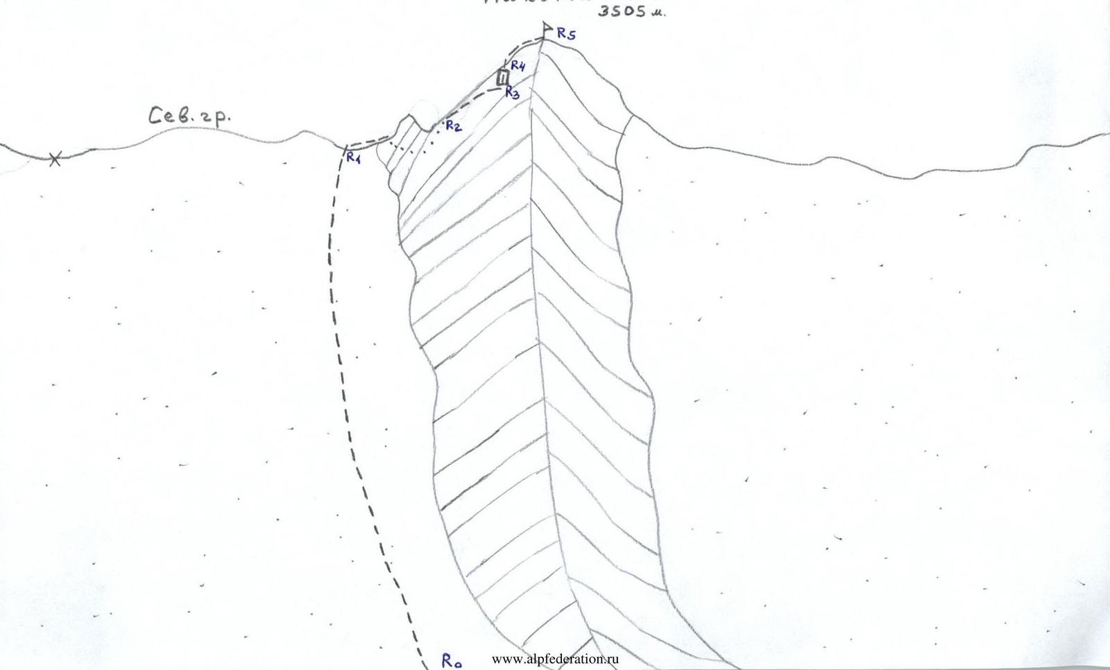
Section R0–R1:
Ascend the rocky-scree slope, going up to the left of the Western counterfort, which leads to Pakota North peak. Reach the ridge to the right of the saddle, i.e., closer to the summit tower. Section about 300 m; 1–2 category of difficulty; 20–30°.
Section R1–R2:
The further ascent path goes first along the North ridge, then under the base of the Black gendarme, which should be bypassed on the left.
- First, descend to the couloir
- Cross it diagonally upwards to the left — belay! With a large amount of snow, it is avalanche-prone!
- Continue ascending diagonally upwards to the left through ledges with small rocky outcrops of 2–3 category of difficulty between them, until reaching a poorly defined ridge — a slope inflection.
- Here, turn right.
The entire section is about 80 m; 1–2 category of difficulty; 20–40°.
Section R2–R3:
Turn right and follow the system of ledges (with dropoffs on the left) under the dark rocks above, against the sky. Section 1–2 category of difficulty; about 50 m; 20–30°.
Section R3–R4:
Follow the system of ledges to the key wall 10 m; 4 category of difficulty; 50–70°. Ascend it, first on the left part, then straight up, to reach the top of the summit tower.
Section R4–R5:
Here, turn right and follow the ridge of 2–3 category of difficulty; 60 m, to reach Pakota North peak (3505 m).

View from the North ridge at the left part of the summit tower of Pakota North. The first ascent route is marked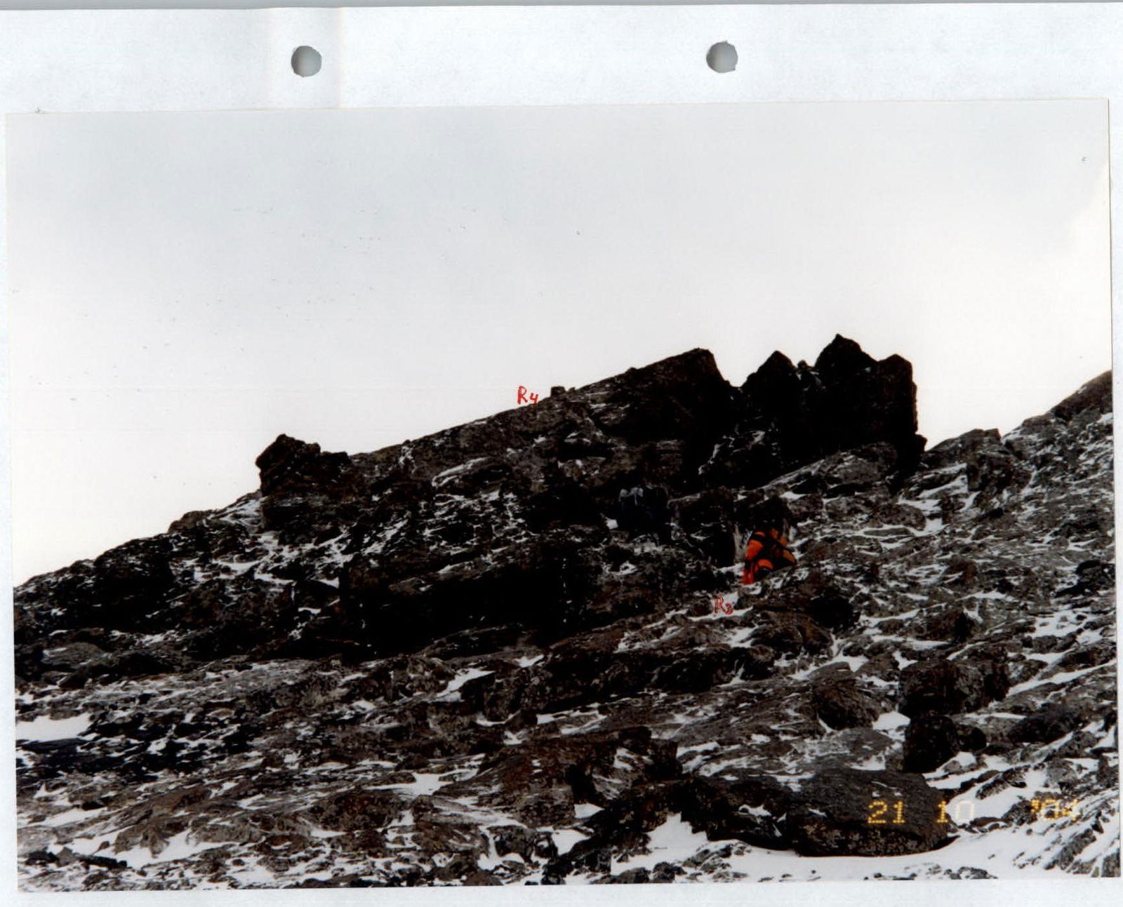
Passage of the key section of the route. Ascent to the summit tower. Lower part of section R3–R4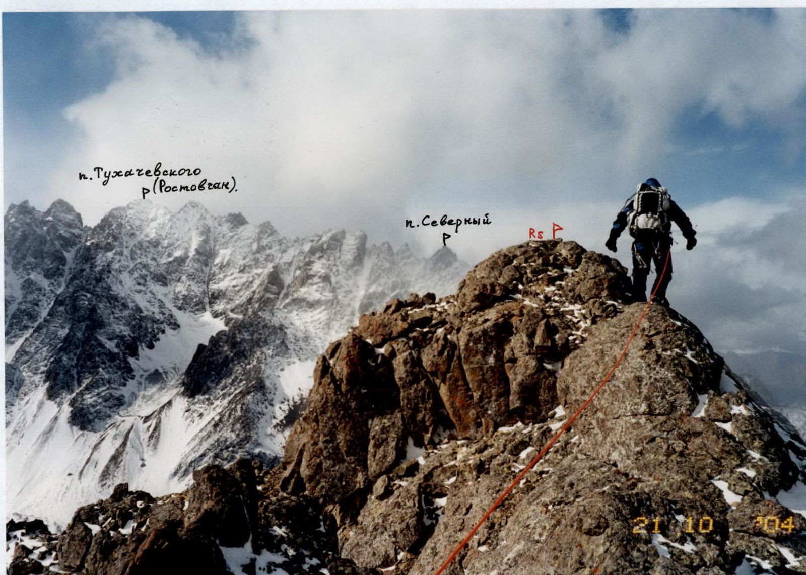
Ascent to the summit. Section R4–R5. In the background, the Kalotinskaya "saw"
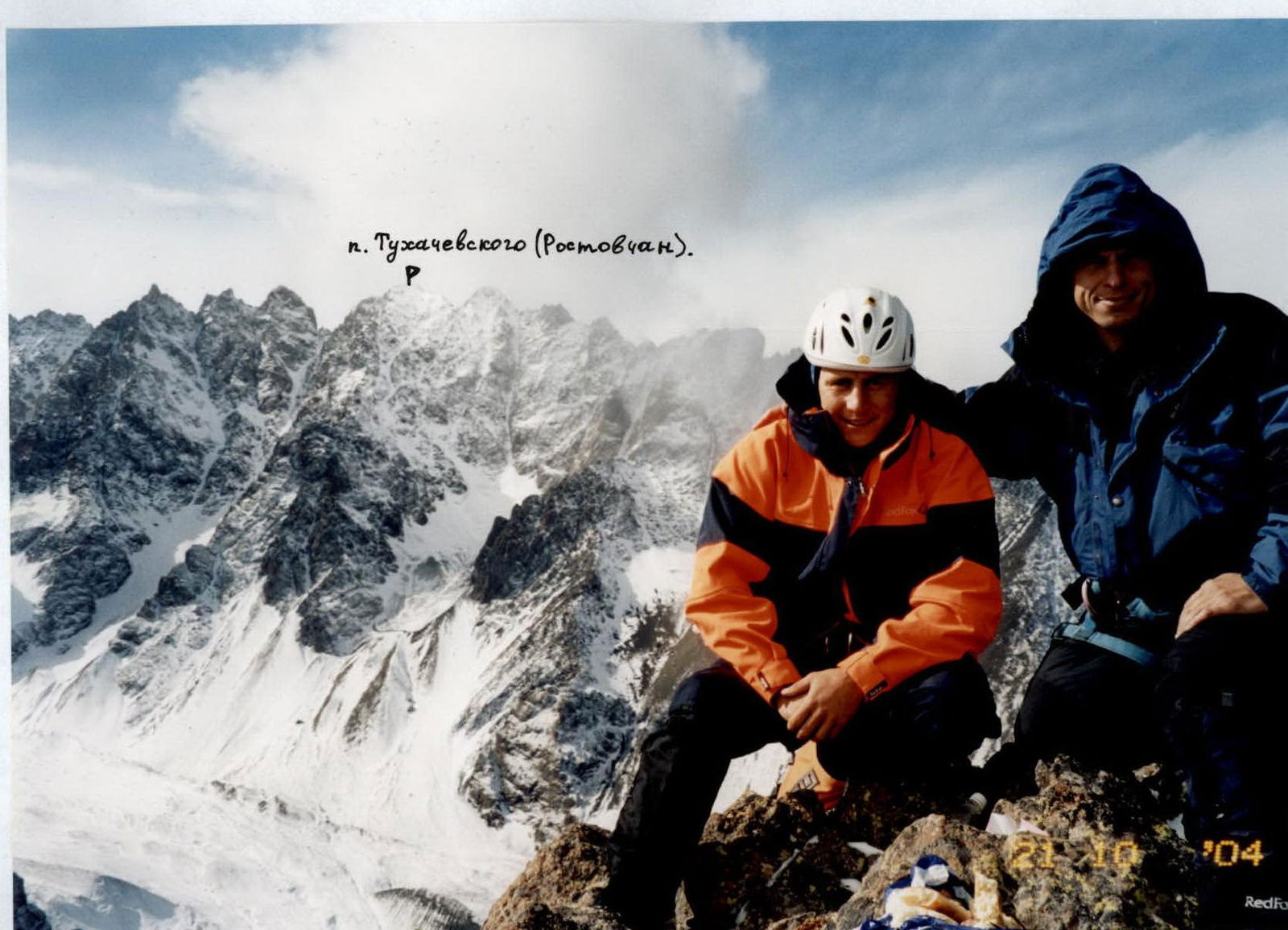
At the summit of Pakota North (3505 m) – October 21, 2004. In the background, the Kalotinskaya "saw"