Ascent Passport
- Caucasus, Rock Ridge, Classification section number — 2.8.
- Kuardjin East (2600 m); via the South wall of the East ridge.
- Proposed 3A category; first ascent.
- Route character — rock climbing.
- Route height difference – 320 m.
Length of the wall part – 415 m. Total route length – 715 m. Length of sections with 5th category difficulty – 5 m. Steepness of key sections 80–90°.
- Pitons left on the route – 5.
- Team's working hours – 8 hours; days – 2.
- Leader: Egorin S.V. – Master of Sports
Team members:
- Abramov A.Yu. – 3rd sports category
- Zhirnov D.N. – 2nd sports category
- Rodin A.V. – 2nd sports category
- Salikov S.V. – 2nd sports category
- Coach: Egorin S.V.
- Approach to the route (preparation) – 17:00; March 29, 2005.
Ascent to the summit: 14:00; March 30, 2005. Return to Base Camp – 18:00; March 30, 2005.
- Organization: North Ossetian Rescue Team, Ministry of Emergency Situations of Russia.
General view of Kuardjin peaks from the South. The first ascent route is marked.
Brief Overview of the Climbing Area
The Kuardjin-Araukhokh massif, part of the Rock Ridge, is located in the Republic of North Ossetia-Alania, between the Genaldon River to the West and the Terek River to the East. The massif is visible from Vladikavkaz city and is situated to its Southwest, 15 km away. The massif stretches from West to East for 4 km and has a spur to the South with the technically easy peak Khiakh (2771 m).
This section of the Rock Ridge has been frequently visited by North Ossetian climbers in winter and during the off-season due to its proximity to the city, primarily for one-day training climbs of 1A category. Previously, the entire massif was referred to only as Araukhokh. Specific names were given to the most frequently visited points of the massif:
- peak 2392 m (with a triangulation mark) – Arau East;
- mark 2548 m (located 1.5 km to the West, visible on a 1:50,000 scale map) – Arau Center.
The remaining Western part of the massif was referred to as Arau West, without specifying the location of the peak. This part of Arau was virtually unvisited due to its technical difficulty for one-day climbs.
Only in 1987 did a group led by Yu. Levkovsky traverse from Arau East to the Узловая башня (Uzlовая башня) in the Western part of the massif. They repeated this 2B category traverse in the mid-90s for photography purposes on the route; around the same time, 1:50,000 scale maps became available, revealing that the Western part of the massif is named Kuardjin.
This part of the massif is the most interesting in terms of sports:
- The ridge is a series of rock towers – peaks with a height difference of up to 100 m.
- To the South, the ridge drops off with walls up to 300 m.
- The rock is of sedimentary origin – limestones, etc.
In 2000, a group led by S. Egorin traversed all the towers of Kuardjin from West to East and on to Arau Center. This was rated as 3A category.
View from the South on the Kuardjin and Arau Center massif. Photo from peak Khiakh. The first ascent route is marked in red. The 3A category traverse is marked in black.
Approach to the Route Description
To reach the South walls of Kuardjin peak:
- From the East – through the "Skvaeli" gorge, where the Darial military training ground is located. However, recently, shooting practices have made it impossible to pass through.
- Previously, before the Kolka glacier collapse, it was possible to pass from the West – through the Genal tract, but there is currently no road from the bottom along the Genaldon River valley.
- Therefore, the most optimal path now is from the South – via the Saniban pass and peak Khiakh.
From Vladikavkaz city, drive through the village of Chmi to the Saniban pass (1910 m) – a dirt road; 1 hour drive from the city; bring passports – there is a border checkpoint on the road before the pass.
At the pass, head North through grassy fields under the Southern slopes of the visible peak Khiakh. Then ascend the steep grassy and scree slope, bypassing rock outcrops to the right. In the upper part, enter a wide scree (in winter with snow) couloir and exit left upwards onto the East ridge of Khiakh.
From the pass: 3 hours; height 2600 m. To the North, the Kuardjin-Arau massif is visible.
Then turn left and along the East ridge, bypassing difficult rock sections to the right (with a lot of snow, the North slopes are avalanche-prone!), in half an hour reach peak Khiakh (2771 m).
From the summit, along the North ridge, mostly on its left part, descend towards the visible rock towers of the Kuardjin massif. 20 minutes before reaching the Олений (Oleniy) pass (2450 m) (a saddle in the North ridge of Khiakh near the South walls of Kuardjin Узл.) – there is a possible overnight stay in a grotto on the left below, but it's dirty. Another overnight option is on the Олений pass.
Also, when approaching the South walls of the massif, one can:
- move along them to the right and down to a ledge under overhanging rocks (it's 100 m to the right of the start of the route on the South wall).
The height loss from peak Khiakh is about 400 m. From Saniban pass to the grotto is about 6 hours. To the start of the route is 6.5 hours. Water is available in the form of snow on the slope bends with Northern exposure from November to May.
Technical part of the route. Semi-profile of the wall, view from the Southwest, from Олений pass.
Route Description
From Олений pass, looking towards the South walls of the Kuardjin massif to the right and down, a long horizontal ledge under the overhanging rocks at the base of the South walls is visible. On this ledge, a comfortable overnight stay is possible, 10 minutes away. In the left part of the ledge, the rock above it has the appearance of a reddish triangle up to 20 m high. 70 m to the left of this triangle, there is a small rib at the base of the wall, and in its left part, an inclined grassy ledge – this is the start of the route on the South wall of the East ridge to Kuardjin East.
Section R0–R1: From the grassy ledge, ascend to the right and upwards onto the rib. Initially upwards on it, "loose rocks!", then onto a ledge with juniper to the left and upwards along a small wall to the next ledge. The entire section is 50 m. Steepness 60–80°. Rock difficulty 3–4+.
Section R1–R2: From the ledge, traverse left under grey overhanging rocks for about 7 m. Then up the wall to the left until its bend. Here, to the right along ledges, in a groove with many stones, approach the base of the left chimney – a crack. The entire section is 50 m. Steepness 70–80°. Wall difficulty 4–4+.
Section R2–R3: Up the corner – chimney 5 m to a ledge. Then to the right and upwards through a system of internal corners and small walls between them, exit onto the shoulder of the wall. Section 40 m, steepness 50–60°, 3–4.
Section R3–R4: Along the shoulder, approach the wall. Here, to the right below in a niche is a control cairn. To its left, ascend the wall, after 3 m, a piton. Another 3 m up, then descend slightly to the right along a ledge to a yellow wall. Through it (with a piton) and over the wall's bend, move to the right and upwards. This transition is 5; 2 m; 90°.
Then traverse to the right into a rocky groove – couloir. Up the couloir to a ledge under overhanging rocks. In the upper left part of the ledge, a piton (carrot-shaped).
The entire section is 25 m; the first and last 6 m are 4+. Steepness 60–90°.
Section R4–R5:
- From the ledge, move to the right and up a chimney 10–12 m, 4–4+, with steepness up to 90° – to the right onto a shoulder.
- Here, a piton is placed.
- It's convenient to belay from here.
Section R5–R6: From the shoulder, traverse 4 m to the right to a grey slab. Up the slab 3 m, piton, (to its right and left are loose rocks). The slab is 90°; 5. Then up the rocks 4–4+ to the wall's bend and exit onto a large grassy ledge with a steepness of 20°. Ropes can be anchored here on a protrusion and re-routed after straightening to the right and down – to the R4 ledge. It turns out to be exactly 50 m.
Section R6–R7: Along the ledge, on grass, approach the upper rock belt. Along it, move to the right to a shoulder. Here is a cairn for orientation. Then descend to the right and down, and after another 50 m, turn left and enter a couloir. The entire section is about 100 m; 20–30°; 1–2.
Section R7–R8:
- Pass a rock step (3 m; 3) in the lower part of the scree couloir,
- Then ascend the couloir,
- To the exit onto the East ridge of Kuardjin East.
Section 100 m; 20–30°; 1–3.
Section R8–R9: On the ridge, turn left and, bypassing difficult sections to the right, approach a gendarme. Bypass the gendarme's rocks from the North on ledges and descend to a col.
- Section 150 m
- 20–40°
- 1–3
Section R9–R10: Further along the ridge with rock outcrops, bypassing difficult sections on ledges, ascend to Kuardjin East (2600 m).
- Section 150 m
- 20–30°
- 1–2
Descent from the summit along the East ridge to the saddle between Kuardjin East and Arau Center. Before the saddle, a rappel 3 m; and further down on ledges, bypassing rock walls. Descent from the saddle to the right and down to the South, along the Easternmost couloir. Then to the West under the base of the South walls, through the horizontal ledge under overhanging rocks, to Олений pass. Return via:
- Khiakh
- "Skvaeli"
R8–R10: 300 m, 20–40°, 1–3 category.
R8
Passage of section R0–R1. First rope of the wall.
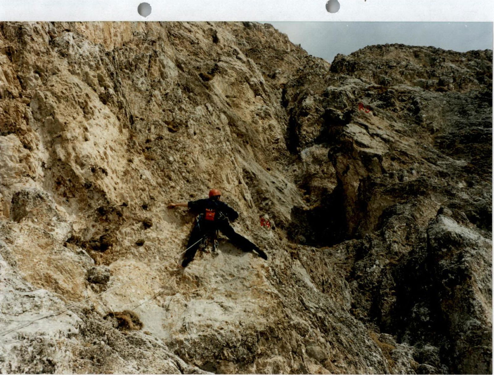
Passage of the key part of section R3–R4

Section R4–R5
Conclusions and Recommendations for the Route
The route is recommended for:
- training ascents by sports teams,
- training ascents by strong groups,
- climbing with an experienced instructor.
The wall section of the route (first five ropes) is the key to the entire ascent. Working on the wall develops skills necessary for more serious and prolonged wall climbs.
When climbing the route, one must follow the description precisely, otherwise, very difficult sections may be encountered. For work on the route, the following are necessary:
- pitons of various profiles and sizes;
- protection gear.
For belays, 2 jumars are needed. Water, in the form of snow, is available under the route (at overnight stops) and on the route only from November to May. It's necessary to have one hanging loop for a piton; and 50 m ropes.
We propose classifying the route as 3A, although the complexity of the key sections of this route is sufficient for 3B, but due to its relatively short length, it's better classified as 3A. For example, the route climbed is more complex than the route to Тбау (Tbau) Northwest from the South via the "well" and Northwest ridge, which is 3A category.