Ascent Log
- Climbing category: rock climbing
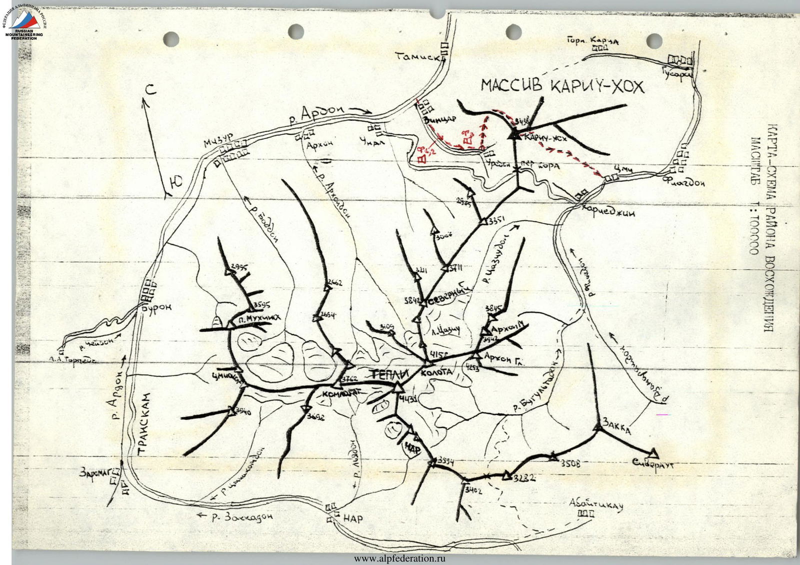
- Climbing area: Caucasus, (2.8), Ardon River gorge
- Peak, route: Kariu-Khokh (3438 m) from the south via the NW ridge
- Estimated category of difficulty: 3A, first ascent
- Height difference: 1200 m. Total route length: 2300 m. Average slope of the route: 33°.
- Pitons hammered: rock — 6 pcs., chocks — 8 pcs.
- Number of travel hours/days: 10/1
- Overnights: 1st — on the approach 2nd — on the descent.
- Leader: Ivanov Vitaly Valentinovich, Candidate Master of Sports Participants: Egorin Sergey Vladimirovich, Candidate Master of Sports Bondarenko Igor Olegovich, Candidate Master of Sports
- Coach: Khamitsaev Kazbek Borisovich, Candidate Master of Sports
- Departure to the route — January 8, 1994 Summit — January 6, 1994 Return — January 9, 1994
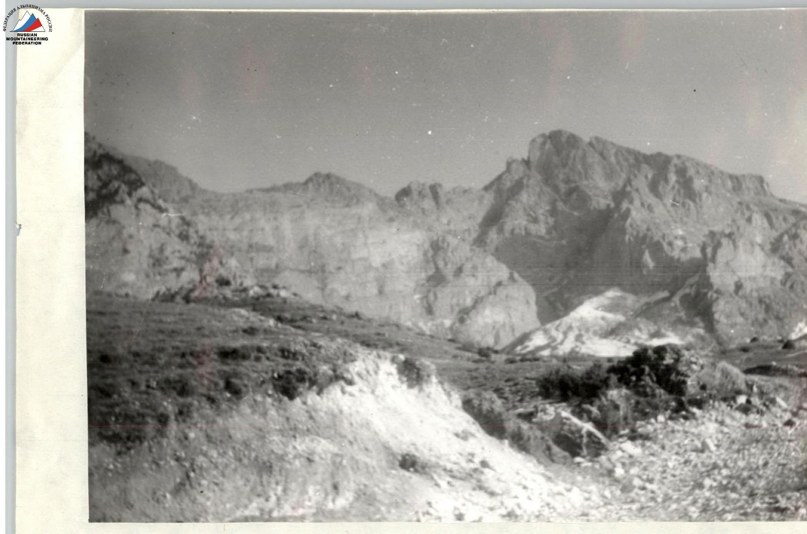
PHOTO #2. View of Kariu-Khokh peak from the southwest. The NW ridge is visible on the left against the sky.
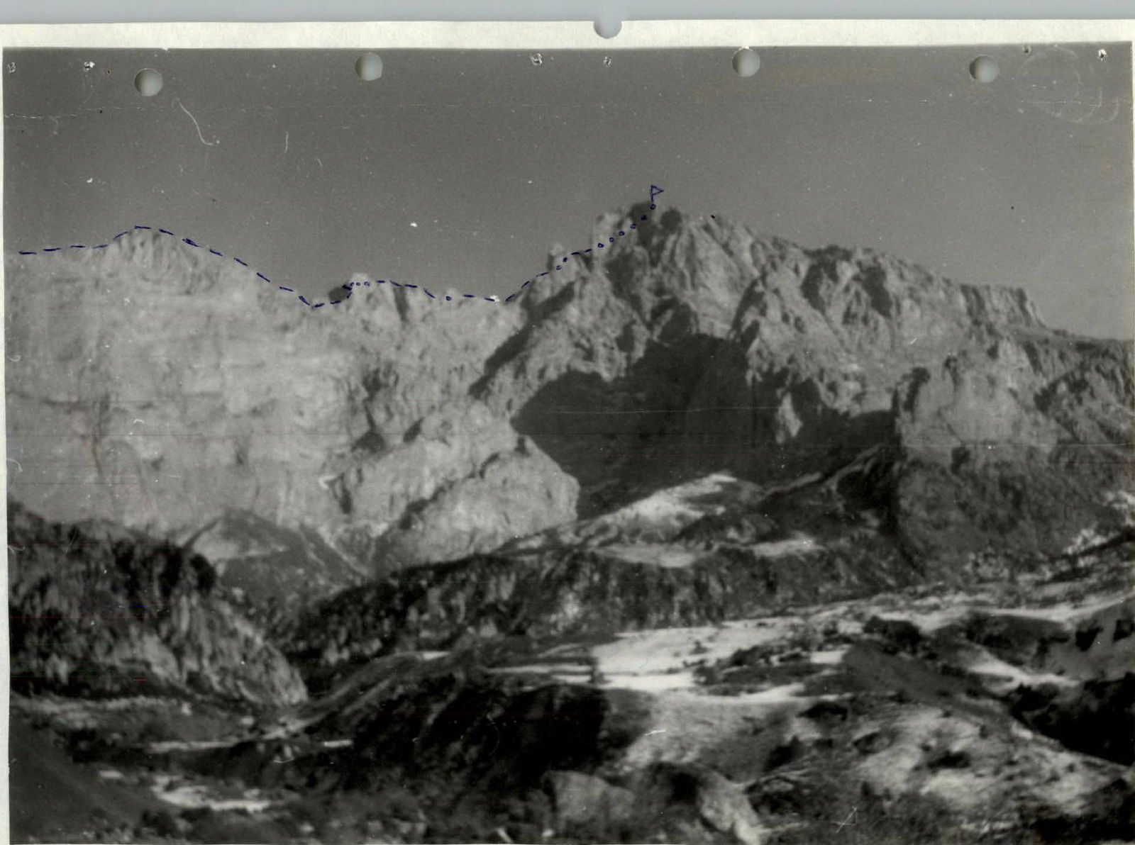
PHOTO #3. View of Kariu-Khokh peak from the southwest. The NW ridge is visible on the left against the sky.
Brief Overview of the Climbing Area and Approach Description
The climbing area is located in the North-Eastern Caucasus in the Ardon River basin. Kariu-Khokh mountain is part of a rocky ridge and is a large standalone peak with a height of 3438 m. To the north, east, and south from the peak, there are grassy talus slopes and ridges with small rock outcrops, while to the west, the massif drops off with an 800-meter wall of broken limestone, which, according to scientists, was formed as a result of a massive landslide.
A peculiarity of the area is its location in the so-called Sunny valley. The southwestern foot of the peak lies in the Unal depression. Here, the rocky ridge acts as a barrier to northern humid and cold atmospheric currents. Before the rocky ridge, precipitation is always twice as much as behind it, in the "rain shadow" zone. Annual precipitation to the north of the mountain is: 911 mm in Tamisk and 403 mm in Unal. The Unal depression is the driest place in all of North Ossetia, even compared to its plain part. Therefore, the southwestern and southern slopes of Kariu-Khokh have all the features of a mountain semi-desert. Hence, one of the challenges during the ascent is the lack of water (snow) on the route, approximately from the end of May to mid-November. In winter, the snow cover is characterized by low power and instability. There are sometimes snowless winters.
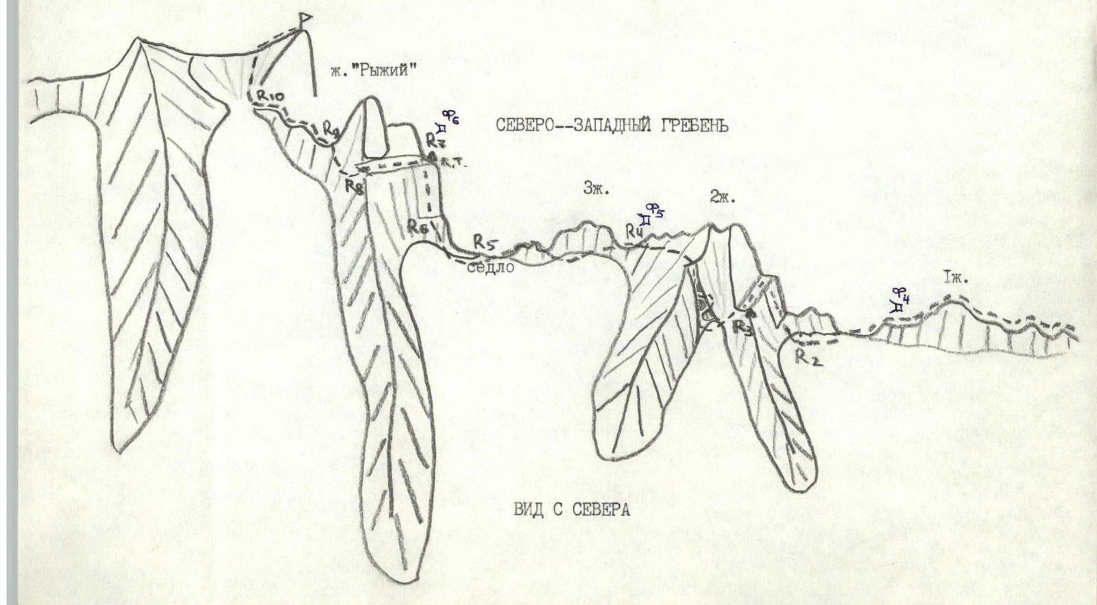
The Northwest ridge is a pronounced long rocky ridge with gendarmes. It is composed of limestone; the relief of the rocks allows the use of any pitons and chocks of all modifications and sizes. The ridge drops off with steep walls to the south and more gentle rocky-talus slopes to the north. The route follows the ridge line throughout (from the moment it exits from the south onto the ridge), bypassing some gendarmes on the left (on the northern side), and leads directly to the summit. The route is clearly defined and very logical.
VISITATION: there have been no ascents to the peak from the northwest, west, and southwest. The main ascent paths were routes from the neighboring Fiagdon River gorge to the east, along the eastern and southeastern slopes (approximately 1A category of difficulty).
ACCESS PATH: convenient, as the Transcaucasian Highway passes through the Ardon River gorge. The route by car: Vladikavkaz – Alagir – Zincar (7% 50 km). Public transport can be used to reach Zincar. From there, a dirt road goes east across the Ardon River via a bridge.
Approach to the Route Description
Follow the dirt road through the village of Zincar, moving east (toward the Kariu-Khokh massif). After 5 km, the road ends in the last village, Ursdon. On the left (in the direction of travel) above the village, an ancient local "Tsamat" fortress is visible in the rocks. A trail from the village approaches the fortress and rises to the right of it to a flat pasture plateau. From the Transcaucasian Highway, it takes 3–4 hours. There is a possible bivouac on the plateau (no water).
Preparation for the Ascent
During preparation for the ascent, the following were conducted:
- reconnaissance of approaches to the peak;
- determination of the route orientation;
- preliminary assessment;
- as well as principles for ensuring radio communication.
Due to the peak's location in the Sunny valley and minimal precipitation in the area (especially in winter), the ascent was scheduled for winter (when there is snow cover) to avoid carrying water on the route.
During preparation, it was determined that the best communication would be established with Tsey (alplager "Torpedo") on VHF waves. Therefore, a "CACTUS-M" radio station was used on the route for radio communication, ensuring stable radio communication throughout the route.
R0–R1 — exit to the NW ridge 1B category of difficulty ( местами 2B category of difficulty), 3–4 hours R1–R2 — "sawtooth" ridge 700 m, 1–2B category of difficulty (on the 1st gendarme 10 m, 3B category of difficulty) R2–R3 — wall 25 m, 4B category of difficulty, 75° (pitons), ledge to the left 20 m (control cairn) R3–R4 — ledge 40 m, couloir 40 m, 2–3B category of difficulty (alternating), rockfall hazard R4–R5 — bypassing the 3rd gendarme on the left 60 m, 2–3B category of difficulty (alternating) R5–R6 — rocky-talus ascent 40 m R6–R7 — wall 40 m, 4B category of difficulty, 70° (pitons, handrails), control cairn R7–R8 — ledge left-upward 150 m, 2B category of difficulty (alternating) R8–R9 — bypassing the "Red" gendarme 50 m, 2–3B category of difficulty, 60° (alternating) R9–R10 — rocky ridge 50 m, 3B category of difficulty, 60° (pitons) R10 — rocky ascent 70 m, 3B category of difficulty, 60° (belay challenging)

Kariu-Khokh (3438 m)
Route Description by Sections
From the pasture plateau, Kariu-Khokh peak with its Northwest ridge is clearly visible. The plateau is separated from the Northwest ridge by a wall with grassy ledges with a height difference of 500 m.
On the wall, find a white vein, 200 m to the right of which there is a couloir-gutter. The start of the route is to the right of the couloir-gutter along the wall for 10 m, 2nd category of difficulty, to exit onto a wide grassy ledge going right-upward for 500 m. On the ledge, a hunters' trail is noticeable. Reaching small grottos in the wall, the trail goes into a chimney, up 10 m, 2nd category of difficulty, and left-upward along simple rocks to exit onto a grassy ledge going left-upward to the couloir-gutter for 220 m. Up the couloir-gutter for 300 m to exit onto the NW ridge. From the pasture plateau, it takes 3–4 hours. There is a possible bivouac (no water).
Here, turn right and move along the NW ridge for 700 m, 1–2 category of difficulty (on the 1st gendarme 20 m, 3 category of difficulty, which has multiple small drops of 7–10 m, with the first gendarme being the highest).
Moving along the ridge, approach under the wall of the second gendarme, up 25 m, 3–4 category of difficulty, 75° to a ledge, along which left for 20 m, to exit onto the shoulder of the gendarme. From exiting onto the NW ridge, it takes 1 hour 30 minutes – 2 hours.
After the cairn, left along the ledge along the rocks for 40 m to a couloir. Up the couloir for 40 m, 2–3 category of difficulty, three large stones are wedged, forming plugs. Bypass the first plug on the left, the second on the right, and the third on the left. After the couloir, exit back onto the NW ridge behind the 2nd gendarme. Then move along the ridge, bypassing the 3rd gendarme on the left (in the direction of travel) for 60 m, 2–3 category of difficulty, to exit onto a saddle before ascending to the large "red" gendarme. From the saddle along the ridge for 40 m under the wall. Up the wall for 40 m, 4 category of difficulty, 70° — to exit onto a ledge. Here is the second control cairn. From the first control cairn, it takes 2 hours.
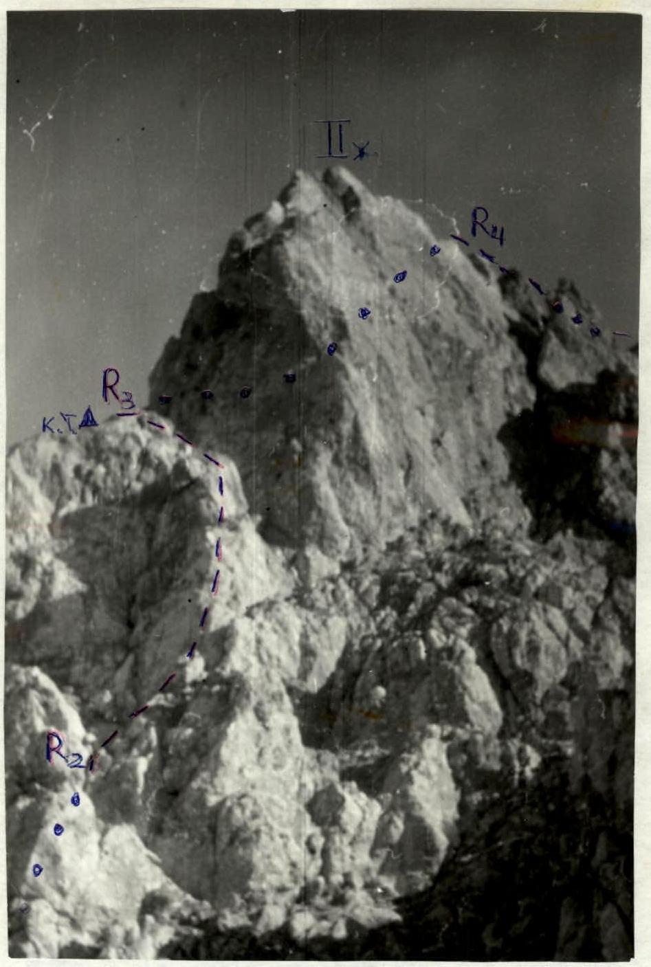
From the cairn, a ledge goes left-upward for 150 m, 2 category of difficulty, under the overhanging "red" gendarme. After the ledge, bypass the gendarme on the left along the rocks for 50 m, 2–3 category of difficulty, 60° to exit onto the NW ridge. From here, along the rocky ridge for another 50 m, 3 category of difficulty, 60° approach under the final rocky ascent of 70 m, 3 category of difficulty, 60° (belay is challenging). The ascent leads directly to the summit.
From the second control cairn, it takes 2 hours. Descent to the southeast to the settlement of Fiagdon presents no difficulties.
The route can be completed from the city in three days.
Recommendations
- There is no water anywhere on the route; the last water is near the village of Ursdon.
In winter:
- If there was bad weather the day before, there may be snow on the southern slopes of the NW ridge.
- From November to May, there is practically always snow on the northern slopes of the ridge.
- The route can be climbed in winter and in the off-season since there is no avalanche hazard on the route. Our ascent was made in early January; there was very little snow.
Section R2–R3: wall 25 m, 4 category of difficulty, 75°, ledge to the left 20 m (control cairn). Photo 4, taken from the ridge after the first gendarme.
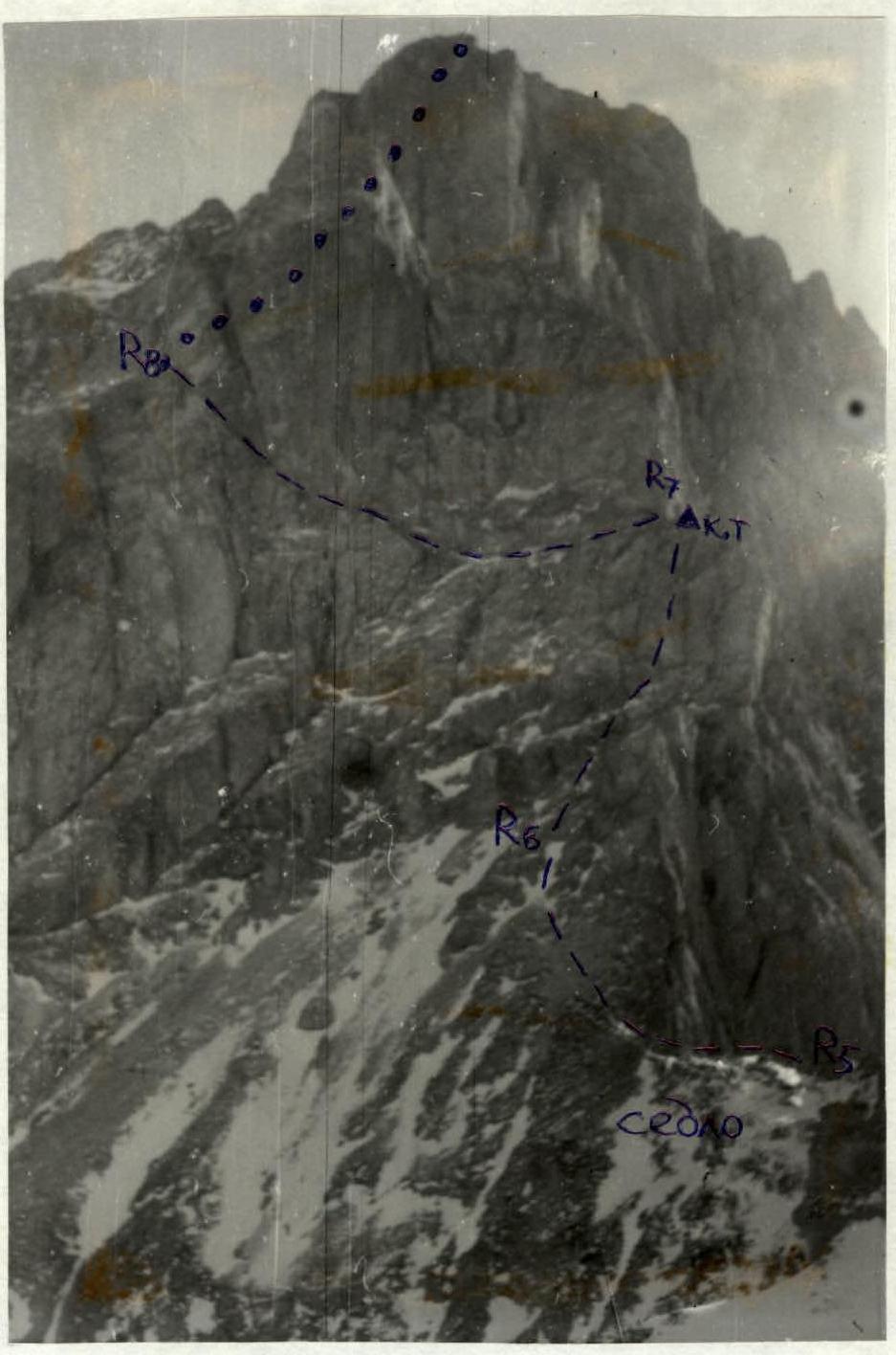
Photo 5. Section R5–R8: from the saddle along the ridge for 40 m, then up the wall for 40 m, 4 category of difficulty, 70° (control cairn). Along the ledge left-upward for 150 m, 2 category of difficulty. Taken from the ridge after the second gendarme.
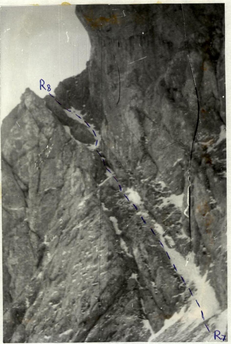
Photo 6. Section R7–R8: from the control cairn, a ledge goes left-upward for 150 m, 2 category of difficulty. Taken from the second control cairn.
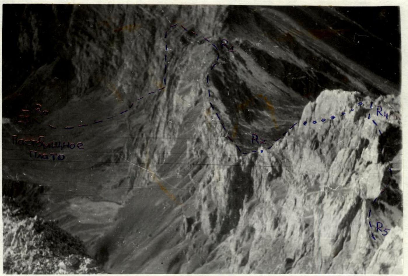
Photo 7. View of the NW ridge from the summit. The start of the route up to section R5 is visible.