
Passport
- Technical class
- Caucasus, Genaldon gorge, Maili glacier
- Kazbek peak via NW ridge-slope from Maili glacier
- Proposed 2B category of difficulty, combined, first ascent
- Elevation gain 2750 m, length (height) of sections: 2B category of difficulty — 1200 m, 3A category of difficulty — 150 m, 2A category of difficulty — 700 m. Average steepness of the rocky part of the route — 35–40°, steepness of the dome (snow-ice) — 40–45°.
- No pitons were left on the route previously.
- Team's travel hours: ascent — 12, descent — 12, including 4 hours searching for the path during descent from the summit in fog.
- Two nights — on the "shoulder" of the plateau
- Leader: Anoshin Georgy Germanovich, Master of Sports Team members:
- Korkin Igor Vasilievich, Master of Sports
- Solovyova Galina Matveevna, Candidate for Master of Sports
- Bula Viktor Sergeevich, Candidate for Master of Sports
- Zavyalets Alexander Nikolaevich, Candidate for Master of Sports
- Milto Tatyana Mikhailovna, Candidate for Master of Sports
- Timaev Tagir Shaikievich, 1st sports category
- Release officer: Anoshin G.G.
- Departure on the route: August 2, 1990 Summit: August 3, 1990 Descent: August 4, 1990
- Organization: ASBT "Torpedo".
The path to the start of the route goes through Gizeldon and Genaldon gorges along the road from Gizel village to the abandoned village of Upper Karmadon. From the village, you can reach the upper Genaldon gorge by a GAZ-66 type vehicle and then along the trail on the left (orogr.) bank of the gorge to the tongue of Maili glacier. The walking distance from Upper Karmadon to the glacier takes 4–5 hours. The exit to the glacier is complicated by the need to cross raging and full-flowing streams flowing from its left part. Up the center of the glacier, and then to the left (orogr.) high moraine and along it (trail) to the hut on Shelestenko clearing. From the glacier tongue — 2–3 hours walk. Initial bivouac is here.
The route to the summit goes along the NW ridge-slope of Kazbek firn plateau, and on the plateau — towards the summit. The start of the route is in the lower part of the characteristic "branching" snow couloir. From here, along the rocks of the counterfort supporting the NW ridge, it is necessary to ascend left-up and up to the axial line of the NW ridge. The rocks are steep, broken with ledges, climbing is of medium difficulty and easy. Movement is simultaneous. Up along the ridge to a large cirque or corrie along crumbly shale rocks. In the right part of the cirque, exit to the ridge and up along it. The rocks are easy, broken. At a convenient location, cross two snow fields-couloirs (20 m and 50 m, steepness 30–35°). Along the talus rocky slope, move up-right under the base of the "shoulder" — a well-defined edge of Kazbek firn plateau. A bivouac is possible here, but it's better to reach the "shoulder", from where Kazbek and the further path to it are visible. Up-right along the talus rocks. The rocks are easy, interspersed with talus ledges. At a convenient location, cross a snow-ice slope (70 m, steepness 30–35°) to the right, up along heavily broken rocks, cross two more snowfields from left to right and ascend to the "shoulder" along the talus. Bivouac here. From the start of the route — 8 hours walk.
Further path along the snow-ice terrain to the summit and back:
- From the bivouac, up and right along the firn of the inclined field towards the summit.
- Cross the transverse snow-ice ridge between rock outcrops on the left (along the route) and a large ice drop on the right.
- Further — towards the saddle between Kazbek and p. Spartak.
- From the saddle, left, traversing Kazbek slopes with a gain in height, approach the ridge of rocks in the left part of the summit dome. Movement is in crampons.
- 50–80 m to the right of the rocks, ascend straight up to the summit (300 m, steepness 40–45°, protection on ice screws). From the bivouac on the "shoulder" — 4 hours walk.
Descent along the ascent route, initially by sports method, and then simultaneously along the firn plateau. From the bivouac to Shelestenko clearing, descent takes 5–6 hours and follows the ascent route.
Route safety assessment:
- Broken rocks require attention when passing steep sections.
- Crossing snow couloirs and fields in the morning requires protection through ice screws.
- It's dangerous to deviate during descent along the main ridge to the right due to the hanging glacier.
Recommendations for climbers:
- For a group of 4 people, have: 1.1. Main rope — 30 m — 2 ends. 1.2. Rock pitons 5–6 pieces. 1.3. Ice screws 6 pieces. 1.4. Crampons 4 pairs. 1.5. Hammer 1 piece. 1.6. Group carabiners 6 pieces.
- Ascend to the summit in good visibility on the plateau, mark the path with wands.
- Have preliminary acclimatization before ascending a "five-thousander".
Table of driven pitons
On the route, when ascending to the summit tower (dome), 6 (six) ice screw pitons were used for protection. Slope steepness 40–45°, terrain — ice with snow, 5–15 cm thick. Section length — 250–300 m.
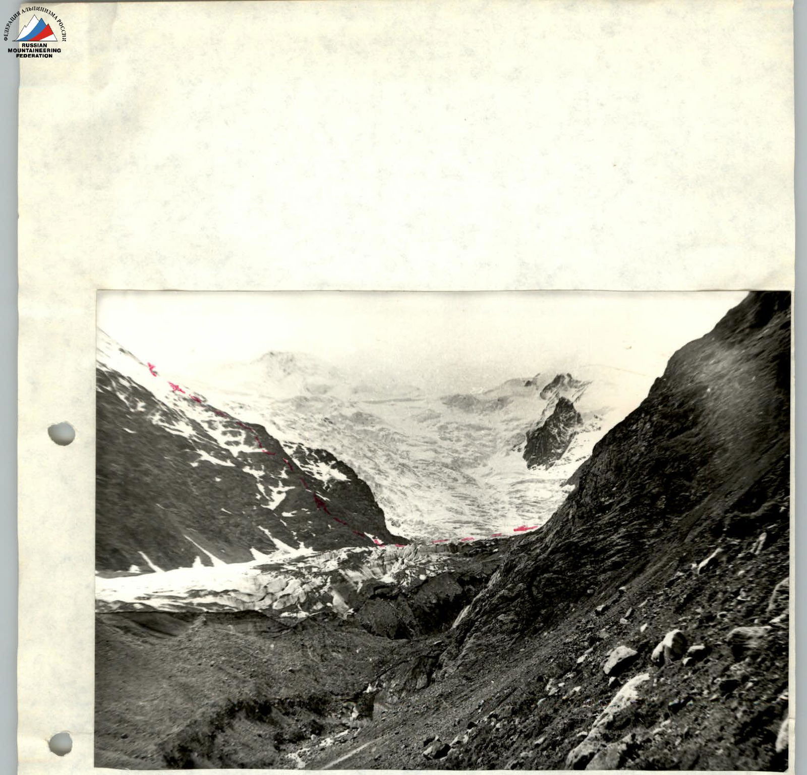
Fig. 3. Northwest ridge. Ascent-descent path.
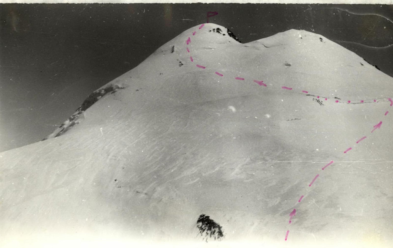
Fig. 4. Kazbek. View from the "shoulder" of the firn plateau.