
Ascent Passport
- Caucasus, Zrug gorge, Classification section number 2.8.
- Zekara (3828 m) — via the North Ridge.
- Proposed category: 1B-2A, first ascent.
- Route type — rock.
- Route elevation gain — about 600 m (from point R0).
Total route length — about 2 km. Length of sections with category 4 difficulty — 10 m. Steepness of key sections — 80°. Average steepness of the route — 35°.
- Pitons left on the route — none.
Pitons used on the route — none. Chocks used on the route — 5.
-
Climbing hours — 5; days — 1.
-
Leader: Egorin S. V. — Master of Sports Team members: Volkov V. N. — Candidate Master of Sports and 8 special unit employees.
-
Coach: Egorin S. V.
-
Route start: August 4, 2007.
-
Organization: North Ossetian Search and Rescue Team, EMERCOM of Russia.
 www.alpfederation.ru ↗
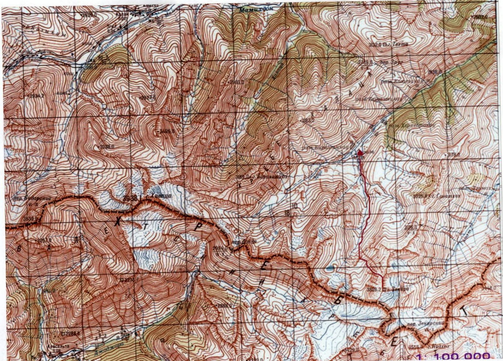 www.alpfederation.ru ↗
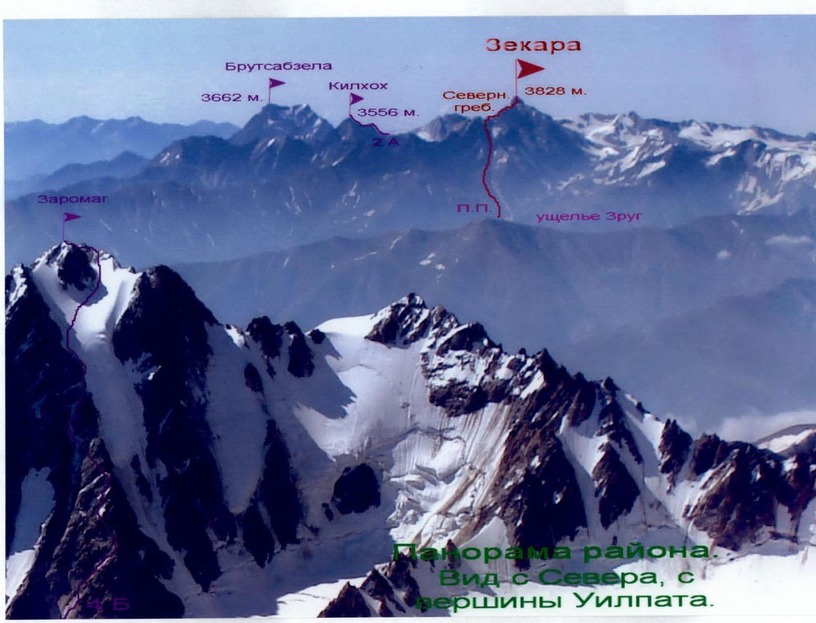
Brief Overview of the Ascent Area. Zekara
The summit of Zekara (3828 m) is located slightly north of the Main Caucasian Range (MCR), on a section of the Watershed Range between the Dzedo pass to the northwest and the Zekar pass to the southeast. In this area, the MCR currently forms the border between the Republic of North Ossetia-Alania and the unrecognized Republic of South Ossetia, i.e., between Russia and Georgia.
Glaciers lie under the slopes of Zekara peak in the cirques:
- Zekara, feeding the Ginat River;
- Western and Southwest Zekara, feeding the Djochiara River;
- a small Northeast Zekara, feeding the Ginat River.
The Main Caucasian Range here is composed of metamorphosed clay shales, with sandstone outcrops in places. On the northern slopes of the range, between numerous ridges and counterforts, some of which are heavily destroyed, are short, receding, cirque glaciers with northern exposure. Below them lie numerous screes and moraines of retreating glaciers.
At elevations below 3000 m, alpine meadows begin with a large variety of grasses and flowers that bloom profusely in the summer.
The climate of the area is typical for the Caucasus — with a maximum of precipitation in the summer months and an average annual rainfall of 1800–2000 mm. Summer at elevations above 3000 m is short and relatively cold (average daily temperature in July-August +16°C). Winter lasts from November to March, with frosts reaching –40°C. Due to the relatively low height of the Watershed Range here, winter precipitation from southern cyclones can be heavy, and after prolonged snowfalls, approaches through the gorge become highly avalanche-prone.
Despite Zekara peak being technically moderately complex with relatively simple routes, few ascents have been made. Apparently, this is due to its remoteness from alpine camps and settlements.
On September 16, 1935, the following ascended Zekara from the northeast:
- A. Metreveli;
- K. Gassiev;
- G. Kakoev;
- A. Sanakoev;
- S. Stokoev;
- A. Tskhurbaev.
And on August 12, 1948, K. Astakhishvili and T. Akhmeteli ascended from the south via a route categorized 1B.
The North Ridge had not been traversed before, likely due to its length and greater complexity compared to other paths to the summit.
In August 2007, joint training camps were held in the Zrugdon gorge between:
- employees of the North Ossetian Search and Rescue Team, EMERCOM of Russia;
- employees of law enforcement agencies.
During these camps, the ascent to Zekara peak via the North Ridge was made.
Description of the Approach to the Route
To reach the Transcaucasian Highway (TCH), take a regular bus to the village of Nar, where the house-museum of the Ossetian poet Kosta Khetagurov is located.
From the village of Nar, cross the Lyadon and Zakk rivers via a viaduct. Turn right off the TCH and follow a dirt road to the Zrug River. Cross it via a bridge, turn left, and ascend along the road on the right side of the Zrug gorge. The upper reaches of the Zrug gorge are a border zone, so it is necessary to obtain border permits in Vladikavkaz in advance.
The road initially follows the bottom of the gorge, then rises up the slope to bypass a canyon. After some time, the gorge widens again, and the dirt road crosses to the left side of the gorge via a bridge. From the village of Nar — 3–4 hours.
To the right of the road are the remains of an ancient Christian temple from the 11th century, Hozita.
Another half hour from the bridge brings you to the eastern tributary of the Zrug River, where a camp can be set up. The height here is 2200 m. High-clearance vehicles can reach this point. From here, the further path along the gorge of the eastern tributary of the Zrug River is clearly visible, as is Zekara peak itself.
From the campsite, without crossing the eastern tributary of the Zrug River, follow a trail along the river. After 1 km, the trail ascends to the left slope, bypassing a river constriction.
Further on, the bottom of the gorge widens, and the trail follows the river, then ascends to grassy terraces above the gorge. One should head towards a snowpatch located at the base of the western slope of Zekara's North Ridge. This snowpatch is a remnant of an avalanche that descended in the spring through a large couloir-gully on the western slope of the North Ridge.
Before reaching the snowpatch, turn left and begin ascending an talus slope to the left of the gully. The ascent follows a grassy-taluse slope towards the base of the rock walls to the left of the couloir.
Then, enter a small cirque under the cliffs, filled with rocks, at the base of the slate walls. To the right of this location is a steep snow-taluse couloir.
From the campsite — about 3 hours.
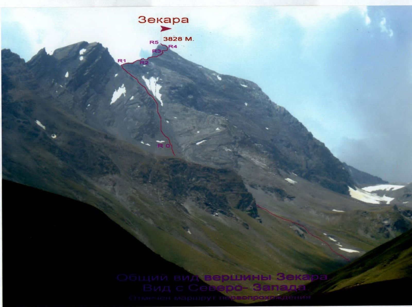
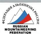
Description of the Ascent Route
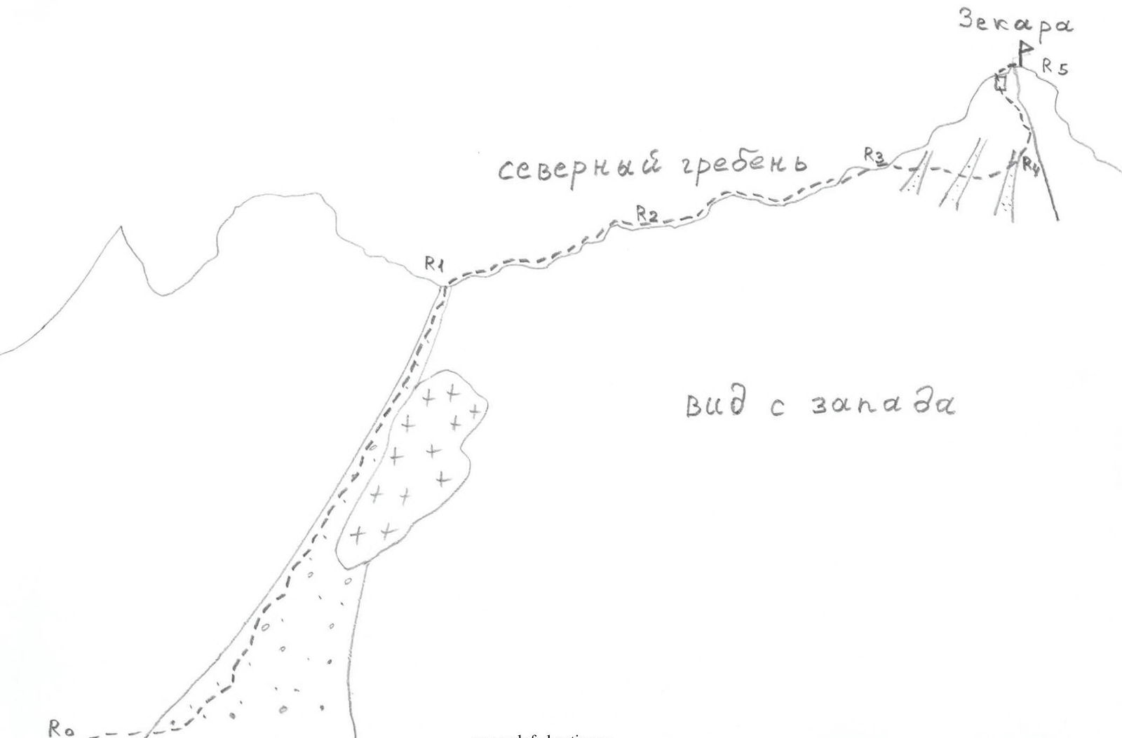
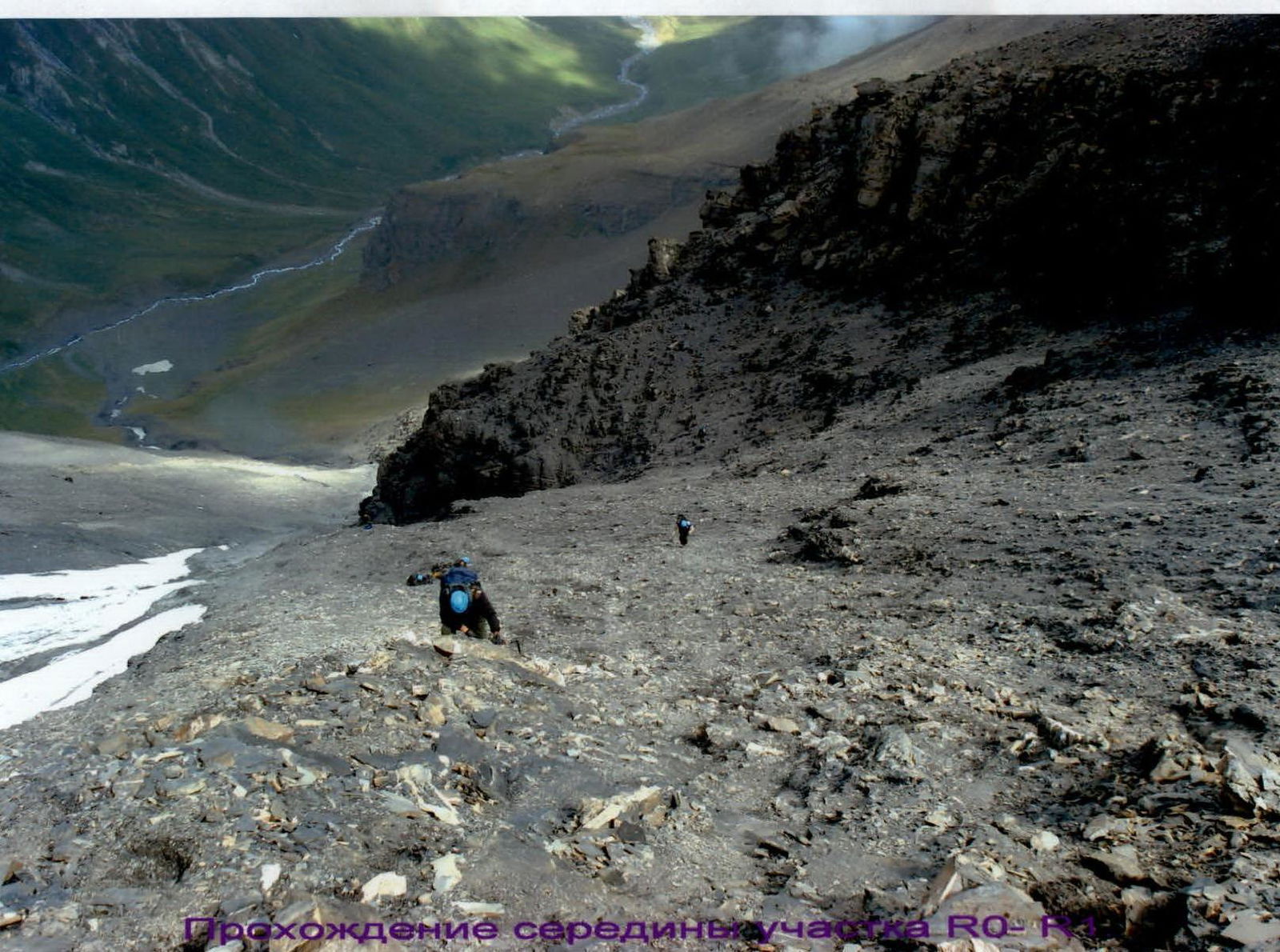
Section R0–R1: From the small cirque under the slate walls, located in the middle of the western slope of Zekara's North Ridge, ascend to the right.
Path:
- along the rocks on a slate talus;
- to the left is a visible saddle on the ridge ahead, towards which one should move;
- to the right is a couloir where rockfall from a small glacier on the western slope is possible.
Section characteristics:
- length: about 1 km;
- difficulty category: 1–2;
- steepness: 20–40°, at the top before reaching the saddle — up to 40°;
- surface type: talus turns into fine slate, difficult to traverse.
Recommendation: move along the left edge of the slope near the rocks.
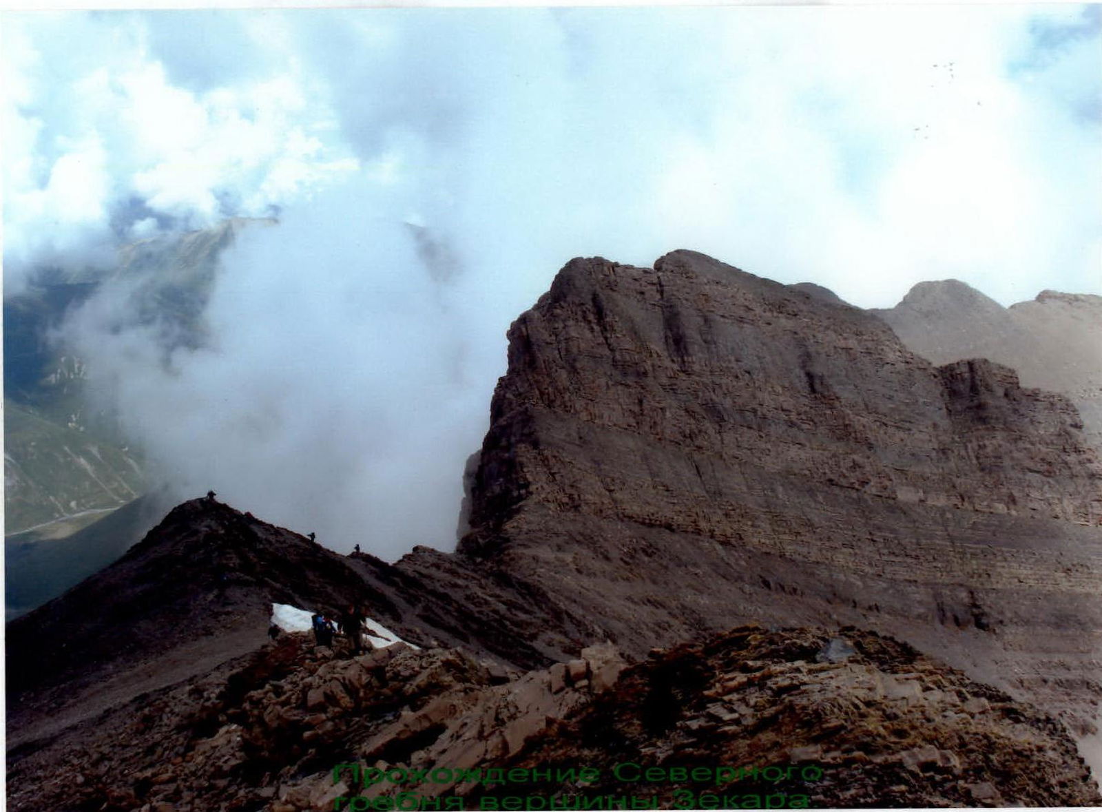
Section R1–R2: On the saddle, turn right and follow the destroyed rocks of category 1–2 along the ridge line to the saddle after the ascent. Section length 300 m, 20–40°.
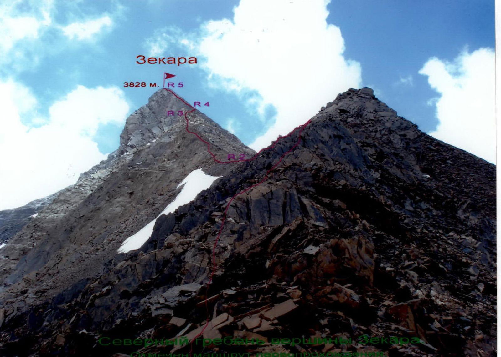
Section R2–R3: After a small saddle, a ridge of solid sandstone begins. Ascend along it to a steep ridge ascent. Reach it via a category 4 wall, 80°, 10 m. The entire section is about 300 m.
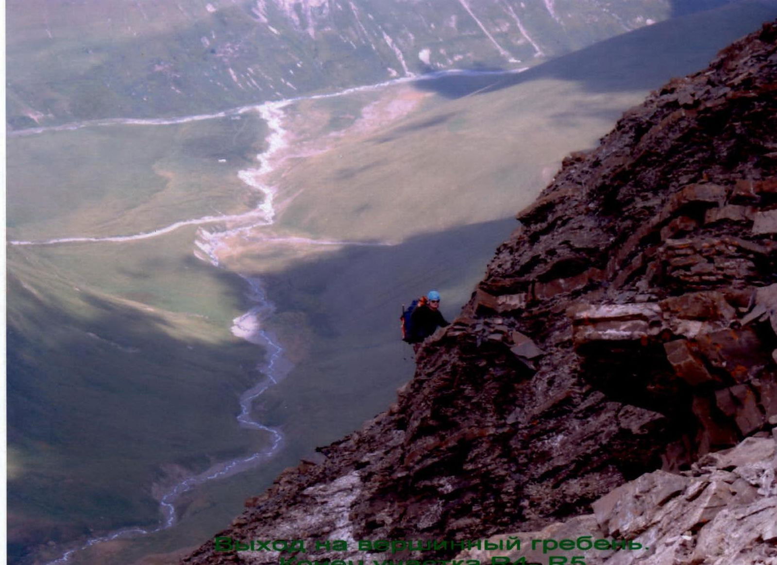
Section R3–R4: After the ascent, traverse the western slope to the right, towards a ridge visible against the sky. The traverse follows ledges, crossing small counterforts and snow-taluse couloirs.
Attention! Rockfall is possible from the left during the traverse.
Section characteristics:
- length: about 200 m;
- angle of inclination: 30–40°;
- difficulty categories: 1–2, местами 3.
Section R4–R5: Upon reaching the ridge descending westward from the summit, turn left and begin ascending towards Zekara peak.
- Follow rocks of category 1–2;
- Reach the North Ridge to the left of the summit tower;
- Access to the ridge is via a category 3 wall, 10 m, 60°;
- Turn right and ascend along the North Ridge to Zekara peak (3828 m).
The entire section is about 200 m.
The summit offers a good panoramic viewpoint, with the Tsey area and Teplinsky mountain junction visible.
From point R0 to the summit — about 5 hours.
Descent is via the ascent route.
Conclusions and Recommendations for the Route
The route traversed corresponds to the declared difficulty category. It can be recommended for traversal by training and sports groups.
Classification of the route will enable the start of sports development in the area, which is convenient for mountain training for border service employees, as this territory is their zone of responsibility.
Traversal of the route allows for the practice of rope skills. The rocks on the route are blocky in places, so it is recommended to have a set of chocks.
At the beginning of summer, on section R0–R1, a hard snow slope may be present early in the morning. Therefore, it may be necessary to bring crampons on the route.
It is convenient to start the route from the indicated overnight camps. The approach to the start of the route is convenient.
When moving along the talus couloir:
- it is necessary to move in a tight group to avoid dislodging stones onto each other.
On the route, belaying is necessary for training groups on sections of category 2 and above.
On the ridge, belaying can be done:
- through numerous rock outcrops;
- as well as using chocks.
Comments
Sign in to leave a comment