ASCENT FORM
- Ascent category: ice-snow
- Ascent region: Caucasus: 2.8: Genaldon River valley
- Peak, route: Geodesist Peak (4138 m): from NE via the glacier
- Estimated difficulty category – 3B, first ascent
- Route description:
- elevation gain – 500 m
- route length – 770 m
- length of 3B category sections – 640 m
- average slope of the main route section – 40°
- Pitons used:
- ice screws – 40 pcs.
- rock pitons – none
- other protective gear – none
- Climbing time/hours – 10/1
- Number of bivouacs:
- 1st – on the approach
- 2nd – on the descent
- bivouac at one location
- Leader: Levkovsky Yuri Vasilyevich – 1st sports category
Team members:
-
- Bondarenko Sergey Olegovich – 2nd sports category
-
- Bychkov Boris Nikolayevich – 3rd sports category
-
- Lunev Alexander Vladimirovich – 3rd sports category
-
- Salikov Sergey Vladimirovich – 3rd sports category
-
- Stadeev Nikolai Grigoryevich – 3rd sports category
-
- Coach: Proskuryakov Ruslan Pavlovich – Master of Sports
- Route start: August 27, 1994 Return to bivouac: August 27, 1994, 12:00
- Organization: KM FA RSO
Brief overview of the ascent region
The ascent region is located in the eastern part of the Central Caucasus, in the Genaldon River basin. Geodesist Peak (4138 m) is situated northeast of Mt. Shau-khokh and is a standalone panoramic peak with views of:
- Kazbek Plateau,
- Mt. Kazbek,
- Mt. Maili-khokh,
- Mt. Jimarai-khokh,
- Mt. Shau-khokh.
The region is part of the Republic of North Ossetia.
The peak is often visited by climbers via the previously established 1B category route from the Golda Glacier. Geological parties have conducted surveys in this area and built a road from the village of Tmenikau along the Genaldon River, which ends 1 hour's walk from the Maili Glacier.
Route description
From the corral in a grassy valley, ascend straight up: first, a steep grassy slope, then moraine hills littered with rock debris, to the "Geolog" pass – 4-5 hours. R0-R1
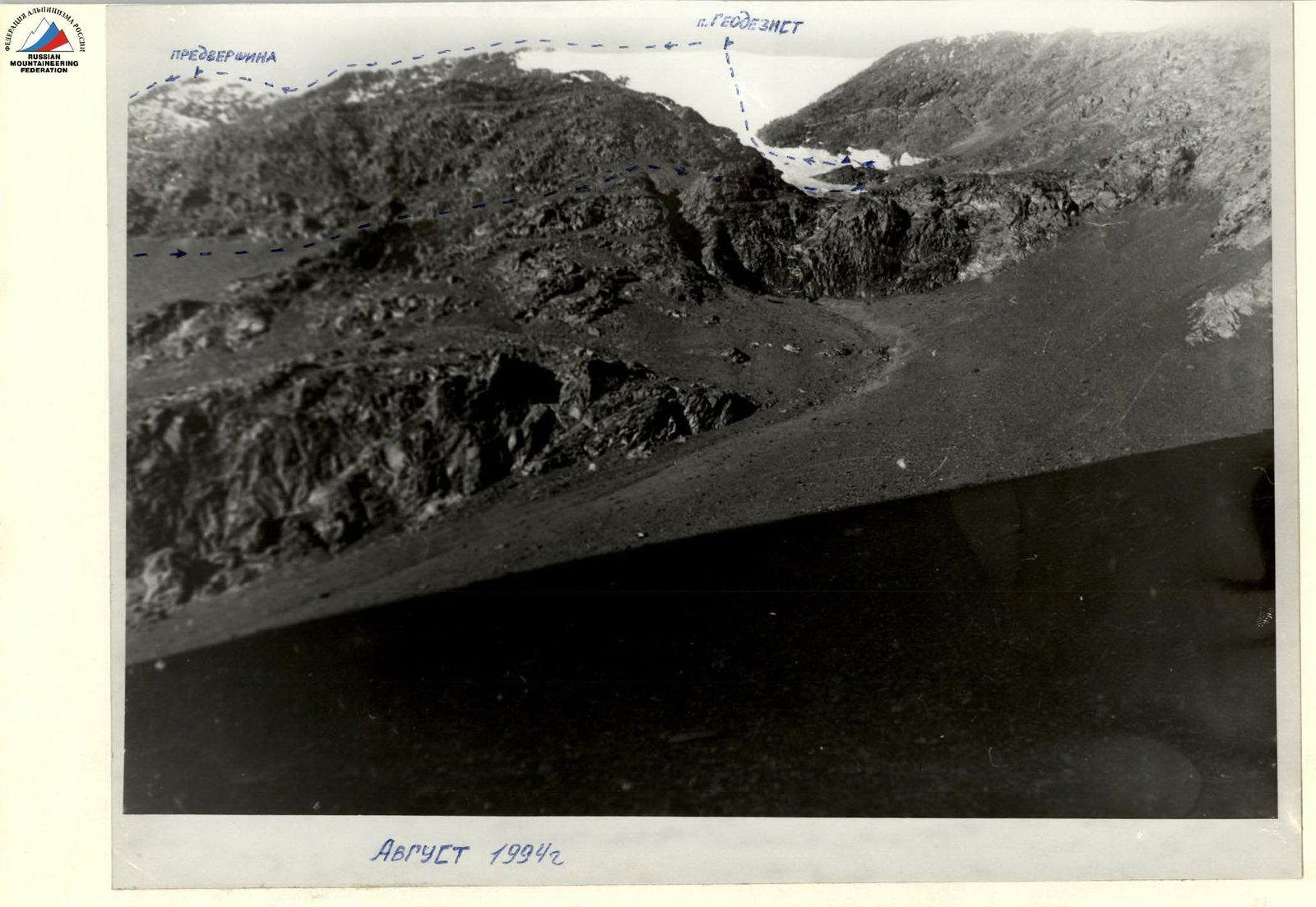
At the pass, turn right and move along a broad scree slope towards Geodesist Peak until reaching its subpeak – 1 hour. R1-R2. From the subpeak, descend 10 m via easy rocks to a narrow ridge, then traverse 20 m to the rocks on the crest (category 2 complexity): 50°, 40 m. Continue along easy crest rocks, bypassing a large gendarme on the left via a rock-scree ledge. R2-R3.
A short section of gentle snow ridge leads to the summit.
From the subpeak – 1 hour. Protection via rock outcrops. Descent follows the ascent route.
VIEW FROM THE NORTHEAST
Subpeak

Pre-ascent preparation
During preparation, the team conducted reconnaissance of the approach to the peak, determined the route orientation, made a preliminary assessment, and established radio communication principles.
It was determined that the best communication would be with Vladikavkaz using a VHF radio station, as there is a direct line of sight from the route, ensuring reliable radio communication at the bivouac and along the route.
Approach description
Travel: Vladikavkaz – "Karmadon" sanatorium:
- Take a regular bus.
- Continue on the road through the village of Tmenikau, over the corral above the Genaldon River.
- After 2 hours, the road descends to the river and disappears among the rocks.
Turn right and ascend the stream bed 80 m to a trail, which leads to a grassy valley with a corral – 30 minutes.
From the corral, ascend directly up the ridge of a grassy counterfort stretching along the stream.
After 1 hour:
- the grassy counterfort turns into scree with rock outcrops;
- after another hour of movement, the counterfort becomes gentler.
Leave the counterfort ridge to the right and down, traversing scree slopes, and follow a goat trail to a stream on rocky outcrops. This is a suitable bivouac site.
From the corral – 3 hours.
Route description
From the bivouac, move forward, traversing scree slopes and avoiding rocks, to the base of the glacier tongue – 1.5 hours.
The glacier is free of crevasses and is bounded on both sides by rocky counterforts (rocks are unstable); the lower section is prone to rockfall, while the upper section is safe.
Reach a large rocky outcrop beneath the glacier – a control cairn. From the rocky outcrop, ascend directly up the snow at the lower part of the glacier, which is 30° steep and littered with rocks, to a narrow section formed by converging counterforts – 100 m. Further up, the glacier steepens to 40° and maintains this slope until the middle section – 270 m.
Protection:
- Running belay
- Ice screws
In the middle section of the glacier, there's a brief (3 rope lengths) gentler slope at 30°, followed by another steepening to 40°. After 250 m, reach a snow dome (30°; 30 m) and ascend to the summit.
Route duration – 8-10 hours. Descend from the summit along the East Ridge to a distinct subpeak (category 2 rocks, running belay via outcrops) – 30 minutes, then left and down: first, across a scree slope, then via a scree couloir to the bivouac. From the summit – 1.5 hours.
The route, including the approach and return to Vladikavkaz, takes 2.5 days.
Recommendations
In summer, the route is relatively safe from snow avalanches; however, be cautious of small rockfalls from the unstable counterforts in the lower glacier section. In winter, beware of snow avalanches.
The route is logical and objectively safe with proper tactical planning; it is recommended for training and sports teams.