Ascent Record
- Ascent classification: winter.
- Ascent area: Caucasus, Lateral Ridge, Tsadjiudon gorge.
- Peak, route: Arkhon Maly (3984 m), via the Northwest Ridge and the right part of the North Face.
- Estimated difficulty category: 6A winter, first ascent.
- Height difference:
- 1135 m.
- of which the wall section is 250 m.
- length of the wall section — 255 m.
- total route length — 1680 m.
- of which: 5th difficulty category — 280 m, 6th difficulty category — 80 m.
- average steepness of the wall section — 79°
- average steepness of the route — 43°
- Pitons driven:
- rock pitons — 97
- ice screws — 3
- chocks — 0
- bolt pitons — 2 (for aid climbing)
- Duration/moving hours: — 29.5/4
- Overnights:
- 1st — on the ridge, comfortable, lying down.
- 2nd — at the base of the wall, comfortable, lying down.
- 3rd — on the Western counterfort, comfortable, lying down.
- Team leader: Egorin Sergey Vladimirovich — Candidate Master of Sports
Team members:
- Afanasyev Igor Oleg-Slavyanovich — Candidate Master of Sports
- Bondarenko Igor Olegovich — Candidate Master of Sports
- Glazov Alexander Petrovich — Candidate Master of Sports
- Ivanov Vitaly Valentinovich — Candidate Master of Sports
-
Coach: Khamitsaev Kazbek Borisovich — Candidate Master of Sports
-
Departure to the route: February 24, 1994.
Summit: February 27, 1994. Return: February 27, 1994.
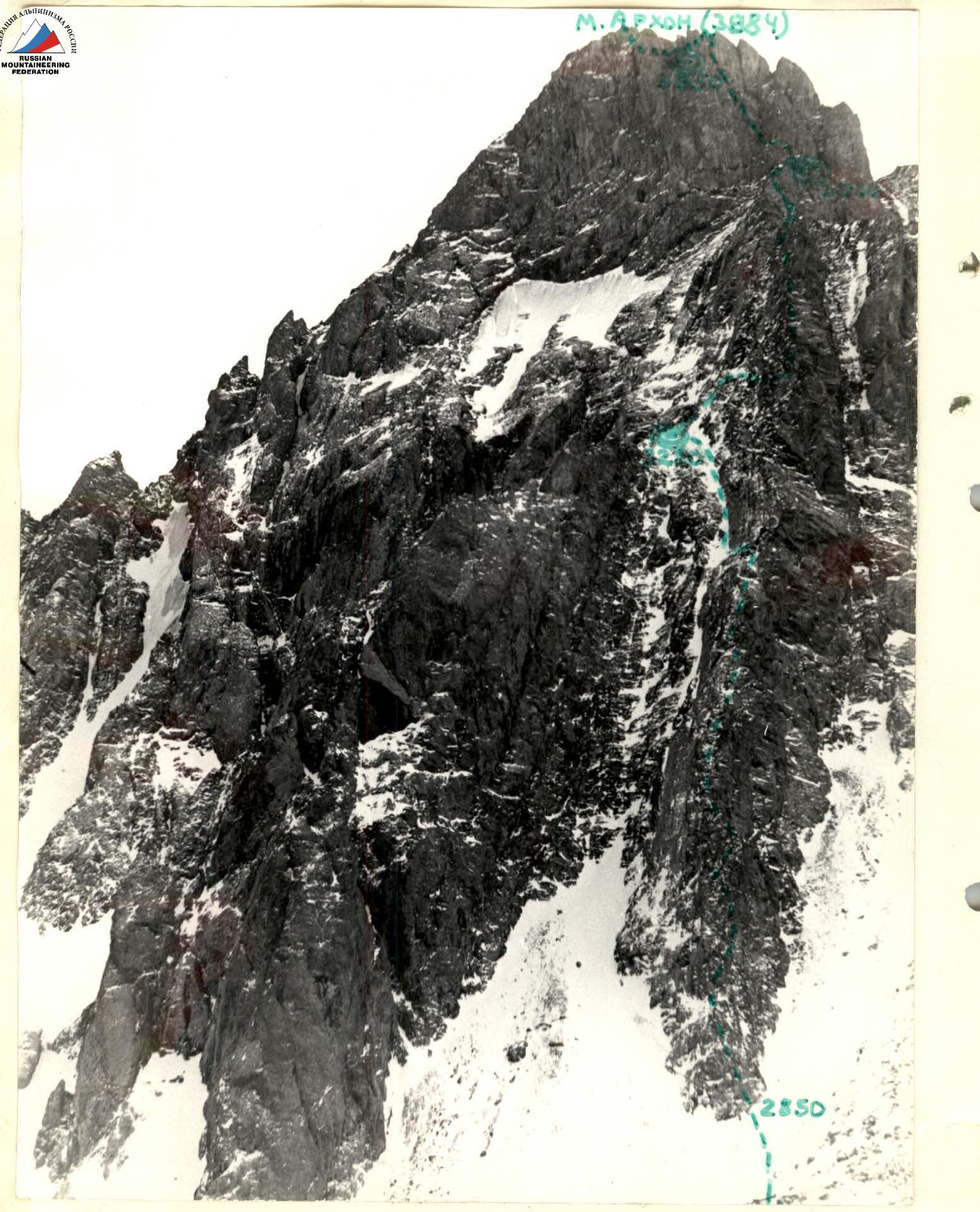
PHOTO #1. ARKHON MALY PEAK. Taken from the northwest, from the left-bank moraine of the Tsadjiu glacier, 2900 m, February 23, 1994, 15:00.
- Distance to the mountain: 2500 m.
- Lens: Industar 61 L
- Focal length: 50 mm.
- T. 1
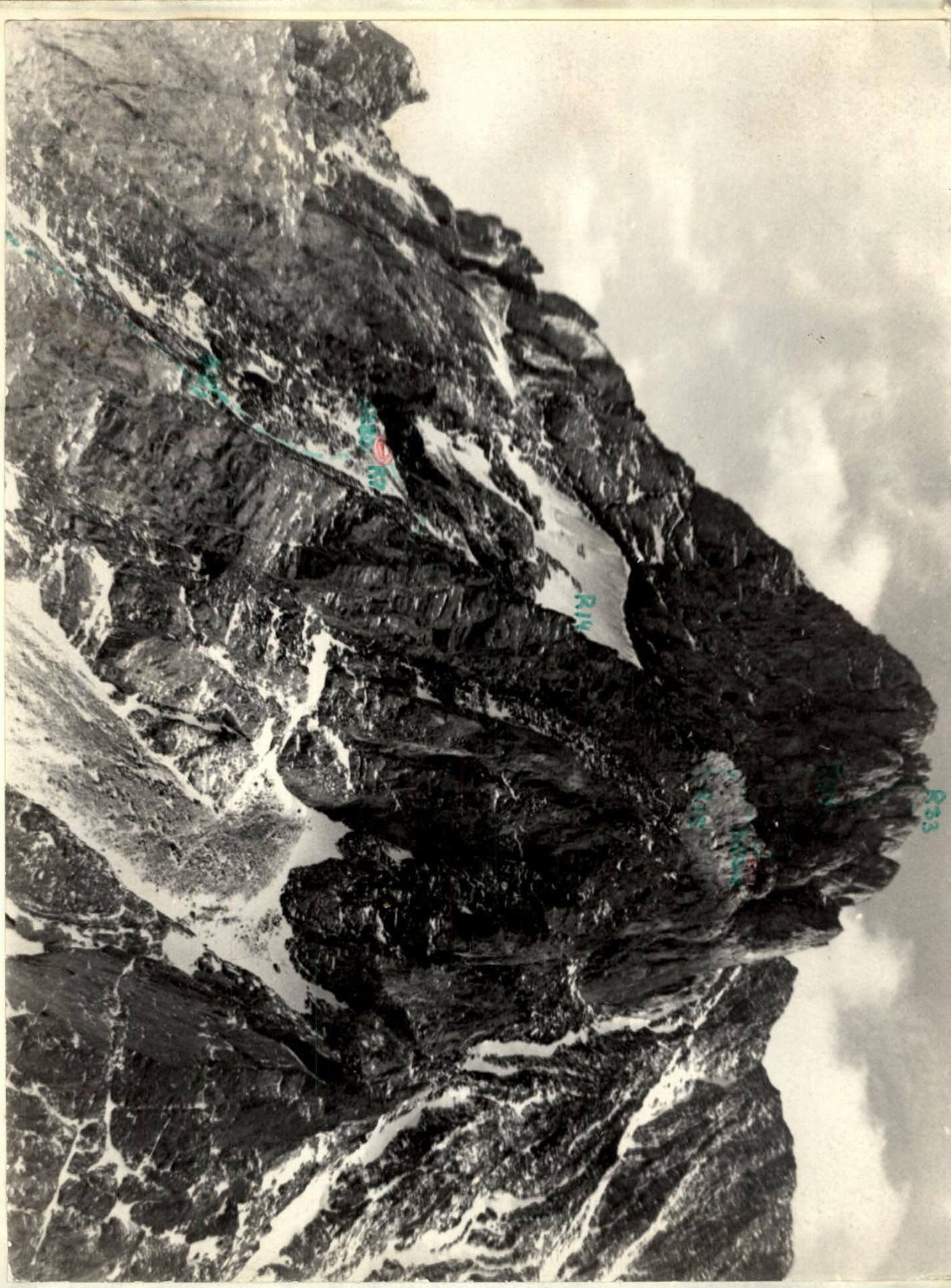
PHOTO #2. RIGHT WALL PROFILE. Taken from the Tsadjiu glacier, 2950 m, February 23, 1994, noon. Distance to the mountain 2500 m. Lens Industar 61 L, focal length 50 mm. T. 2.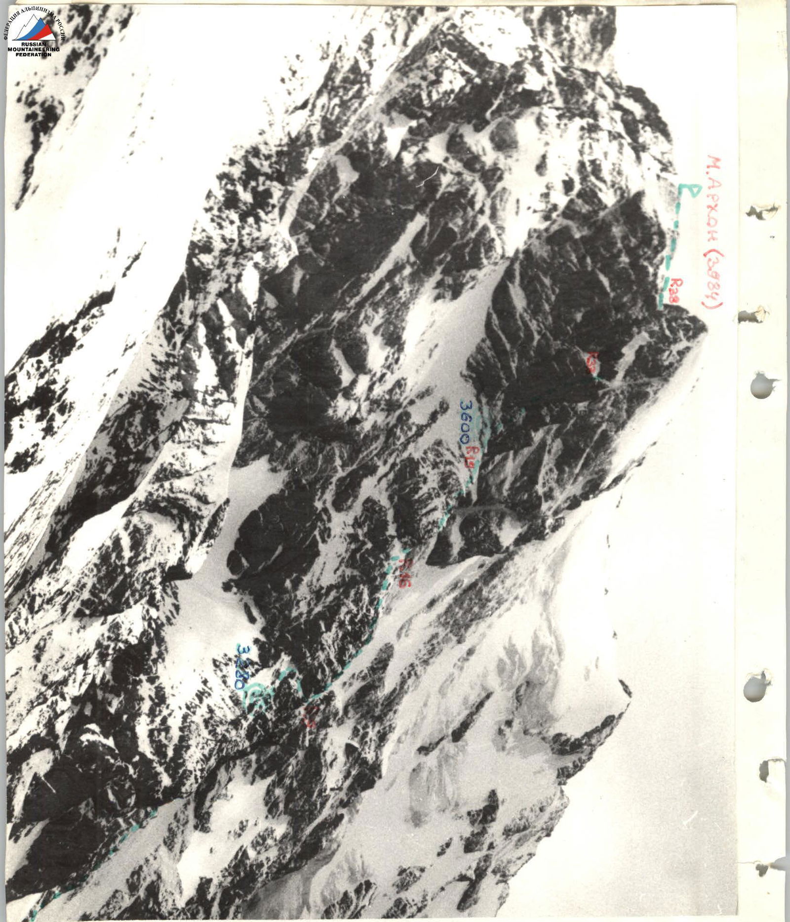
PHOTO #3. LEFT WALL PROFILE. Taken from the Tsadjiu gorge, May 1993, afternoon. Lens Industar 50, focal length 50 mm. Distance to the mountain 1500 m.
T. 3.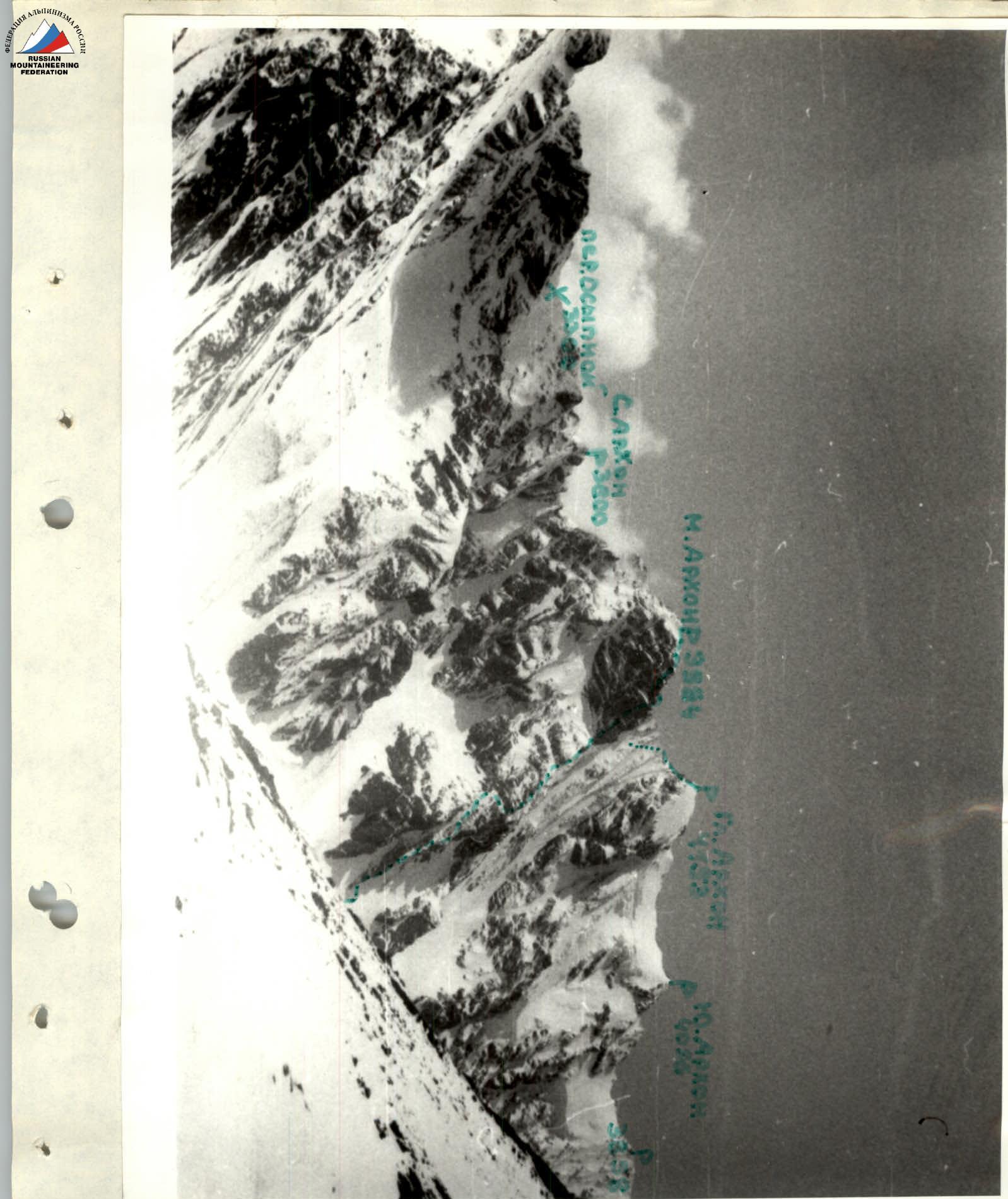
PHOTO #4. PHOTOPANORAMA OF THE AREA. Taken from the left ridge of the Tsadjiu gorge, 3050 m, June 1993, noon. Distance to the mountain 5000 m. Lens anastigmat T-43, focal length 40 mm.
T. 4. The ascent area is located in the central Caucasus — in the Tepli-Kolota mountain range, which is part of the Lateral Ridge system, in the Tsadjiudon river gorge. Geologically, this gorge is very interesting because the ridges surrounding it are mainly composed of crystalline rocks — granites and diorites. The rocks of the ridges and counterforts descending from the numerous peaks of this gorge are also of magmatic origin. However, at the same time, the couloirs leading to the saddles between the peaks are formed by heavily destroyed clay shales. Apparently, this gorge and some neighboring ones are a contact zone between magmatic and sedimentary rocks. The area is rarely visited due to its remoteness from alpine camps and its belonging to the North Ossetian State Reserve. From an alpinist's perspective, the Tsadjiudon gorge is very promising. There are only three classified routes in the gorge, although first ascents and first climbs of 2nd to 5th difficulty category are possible, either rock or combined.
Brief description of the approach to the route.
- Travel from Vladikavkaz city to Kharisdzhin village by bus — 1.5–2 hours.
- From the village, follow the dirt road upstream along the Fiagdon river gorge for 2 km to the mouth of the Tsadjiudon river.
- Follow the trail on the left side of the river upstream to the turn of the gorge to the left (south) — 1 hour.
- Continue along the old geological road through the forest, and above the forest, cross the ancient overgrown moraine ledge, then descend to the river river.")
- In the wide, practically horizontal riverbed on the right side — a lake visible from May to October. From the turn of the gorge — 2 hours.
- From the lake, Arkhon Maly is visible ahead.
- Follow the river to the steep moraine ascent — 45 minutes.
- Climb up the slope to the sharp right-bank (orographic) moraine running along the northern slopes of the Maly Arkhon peak — another 1 hour.
- Follow the moraine ridge for 0.5 hours, not reaching the point where it meets the large-block granite scree.
- From the scree, go left-upward to the start of the sharp, narrow Northwest Ridge — 20 minutes.
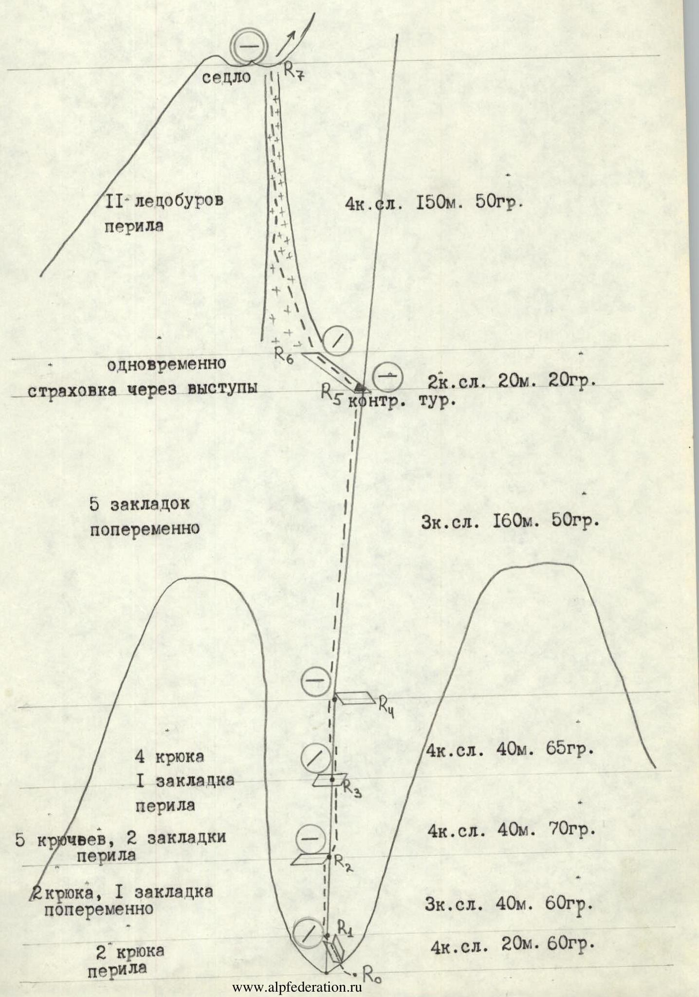
ROUTE SCHEME IN M 1:2000 SYMBOLS
-
2 pitons, 3 chocks alternately, 1/2 piton
-
6 pitons, 4 chocks, rope railing
-
1 piton, 6 chocks alternately
-
rope railing, 5 pitons, 5 chocks, 6 pitons, 6 chocks, rope railing
-
3 chocks
-
alternately 2 pitons
-
4 chocks
-
rope railing, 5 pitons
-
rope railing, 5 pitons, 3 chocks
-
rope railing, 5 ice screws
-
3 pitons
-
rope railing for rock outcrops
-
3+ category, 80 m, 45°
-
6 category, 5 m, 100° — ascent
-
5 category, 35 m, 80°
-
3+ category, 100 m, 40°
-
4+ category, 40 m, 60°
-
4–5 category, 40 m, 75°
-
3 category, 40 m, 30°
-
4–5 category, 30 m, 75°
-
4 category, 30 m, 30°
-
5 category, 30 m, 70°
-
4 category, 50 m, 15°
-
ledge with ice
-
3+ category, 60 m, 55°
-
2 category, 50 m, 20°
-
2 pitons, 2 chocks, loop
-
4+ category, 25 m, 75°
-
2 category, 30 m, 20°
-
10 ice screws, loop
-
2 category, 20 m, 20°
-
2 category, 20 m, 20°
-
loop, 5 pitons, 5 chocks
-
6/1s pitons, 5 chocks
-
loop, 3 pitons, 2 chocks
-
2 pitons, 3 ice screws, 1 piton, 1s + 1 pitons
-
2 ice screws, 4 pitons
-
7 pitons, 3 chocks
-
5 pitons, 2 chocks, 1 ice screw, 2 pitons
-
3 pitons, 2 chocks
-
4 pitons, 5 chocks
-
4 pitons, 3 chocks
-
alternately for rock outcrops
-
6 category, 45 m, 80°
-
6 category, 30 m, 90°, A1e
-
5+ category, 5 m, 85°
-
5+ category, 5 m, 65°
-
5 category, 15 m, 75°
-
6 category, 5 m, 90°, A2e
-
5 category, 20 m, 75°
-
6 category, 20 m, 87°
-
6 category, 20 m, 90°
-
3 category, 10 m, 20°
-
4 category, 25 m, 70°
-
5+ category, 20 m, 85°
-
5 category, 25 m, 85°
-
control cairn
-
3 category, 80 m, 30°
Approach the base of the narrow, upward-extending ridge on the right-bank moraine (orographic) of the Tsadjiu glacier. Height 2850 m.
R1–R2. Climb the ridge from the right (in the direction of travel) via a not clearly defined internal corner, 4 category, 20 m, 60°. Due to the narrow ridge, everyone moves in a line.
R1–R2. Move along the ridge line, 3 category, 40 m, 60°, to a comfortable ledge.
R2–R3. Climb another rope length, 4 category, 40 m, 70°, slightly to the right of the ridge line, to a small ledge that can accommodate only two people.
R3–R4. From the ledge, climb a steep 5-meter section, and then continue along the ridge line, 4 category, 40 m, 65°, to a large outcrop that provides convenient belaying.
R4–R5. The ridge steepness decreases, and the number of outcrops increases, allowing movement in pairs, alternately, 3 category, 160 m, 50°, to a comfortable ledge that extends to the left. Here is the first control cairn. Time from the start of the ridge: 4–6 hours.
R5–R6. Move left along the ledge, 2 category, 20 m, 20°, to an icy couloir.
R6–R7. Climb the steep couloir, 4 category, 150 m, 50° (ice screws, rope railing), upward. The couloir becomes less steep and leads to a narrow, scree-covered saddle. Time from the control cairn: 1.5 hours. Here is a bivouac. In the remaining time, the pair processed another 4 rope lengths.
R7–R8. From the saddle, move right along a small ridge that transitions into a wall, 3+ category, 60 m, 55°, alternately (belaying from rock outcrops), to an icy ledge. Before the ledge, there is a convenient outcrop where the rope railing was anchored.
R8–R9. From the outcrop, move right along a narrow ledge with rime ice, 4 category, 50 m, 15° (ice screws). By the end, the ledge widens and leads to a ridge. Here is a comfortable spot that can accommodate 5 people.
R9–R10. From the ledge, climb a wall on the ridge, 4 category, 30 m, 70°, bypassing the first pinnacle on the left, to an uncomfortable depression for one person.
R10–R11. From the depression, continue along the ridge via slabby, smoothed rocks, 4 category, 30 m, 30° (thin pitons), to the second pinnacle.
R11–R12. Climb the pinnacle via a wall, 4–5 category, 30 m, 75°. On top of the pinnacle, there is a rock with a hole, making it easy to set up a belay station.
R12–R13. After the pinnacle, move right of the ridge line along large-block rocks with many cracks, 3 category, 40 m, 30°, to a ledge under the third pinnacle.
R13–R14. Climb the pinnacle from the right via an internal corner, 4–5 category, 40 m, 75°, to a ledge behind the pinnacle.
R14–R15. From here, move along the ridge, 4 category, 40 m, 60°, which takes the form of a "saw" with 2–3 meter drops, and the last ascent is a 6–7 meter wall with few smoothed holds. After the "saw," there is a comfortable, wide ledge.
R15–R16. From the ledge, move along rocks, 3+ category, 100 m, 40°, left of the ridge line (belaying mainly from rock outcrops), to a comfortable ledge on the right side of the ascent. Here is a possible overnight stay.
R16–R17. The ascent is preceded by a steep wall, 5 category, 35 m, 80°, with smoothed, small holds.
R17–R18. After the wall, there is a 1-meter overhang, 6 category, 5 m, 100°, A2. Due to the high exposure and lack of snow on the ascent, the first climber went in crampons without a backpack, using hook-nails.
R18–R19. After the ascent, move along the ridge line, 3+ category, 80 m, 45°, alternately, with belaying mainly from rock outcrops.
R19–R20. The ridge steepness decreases, and movement continues along the ridge, 3 category, 80 m, 30°, to a comfortable ledge under the North Face. Here is the second control cairn and a bivouac. Time from the first bivouac: without prior processing — 7–8 hours, with prior processing of 4 rope lengths (R7–R11) — 5 hours. In the remaining time, the pair processed another 3 rope lengths on the wall (R20–R26).
R20–R21. From the ledge, climb straight up a steep wall, 5 category, 25 m, 85°, with a configuration of cracks allowing the use of chocks of small and medium sizes. The wall leads to a steep, inclined ledge with rime ice (ice screw).
R21–R22. After the ledge, there is another wall with a wide (up to 20 cm) crack. Climb up, 5+ category, 20 m, 85°. After the wall, there is a comfortable, wide ledge. Here is a belay station.
R22–R23. From the ledge, climb a smoothed wall, 4 category, 25 m, 70° (thin pitons), to an icy ledge.
R23–R24. Here, move left along the icy ledge, 3 category, 10 m, 20° (ice screw). The ledge leads to a narrow couloir, before which there is a large outcrop that can be used to set up a belay station.
R24–R25. From the outcrop, cross the narrow couloir (2 m) and climb an отвесному заглаженному камину шириной 80–90 см, 6 category, 20 m, 90°. The bottom of the chimney is covered with red moss, making it slippery, but unlike the smoothed sides, there are cracks where pitons can be driven and even large holds can be used. After 10 meters, the steepness of the chimney decreases, and more holds become available. At the top, there is a small ledge on the left side of the chimney, and by bypassing it on the right, you can exit onto a small ledge above it.
R25–R26. From the ledge, climb a steep wall, 6 category, 20 m, 87°. Cracks are narrow and scarce, all holds are small but precise. There is an opportunity to bypass this wall via a steep, narrow chimney located 2 meters to the left, but at the moment, there was rime ice in the chimney. After the wall, there is a small ledge for two people, here is a belay station.
R26–R27. From the ledge, move 2 meters to the left to a wide chimney (up to 3 m wide), and climb up, 5 category, 20 m, 75°, to an overhanging plug. Movement typically occurs along the bottom of the chimney, which is covered with rime ice (ice screws). Observation of the partner is challenging on this section.
R27–R28. Bypass the overhanging plug along the right side of the chimney, 6 category, 5 m, 90°, A2. Here, a bolt piton was driven for aid climbing, and another thin rock piton was driven. After the wall, exit onto a plug covered with ice.
R28–R29. From the plug, climb the chimney, 5 category, 15 m, 75°. The bottom of the chimney has rime ice (ice screws). The chimney leads to a second plug.
R29–R30. Bypass the plug on the left through a small overhang, 5+ category, 5 m, 85°. Rocks are smoothed with narrow cracks. On top of the plug, there is rime ice. Here is a belay station.
R30–R31. From the plug, a narrow chimney with rime ice ascends. However, due to the chimney's overhanging upper section, move along the wall to the left of the chimney, 5+ category, 15 m, 85°, to a small ledge. CAUTION! The ledge has loose rocks.
R31–R32. From the ledge, a wall ascends, 6 category, 30 m, 90°. This is a psychologically challenging section. Initially, the wall is slightly overhanging, and a bolt piton was driven for aid climbing. Further, the wall becomes less steep, and more holds appear, although they are small. There are cracks suitable for both chocks and various pitons. Movement is hindered by loose (unreliable) holds. The wall leads to a small niche for one person, here is a belay station.
The described three rope lengths (130 meters) R30–R32 constitute the most challenging part of the route and are its crux.
R32–R33. From the niche, move upward along an internal corner with a wide (20 cm) vertical crack, 5 category, 45 m, 80°. Rocks are destroyed but have various cracks suitable for chocks and pitons. Observation from the niche is challenging, but its upper overhang provides protection from falling rocks. The chimney leads to the Western counterfort. Here, the rock section of the route ends, and on the ledge, there is the third control cairn. Time from the second overnight stay: without prior processing — 11 hours, with prior processing of three rope lengths (R20–R24) — 8 hours.
R33–R34. From the control cairn, move right of the Western counterfort along a ledge, 2 category, 20 m, 20°, to a platform. Here is a bivouac.
R34–R35. From the platform, follow a ledge, 2 category, 20 m, 20°, to approach a couloir.
R35–R36. Climb the icy couloir, 4 category, 80 m, 45°. In the lower third of the couloir, there is a rock plug that can be bypassed on the right via rocks, 4 category. In the upper section, ice lies in a thin layer on a rock substrate; here, ice screws do not turn — belaying is done from the rock sides of the couloir.
R36–R37. Move left along a ledge, 2 category, 30 m, 20°, to a small wall leading to the Western counterfort.
R37–R38. Climb the wall, 4+ category, 25 m, 75°, upward onto the Western counterfort. The wall is composed of large-block granite with wide cracks (pitons, chocks).
R38. Follow a simple, gentle Western counterfort, 2 category, 160 m, 20°, to reach the summit of Arkhon Maly (3984 m). Time from the third control cairn: 2.5–3 hours.
Descend along an scree slope to the south to the first couloir. Follow a snow-covered eastern couloir (alternately) and further along snow-scree fields, descend into the Fiagdon river gorge (estimated 2A category). Time from the summit to the gorge: 2.5–3 hours.
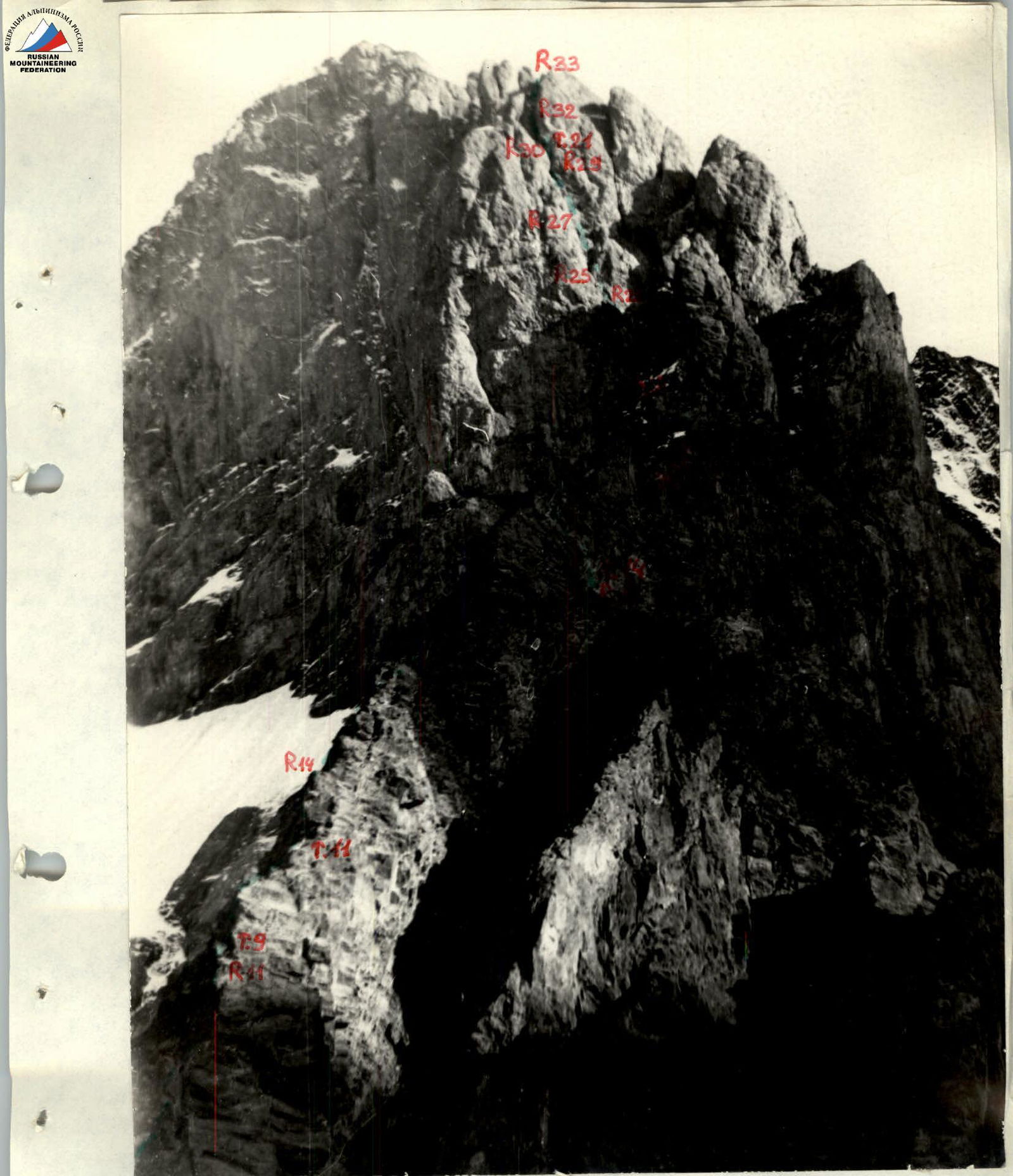
PHOTO #5. TECHNICAL PHOTOGRAPHY OF THE ROUTE. Taken from the left bank of the Tsadjiu glacier, August 23, 1993, 18:30. Distance to the mountain 2500 m, shooting height 2950 m. Lens Jupiter II, focal length 135 mm. T. 5
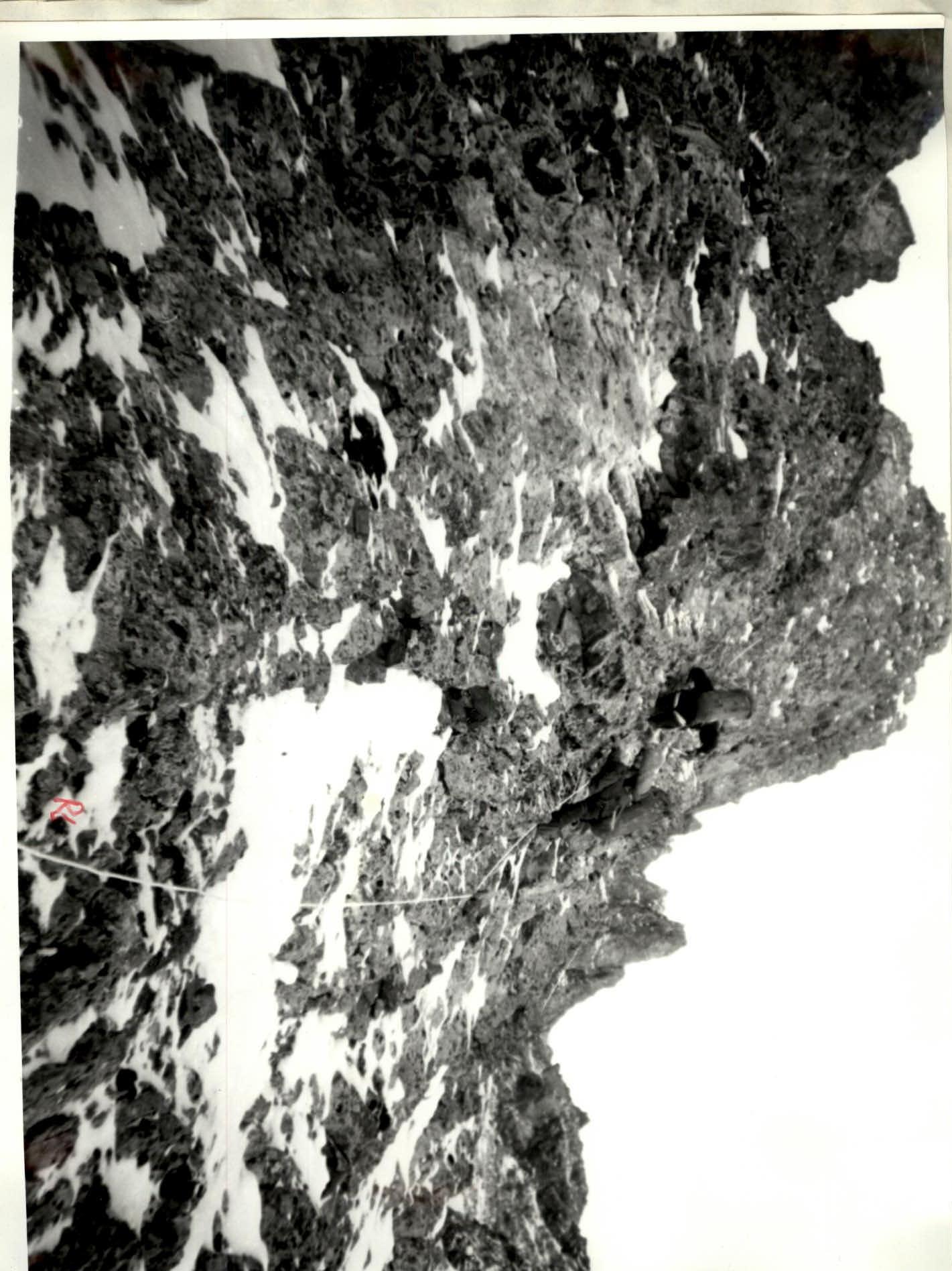
PHOTO #6. Alternating movement on R1–R2. February 24, 10:30.

PHOTO #7. Climbing on fixed ropes. R7–R8.
February 25, 1:30.
T. 6.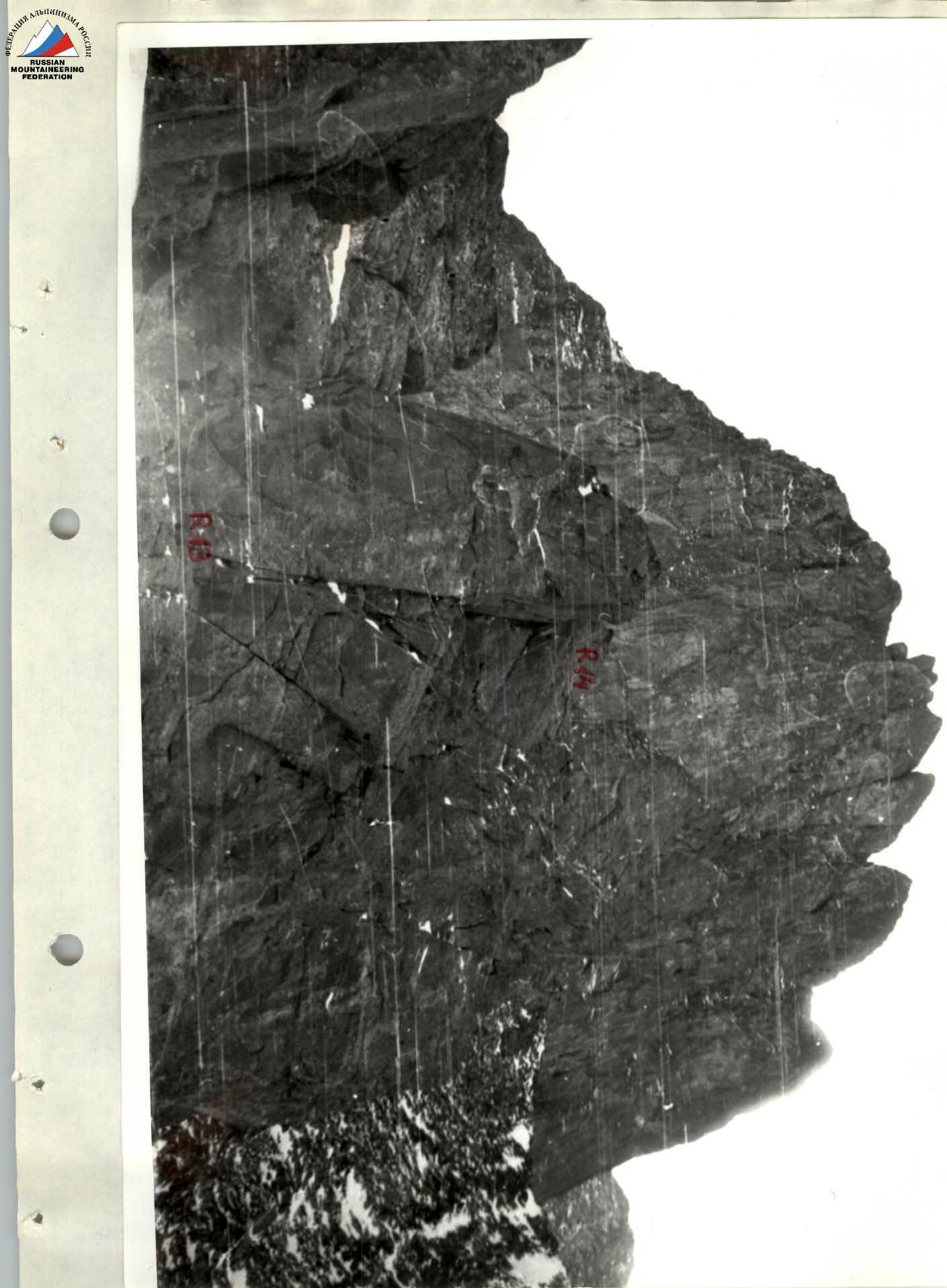
PHOTO #11. Movement on fixed ropes. R13–R14.
February 25, 11:30.
T. 11.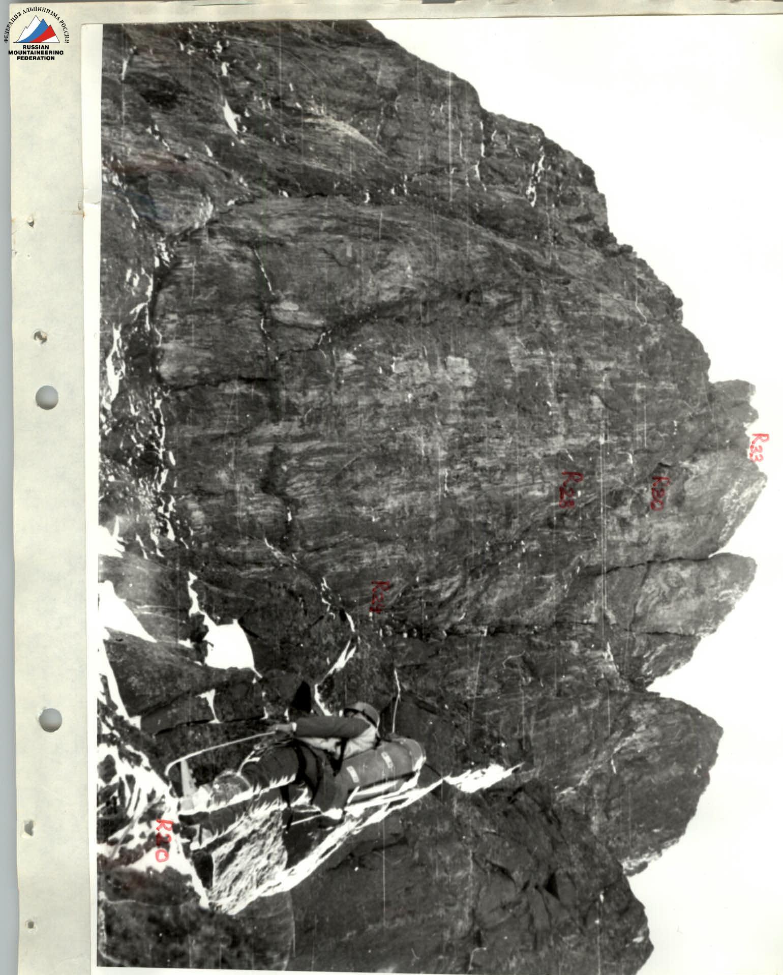
PHOTO #15. View of the right part of the North Face. R20.
February 25, 16:30.
T. 15.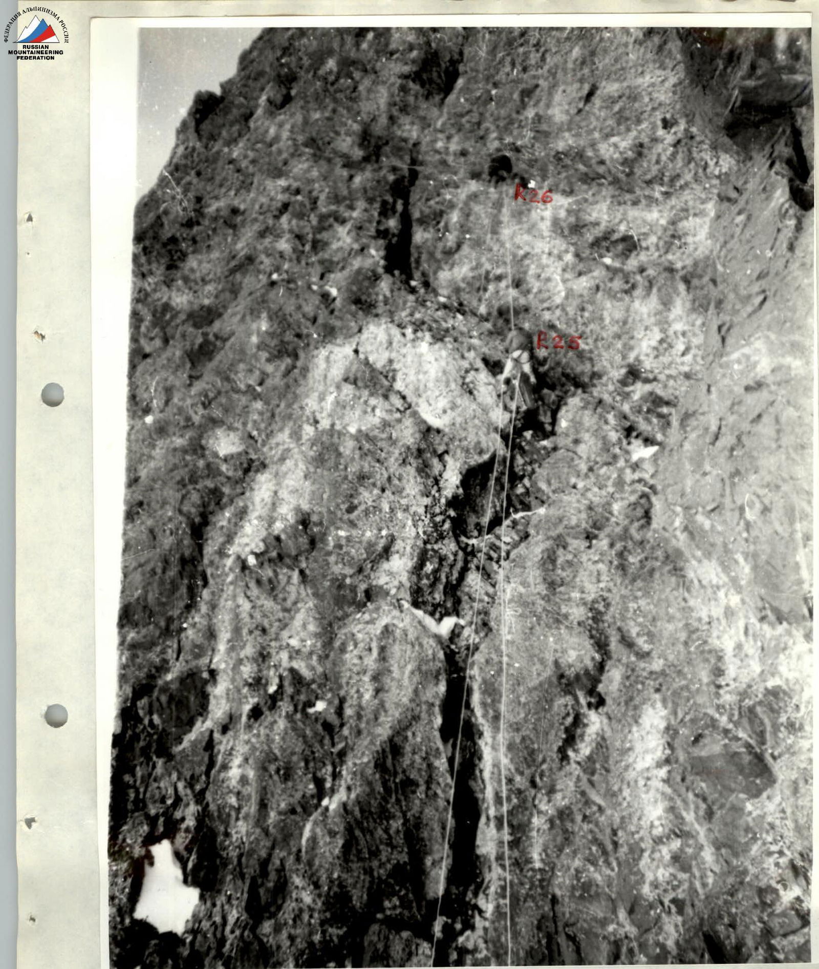
PHOTO #18. Climbing on fixed ropes. R24–R25. February 26, 11:00.
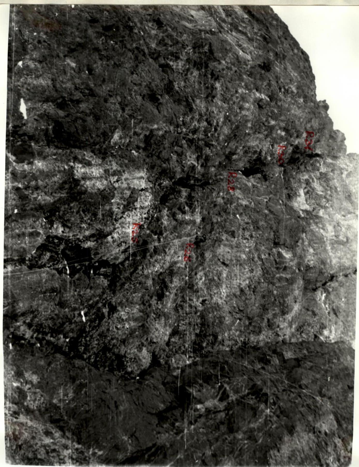
PHOTO #19. View of the middle part of the wall. R24–R30. February 26, 10:00. T. 19.