ASCENT LOG
- Ascent category - rock climbing
- Ascent area - Caucasus (2.7 from Gurdziptsек pass to Mamison pass)
- Peak, its height, and ascent route - peak Khitsan, 3600 m, via the North face and North-West ridge
- Proposed category difficulty - 3B
- Route characteristics: Height difference - 400 m Length of sections with 4th-5th category difficulty - 55 m Average steepness - 58°
- Number of pitons: for belaying, for creating Intermediate Technical Objects (ITO) Rock pitons - 32, for ITO - 1 Ice screws - 2 Chocks - 7
- Number of climbing hours - 8
- Number of nights and their characteristics - none
- Group composition: Tarasevich Vladimir Konstantinovich - 1st sports category (leader) Voskoboynikov Fedor Egorovich - 1st sports category Pisarev Alexander Grigorievich - 1st sports category Romanenko Pavel Pavlovich - 1st sports category Serdyuk Oleg Nikolaevich - 1st sports category Shevchuk Alexander Gaevich - 1st sports category
- Team coach: Master of Sports of the USSR Volynsky Vitaly Alexandrovich
- Date of departure and return - August 26-28, 1980
Khitsan via the North face and North-West ridge
From the starting point (KSP) of the Tsey region, take the highway, turn left towards the Nazdon River: cross the Nazdon River via the bridge, then proceed along the Tseydon River. After crossing the Tseydon River via the bridge, turn left and follow the old road, then the trail in the forest on the right bank of the Tseydon River, ascending through the gorge. Upon exiting the forest, the trail approaches a large boulder near the right-bank moraine of the Tsey glacier, not far from its tongue. From the boulder, follow the right-hand trail to ascend to the moraine ridge and continue along the trail upwards through the gorge. After crossing the " рукава" (branches) of the Uilpatinka at the Lower Ice camps via the moraine ridge and grassy slopes, reach the Upper Ice camps. From the KSP of the Tsey region, it takes 2 hours. Then, follow the trail to approach the "бараньи лбы" (ram's foreheads) to the right of the First stage of the Tsey glacier's icefall. Ascend to the "бараньи лбы" via the trail and exit onto the scree above the icefall. Via the trail on the scree, ascend leftwards and upwards to reach the Tsey glacier. Cross it diagonally leftwards and upwards, beneath the icefall of the North branch of the glacier, approach the right side of its South branch and ascend along it to the right-bank moraine on the southern slopes of the Eastern ridge of peak Khitsan. On the moraine, 40-50 meters above the glacier, stands the Tsey hut. From the KSP of the Tsey region, it takes 3.5-4 hours. Passing the hut and ascending along the right side of the South branch for 100-150 meters, turn right into the first scree couloir and ascend via the trail within it to the Khitsan pass. Descend from the pass onto the glacier (crampons) and diagonally leftwards and downwards, avoiding numerous crevices, approach the base of the North face of peak Khitsan. The further description of the route is given in sections, as a brief explanation to the table.
R1. From the glacier, ascend a snow-ice slope with a 40° steepness, avoiding crevices, to reach the bergschrund (crampons). Cross the bergschrund beneath the rock islands of the North face of peak Khitsan, 50-70 meters left of the base of the North-West ridge. From the bergschrund, ascend 40 meters up the snow-ice slope to the rock islands. R2. Ascend the rock islands simultaneously with belaying via ledges, rightwards and upwards, to a wall with a pronounced chimney-crack - the first black rock belt. R3. Climb the chimney (5 meters) via the right wall with difficult climbing (piton belay, chocks) and exit onto a small ledge. R4. From the ledge, ascend upwards through moss-covered rocks of moderate difficulty, belonging to the light rock belt, to approach the 2nd black rock belt, above which lies a ledge with 1 control cairn (piton belay and via ledges). R5. 60 meters of monolithic rocks on the wall to exit onto the shoulder of the North-West ridge (piton belay, chocks). R6. From the shoulder, ascend leftwards and upwards via a rusty wall with outcrops in the lower right part and further upwards via a crack to a small ledge (key location, piton belay, chocks, possible use of a ladder). R7. 30 meters of rocks with moderate difficulty to beneath the rusty wall - 2 control cairns. R8. Traverse the wall on the left via a ledge. From the ledge, ascend directly upwards via boulders and then via a wall with a chimney in the left part (pitons, chocks). R9. Then, traverse leftwards to the end of the chimney via slabs with good holds to an "outcrop" in the upper part of the chimney. Further, 60 meters of simple, destroyed rocks to beneath the Black gendarme. R10. Traverse the gendarme on the right via a steep earth couloir - 30 meters. R11. 120 meters leftwards and upwards via a couloir to the pre-summit ridge. R12. 20 meters descent via a ledge. R13. Ascend upwards via a scree couloir for 40 meters to the rocks of the pre-summit tower. R14. Ascend simple rocks of the summit tower to reach the summit (40 meters), simultaneous movement. Descent via the Eastern ridge, category 1B difficulty, to the Khitsan pass.
| Date | Designation | Average angle | Length (m) | Terrain characteristics | Difficulty (category) | Condition | Rock condition | Rock pitons | Ice screws | Chocks |
|---|---|---|---|---|---|---|---|---|---|---|
| O–IА | 40 | 40 | ice, slope | 2 | ice | good | - | 2 | - | |
| 87. | IА–I | 40° | 40 | rock island | 1 | destroyed rocks | "-" | - | ledges | - |
| 88. | I–II | 70° | 15 | chimney | 4 | monolithic rocks | "-" | 3 | - | 1 |
| II–III | 60° | 25 | wall | 3 | "-" | "-" | 6 | - | - | |
| III–IV | 60° | 60 | wall | 3 | "-" | "-" | 9 | - | 2 | |
| IV–V | 90° | 20 | wall, crack | 5 | "-" | "-" | 5 | - | 2 | |
| V–VI | 60° | 30 | wall | 3 | rocks of medium | "-" | 4 | 4 | - | |
| strength | ||||||||||
| VI–VII | 80° | 20 | chimney | 4 | "-" | "-" | 2 | - | 2 | |
| VII–VIII | 50° | 60 | wall | 3 | destroyed rocks | "-" | 3 | - | 2 | |
| VIII–IX | 45° | 30 | couloir | 2 | scree with earth | "-" | - | - | - | |
| IX–X | 50° | 120 | couloir | 2 | "-" | "-" | - | - | - | |
| X–XI | -20 | 20 | ledge | 1 | rocky scree | "-" | - | - | - | |
| XI–XII | 20° | 40 | couloir | 1 | "-" | "-" | - | ledges | - | |
| XI–XIII | 20° | 40 | tower | 1 | boulders | "-" | - | ledges | - | |
| 560 | 32 | 2 | 7 |
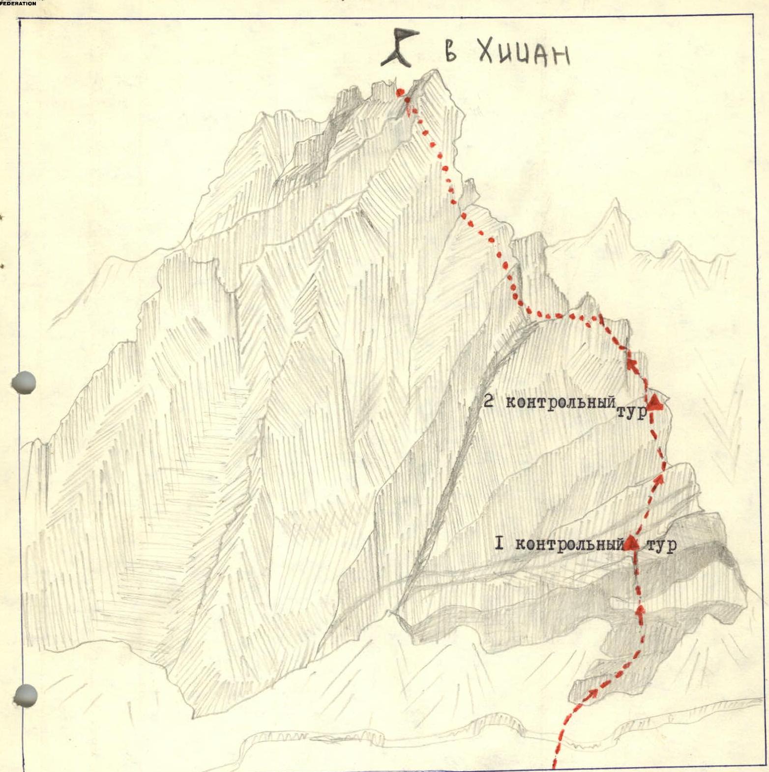
Graphical representation of peak Khitsan and the ascent route visible part of the route invisible part of the route