Ascent Passport.
- Caucasus. Rocky Ridge. Kionsky massif. Section number in Classification 2.7.
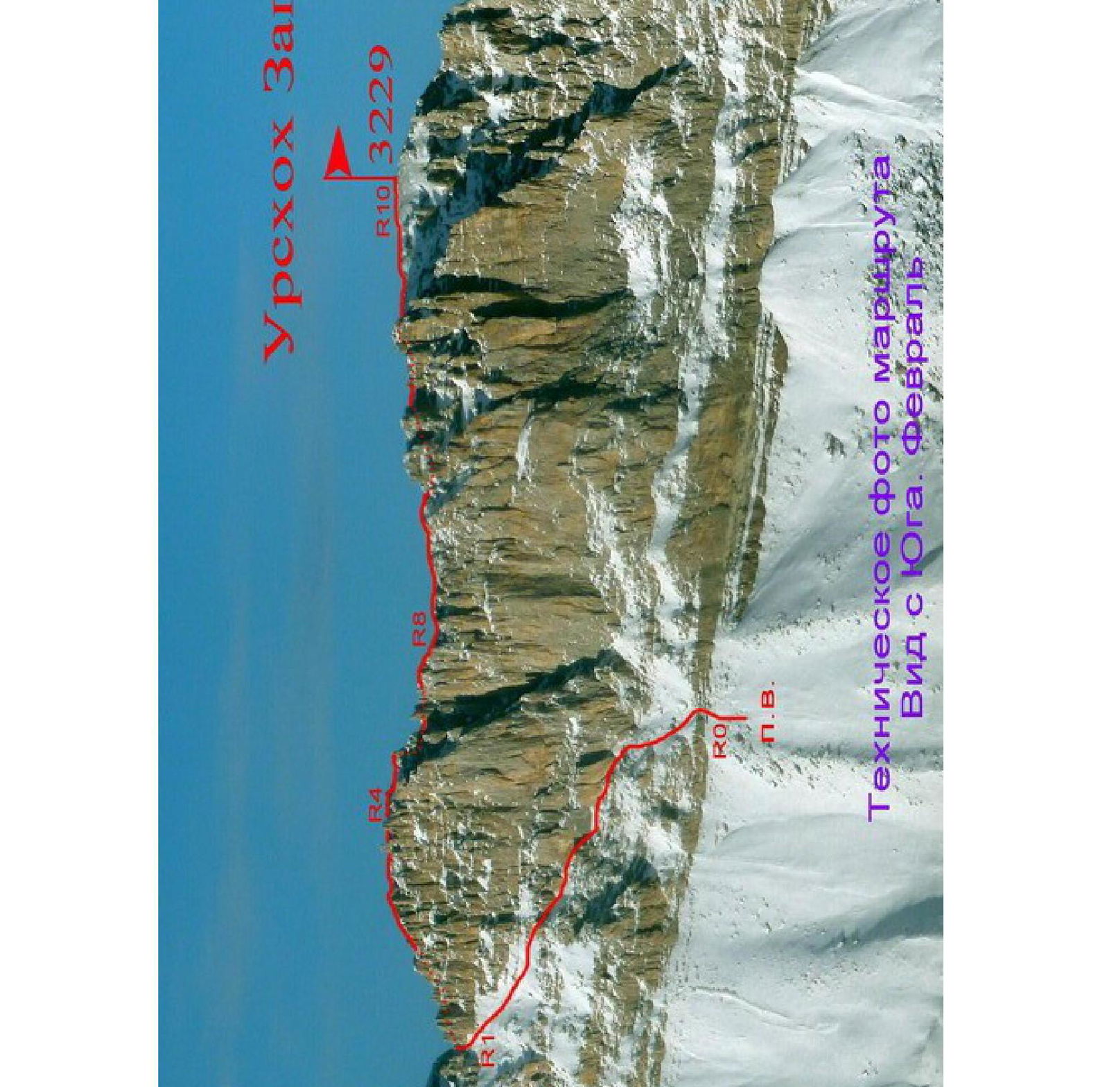
- Urshoch Zap. (3229 m) — from the South, along the Western ridge.
- Proposed 2B cat. diff., first ascent.
- Route character — rocky.
- Route height difference — 450 m (by GPS).
Total route length — about 1200 m. Length of sections with 3–4 cat. diff. — 50 m. Steepness of key sections — up to 70°. Average route steepness — 30°.
- Hooks left on the route — none.
- Walking hours — 6; days — 1.
- Leader: Egorin S. V. — Master of Sports.
Participants: 4 special unit employees.
- Coach: Egorin S.V. — Master of Sports
- Departure to the route, ascent, descent: August 14, 2013.
- Organization: North Ossetian Search and Rescue Team, EMERCOM of Russia.
- Leader's contact information for inquiries about the report:
phone: +7 928 490–31–28; email: e.s.128@mail.ru.
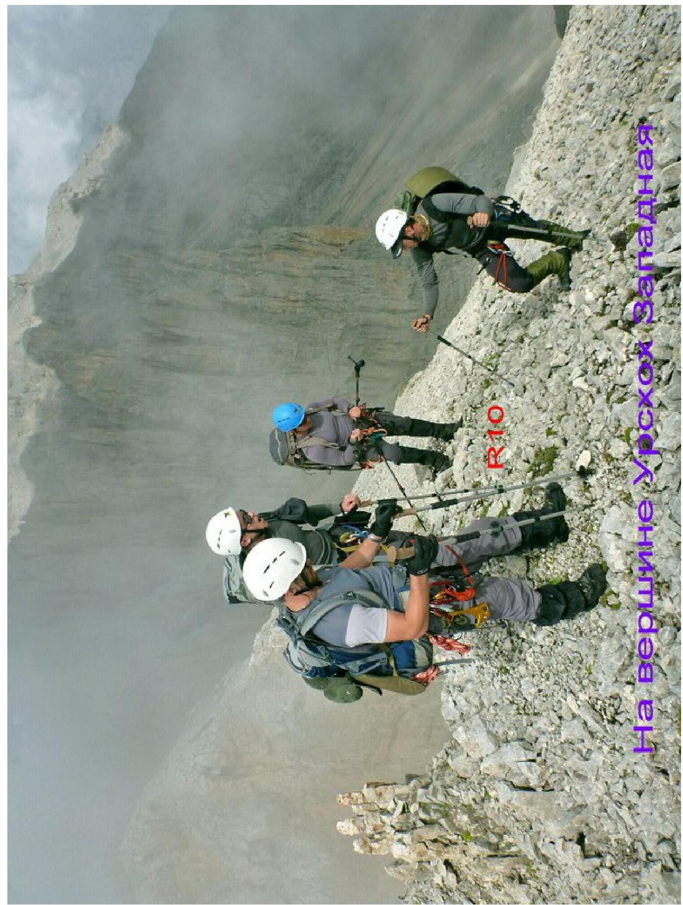
Urshoch Zap.
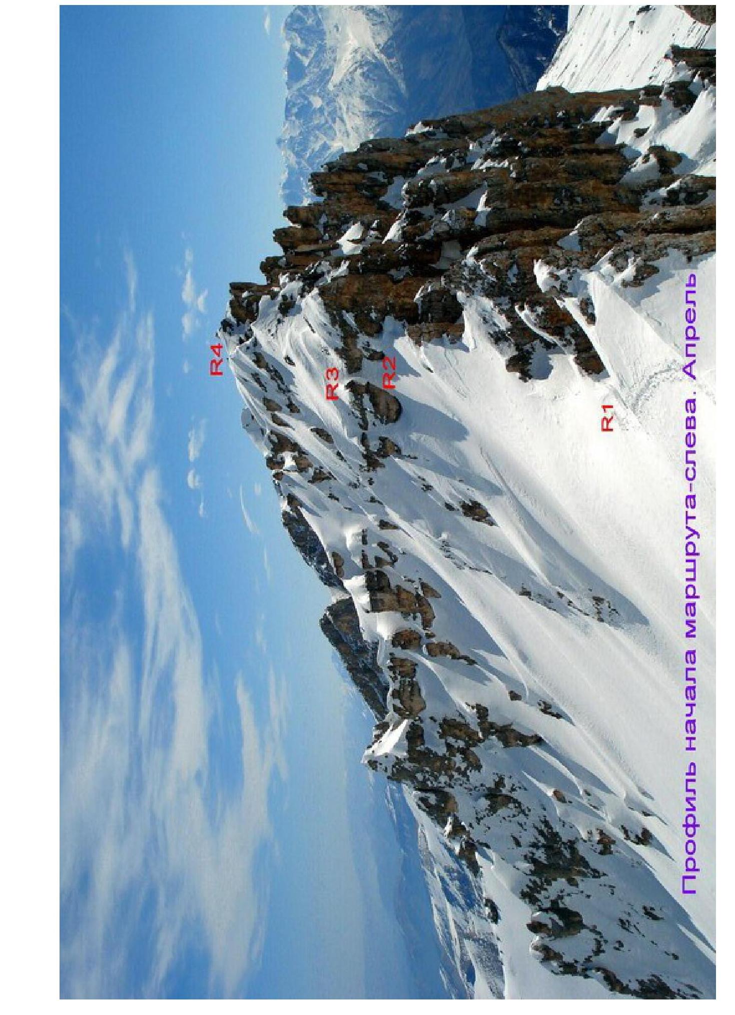
PROFILE OF THE ROUTE START — LEFT. APRIL

Map of Bodeguasim 3 Dinési 10000
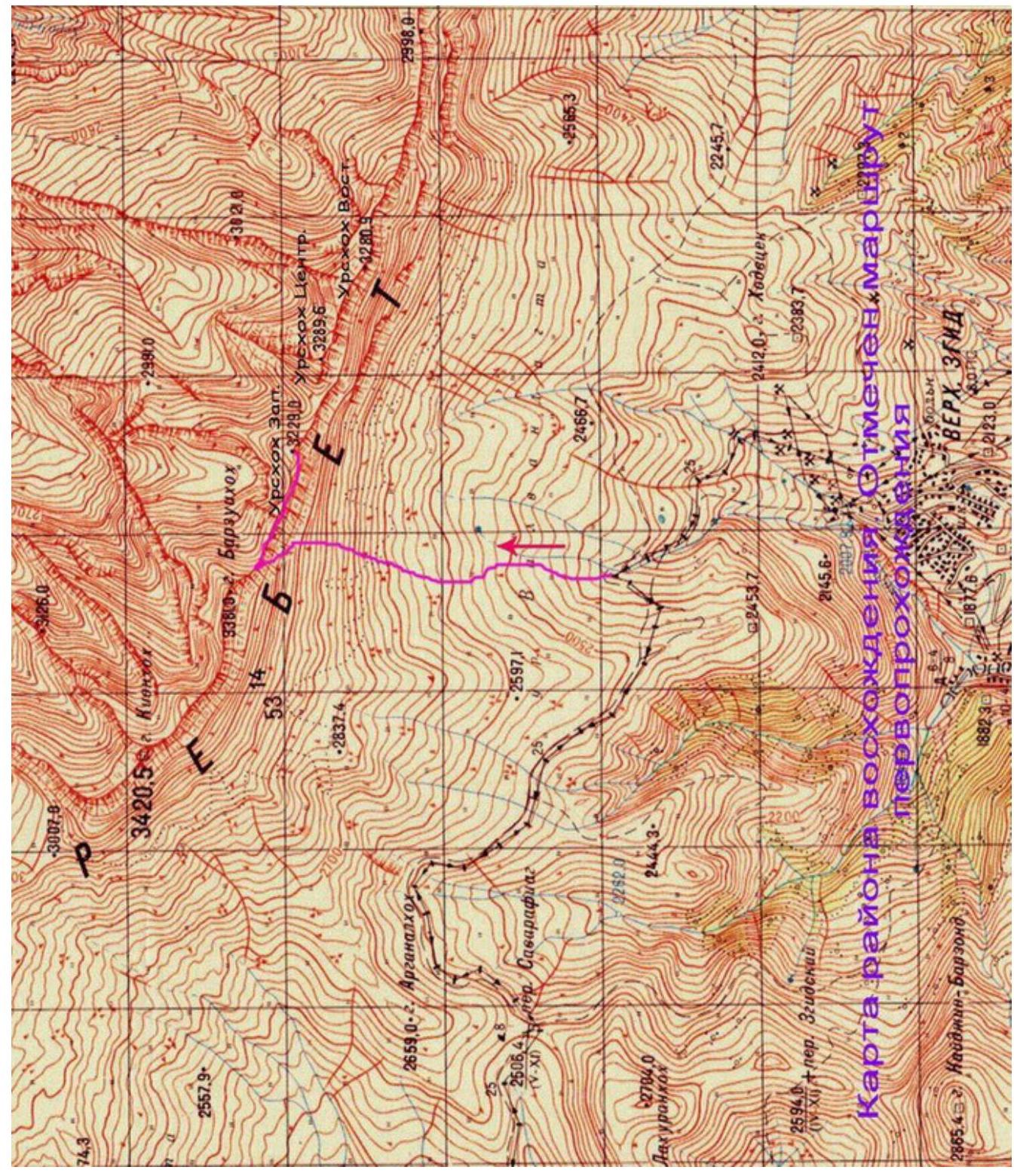
Kionsky massif — brief overview of the area.
Kionsky massif is located in the Republic of North Ossetia-Alania, between the Ardon River to the East and the Urukh (Iraf) River to the West. Kionsky massif is part of the Rocky Ridge, which is well-defined in Kabardino-Balkaria and North Ossetia.
The entire Kionsky massif stretches from Northwest to Southeast for 30 km. Its highest point is the peak Kionkhokh — 3421 m.
Numerous small rivers flow from the Northern slopes of the massif, belonging to the Terek River basin.
The massif is poorly developed from the North; roads are sparse, and approaches from there are difficult and lengthy.
To the South, the Kionsky massif almost along its entire multi-kilometer length ends in steep walls, with a height difference from 100 to 300 m.
Below the walls lie alpine meadows.
The rocks composing the Kionsky massif are sedimentary in origin, including:
- limestones
- dolomites
Marble is found in some places. The rocks are mostly destroyed and heavily weathered. Therefore, the crest of the Rocky Ridge is heavily indented here. In the scree on the slopes, one can often find fossilized mollusk shells.
Due to the strong weathering of the rocks on the slopes of the massif, there is a lot of scree. The highest point of the massif — the peak Kionkhokh — translates from Ossetian (Kайonkhokh) as "slab, scree mountain".
The climate of the Rocky Ridge is specific and unlike the rest of the weather in the North Caucasus mountains. Cyclones coming from the North release most of their precipitation on the Northern slopes of the Rocky Ridge, while cyclones coming from the South mostly unload on the Lateral and Watershed Ridges.
The climate on the Southern slopes is much drier than on the Northern slopes due to the formation of a so-called "rain shadow" zone. Thanks to this and the Southern exposure, snow melts quickly even in winter on the Southern walls.
The most interesting part of the Kionsky massif from a sports perspective is the central part, starting from the peaks Barzond Tsagveri to the peaks Urskhokh above Upper Zgid. This part of the ridge has peak heights of more than 3000 m over a distance of almost 10 km.
Since the mid-1990s, climbers from North Ossetia have been actively developing the central part of the Kionsky massif. Due to the convenience of approaches, all routes have been climbed from the South.
From the city of Vladikavkaz to the village of Upper Zgid, one can travel in 1.5–2 hours. Access:
- A scheduled bus runs once a day after lunch to the village.
- The bus returns early in the morning.
One can drive further above the village, but only in high-clearance vehicles. In this case, it takes about half an hour to walk from the vehicle to the overnight camping site under Urskhokh.
The routes in the area are convenient for climbing in winter and during the off-season:
- close approaches;
- ascents can be made in virtually any weather;
- most routes are ridge routes and, as a rule, not prone to avalanches.
There is "Megafon" cellular coverage on the routes and at the overnight camping sites.
To date, 10 classified routes have been climbed in the central part of the Kionsky massif. Four of them are on Urskhokh East and Central.
- Urskhokh Central from the South — 1B cat. diff.
- Urskhokh Central along the Southern terrace of the Western ridge — 3A cat. diff.
- Urskhokh East along the Western ridge — 2A cat. diff.
- Urskhokh East along the Eastern ridge — 1B cat. diff.
Until July 2013, there were no ascents to Urskhokh West. This report presents a description of the first ascent to Urskhokh West along the Western ridge.
Description of approaches to the route.
From the city of Vladikavkaz to the village of Upper Zgid, take a scheduled bus — about 2–2.5 hours. Passing through the village, head North towards the visible Rocky Ridge. The path goes along a dirt road that leads through the Savaraftsag pass (2506 m) to the neighboring valley of the Aygamugdon River to the villages of Dunta and Kamunta.
Half an hour from the village of Upper Zgid, start ascending North. The road then turns left, West, towards the Savaraftsag pass.
One needs to continue straight up towards the triangular peak of Urskhokh Central. Ascending from the road along the river, one can camp at the end of the stream formed by springs that do not freeze even in winter. It takes about an hour to walk from the road to the camping site.
GPS coordinates of the camping site in WGS-84 format:
| Elevation | N (North latitude) | E (East longitude) |
|---|---|---|
| 2530 m | 42° 53.637′ | 043° 58.185′ |
Characteristics of route sections.
| Section | Length (m) | Steepness, degrees | Terrain characteristics | Cat. diff. | Number of hooks |
|---|---|---|---|---|---|
| R0–R1 | 300 | 20-50 | Rocky-scree slope. | 1-3 | - |
| R1–R2 | 100 | 20-30 | Rocky-scree ridge | 1 | - |
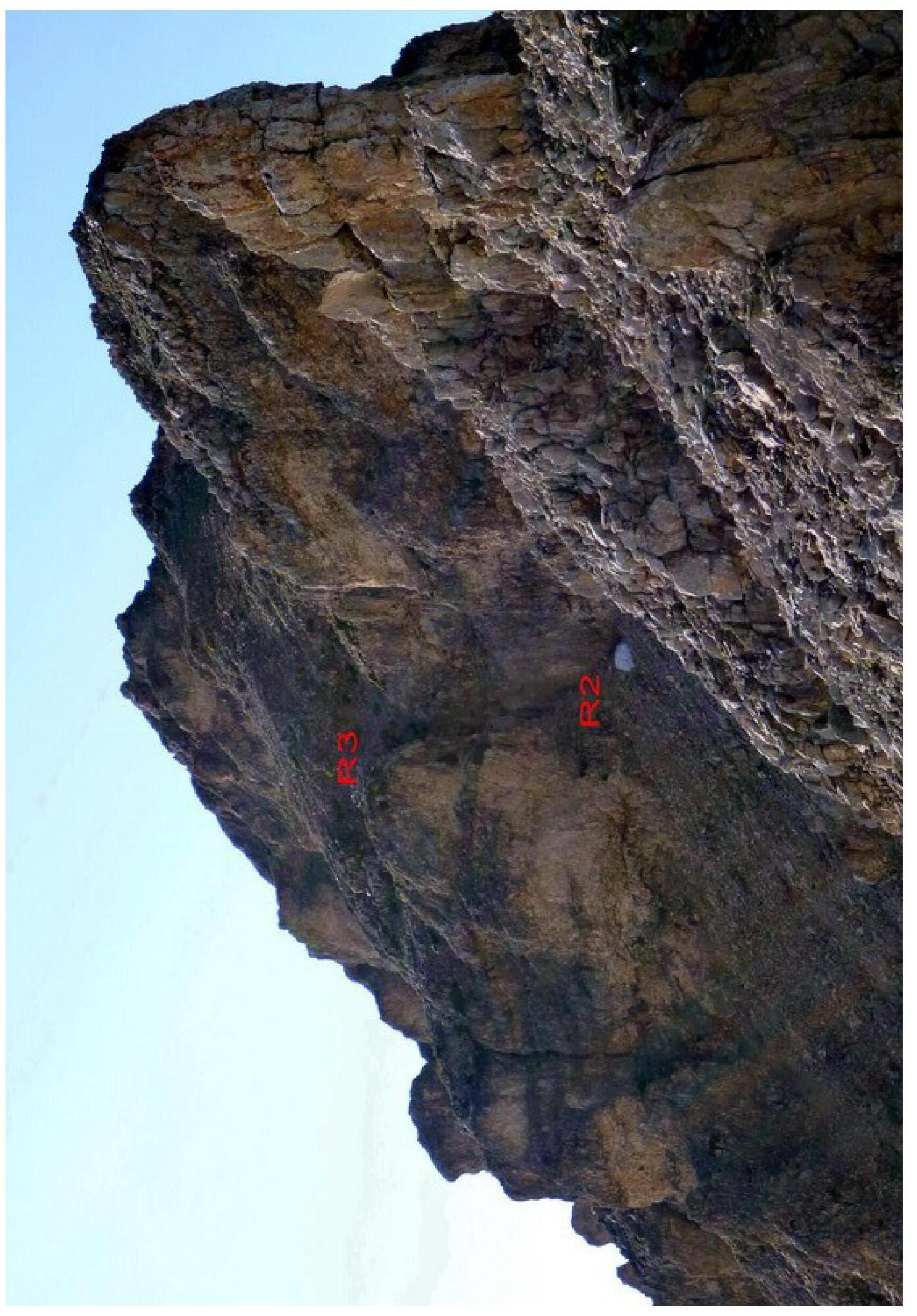
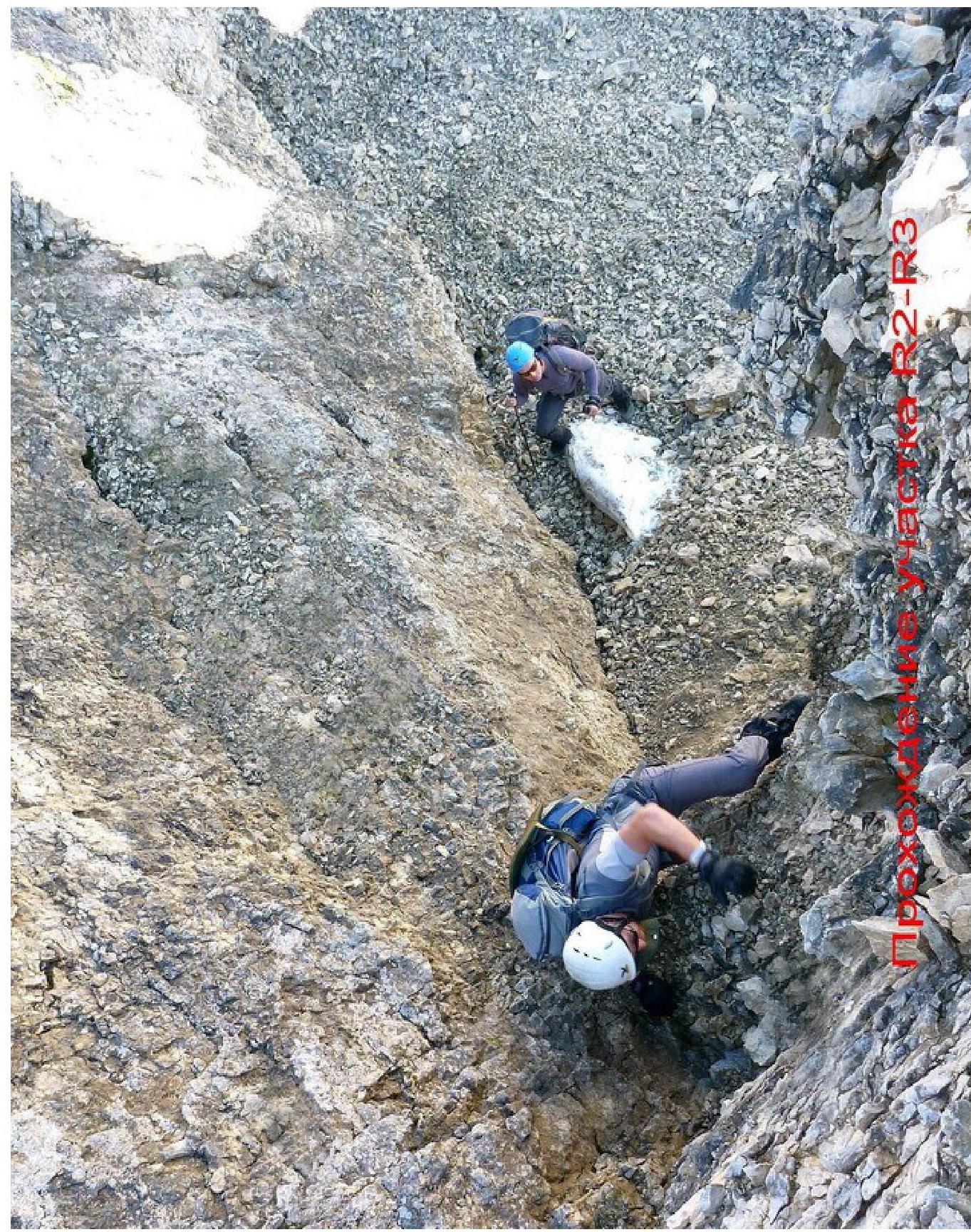
| R2–R3 | 15 | 40-60 | Chimney | 2-4 | 2 |
| R3–R4 | 150 | 20-40 | Rocky-scree slope and ridge | 1-2 | - |
| :-- | :-- | :-- | :-- | :-- | :-- |
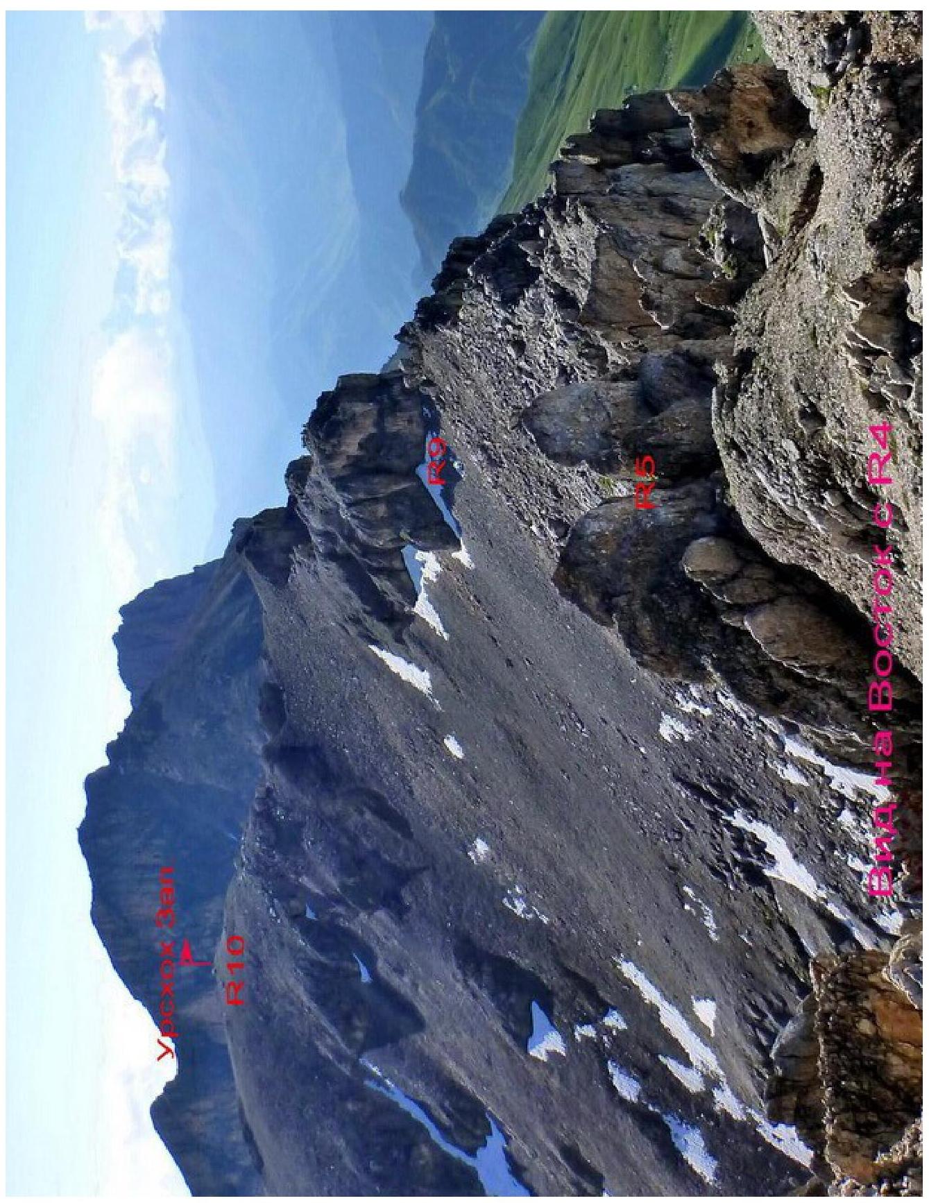
| R4–R5 | 100 | 20-30 | Rocky-scree ridge | 1-2 | - |
| R5–R6 | 25 | 50-70 | Rocky internal angle | 3-4 | 2 |
| R6–R7 | 60 | 20-40 | Rocky-scree slope | 1-2 | - |
| R7–R8 | 50 | ||||
| 20-30 | Rocky-scree slope | 1-3 | 1 | ||
| R8–R9 | 200 | 20-30 | Rocky-scree ridge | 1-2 | - |
| R9–R10 | 200 | 20-30 | Rocky-scree ridge | 1-2 | - |
Description of the route by sections.
From the camping site under Urskhokh Central, one needs to head West towards the col between Barzuikhokh and Urskhokh West.
It's better to walk along the boundary between the alpine meadows and the scree. The starting point of the ascent to the ridge of the Kionsky massif is a point with GPS coordinates:
| Elevation | N (North latitude) | E (East longitude) |
|---|---|---|
| :-- | :--: | :--: |
| 2950 m | 42° 54.335′ | 043° 57.598′ |
A visual landmark for the start of the ascent is the narrowest place in the Southern walls.
R0–R1: Straight up through a narrow rocky belt (10 m, 2–3 cat. diff.), composed of destroyed limestone, to reach the scree slope. Then ascend under the rocks and move left upwards under the walls for about 200 m until reaching the col of the Kionsky massif. The entire section is about 300 m, 1–3 cat. diff., 20–50°.
Stages listed:
- Ascent through a narrow rocky belt (10 m, 2–3 cat. diff.)
- Reaching the scree slope
- Ascent under the rocks and movement left upwards under the walls (~200 m)
- Reaching the col of the Kionsky massif
R1–R2: On the col, turn right and follow the Northern slopes of the Western ridge to reach under the rocky belt with a chimney in the middle. Section length 100 m, 20–30°, 1 cat. diff.
R2–R3: Further up through the left part of the chimney, 2–4 cat. diff., 15 m, 40–60°
R3–R4: After the chimney, move right upwards onto the Western ridge. Then straight along the ridge, bypassing complex sections on the left, through a series of small destroyed gendarmes, to reach the upper part of the ascent of the Western ridge. Here is a control point. Further, the ridge descends slightly.
- Total length of the section about 150 m
- 20–30°
- 1–2 cat. diff.
R4–R5: Descend along the ridge line towards the double gendarme. Reach a narrow saddle between the gendarmes.
Section:
- Length: 100 m
- Angle: 20–30°
- Cat. diff.: 1–2
R5–R6: On the saddle, there is a rocky "finger". From it, rappel straight down along a vaguely expressed internal angle. Down the rocks, 3–4 cat. diff., 50–70°, 25 m — descend to a narrow ledge.
R6–R7: Along the ledge, head right, under the rusty walls, to reach the ridge behind the triangular gendarme (40 m). Then descend slightly, 20 m left downwards, left of the ridge line, towards a sharp bend in the slope to the East.
- Entire section 20–40°, 1–2 cat. diff.
- Rocks are destroyed — movement is intermittent.
R7–R8: Further movement right downwards — descent into a rocky hollow. Insurance is complicated — one can use the bend in the slope and insure from the ridge. Descent goes along destroyed rocks, 2–3 cat. diff., 40–50°, about 10 m. After descending, cross the hollow and ascend onto the Northern slope of the Western ridge. Total section length — 50 m.
Sections R5–R8 are the key sections of the route to the peak Urskhokh West along the Western ridge.
R8–R9: Along the Northern slopes of the Western ridge, sometimes reaching the ridge line, move 200 m East towards the pre-summit ascent. Section 1–2 cat. diff., 20–30°.
R9–R10: Rocky outcrops of the pre-summit ascent are bypassed on the left, along the Northern slopes. With a large amount of snow, there is an avalanche risk! Behind the rocky outcrop, reach the Western ridge and, 200 m from the start of the section, ascend to the peak Urskhokh West.
The entire section:
- 1–2 cat. diff.
- 20–30°.
The peak is a wide scree dome. No signs of human presence were found.
Descent is along the ascent route or further East towards Urskhokh Central (route — traverse Urskhokh West — Urskhokh Central).
Conclusions and recommendations for the route.
The route is recommended for:
- training ascents for sports groups,
- educational ascents.
Based on the route length, characteristics of key sections, and comparing it with nearby routes of 2A cat. diff., it can be argued that the first ascent route corresponds to a route of 2B cat. diff.
When passing the route, one must follow the description exactly to avoid complex sections. Recommendations for equipment:
- chocks
- 50 m ropes
- slings for organizing rappel
Digitized using Google
Ljudfer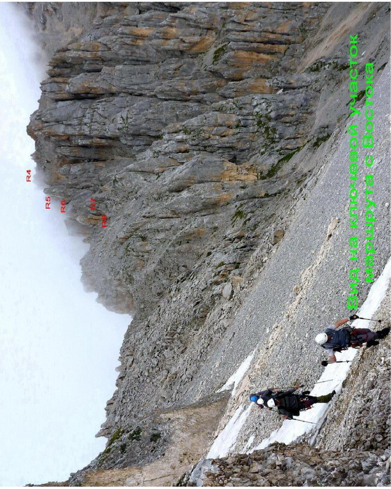
Digitized using Google.