Ascent Certificate
- Ascent category — rock climbing.
- Ascent area: Caucasus, Rocky Ridge.
- Peak 3280 m (Kionsky massif), via the Western ridge.
- Estimated category of complexity 2A — first ascent.
- Height difference: 600 m. Total route length — 1200 m. Average steepness of the route 30°.
- Pitons left on the route — none. Use of previously driven pitons — none.
- Number of travel hours/days: 6 h/1.
- Overnight stays: none.
- Leader: Egorin Sergey Vladimirovich, Candidate Master of Sports.
Team members:
- Bondarenko Alexander Olegovich, 3rd sports category
- Bychkov Boris Nikolaevich, 3rd sports category
- Ivanov Vitaly Valentinovich, Candidate Master of Sports
- Sushko Alexander Pavlovich, Master of Sports
- Coach: Korablin Boris Nikolaevich, Master of Sports, Honored Coach of the RSFSR.
- Entry to the route: February 4, 1995. Summit — February 4, 1995. Return — February 4, 1995.
- Organization: North Ossetian Republican Search and Rescue Service of the Ministry of Emergency Situations of Russia.
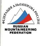
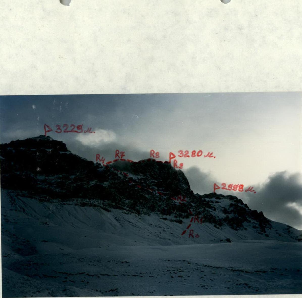
P3229 m. R4, R7, R8, P3280 m, R9, R2–R1, R0. Peak 3280 meters from the south. The first ascent route is marked. February.
Photopanorama of the ascent area. View from the southeast from Verkhny Zgid village. April. The first ascent route is marked. April.

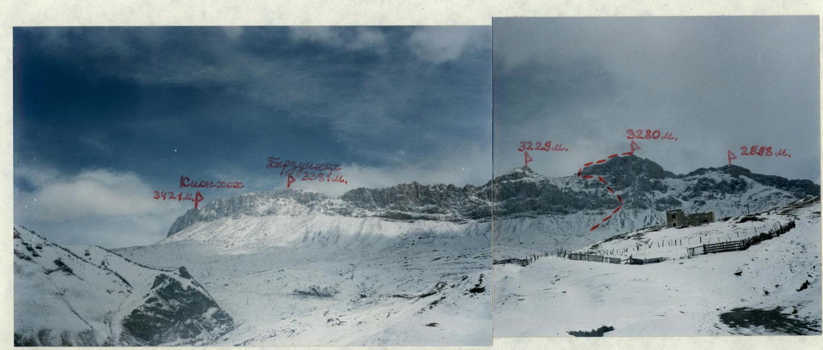
Photopanorama of the ascent area. View from the southwest from the left bank of the Songutidon river gorge. September. The first ascent route is marked.
Photopanorama of the ascent area. View from the south and from Vizbora peak. July. The first ascent route is marked.
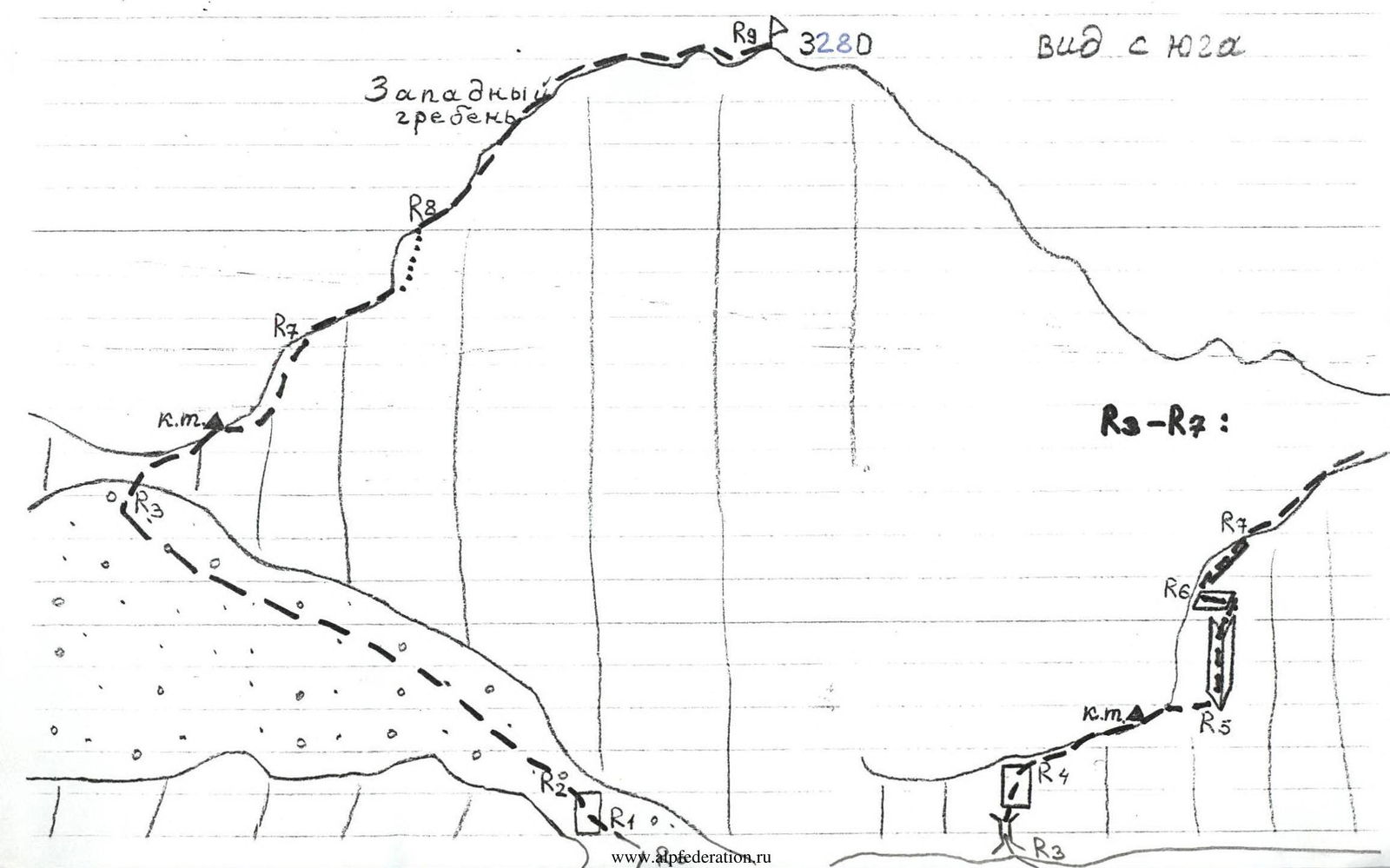
Route profile on the left. April.
Route Description
Section R0–R1:
- Approach the southern walls of peak 3280 m, move along the scree under the walls, lying below the saddle, which is located to the left (west) of the peak 3280.
- Then approach the narrow scree passage through the lower rock belt.
- Move up the scree (1) under the wall.
Section R1–R2: Climb up the right part of the wall to the scree above — “live” stones! The wall is category 3–3+ complexity, 15 m.
Section R2–R3: Move up to the left, under the walls on the right, to the saddle between peaks 3280 m on the right and 3229 m on the left (1).
Section R3–R4: Approach the southern walls of the saddle and climb up the chimney (3, 6 m) to the ridge (wall 3, 5 m).
Section R4–R5: Move along the southern side of the ridge, traverse right along a smooth plate (3+, 4, 5 m). Then reach the ridge and move along the wide ridge, scree, to the gendarme (ridge 1–2).
Time from the start of the ascent to the saddle: 1 h 00 min.
Time from the start of the route: 3–3.5 h.
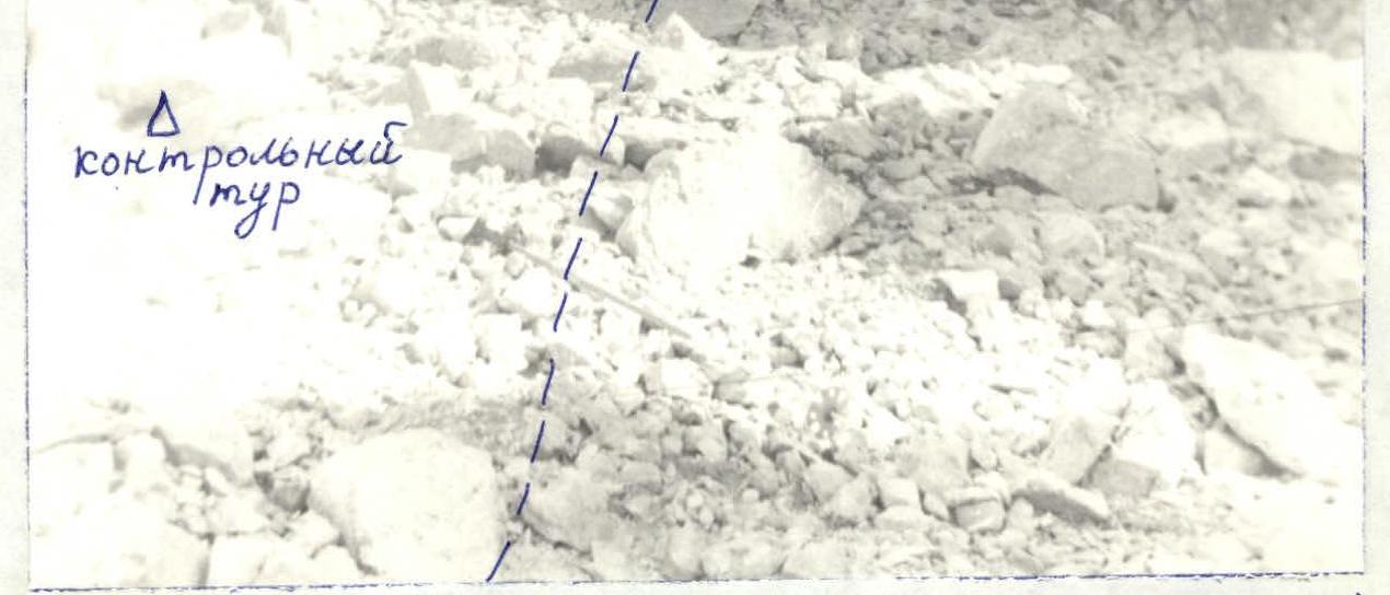
Here, under the gendarme, on a ledge — a control cairn.
Section R5–R6: Climb up the center of the gendarme via the left part of the inner corner (3+, 4, 10 m). Then move left, traverse along a ledge (3, 5 m).
Section R6–R7: After passing the ledge, climb up the edge to the ridge (2, 15 m).
Section R7–R8: Move along the ridge (2–3), sometimes bypassing difficult sections on the left along the northern slopes (plates 3).
Section R8–R9: Climb up the Western ridge (2–3) to the summit of peak 3280 m. 2.5–3 h from the control cairn.
Descent via the Eastern ridge (about 1B) takes 3–3.5 h to the road.
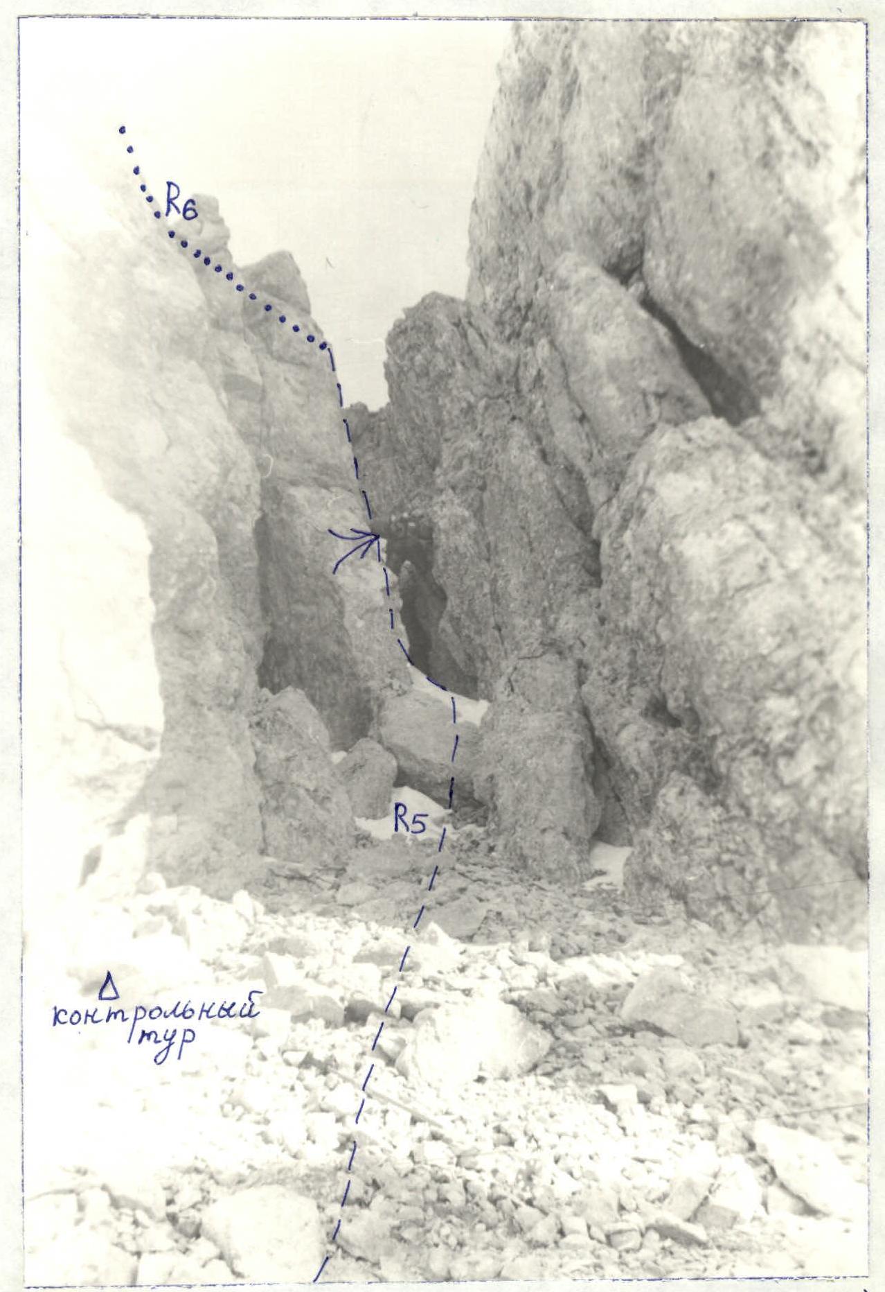
Passing the inner corner (section R5–R6).