II. ASCENT PASS
- ASCENT CLASS — TECHNICAL
- ASCENT REGION — 2.7
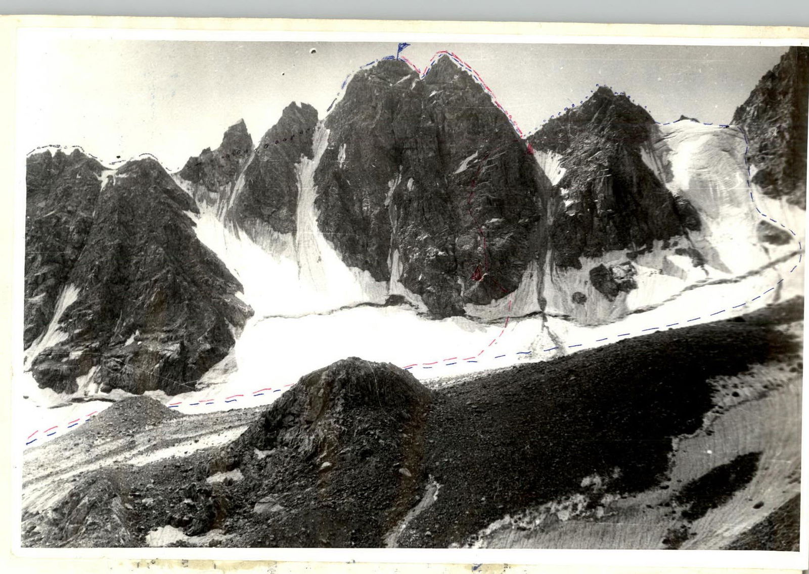
- PEAK — MALAYA SONGUTI, 3800 m, VIA NORTH-WEST COUNTERFORT OF NORTH WALL
- PROPOSED DIFFICULTY CATEGORY — 4A
- ROUTE CHARACTERISTICS: ELEVATION GAIN 500 m, AVERAGE STEEPNESS 70°, LENGTH OF SECTION II — 40 m, III — 490 m, IV — 155 m, V — 45 m
- PITS DRIVEN: ROCK — 16, BOLTS — 0, ICE — 1
- TOTAL CLIMBING TIME — 8 hours
- NIGHTS SPENT ON ROUTE — NONE
- NAME AND SPORTS QUALIFICATION OF TEAM LEADER AND PARTICIPANTS TEAM LEADER — SHILO OLEG LEONIDOVICH — Candidate for Master of Sports ZHIVLENEV VLADIMIR NIKOLAEVICH — 1st sports category GOKINAEV ALEXANDR NIKOLAEVICH — 2nd sports category LITSKKEVICH VLADIMIR IOSIFOVICH — 1st sports category
- TEAM COACH — AKRYTOV IVAN PANAYOTOVICH
- DATE OF DEPARTURE AND RETURN DEPARTURE FROM CAMP — August 1, 1979 SUMMIT ASCENT — August 2, 1979 RETURN TO CAMP — August 5, 1979
Route 3A (2.7.106)
Route 3B
Route 4A (2.7.107)
First ascent route.
Approach Description
The approach to the peak is described in A.F. Naumov's book "Karaugom, Digoriya, Tsey", but an alternative path can be proposed.
From the "Torpedo" recreation center, take the highway down. From the Tsey village, go up along the trails leading to the upper hayfields in the direction of the fork in the road between the abandoned mine and the TV repeater. (It's possible to drive to this fork by car.)
From the fork:
– head towards the mine along the road (in some cases, it's possible to cut the switchbacks); – from the mine, go right — up along a good trail to the ridge; – up the ridge for 200–250 m, then down the trail into the valley between the peaks Sadon and Sau-khok (in A.F. Naumov's book, this peak is referred to as Unnamed); – in the valley, there's a plateau — an abandoned geologists' campsite.
From the plateau:
– go up the scree slopes ("rusty") to the saddle between Mt. Sadon and Mt. Sau-khok; – from the saddle, go down (along the stream) and descend along the scree to a small cirque glacier; – along the glacier (completely covered with large scree), go left and down, bypassing the Western ridge of Peak Burevestnik-Tseyskiy; – after bypassing the ridge, go sharply up the scree slopes to the platforms near Turye Lake.
The journey from the fork to the campsite takes 4.5–5 hours.
Description of the ascent route to Mt. M. Songuti via the North-West counterfort (through the Western tower) — approximately 4A category of difficulty.
From the initial bivouac (Turye Lake), head to the bergschrund. From the bergschrund, go right, leaving the lower end of the counterfort to the left, and circumvent it. At a height of 40 m from the bergschrund, there's an exit to a small shoulder at the beginning of the counterfort. From a distance, the start of the counterfort appears as a rhombus. On the vertex of the rhombus, on the shoulder, there's the 1st control cairn.
To the shoulder — easy rocks (30–40 m). From the cairn, go straight up along a clearly defined ridge (40 m) — with piton belay. Within these 40 m, there's a rock wall (4–5 m) — the first key section.
After the wall:
– go left and up along the scree shelves to an inclined platform (50 m); – from the platform, go left and up along the ridge, then along easy rocks to a crevice (35 m); – through the crevice (35 m) — to platforms in the form of terraces.
At the base of the Western tower, there's always a large snow-ice patch. The rocks below the patch are covered with ice. Before reaching the patch, make a sharp traverse to the right along one of the terraces. The terraces are long, inclined wide shelves-slabs.
Further movement:
– right and up towards the shoulder of the Western tower (150–160 m); – along the way to the shoulder, when transitioning from one terrace to another, there's the second key section — an internal corner (8–10 m); – on the shoulder — the second control cairn.
From the cairn, easy rocks (40 m) lead to a chimney at the base of the Western tower, to the right of the ascent route. The chimney is the third key section of the route and is more challenging than the first two. The chimney is 10–12 m long, and the approach to it from the shoulder (5–6 m) requires careful piton belay. In the middle of the chimney, there's a plug made of two stones.
After the chimney:
– go left and up along a vaguely defined angle — moderate climbing (10–15 m); – then sharply left (3–4 m); – and along rocks of moderate difficulty, right and up to the summit of the Western tower.
Further, the route merges with the classified route to the summit of M. Songuti along the Western ridge — 3B category of difficulty. The descent from the summit is done via the 3A category route along the Eastern ridge.
The journey from the campsite to the summit takes 10–12 hours. There are places on the route suitable for overnight stays.
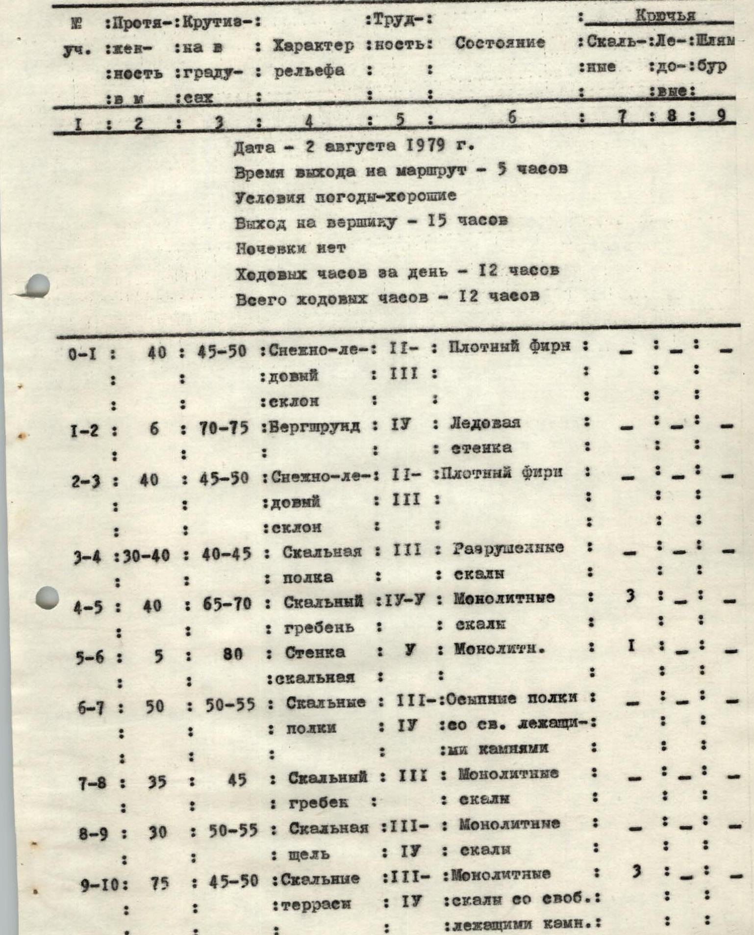
Section table.
Date — August 2, 1979 Time of departure on the route — 5 hours Weather conditions — good Summit ascent — 15 hours No overnight stays Climbing time for the day — 12 hours Total climbing time — 12 hours
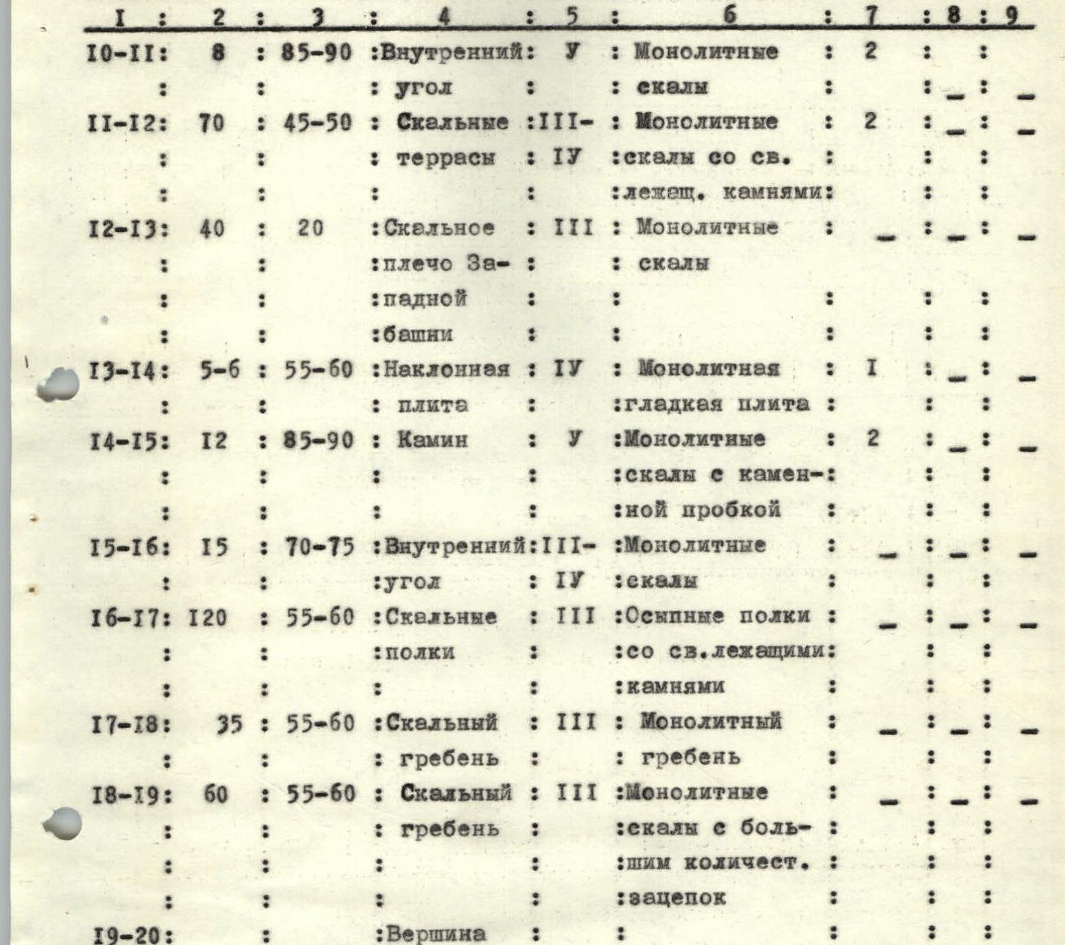
| Section | Length, m | Steepness, ° | Terrain characteristics | Difficulty | Condition | Pitons (rock) | Pitons (ice) | Pitons (bolts) |
|---|---|---|---|---|---|---|---|---|
| R0–R1 | 40 | 45–50 | Snow-ice slope | 2–3 | Dense firn | |||
| R1–R2 | 6 | 70–75 | Bergschrund | 4 | Ice wall | |||
| R2–R3 | 40 | 45–50 | Snow-ice slope | 2–3 | Dense firn | |||
| R3–R4 | 30–40 | 40–45 | Rock shelf | 3 | Broken rocks | |||
| R4–R5 | 40 | 65–70 | Rock ridge | 4–5 | Monolithic rocks | 3 | ||
| R5–R6 | 5 | 80 | Rock wall | 5 | Monolithic rocks | 1 | ||
| R6–R7 | 50 | 50–55 | Rock scree shelves | 3–4 | With loose rocks | |||
| R7–R8 | 35 | 45 | Rock ridge | 3 | Monolithic rocks | |||
| R8–R9 | 30 | 50–55 | Rock crevice | 3–4 | Monolithic rocks | |||
| R9–R10 | 75 | 45–50 | Rock terraces | 3–4 | Monolithic rocks with loose rocks | 3 | ||
| R10–R11 | 8 | 85–90 | Internal corner | 5 | Monolithic rocks | 2 | ||
| R11–R12 | 70 | 45–50 | Rock terraces | 3–4 | Monolithic rocks with loose rocks | 2 | ||
| R12–R13 | 40 | 20 | Rock shoulder of Western tower | 3 | Monolithic rocks | |||
| R13–R14 | 5–6 | 55–60 | Inclined slab | 4 | Monolithic smooth slab | 1 | ||
| R14–R15 | 12 | 85–90 | Chimney | 5 | Monolithic rocks with a stone plug | 2 | ||
| R15–R16 | 15 | 70–75 | Internal corner | 3–4 | Monolithic rocks | |||
| R16–R17 | 120 | 55–60 | Rock scree shelves | 3 | With loose rocks | |||
| R17–R18 | 35 | 55–60 | Rock ridge | 3 | Monolithic ridge | |||
| R18–R19 | 60 | 55–60 | Rock ridge | 3 | Monolithic rocks with many holds | |||
| R19–R20 | Summit |