Ascent Passport
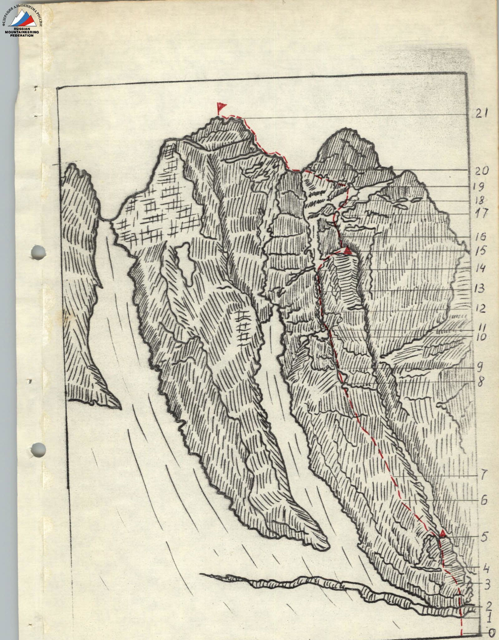
I. Ascent Class: Technical 2. Ascent Area: 2.7 3. Summit: Malaya Songuti 3800 m via Central Counterfort of the North Face 4. Proposed Difficulty Category: 4A 5. Route Nature: Height difference 500 m, average steepness 70–75°. Section length: II – 60 m, III – 260 m, IV – 290 m, V – 25 m 6. Pitons driven: For belay: Rock — 16 Boulder — 0 Ice — 1 For creating ITO: Rock — 2 Boulder — 0 Ice — 0 7. Number of climbing hours: 8 h 8. Overnight stays: None 9. Full name of the leader and participants and their sports qualification: Leader — Shilo Oleg Leonidovich, Candidate for Master of Sports Bondarenko Nikolai Grigorievich — 1st sports category Smirnov Vyacheslav Alexandrovich — 1st sports category 10. Team Coach: Akryitov Ivan Panayotovich II. Date of departure on the route and return: Departure from camp — August 23, 1979 Summit ascent — August 24, 1979 Return to camp — August 27, 1979
Route 3A (2.7.106)
 Route 4B (2.7.107)
First ascent route
Route 4B (2.7.107)
First ascent route
Route Description to the summit of M. Songuti via the Central Counterfort of the North Face
Approximately 4A category of difficulty
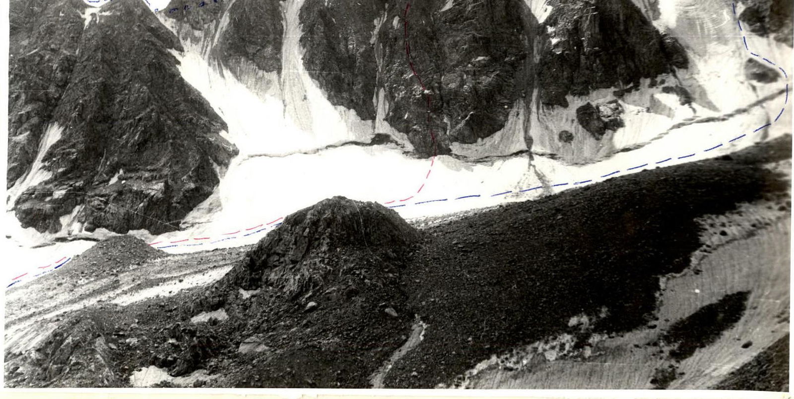
From the bivouac at Turye Lake under the Malaya Songuti glacier, ascend along the left-bank moraine (in the direction of travel) to the glacier tongue. Crossing the glacier from left to right, approach the base of the Central Counterfort. Along the ice-snow slope (R0–R1), approach the bergschrund. Overcome the bergschrund in the lowest part of the counterfort rocks (R1–R2). The bergschrund is overcome by descending downwards approximately 3 m, traversing left – 3–4 m, and using an ice wall to exit onto the rocks. Belay via ice screws.
Along the destroyed rocks of medium difficulty, transitioning into monolithic smoothed slabs in the upper part (R2–R3), move towards the first small bastion — the "fork". Loose rocks, piton belay. Through the internal angle with monolithic slabs and numerous holds, pass between the "humps" of the fork and exit onto the right shoulder of the bastion-fork. On the shoulder is a control cairn (R4–R5).
Then, along the rocky debris shelves (R5–R6) on the right side of the counterfort ridge, exit onto the ridge (R6–R7). Along the rocks of medium difficulty on the ridge, approach the internal angle (R7–R8). Through the internal angle with monolithic walls (rocks above medium difficulty, piton belay), approach the base of the bastion. The base of the bastion is passed through a vertical narrow crack with an overhang in the lower part (R8–R9, R9–R10).
Further along the crack (R10–R11) and monolithic rock shelves (R11–R12) (loose rocks), approach under the spall. The monolithic smooth slab with a crack (R12–R13) is bypassed on the left along a smooth inclined slab with a crack (piton belay), exiting onto a shelf under the "black internal angle" (R13–R14) — the key point of the route. The "black internal angle" is overcome directly head-on along the overhanging lower section using artificial holds (piton belay).
Further along the chimney (R14–R15) with monolithic smoothed rocks — exit onto the bastion. On the bastion is the second control point. Along the rocky shelves (R15–R16) and a smooth inclined slab (R16–R17), approach under the wall to the left of the chimney with black walls. The wall (R17–R18) is overcome head-on along rocks above medium difficulty (piton belay).
Then, along monolithic inclined slabs (R18–R19), approach under the base of the Western Tower (many loose rocks on the slabs). Along a vaguely defined rock shelf (strongly destroyed rocks, R19–R20) — a difficult traverse left — exit onto the saddle between the summit of M. Songuti and the Western Tower.
Along the sharp rocky ridge (R20–R21) with numerous holds — exit onto the summit.
Descent along the Eastern Ridge via route 3A category of difficulty. Route duration from the bivouac on Turye Lake – 10–12 h.